Vigía del Fuerte
| Vigía del Fuerte | ||
|---|---|---|
| Municipality and town | ||
| ||
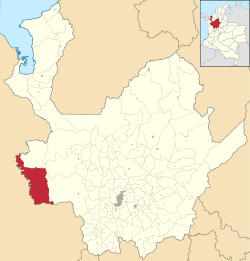 Location of the municipality and town in the Antioquia Department of Colombia | ||
 Vigía del Fuerte Location in Colombia | ||
| Coordinates: 6°35′20″N 76°53′45″W / 6.58889°N 76.89583°W | ||
| Country |
| |
| Department |
| |
| Subregion | Urabá | |
| Elevation | 12 m (39 ft) | |
| Time zone | UTC-5 (Colombia Standard Time) | |
.svg.png)
Vigía del Fuerte is a town and municipality in the Colombian department of Antioquia. The town is on the eastern bank of the Atrato River, which is locally the boundary between the Antioquia and Chocó Departments of Colombia.[1]
The town is served by Vigía del Fuerte Airport.
Armed conflict
As of 2013, FARC rebels of the 57th and 34th fronts Northwestern Bloc of the FARC-EP are present in the municipality. On October 11th 2013, presumed FARC rebels attacked the municipality's airport, destroying an aircraft in the process.[2]
See also
![]()
References
Capital: Medellín | |||||||||||||||||||
| Regions and municipalities |
| ||||||||||||||||||
| Related topics | |||||||||||||||||||
This article is issued from
Wikipedia.
The text is licensed under Creative Commons - Attribution - Sharealike.
Additional terms may apply for the media files.