Armenia, Antioquia
| Armenia, Antioquia | ||
|---|---|---|
 | ||
| ||
| Nickname(s): Armenia Mantequilla | ||
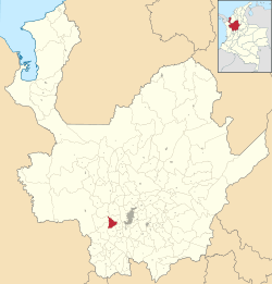 Location of Armenia within Antioquia Department | ||
 Armenia, Antioquia Location in Colombia | ||
| Coordinates: 6°9′23″N 75°47′14″W / 6.15639°N 75.78722°WCoordinates: 6°9′23″N 75°47′14″W / 6.15639°N 75.78722°W | ||
| Country |
| |
| Departamento |
| |
| Subregion | Western | |
| Founded | 1864 | |
| Government | ||
| • Mayor | José Ignacio Cuartas Quiroz | |
| Area | ||
| • Total | 110 km2 (40 sq mi) | |
| Elevation | 1,800 m (5,900 ft) | |
| Population (2002) | ||
| • Total | 7,006 | |
| • Density | 63.7/km2 (165/sq mi) | |
| Time zone | UTC-5 (Colombia Standard Time) | |
.svg.png)
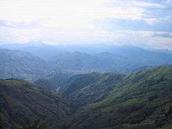
Armenia, also known as Armenia Mantequilla (Spanish for Butter Armenia) to avoid confusion with other Armenias, is a municipality in the western region of the Antioquia Department, Colombia.
References
Capital: Medellín | |||||||||||||||||||
| Regions and municipalities |
| ||||||||||||||||||
| Related topics | |||||||||||||||||||
This article is issued from
Wikipedia.
The text is licensed under Creative Commons - Attribution - Sharealike.
Additional terms may apply for the media files.