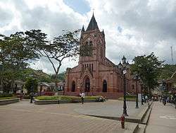
San Roque, Antioquia
| San Roque, Antioquia | |||
|---|---|---|---|
| Municipality and town | |||
 | |||
| |||
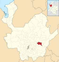 Location of the municipality and town of San Roque in the Antioquia Department of Colombia | |||
 San Roque, Antioquia Location in Colombia | |||
| Coordinates: 6°29′7″N 75°1′11″W / 6.48528°N 75.01972°WCoordinates: 6°29′7″N 75°1′11″W / 6.48528°N 75.01972°W | |||
| Country | Colombia | ||
| Department | Antioquia Department | ||
| Subregion | Northeastern | ||
| Founded | 8 February 1880 | ||
| Area | |||
| • Municipality and town | 441 km2 (170 sq mi) | ||
| Elevation | 1,475 m (4,839 ft) | ||
| Population (2015) | |||
| • Municipality and town | 16,789 | ||
| • Density | 38/km2 (99/sq mi) | ||
| • Urban | 6,298 | ||
| • Metro | 10,493 | ||
| Time zone | UTC-5 (Colombia Standard Time) | ||
.svg.png)
.svg.png)
San Roque is a town and municipality in the Colombian department of Antioquia. It is part of the subregion of Northeastern Antioquia. The municipality was founded by Francisco Martinez de Ospina on the 8 February 1880. The town is located between the Nare River and the Nus River. The town was created due to the presence of gold in the areas around the town. The town is located 121km north of Medellín. The people of this town celebrate most of the traditional festivals that are celebrated in Colombia.
History
San Roque became a municipality in the year 1884. In 1911 the Antioquia Railway is built, traveling near the town and bringing some economy to the area. San Roque was known as a mining center at this time. The past history is what attracts the modern day tourists, and San Roque is often called "The Land of Cordiality" because the natives are so friendly. The name "San Roque" comes from the invocation to the patron of the plagues, as the town's climate is very unhealthy.[1]
References
- ↑ http://www.iprc.org.co, Equipo de Internet para la Rendición de Cuentas -. "Sitio web del municipio San Roque en Antioquia". sanroque-antioquia.gov.co (in Spanish). Retrieved 2017-04-22.
Capital: Medellín | |||||||||||||||||||
| Regions and municipalities |
| ||||||||||||||||||
| Related topics | |||||||||||||||||||