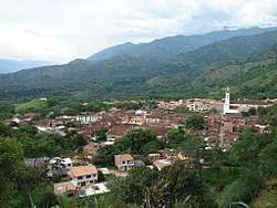
Sopetrán
| Sopetrán | |||
|---|---|---|---|
| Municipality and town | |||
 | |||
| |||
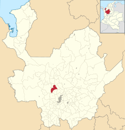 Location of the municipality and town of Sopetrán in the Antioquia Department of Colombia | |||
 Sopetrán Location in Colombia | |||
| Coordinates: 6°26′30″N 75°43′40″W / 6.44167°N 75.72778°W | |||
| Country |
| ||
| Department |
| ||
| Subregion | Western | ||
| Time zone | UTC-5 (Colombia Standard Time) | ||


Sopetrán Is a municipality of Colombia, located in the subregion West of the department of Antioquia. It bounded on the north by the municipality of Olaya, the east with the municipality of Belmira, to the south with the municipalities of San Jerónimo and Ebéjico and west with the municipality of Santa Fe de Antioquia. It is 59 kilometers from the city of Medellin, capital of the department of Antioquia. The municipality has an extension of 223 square kilometers.
Sopetran currently form (2007), part of the trilogy of the Sun Route in western Antioquia. It composed besides itself, in the municipalities of San Jerónimo and Santa Fe de Antioquia, with which it shares much of its history. After the inauguration of Tunnel of the West Fernando Gomez Martinez, their tourist possibilities have tripled from the year 2006. It is a land suitable for ecotourism.
The present municipality of Sopetran was inhabited before the arrival of the Spaniards by Aboriginal communities Nutabes and Tahamíes. It was called when the Iberian arrived, Los Guamas. The official date of its foundation has been established in February 22 of 1616, by Francisco Herrera and Campuzano, a native of Alcala de Henares (Spain). Herrera venerated with great devotion the image of Our Lady of Sopetran, whose nickname the founder moved to this town. 3
Formerly the town was also known by the names of: The Guamas, Vice Parish of Our Lady of Saladito of Cordoba, Parish of Our Lady of the Assumption and Sopetrán.
Its origin was because their lands had settled many centuries ago indigenous guamas or guacas, who were engaged in agriculture, hunting, fishing and the exploitation of salt mines. Circumstance that caught the attention of the Spaniards who had to bring salt of the sea for domestic use and to feed the cattle that had just imported.
In the year of 1814 Sopetrán reached the category of municipality.
References