Chigorodó
| Chigorodó | |||
|---|---|---|---|
| Municipality and town | |||
| |||
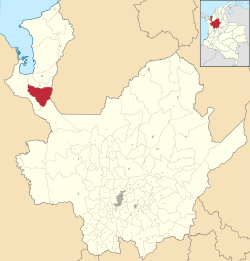 Location of the municipality and town of Chigorodó in the Antioquia Department of Colombia | |||
 Chigorodó Location in Colombia | |||
| Coordinates: 7°40′N 76°41′W / 7.667°N 76.683°W | |||
| Country |
| ||
| Department |
| ||
| Subregion | Urabá | ||
| Founded | 1878 | ||
| Government | |||
| • Mayor | Daniel Alvarez Sosa | ||
| Area | |||
| • Total | 608 km2 (235 sq mi) | ||
| Elevation | 34 m (112 ft) | ||
| Population (2012) | |||
| • Total | 60,667 | ||
| • Density | 100/km2 (260/sq mi) | ||
| Demonym(s) | Chigorodoseños | ||
| Time zone | UTC-5 (Colombia Standard Time) | ||
| Area code(s) | 57 + 4 | ||
| Website | Official website (in Spanish) | ||
.svg.png)
Chigorodó (Spanish pronunciation: [tʃiɣoɾoˈðo]) is a municipality in Antioquia Department, Colombia.
Residents
- Jaime Castañeda, cyclist
This article is issued from
Wikipedia.
The text is licensed under Creative Commons - Attribution - Sharealike.
Additional terms may apply for the media files.