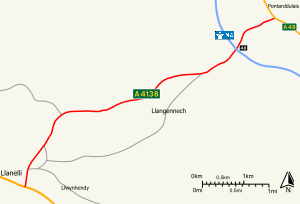
A4138 road
| |
|---|---|
 | |
| Route information | |
| Length | 4.97 mi (8.00 km) |
| Major junctions | |
| East end | Pontarddulais |
|
[[Image:Motorway Left.svg|[ |x22px|link=]] | |
| West end | Parc Trostre |
| Location | |
| Primary destinations | Llanelli |
| Road network | |

The A4138 is a main road in Carmarthenshire, Wales, connecting Pontarddulais with Llanelli. Running in a northeast to southwest direction, the road connects with ![]()
![]()
![]()
![]()
![]()
![]()
![]()
Proposals
- There have been proposals to make the southwestern section from the M4 to Llanelli a trunk road, which would be operated by the Welsh Assembly Government, but these have been rejected. [2]
- The local council has a policy to reject any planning application that would prevent or adversely affect the implementation of a dual carriageway between the M4 and Trostre. [3]
Places served
Settlements served by the road include:
References
Route map:
- ↑ Ordnance Survey. "1:50,000 Landranger Map". Retrieved 13 April 2012.
- ↑ Carmarthenshire County Council (12 December 2002). "REVIEW OF TRUNK ROADS IN WALES 2002". Retrieved 13 April 2002.
- ↑ "Carmarthenshire Council - Unitary Development Plan: Transportation". Carmarthenshire County Council. Archived from the original on 28 December 2013.
Transport in Carmarthenshire | |||||||
|---|---|---|---|---|---|---|---|
| Roads |  | ||||||
| Bus | |||||||
| Cycling | |||||||
| Railway lines | |||||||
| Railway stations |
| ||||||
| Air | |||||||
This article is issued from
Wikipedia.
The text is licensed under Creative Commons - Attribution - Sharealike.
Additional terms may apply for the media files.