River Severn
The River Severn (Welsh: Afon Hafren) is the longest river in Great Britain at a length of 220 miles (354 km).[4][5] With an average discharge of 107 m3/s (3,800 cu ft/s) at Apperley, Gloucestershire, it has by far the greatest water flow in England and Wales.
| River Severn Welsh: Afon Hafren | |
|---|---|
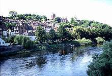
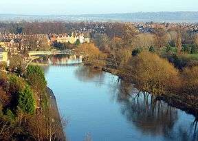 The river seen from Shrewsbury Castle | |
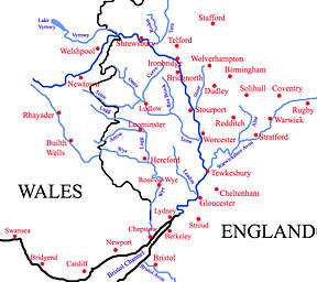 Tributaries (light blue) and major settlements on and near the Severn (bold blue) | |
| Location | |
| Country | England and Wales |
| Region | Mid Wales, West Midlands, South West |
| Counties | Powys, Shropshire, Worcestershire, Gloucestershire |
| Cities | Shrewsbury, Worcester, Gloucester, Bristol |
| Physical characteristics | |
| Source | |
| ⁃ location | Plynlimon, Powys, Wales |
| ⁃ coordinates | 52.493464°N 3.734597°W |
| ⁃ elevation | 610 m (2,000 ft) |
| Mouth | Severn Estuary |
⁃ location | Bristol Channel, United Kingdom |
⁃ elevation | 0 m (0 ft) |
| Length | 354 km (220 mi) |
| Basin size | 11,420 km2 (4,410 sq mi) |
| Discharge | |
| ⁃ location | Bewdley, Worcs. SO 7815 7622[1] |
| ⁃ average | 61.17 m3/s (2,160 cu ft/s)[1] |
| ⁃ maximum | 533.48 m3/s (18,840 cu ft/s)max recorded on 1947-03-21[2] |
| Discharge | |
| ⁃ location | Apperley, Glos. |
| ⁃ average | 107 m3/s (3,800 cu ft/s) |
| Discharge | |
| ⁃ location | Montford, Shrops.[3] |
| ⁃ average | 43.46 m3/s (1,535 cu ft/s) |
| Basin features | |
| Tributaries | |
| ⁃ left | Vyrnwy, Tern, Stour, Warwickshire Avon, Bristol Avon |
| ⁃ right | Teme, Leadon, Wye |
The Severn rises at an altitude of 2,001 feet (610 m) on Plynlimon, close to the Ceredigion/Powys border near Llanidloes, in the Cambrian Mountains of mid Wales. It then flows through Shropshire, Worcestershire and Gloucestershire, with the county towns of Shrewsbury, Worcester and Gloucester on its banks.
The Severn's drainage basin area is 4,409 square miles (11,419 km2), excluding the River Wye and Bristol Avon which flow into the Severn Estuary. The major tributaries to the Severn are the Vyrnwy, Tern, Teme, Warwickshire Avon and Worcestershire Stour.
The river is usually considered to become the Severn Estuary after the Second Severn Crossing between Severn Beach, South Gloucestershire and Sudbrook, Monmouthshire, which discharges into the Bristol Channel and then into the Celtic Sea and the wider Atlantic Ocean.
Etymology and mythology
The name Severn is thought to derive from a Celtic original name *sabrinnā, of uncertain meaning,[6] possibly from *samarina, "land of summer fallow".[7] That name then developed in different languages to become Sabrina to the Romans, Hafren in Welsh, and Severn in English. A folk etymology later developed, deriving the name from a mythical story of a nymph, Sabrina, who drowned in the river.[8] Sabrina is also the goddess of the River Severn in Celtic mythology. The story of Sabrina is featured in Milton's 1634 masque Comus.[9] There is a statue of Sabrina in the Dingle Gardens at the Quarry, Shrewsbury, as well as a metal sculpture erected in 2013 also in the town.[10] As the Severn becomes tidal the associated deity changed to Nodens, who was represented mounted on a seahorse, riding on the crest of the Severn bore.[11]
Geography and geology
The River Severn's current form is the result of glaciation during the last ice age in the Pleistocene epoch of the Quaternary period.[12] An ice sheet that stretched from the Irish Sea to continental Europe blocked the northern tributaries of the Severn forming Lake Lapworth. When it overflowed southwards, the resulting flood cut Ironbridge Gorge, permanently diverting the northern part of the Severn drainage basin to the south through the Bristol Channel.[13]
Tributary rivers
The River Stour rises in the north of Worcestershire in the Clent Hills, near St Kenelm's Church at Romsley. It flows north into the adjacent West Midlands at Halesowen. It then flows westwards through Cradley Heath and Stourbridge where it leaves the Black Country. It is joined by the Smestow Brook at Prestwood before it winds around southwards to Kinver, and then flows back into Worcestershire. It then passes through Wolverley, Kidderminster and Wilden to its confluence with the Severn at Stourport-on-Severn.
The River Vyrnwy, which begins at Lake Vyrnwy, flows eastwards through Powys before forming part of the border between England and Wales, joining the Severn near Melverley, Shropshire. The Rea Brook flows north from its source in the Stiperstones and joins the Severn at Shrewsbury. The River Tern, after flowing south from Market Drayton and being joined by the River Meese and the River Roden, meets the Severn at Attingham Park.
The River Worfe joins the Severn, just above Bridgnorth. The River Stour rising on the Clent Hills and flowing through Halesowen, Stourbridge, and Kidderminster, joins the Severn at Stourport. On the opposite bank, the tributaries are only brooks, Borle Brook, Dowles Brook draining the Wyre Forest, Dick Brook and Shrawley Brook.
The River Teme flows eastwards from its source in Mid Wales, straddling the border between Shropshire and Herefordshire, it is joined by the River Onny, River Corve and River Rea before it finally joins the Severn slightly downstream of Worcester. Shit Brook near Much Wenlock was culverted to flow into the Severn.
One of the several rivers named Avon, in this case the Warwickshire Avon, flows west through Rugby, Warwick and Stratford-upon-Avon. It is then joined by its tributary the River Arrow, before finally joining the Severn at Tewkesbury, Gloucestershire.
The port of Bristol is on the Severn Estuary, where another River Avon flows into it through the Avon Gorge.
The River Wye, from its source in Plynlimon in Wales (2 miles (3 km) from the source of the Severn), flows generally south east through the Welsh towns of Rhayader and Builth Wells. It enters Herefordshire, flows through Hereford, and is shortly afterwards joined by the River Lugg, before flowing through Ross-on-Wye and Monmouth, and then southwards where it forms part of the boundary between England (Forest of Dean) and Wales. It flows into the Severn near the town of Chepstow, slightly upstream of the Bristol Avon on the opposite bank.
The River Usk flows into the Severn Estuary just south of Newport.
The Rad Brook is a small river in Shropshire, England. It flows through Shrewsbury and enters the River Severn there.
Settlements
Below is a list of major towns and cities that the Severn flows through (in order running downstream):
Through Powys:
- Llanidloes
- Newtown
- Welshpool
Through Shropshire:
- Shrewsbury (county town)
- Ironbridge
- Bridgnorth
Through Worcestershire:
- Bewdley
- Stourport-on-Severn
- Worcester (county town)
- Upton-upon-Severn
Through Gloucestershire:
- Tewkesbury
- Gloucester (county town)
Transport
Bridges
The Severn is bridged at many places, and many of these bridges are notable in their own right, with several designed and built by the engineer Thomas Telford. There also is the Iron Bridge at Ironbridge, which was the world's first iron arch bridge.
The two major road bridges of the Severn crossing link south eastern Wales with the southern counties of England.
- Severn Bridge – opened in 1966 carrying what is now the M48
- Second Severn Crossing – opened in 1996 carrying the M4 motorway
Prior to the construction of the first bridge in 1966, the channel was crossed by the Aust Ferry.
Other notable bridges include:
- Buttington Bridge – built in 1872
- Montford Bridge – Thomas Telford's first ever bridge design, built between 1790 and 1792
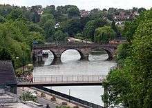
- Welsh Bridge (pictured) – in the centre of Shrewsbury, built in 1795 at a cost of £8,000
- English Bridge – also in Shrewsbury, designed and completed in 1774 by John Gwynn
- Atcham Bridges – the old one built in 1774, while the newer one in 1929 carries the B4380
- Albert Edward Bridge – in Coalbrookdale, a railway bridge opened in 1864
- Coalport Bridge – like its neighbour Ironbridge, is made of cast iron, built in 1818
- Victoria Bridge – designed by John Fowler, opened in 1862. Still in use by the Severn Valley Railway
- Bewdley Bridge – designed by Telford, completed in 1798
- Holt Fleet Bridge – in Worcestershire and designed by Telford and opened in 1828
- Upton Town Bridge – built in 1940, the only bridge to cross between Worcester and Tewkesbury
- Queenshill Viaduct – carries the M50 between Junction 1 and 2
- Mythe Bridge – designed by Telford and opened in April 1826, located in Tewkesbury
- Haw Bridge – a steel beam bridge, west of Tewkesbury
- Maisemore Bridge – carries the A417 and is a single masonry arch, dating back to 1230.
- Over Bridge – single masonry arch, built by Telford
- Over Rail Bridge – carrying the Gloucester to Newport Line, currently the last bridge before the Severn Crossings, which is 30 miles (48 km) downstream
- Severn Rail Bridge – linking the Forest of Dean to Sharpness docks, partially collapsed in 1960 and was dismantled in 1967–70
Rail
The Severn Tunnel, completed in 1886 by John Hawkshaw on behalf of the Great Western Railway, lies near the Second Severn Crossing road bridge, and carries the South Wales Main Line section of the Great Western Main Line under the channel. The original line built before the Severn Tunnel was the South Wales Railway from Gloucester, that followed the estuary alongside present day stations of Lydney, Chepstow, Caldicot and Severn Tunnel Junction to Newport.
Cars could also be transported through the Severn Tunnel. In the 1950s three trains a day made round trips between Severn Tunnel Junction and Pilning. The vehicles were loaded onto open flat bed carriages and pulled by a small pannier tank locomotive, although sometimes they were joined to a scheduled passenger train. The prudent owner paid to cover the vehicle with a sheet, as sparks often flew when the steam locomotive tackled the slope leading to the tunnel exit. A railway coach was provided for passengers and drivers. Reservations could be made and the fee for the car was about thirty shillings (£1.50) in the early 1950s.
Disasters
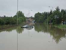
There have been many disasters on the Severn, which have claimed perhaps 300 lives, depending on sources, especially during the 20th century. The Severn Railway Bridge was badly damaged by the collision of two river barges in 1960, which led to its demolition in 1970. Five crew members of both the Arkendale H and Wastdale H died in the accident.[14] More recently the river flooded during the 2007 United Kingdom floods and the 2019–20 United Kingdom floods.
Navigation
There is a public right of navigation between Pool Quay, near Welshpool, and Stourport. However this stretch of the river has little traffic, other than small boats, canoes and some tour boats in Shrewsbury. Below Stourport, where the river is more navigable for larger craft, users must obtain permits from the Canal & River Trust, who are the navigation authority. During spring freshet the river can be closed to navigation.
At Upper Parting above Gloucester, the river divides into two, and flows either side of Alney Island to Lower Parting. The West Channel is no longer navigable. The East Channel is navigable as far as Gloucester Docks, from where the Gloucester and Sharpness Canal provides a navigable channel south. Between the docks and Lower Parting Llanthony Weir marks the Normal Tidal Limit (NTL) of the East Channel of the river.[15]
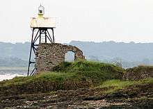
In the tidal section of the river below Gloucester, the Gloucester Harbour Trustees are the competent harbour authority. The Trustees maintain navigation lights at various points along the river (including on Chapel Rock and Lyde Rock, and leading lights at Slime Road, Sheperdine and Berkeley Pill).
Locks
There are locks on the lower Severn to enable seagoing boats to reach as far as Stourport. The most northerly lock is at Lincombe, about 1 mile (1.6 km) downstream from Stourport.
Associated canals
River Severn | |||||||||||||||||||||||||||||||||||||||||||||||||||||||||||||||||||||||||||||||||||||||||||||||||||||||||||||||||||||||||||||||||||||||||||||||||||||||||||||||||||||||||||||||||||||||||||||||||||||||||||||||||||||||||||||||||||||||||||||||||||||||||||||||||||||||||||||||||||||||||||||||||||||||||||||||||||||||||||||||||||||||||||||||||||||||||||||||||||||||||||||||||||||||||||||||||||||||||||||||||||||||||||||||||||||||||||
|---|---|---|---|---|---|---|---|---|---|---|---|---|---|---|---|---|---|---|---|---|---|---|---|---|---|---|---|---|---|---|---|---|---|---|---|---|---|---|---|---|---|---|---|---|---|---|---|---|---|---|---|---|---|---|---|---|---|---|---|---|---|---|---|---|---|---|---|---|---|---|---|---|---|---|---|---|---|---|---|---|---|---|---|---|---|---|---|---|---|---|---|---|---|---|---|---|---|---|---|---|---|---|---|---|---|---|---|---|---|---|---|---|---|---|---|---|---|---|---|---|---|---|---|---|---|---|---|---|---|---|---|---|---|---|---|---|---|---|---|---|---|---|---|---|---|---|---|---|---|---|---|---|---|---|---|---|---|---|---|---|---|---|---|---|---|---|---|---|---|---|---|---|---|---|---|---|---|---|---|---|---|---|---|---|---|---|---|---|---|---|---|---|---|---|---|---|---|---|---|---|---|---|---|---|---|---|---|---|---|---|---|---|---|---|---|---|---|---|---|---|---|---|---|---|---|---|---|---|---|---|---|---|---|---|---|---|---|---|---|---|---|---|---|---|---|---|---|---|---|---|---|---|---|---|---|---|---|---|---|---|---|---|---|---|---|---|---|---|---|---|---|---|---|---|---|---|---|---|---|---|---|---|---|---|---|---|---|---|---|---|---|---|---|---|---|---|---|---|---|---|---|---|---|---|---|---|---|---|---|---|---|---|---|---|---|---|---|---|---|---|---|---|---|---|---|---|---|---|---|---|---|---|---|---|---|---|---|---|---|---|---|---|---|---|---|---|---|---|---|---|---|---|---|---|---|---|---|---|---|---|---|---|---|---|---|---|---|---|---|---|---|---|---|---|---|---|---|---|---|---|---|---|---|---|---|---|---|---|---|---|---|---|---|---|---|---|---|---|---|---|---|---|---|---|---|---|---|---|---|---|---|---|---|---|---|---|---|---|---|---|---|---|---|---|---|---|---|
| |||||||||||||||||||||||||||||||||||||||||||||||||||||||||||||||||||||||||||||||||||||||||||||||||||||||||||||||||||||||||||||||||||||||||||||||||||||||||||||||||||||||||||||||||||||||||||||||||||||||||||||||||||||||||||||||||||||||||||||||||||||||||||||||||||||||||||||||||||||||||||||||||||||||||||||||||||||||||||||||||||||||||||||||||||||||||||||||||||||||||||||||||||||||||||||||||||||||||||||||||||||||||||||||||||||||||||
The Staffordshire and Worcestershire Canal, the Worcester and Birmingham Canal, (both narrow beam) and the Herefordshire and Gloucestershire Canal join the Severn at Stourport, Worcester and Gloucester respectively. The Droitwich Barge Canal, a broad beam canal, joins the Severn at Hawford, near to the River Salwarpe, and connects to the Droitwich Canal (narrow beam) in the name town, which then forms a link to the Worcester and Birmingham Canal. The two Droitwich canals re-opened in 2010 after major restoration.
The Gloucester and Sharpness Canal connects the Severn at Gloucester to the Severn at Sharpness, avoiding a stretch of the tidal river which is dangerous to navigate. The Stroudwater Navigation used to join the tidal Severn at Framilode, but since the 1920s has connected to the Severn only via the Gloucester and Sharpness Canal.
The Lydney Canal is a short canal which connects Lydney to the river.
The section of the river between Tewkesbury and Worcester forms part of the Avon Ring, a 109-mile (175 km) circular cruising route which includes 129 locks and covers parts of three other waterways.
Passenger transport
The tidal river
Paddle steamers were operated in the Severn Estuary from the mid 19th century to the late 1970s by P & A Campbell of Bristol. The vessels, Cardiff Queen, Bristol Queen, Glen Usk, Glen Gower and Britannia all operated on this route in the 1950s and 1960s. Since 1986 Waverley Excursions has operated occasional sailings to Sharpness and Lydney by the MV Balmoral.[16]
A number of ferries were also operated on the tidal river, for example at New Passage, Purton and Arlingham. The last ferry was the Aust Ferry, which closed in 1966 when the Severn Bridge opened. One of the Aust ferries, Severn Princess, is still in Chepstow although largely derelict.
The upper river
In Worcester, the Worcester River Cruises have boat trips up and down the river between Tewkesbury and Stourport, operating the boats The Pride of the Midlands and The Earl Grosvenor.[17]
The Cathedral Ferry, a foot passenger ferry, also operates on summer weekends from the steps of Worcester Cathedral.[18]
In Shropshire the Hampton Loade Ferry operated across the river though it has not been run recently (as of 2017) prompting speculation that it is permanently closed. This has not been confirmed by any reliable news sources but according to the nearby Severn Valley Railway it has ceased operation.[19]
In Shrewsbury, boat trips around the loop of the town centre are at present provided by the Sabrina and depart from Victoria Quay near the Welsh Bridge during the summer.[20]
Severn Estuary
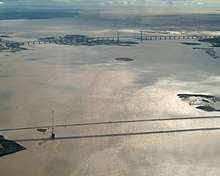
The river becomes tidal close to Maisemore, on the West Channel just north of Gloucester, and at Llanthony Weir on the East Channel. The tidal river downstream from Gloucester is sometimes referred to as the Severn Estuary, but the river is usually considered to become the Severn Estuary after the Second Severn Crossing near Severn Beach, South Gloucestershire (the point to which the jurisdiction of the Gloucester Harbour Trustees extends), or at Aust, the site of the Severn Bridge.
The Severn Estuary extends to a line from Lavernock Point (south of Cardiff) to Sand Point near Weston-super-Mare. West of this line is the Bristol Channel. In the Severn Estuary (or the Bristol Channel in the last two cases, depending where the boundary is drawn) are the rocky islands called Denny Island, Steep Holm and Flat Holm.
The estuary is about 2 miles (3 km) wide at Aust, and about 9 miles (14 km) wide between Cardiff and Weston-super-Mare.
Severn Sea
Until Tudor times the Bristol Channel was known as the Severn Sea, and it is still known as this in both Welsh and Cornish (Môr Hafren and Mor Havren respectively, with Môr meaning Sea).
Severn bore
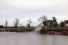
A phenomenon associated with the lower reaches of the Severn is the tidal bore,[21] which forms upstream of the port of Sharpness.
It is frequently asserted that the river's estuary, which empties into the Bristol Channel, has the second largest tidal range in the world—48 feet (15 m),[22][23] exceeded only by the Bay of Fundy. However a tidal range greater than that of the Severn is recorded from the lesser known Ungava Bay in Canada.[24] During the highest tides, the rising water is funnelled up the Severn estuary into a wave that travels rapidly upstream against the river current. The largest bores occur in spring, but smaller ones can be seen throughout the year. The bore is accompanied by a rapid rise in water level which continues for about one and a half hours after the bore has passed.
Industry
A 3-mile (4.8 km) stretch of the River Severn in Shropshire, is known as Ironbridge Gorge. It was designated a World Heritage Site by UNESCO in 1986. Its historic importance is due to its role as the centre of the iron industry in the early stages of the Industrial Revolution. The gorge and the village of Ironbridge get their name from the Iron Bridge across the Severn, built in 1779, which was the first cast-iron arch bridge ever constructed.[25]
Two nuclear power stations are situated on the river, in the area of South Gloucestershire. Oldbury Nuclear Power Station and Berkeley Nuclear Power Station both made use of the River Severn as part of the power generation and nuclear cooling processes. Both are now decommissioned.[26]
Wildlife
The sides of the estuary are also important feeding grounds for waders, notably at the Bridgwater Bay National Nature Reserve and the Slimbridge Wildfowl Trust. River shingle habitat can also be found on the lower estuary, notable for its population of the endangered 5-spot Ladybird.[27]
The river forms part of the Severn-Trent flyway, a route used by migratory birds to cross Great Britain.[28]
Literary and musical allusions
The River Severn is named several times in A.E. Housman's A Shropshire Lad (1896): "It dawns in Asia, tombstones show/And Shropshire names are read;/And the Nile spills his overflow/Beside the Severn's dead" (“1887"); "Severn stream" (“The Welsh Marches"); and "Severn shore" (“Westward from the high-hilled plain...”).
In William Shakespeare's Henry IV, Part 1, Henry Hotspur Percy recalls the valour of Edmund Mortimer, 5th Earl of March in a long battle against Welshman Owain Glyndŵr upon the Severn's banks, claiming the flooding Severn "affrighted with (the warriors') bloody looks ran fearfully among the trembling reeds and hid his crisp head in the hollow bank, bloodstained with these valiant combatants."
The Severn was the inspiration for a number of works by Gloucestershire composer Ivor Gurney, including the songs "Western Sailors" (1925) and "Severn Meadows" (1917).
Gloucestershire writer and poet Brian Waters published Severn Tide with J. M. Dent in 1947 and followed it with Severn Stream in 1949. With anecdotal stories about his travels, both books tell of the lives of the people who lived and worked on and along the river, describing the landscape with a poet's eye. Waters links Nodens with the Seven Bore and the association of the Celtic deity with the river is explored at length by Rogers.[9]
Several 20th-century English composers wrote works inspired by the river. Gerald Finzi (1901-1956) wrote A Severn Rhapsody, his Opus 3, in 1923; taking the Severn River and its surrounding countryside as his inspiration. Edward Elgar (1857-1934) wrote The Severn Suite, Opus 87, in 1930. Elgar lived much of both his early life and his later life near Worcester, through which the Severn runs. Herbert Howells (1892-1983), born close to the Severn in Lydney, wrote the complex Missa Sabrinensis (Mass of the Severn) in 1954, and an earlier hymn tune simply entitled Severn.
The Severn is often mentioned in Ellis Peters' The Cadfael Chronicles, set in or around Shrewsbury Abbey, beside the river.
In Julian Barnes' 2011 novel, The Sense of an Ending, Tony, the main character, recalls "a river rushing nonsensically upstream, its wave and wash lit by half a dozen chasing torchbeams," an allusion to a visit to the Severn Bore.
See also
- List of crossings of the River Severn
- Rivers of the United Kingdom
- The Severn Way long-distance footpath
- The Severn Area Rescue Association operates search and rescue services and lifeboats from Wyre Forest to Beachley (4 stations on the river)
- Mercia Inshore Search and Rescue are based at Upton-upon-Severn
- The Severn Valley, an area straddling Shropshire and Worcestershire
- Severnside, a term with various uses
- Seven Natural Wonders – 2005 TV programme where the river was described as one of the wonders of the West Country.
- Stourport Ring
- South Herefordshire and Over Severn - National Character Area
References
- "National River Flow Archive – 54001 Severn @ Bewdley". Archived from the original on 23 October 2007. Retrieved 24 January 2008.
- "HiFlows-UK". Archived from the original on 9 January 2007. Retrieved 24 January 2008.
- "National River Flow Archive – 54001 Severn @ Montford". Archived from the original on 23 October 2007. Retrieved 24 January 2008.
- "Frankwell Flood Alleviation Scheme, Shrewsbury" (PDF). UK Environment Agency. Retrieved 13 March 2010.
- "The River Severn Facts". BBC. Retrieved 28 December 2006.
- https://en.wiktionary.org/wiki/Reconstruction:Proto-Celtic/Sabrin%C4%81#Etymology Etymology of Hafren
- https://en.wiktionary.org/wiki/Reconstruction:Proto-Celtic/Sabrin%C4%81#Etymology
- Andy Morrall. "The Legend of Sabrina". Archived from the original on 24 October 2009. Retrieved 9 December 2006.CS1 maint: unfit url (link)
- Liam Rogers. "Sabrina and the River Severn". Retrieved 9 December 2006.
- "Statues of famous Salopians unveiled in Shrewsbury". Shropshire Star. 26 June 2013.
- Clucas, P. (1985). Britain – The Landscape Below. Guildford: Colour Library Books. ISBN 0-86283-174-1.
- "Glaciation and drainage evolution in the southern Welsh Borderland". Proceedings of the Shropshire Geological Society. Shropshire Geological Society. 13: 92−99. CiteSeerX 10.1.1.616.8048. ISSN 1750-855X.
- "The Ice Age Legacy in North Shropshire" (PDF). Proceedings of the Shropshire Geological Society. Shropshire Geological Society. 13: 86−91. 2008.
- Ron Huxley, The Rise and Fall of the Severn Bridge Railway, 1984, ISBN 978-1-84868-033-3
- "OS Maps - online and App mapping system - Ordnance Survey Shop".
- Waverley Excursions website Archived 4 August 2009 at the Wayback Machine
- Worcester River Cruises website Archived 8 July 2009 at the Wayback Machine
- Pryce, Mike (22 June 2019). "NOSTALGIA: Worcester's Cathedral Ferry is a Severn tradition". Worcester News. Retrieved 27 October 2019.
- "Hampton Loade Station". Severn Valley Railway. Retrieved 6 July 2017.
- "shrewsburyboat.co.uk".
- Rowbotham, Fred (1983) [1964]. Severn Bore. David & Charles. ISBN 0-7153-8508-9.
- "About the Severn Estuary". UK Environment Agency. 5 March 2006. Archived from the original on 5 February 2009. Retrieved 13 March 2010.
- "Coast: Bristol Channel". BBC. Retrieved 27 August 2007.
- "Frequently Asked Questions – Tide Predictions and Data". Co-ops.nos.noaa.gov. Retrieved 28 May 2013.
- Centre, UNESCO World Heritage. "Ironbridge Gorge".
- "Berkeley named as preferred nuclear waste site". BBC. 3 December 2013. Retrieved 4 December 2013.
- "Wales Online". Retrieved 26 September 2014.
- RSPB Where To Go Wild in Britain. Dorling Kindersley. 2009. p. 265. ISBN 978-1405335126.
External links
| Wikimedia Commons has media related to River Severn. |
- Severn Estuary Partnership
- Portishead and Bristol Lifeboat
- ITV Local footage ITV's Keith Wilkinson and Jennifer Binns canoeing the Severn
- Woodend, a hamlet washed away by the River Severn
- Canal & River Trust official site
| Authority control |
|
|---|