River Dee, Aberdeenshire
The River Dee (Scottish Gaelic: Uisge Dhè) is a river in Aberdeenshire, Scotland. It rises in the Cairngorms and flows through southern Aberdeenshire to reach the North Sea at Aberdeen.[3] The area it passes through is known as Deeside, or Royal Deeside in the region between Braemar and Banchory because Queen Victoria came for a visit there in 1848 and fell in love the place. She and her husband, Prince Albert, replaced an old castle there and built Balmoral Castle.[4]
| River Dee | |
|---|---|
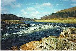 The River Dee at Potarch, between Aboyne and Banchory. | |
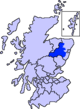
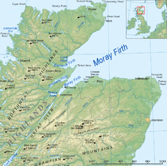 The north east of Scotland, showing the location of the Dee. | |
| Native name | Uisge Dhè |
| Location | |
| Country | Scotland |
| County | Aberdeenshire |
| Physical characteristics | |
| Source | |
| ⁃ location | Wells of Dee, Braeriach, Cairngorms |
| ⁃ elevation | 1,220[1] m (4,000 ft) |
| Mouth | |
⁃ location | Aberdeen |
⁃ coordinates | 57°08′32″N 2°04′02″W |
| Length | 140 km (87 mi) |
| Basin size | 2,100 km2 (810 sq mi) |
| Discharge | |
| ⁃ location | Aberdeen |
| Notes:[2] | |
Deeside is a popular area for tourists, due to the combination of scenic beauty and historic and royal associations.[4] The scenic beauty of Deeside is recognised by its inclusion in the Cairngorms National Park and the Deeside and Lochnagar National Scenic Area.[5] The Dee is popular with anglers, and is one of the most famous salmon fishing rivers in the world.[6]
The New Statistical Account of Scotland attributed the name Dee as having been used as early as the second century AD in the work of the Alexandrian geographer Claudius Ptolemy, as Δηοῦα (=Deva), meaning 'Goddess', indicating a divine status for the river in the beliefs of the ancient inhabitants of the area. There are several other rivers of the same name in Great Britain, and these are believed to have similar derivations,[7] as may the Dee's near neighbour to the north, the River Don.
Geography
Upper reaches
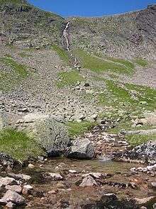
The River Dee rises from a spring on the Braeriach plateau in the Cairngorm Mountains at a height of at about 1,220 m,[1] the highest source of any major river in the British Isles.[2] Emerging in a number of pools called the Wells of Dee the young Dee then flows across the plateau to the cliff edge from where the Falls of Dee plunge into An Garbh Choire ("burn of the rough corrie"[8]).[9] The river is then joined by a tributary coming from the Pools of Dee in the Lairig Ghru, and flows south down the Lairig Ghru between Ben Macdui and Cairn Toul, tumbling over falls in the Chest of Dee on its way to White Bridge and the confluence with the Geldie Burn, at which point it turns east.[9]
Linn of Dee
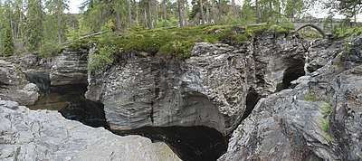
At Linn of Dee the river passes east through a 300 metre natural rock gorge,[3] a spot much favoured by Queen Victoria during her stays at Balmoral. The queen opened the bridge that spans the Dee at this point in 1857.[10] Between Linn of Dee and Braemar the Lui Water (formed by the Luibeg and Derry burns) and the Quoich Water join the growing River Dee. The River Clunie enters the Dee at Braemar.[9] Evidence for human activity stretching as far back as c8,200 BC has been found at a complex of sites stretching along the banks of the Dee.
Strathdee
Through Deeside the river passes Braemar, Balmoral Castle, Ballater, Dinnet, Aboyne and Banchory to reach the sea at Aberdeen. Near Ballater two rivers are tributaries: the River Gairn flowing from the north and the River Muick, flowing out of Loch Muick, from the south. The river remains within the Cairngorms National Park until it reaches Dinnett. Water of Tanar flows through Glen Tanar before joining at Aboyne. The Falls of Feugh has its confluence with the Dee at Banchory and Coy Burn enters at Milton of Crathes.[9][11]
The tidal limit is just above Bridge of Dee, built about 1720, which carries the main A90 trunk road from Aberdeen to the south.[12] Before reaching the North Sea, the river passes through Aberdeen Harbour, the principal marine centre for the energy industry in Europe, servicing the offshore oil and gas industry.[13] An artificial channel was constructed in 1872 to straighten the river's flow into the sea. Footdee ("Fittie") is an old fishing village at the east end of Aberdeen Harbour.
Nature and conservation
| Deeside and Lochnagar National Scenic Area | |
|---|---|
 Caledonian pine forest, Glen Tanar | |
| Location | Aberdeenshire, Scotland |
| Area | 398 km2 (154 sq mi)[14] |
| Established | 1981 |
| Governing body | Scottish Natural Heritage |
The Dee is important for nature conservation and the area has many designated sites.[5] The upper catchment down to Inverey is within the Mar Lodge Estate, which is owned by the National Trust for Scotland and has been classified as a National Nature Reserve since May 2017.[15]
The Cairngorms National Park, established in 2003[16] covers the whole of the catchment of the Dee, including tributaries, down to as far as Dinnet.[5] As well being included as part of the Cairngorms National Park the Deeside area, along with the mountains surrounding Lochnagar as far south as the head of Glen Doll, are together classified as the Deeside and Lochnagar National Scenic Area, one of 40 such areas in Scotland.[17] The designated national scenic area covers 39,787 ha,[18] extending from the Geldie down to Ballater.[19]
The entire length of the Dee is defined as a Special Area of Conservation (SAC) due to its importance for salmon, otters and Freshwater pearl mussels.[20] Other SACs within the Deeside area include Glen Tanar, the Muir of Dinnet, Ballochbuie and the Morrone Birkwood.[5] The southern side of Deeside is classified as a Special Protection Area, due to the area's importance for golden eagles.[21]
Much of the semi-natural Caledonian pine forest in Scotland is within the Dee catchment. The area contains nationally rare examples of pine woods, birch woods and heather moors with associated wildlife. On the valley floor there are deciduous alder and mixed broadleaved woods, and meadow grasslands.[22]
The Dee is a popular salmon river, having a succession of varied pools, intersected by sharp rapids.[6] In 1995 it was estimated that salmon fishing on the river contributed between £5 and £6 million a year to the Grampian Region economy.[23]
Transport on Deeside
The A93 road runs west along the north bank of the river from Aberdeen to Braemar before it turns south, leaving Deeside, to climb to the Glenshee Ski Centre at Cairnwell Pass and then onwards to Perth.[9] Just west of Ballater the A939 Lecht Road leaves the A93 to take a tortuous climb towards the Lecht Ski Centre then on to Tomintoul and eventually Nairn. Beyond Braemar a narrow road continues along the south side of the Dee as far as Linn of Dee, at which point it doubles back to terminate at Linn of Quioch on the north bank of the Dee. There are no paved roads into the Cairngorms beyond Linn of Dee, although two walking routes, the Lairig Ghru and the Lairig an Laoigh, continue via passes in the mountains to reach Speyside.[9]
Until 1966 the Deeside Railway ran from Aberdeen to Ballater, operated by the Great North of Scotland Railway.[24] The line opened from Aberdeen to Banchory in 1853,[25] was extended to Aboyne in 1859,[26] with a further extension to Ballater opening in 1866.[27] The line was not extended beyond Ballater to Braemar as this would require running close to Balmoral, leading to objections from Queen Victoria. The Royal Family used Ballater Station when visiting Balmoral,[28] and the station was converted into a rail museum after the closure of the line, but was destroyed by fire in 2015.[27] A very short section of the line near Milton of Crathes has been restored as a heritage railway, named the Royal Deeside Railway.[29]
Royal Deeside
The area around Braemar and Ballater is known as Royal Deeside by some people, and this usage has been encouraged by the tourist trade.[4] Since the reign of Queen Victoria the British Royal Family have spent their summers at Balmoral Castle. Every year they attend the Braemar Highland Gathering and other local events.[30] Birkhall, previously owned by Queen Elizabeth the Queen Mother, is now a favourite retreat of Prince Charles.[31]
Gallery
 Wells of Dee on Braeriach.
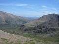 Cairn Toul & Ben Macdui.
 The Linn of Dee.
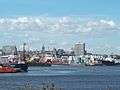 Aberdeen Harbour, at the estuary of the River Dee.
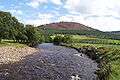 The River Clunie near Braemar.
 Balmoral Castle in Royal Deeside (photochrom from about 1900).
References
- Watson, Adam (1975). The Cairngorms. Edinburgh: The Scottish Mountaineering Trust.
- Scottish Environment Protection Agency and www.theriverdee.org (2007). "The River Dee Catchment Management Plan: Issues Consultation Document" (PDF). Archived from the original (pdf) on 21 March 2012. Retrieved 9 March 2011.
- Chisholm, Hugh, ed. (1911). . Encyclopædia Britannica. 7 (11th ed.). Cambridge University Press. p. 921.
- "Royal Deeside". Visit Scotland. Retrieved 7 February 2018.
- "Sitelink - Map Search". Scottish Natural Heritage. Retrieved 19 February 2018.
- "River Dee - Angling". River Dee Trust. Retrieved 7 February 2018.
- "The New Statistical Account of Scotland, pp. 3-4". William Blackwood and Sons. 1845. Retrieved 28 February 2018.
- Anderson, Robert (1911), Deeside, Adam & Charles Black, 4 Soho Square, London
- Ordnance Survey Landranger 1:50000, Sheet 43
- "Linn o' Dee history, tourist information, and nearby accommodation". Britain Express. Retrieved 28 February 2018.
- Ordnance Survey Landranger 1:50000, Sheet 44
- Stapleton, C.; Pethick, J. (1996). Review 52. Coastal processes and management of the Scottish Estuaries. III. The Dee, Don and Ythan Estuaries (PDF). Scottish Natural Heritage. p. 19.
- "Aberdeen Harbour". Aberdeen Harbour Board. Archived from the original on 29 May 2014. Retrieved 9 November 2013.
- "National Scenic Areas - Maps". SNH. 20 December 2010. Retrieved 28 March 2018.
- "Scotland's Newest National Nature Reserves". National Trust for Scotland. 17 April 2017. Retrieved 7 February 2018.
- "History Leading to the Cairngorms National Park". Cairngorms National Park Authority. Retrieved 27 February 2018.
- "National Scenic Areas". Scottish Natural Heritage. Retrieved 17 January 2018.
- "National Scenic Areas - Maps". SNH. 20 December 2010. Retrieved 28 February 2018.
- "Map: Deeside and Lochnagar National Scenic Area" (PDF). Scottish Natural Heritage. 20 December 2010. Retrieved 28 February 2018.
- "Site Details for River Dee". Scottish Natural Heritage. 1 February 2018. Retrieved 28 February 2018.
- "Site Details for Cairngorms Massif". Scottish Natural Heritage. 1 February 2018. Retrieved 28 February 2018.
- "Caledonian Pinewood Inventory". Forestry Commission Scotland. 24 June 2016. Retrieved 28 February 2018.
- Scottish Office (1997). Report of the Scottish Salmon Strategy Task Force. Edinburgh: Scottish Office.
- British Railways Pre-grouping Atlas and Gazetteer. Ian Allan publishing, 1958/2004.
- "Deeside Railway". Railscot. 7 September 2011. Retrieved 28 February 2018.
- "Deeside Extension Railway". Railscot. 7 September 2011. Retrieved 28 February 2018.
- "Royal station in Ballater destroyed by fire". BBC News. 12 May 2015. Retrieved 28 February 2018.
- "Aboyne and Braemar Railway". Railscot. 7 August 2011. Retrieved 28 February 2018.
- "Royal Deeside Railway". 2017. Retrieved 28 February 2018.
- "The Queen, Prince Philip and Prince Charles attend the Braemar Gathering". News: NE Scotland, Orkney & Shetland. BBC. Retrieved 9 November 2013.
- Grice, Elizabeth (9 April 2005). "Alone at last (with just a few house guests)". Telegraph. Retrieved 9 November 2013.
External links
| Wikimedia Commons has media related to River Dee, Aberdeenshire. |
- River Dee Trust & Dee District Salmon Fishery Board
- Banchory.org — Banchory & District Initiatives Ltd website
- Discovering Deeside
Settlements and places of interest in Marr, Aberdeenshire | ||
|---|---|---|
| Primary settlements |
|  |
| Other settlements |
| |
| Places of interest |
| |