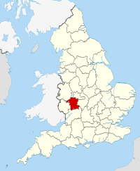
Worcestershire
Worcestershire (/ˈwʊstərʃər/ (![]()
| Worcestershire | |||||
|---|---|---|---|---|---|
| Ceremonial county | |||||
| |||||
 | |||||
| Sovereign state | United Kingdom | ||||
| Constituent country | England | ||||
| Region | West Midlands | ||||
| Established | 1 April 1998 | ||||
| Established by | Local Government Commission for England | ||||
| Preceded by | Hereford and Worcester | ||||
| Origin | Ancient | ||||
| Ceremonial county | |||||
| High Sheriff | Edward Holloway[1] (2019–2020) | ||||
| Area | 1,741 km2 (672 sq mi) | ||||
| • Ranked | 34th of 48 | ||||
| Population (mid-2018 est.) | 592,057 | ||||
| • Ranked | 38th of 48 | ||||
| Density | 340/km2 (880/sq mi) | ||||
| Ethnicity | 92.4% White British 3.4% White Other 2.4% Asian 0.4% Black 1.4% Other/Mixed[2] | ||||
| Non-metropolitan county | |||||
| County council | Worcestershire County Council[3] | ||||
| Executive | Conservative | ||||
| Admin HQ | Worcester | ||||
| Area | 1,741 km2 (672 sq mi) | ||||
| • Ranked | 22nd of 26 | ||||
| Population | 592,057 | ||||
| • Ranked | 21st of 26 | ||||
| Density | 340/km2 (880/sq mi) | ||||
| ISO 3166-2 | GB-WOR | ||||
| ONS code | 47 | ||||
| NUTS | UKG12 | ||||
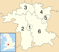 Districts of Worcestershire | |||||
| Districts |
| ||||
| Members of Parliament | |||||
| Time zone | Greenwich Mean Time (UTC) | ||||
| • Summer (DST) | British Summer Time (UTC+1) | ||||
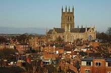
The cathedral city of Worcester is the largest settlement and county town. Other major towns in the county include Bromsgrove, Droitwich, Evesham, Kidderminster, Malvern, Redditch, and Stourport-on-Severn. The north-east of Worcestershire includes part of the industrial West Midlands; the rest of the county is largely rural. The county is divided into six administrative districts: Worcester, Redditch, Wychavon, Malvern Hills, Wyre Forest, and Bromsgrove.
The area that is now Worcestershire was absorbed into the unified Kingdom of England in 927, at which time it was constituted as a county (see History of Worcestershire). Over the centuries the county borders have been modified, but it was not until 1844 that substantial changes were made. This culminated with the abolition of Worcestershire in 1974 with its northern area becoming part of the West Midlands and the rest part of the county of Hereford and Worcester. However, in 1998 the county of Hereford and Worcester was abolished and Worcestershire was reconstituted without the northern area ceded to the West Midlands.
Location
The county borders Herefordshire to the west, Shropshire to the north-west, Staffordshire only just to the north, West Midlands to the north and north-east, Warwickshire to the east and Gloucestershire to the south. The western border with Herefordshire includes a stretch along the top of the Malvern Hills. At the southern border with Gloucestershire, Worcestershire meets the northern edge of the Cotswolds. Two major rivers flow through the county: the Severn and the Avon.
History

The geographical area now known as Worcestershire was first populated at least 700,000 years ago. The area became predominantly agricultural in the Bronze Age, leading to population growth and more evidence of settlement. By the Iron Age, hill forts dominated the landscape. Settlement of these swiftly ended with the Roman occupation of Britain.
The Roman period saw establishment of the villa system in the Cotswalds and Vale of Evesham. Droitwich (Salinae) was probably the most important settlement in the county in this period, due to its product of salt. There is also evidence for Roman settlement and industrial activity around Worcester and King's Norton.
Anglo-Saxon
Worcestershire was the heartland of the early English kingdom of the Hwicce. It was absorbed by the Kingdom of Mercia during the 7th century and became part of the unified Kingdom of England in 927. It was a separate ealdormanship briefly in the 10th century before forming part of the Earldom of Mercia in the 11th century. In the years leading up to the Norman conquest, the Church, supported by the cathedral, Evesham Abbey, Pershore Abbey, Malvern Priory, and other religious houses, increasingly dominated the county.
Medieval
During the Middle Ages, much of the county's economy was based on the wool trade. Many areas of its dense forests, such as Feckenham Forest, Horewell Forest and Malvern Chase, were royal hunting grounds subject to forest law.
The last known Anglo-Saxon sheriff of the county was Cyneweard of Laughern, and the first Norman sheriff was Urse d'Abetot who built the castle of Worcester and seized much church land.
On 4 August 1265, Simon de Montfort was killed in the Battle of Evesham in Worcestershire.
Civil War
In 1642, the Battle of Powick Bridge was the first major skirmish of the English Civil War. The county suffered from being on the Royalist front line, as it was subject to heavy taxation and the pressing of men into the Royalist army, which also reduced its productive capacity. The northern part of the county, which was already a centre of iron production, was important for military supplies. Parliamentarian raids and Royalist requisitioning both placed a great strain on the county.
There were tensions from the participation of prominent Catholic recusants in the military and civilian organisation of the county. Combined with the opposition to requisitioning from both sides, bands of Clubmen formed to keep the war away from their localities.
The Battle of Worcester in 1651 effectively ended the third civil war. There was little enthusiasm or local participation in the mostly Scottish Royalist army, whose defeat was widely welcomed. Nevertheless, Parliamentarian forces ransacked the city of Worcester, causing heavy damage, looting and destruction of property. Around 10,000 mostly Scottish prisoners were sent into forced labour in the New World or fen drainage schemes. The small bands of Scots that fled into Worcestershire's countryside were attacked by local forces and killed.
Nineteenth century
In the 19th century, Worcester was a centre for the manufacture of gloves; the town of Kidderminster became a centre for carpet manufacture, and Redditch specialised in the manufacture of needles, springs and hooks. Droitwich Spa, situated on large deposits of salt, was a centre of salt production from Roman times, with one of the principal Roman roads running through the town. These old industries have since declined, to be replaced by other, more varied light industry. The county is also home to the world's oldest continually published newspaper, the Berrow's Journal, established in 1690. Malvern was one of the centres of the 19th-century rise in English spa towns due to Malvern water being believed to be very pure, containing "nothing at all".[4]
Demographics
The 2011 census found the population of Worcestershire to be 566,169, an increase of 4.4% from the 2001 population of 542,107.
Ethnicity
Though the total number of people in every ethnic group increased between 2001–11, the White British share of Worcestershire's population decreased from 95.5% to 92.4%, as did the share of White ethnic groups as whole, which went from 97.5% to 95.7%. Worcestershire is still much more ethnically homogeneous than the national average. In 2011, 79.8% of the population of England identified as White British; much lower than Worcestershire's figure of 92.4%.[2]
| Ethnic group | 2001 population | 2001 % | 2011 population | 2011 % |
|---|---|---|---|---|
| White: British | 517,747 | 95.5 | 522,922 | 92.4 |
| White: Irish | 4,163 | 0.8 | 3,480 | 0.6 |
| White: Irish Traveller/Gypsy[note 1] | 1,165 | 0.2 | ||
| White: Other | 6,869 | 1.27 | 14,491 | 2.6 |
| White: Total | 528,779 | 97.5 | 542,058 |
95.7 |
| Asian or Asian British: Indian | 1,640 | 0.3 | 3,634 | 0.6 |
| Asian or Asian British: Pakistani | 2,917 | 0.5 | 4,984 | 0.9 |
| Asian or Asian British: Bangladeshi | 970 | 0.2 | 1,316 | 0.2 |
| Asian or Asian British: Chinese | 1,106 | 0.2 | 1,601 | 0.3 |
| Asian or Asian British: Asian Other | 455 | 0.1 | 2,206 | 0.4 |
| Asian or Asian British: Total | 7,088 | 1.3 | 13,741 | 2.4 |
| Black or Black British: Caribbean | 1,153 | 0.2 | 1,275 | 0.2 |
| Black or Black British: African | 332 | 0.1 | 767 | 0.1 |
| Black or Black British: Other | 153 | 0.03 | 330 | 0.1 |
| Black or Black British: Total | 1,638 | 0.3 | 2,372 |
0.4 |
| Mixed: White and Caribbean | 1,704 | 0.3 | 3,150 | 0.6 |
| Mixed: White and African | 221 | 0.04 | 592 | 0.1 |
| Mixed: White and Asian Other | 1,099 | 0.2 | 2,053 | 0.4 |
| Mixed: Other Mixed | 771 | 0.1 | 1,250 | 0.2 |
| British Mixed: Total | 3,795 | 0.7 | 7,045 |
1.2 |
| Other: Arab[note 2] | 236 | 0.04 | ||
| Other: Any other ethnic group | 807 | 0.1 | 717 | 0.1 |
| Other: Total | 807 | 0.1 | 953 |
0.2 |
| Total | 542,107 | 100 | 566,169 |
100 |
Local government
Local government in Worcestershire has changed several times since the middle of the 19th century.
1844–1911

Worcestershire had several exclaves, which were areas of land cut off from the main geographical area of Worcestershire and completely surrounded by the nearby counties of Warwickshire, Staffordshire, Gloucestershire, Herefordshire and Oxfordshire. The most notable were Dudley, Evenlode, and the area around Shipston-on-Stour. In return, Staffordshire, Warwickshire and Shropshire had their own exclaves within Worcestershire. These were found at Clent, Tardebigge and Halesowen/Oldbury (or the Halesowen parish area) and were transferred to or rejoined Worcestershire in October 1844 under the Counties (Detached Parts) Act 1844. This Act of Parliament was designed to eradicate the issue of 'islands' or 'exclaves', however Shipston-on-Stour remained associated with Worcestershire until April 1931 and likewise Dudley until 1966. The southern boundary of the county was also confusing, with parish boundaries penetrating deep into Gloucestershire and vice versa. This was also eventually resolved by the 1844 Act.
Worcestershire County Council came into existence following the Local Government Act 1888 and covered the historic traditional county, except for two designated county boroughs at Dudley and Worcester.
Birmingham's continuous expansion has been a major cause of Worcestershire's fluid boundary changes and associated housing issues. The district of Balsall Heath, which had originally constituted the most northerly part of the parish of King's Norton, was the first area of the county to be added to the County Borough of Birmingham, on 1 October 1891. This was followed by Quinton Urban District, which was ceded to Birmingham in November 1909, and then by the Rural District of Yardley and the greater part of the Urban District of King's Norton and Northfield, which were absorbed into Birmingham under the Greater Birmingham Scheme on 9 November 1911. Thus these areas were transferred from Worcestershire to Warwickshire. Dudley's historical status within the Diocese of Worcester and through its aristocratic links ensured that the exclave was governed on a largely autonomous basis. Worcester was also self-governing and was known as The City and County of Worcester.
1926 boundary changes
In 1926, Dudley County Borough council purchased several square miles of land to the north of the town centre, mostly in Sedgley (Staffordshire), including Dudley Castle. This was to build the Priory Estate, a large new council estate on which construction began in 1929. The boundaries of Worcestershire were altered to include all of the proposed new housing estate in Dudley.[5]
1966–1974
During the Local Government reorganisation of April 1966, Dudley expanded beyond its historical boundaries and took in the bulk of Sedgley and Brierley Hill and the south of Coseley as well as a small section of Amblecote. The Local Government Act redefined its status and the County Borough of Dudley became part of Staffordshire, the county of which all of these areas had been part. At the same time, Worcestershire gained a new county borough named Warley, which was an amalgamation of Oldbury Urban District, Rowley Regis Urban District, the County Borough of Smethwick and parts of Dudley and Tipton. During these reorganisations, the area of the administrative county grew only where Stourbridge took in the majority of Amblecote Urban District from Staffordshire and the designation of Redditch in 1964 as a New Town. This in turn saw expansion into the area in and around the villages of Ipsley and Matchborough in Warwickshire. The Redditch New Town designation coincided with a considerable programme of social and private house building in Droitwich, Worcester, Bromsgrove, Kidderminster and along the Birmingham boundary at Frankley, Rubery and Rednal. Frankley parish was later split into two: New Frankley and the area around Bartley Reservoir transferred from Bromsgrove District to Birmingham in April 1995; but the small village of Frankley remained in Worcestershire and became a new civil parish under the same name.
1974–1998
From 1974, the central and southern parts of the county were amalgamated with Herefordshire and with Worcester County Borough to form a single non-metropolitan county of Hereford and Worcester. The County Boroughs of Dudley and Warley, along with Stourbridge and Halesowen, were incorporated into the new West Midlands Metropolitan county. The West Midlands County Council existed for only a few years before abolition in April 1986, although the West Midlands still exists as a ceremonial county.
1998–present
In the 1990s UK local government reform, the county of Hereford & Worcester was abolished, and the non-metropolitan county or shire county of Worcestershire regained its historic border with Herefordshire. The recreated County of Worcestershire came into existence on 1 April 1998 as an administrative and ceremonial county, although this excluded the Black Country towns of Dudley, Halesowen, Oldbury and Stourbridge (which remained part of the West Midlands). Worcestershire County Council was reformed, although some services are shared with the newly formed Herefordshire Council, including waste management and the youth offending service.
The former Hereford and Worcester districts of Redditch, Worcester, Bromsgrove, Wychavon and Wyre Forest were retained with little or no change. However the Leominster and Malvern Hills districts straddled the historic border, so a new Malvern Hills district was constituted which straddled the pre-April 1974 county boundary to the west, south-west and north-west. The remaining parts of the former Hereford and Worcester district of Leominster, returned to Herefordshire.
Physical geography
The Malvern Hills, which run from the south of the county into Herefordshire, are made up mainly of volcanic igneous rocks and metamorphic rocks, some of which date from more than 1200 million years ago. They are designated as an Area of Outstanding Natural Beauty (AONB). The Worcestershire Beacon, which at 425m is the highest point in the county, lies in this range.[6]
The rest of the county consists of undulating hills and farmland stretching either side of the Severn valley. The Severn is the United Kingdom's longest river and flows through Bewdley, Stourport-on-Severn and Worcester.[7] The River Avon flows through the Worcestershire town on Evesham and joins the Severn at Tewkesbury, Gloucestershire.
Several coniferous and deciduous woodlands are located in the north of the county. The Vale of Evesham runs through the south of the county and to its south are the Cotswolds AONB.[8]
Green belt
Worcestershire contains a broad expanse of green belt area, widening to over 16 kilometres (9.9 mi) in places. It is part of the larger belt surrounding the West Midlands county, and first drawn up from the 1950s. All of the county's districts other than Malvern Hills contain some portion of the belt.
Sport
The largest and most successful football club in the county is Kidderminster Harriers. Founded in 1877 as a running club and doubling as a rugby club from 1880, the football club was founded in 1886. In 1987, the club won the FA Trophy for the first time, and seven years later reached the fifth round of the FA Cup, also winning the GM Vauxhall Conference title in 1994 but being denied Football League status as their Aggborough Stadium did not meet capacity requirements. However, when the club next won the Conference title six years later, their stadium had been upgraded and promotion was granted, giving the county its first (and thus far only) Football League members. However, the club's Football League membership was short-lived, as Harriers were relegated back to the Conference in 2005 after just five years in the Football League, and have yet to reclaim their status.[9]
The county is also represented by Alvechurch, Bromsgrove Sporting and Redditch United of the Southern Premier League, and Worcester City of the Midland Football League.
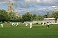
The county is home to Worcestershire County Cricket Club, traditionally first stop on for the touring national side's schedule in England.[10] Formed officially in 1865, the Club initially played in Boughton Park, before moving to its current New Road ground, which today can host 5,500 spectators, in 1895. The Club has won five County Championships in its history, most recently in 1989.[11]
Worcester Rugby Football Club, the Worcester Warriors, are the county's largest and most successful Rugby Union team, having been promoted to the Premiership in 2004. The Warriors were relegated to the RFU Championship in 2010 but rebounded back to the Premiership in 2011. Worcester Warriors play at the Sixways Stadium on the outskirts of Worcester, holding over 12,000 spectators, thus making it the largest stadium in the county. Sixways has hosted the final of the LV Cup on three occasions.[12]
Culture
The village of Broadheath, about 10 kilometres (6.2 mi) northwest of the city of Worcester, is the birthplace of the composer Edward Elgar.
It is claimed that the county was the inspiration for The Shire, a region of J. R. R. Tolkien's fictional Middle-earth, described in The Hobbit and The Lord of the Rings. Tolkien was thought to have named Bilbo Baggins' house "Bag End" after his Aunt Jane's Worcestershire farm. Tolkien wrote of Worcestershire, "Any corner of that county (however fair or squalid) is in an indefinable way 'home' to me, as no other part of the world is."[13]
Worcestershire is one of the three counties associated with the Border Morris style of English folk dancing. Worcestershire Monkey is a popular Border Morris dance; although normally performed as a group of eight, it is sometimes danced en masse with multiple Border Morris sides performing the dance together.[14]
Media
BBC Hereford & Worcester, Free Radio and Sunshine Radio broadcast to both Herefordshire and Worcestershire. Signal 107 broadcasts to the north west of Worcestershire. Youthcomm Radio, a Community radio station, broadcasts to the city of Worcester. Birmingham-based radio stations such as BBC Radio WM have traditionally considered the bordering areas of Worcestershire as part of their broadcast area. The Birmingham-based West Midlands regional stations, such as Heart and Smooth Radio regionals also cover much of the county.
In 2007 the Office of Communications (Ofcom) awarded a DAB Digital Radio multiplex licence for Herefordshire & Worcestershire to MuxCo Ltd. who aimed to provide several new stations in 2009, while also providing a digital platform for Free Radio, Sunshine Radio and BBC Hereford & Worcester and area extensions to United Christian Broadcasters and the Highways Agency. This multiplex eventually launched in December 2013, carrying the three aforementioned local services. In 2008, MXR, who owned and operated the West Midlands regional DAB multiplex licence, improved coverage of DAB Digital Radio across other parts of the county to include Worcester and Malvern. Services that could be heard reasonably across much of Worcestershire included: Chill, Gold (Birmingham), Magic, Sunrise Radio, Traffic Radio (Midlands), BBC Radio WM, Xfm and Radio XL. However, this regional multiplex closed on 27 August 2013, reducing the number of services available in the county.
Economy
This is a chart of trend of regional gross value added of Worcestershire at current basic prices published (pp. 240–253) by Office for National Statistics with figures in millions of British Pounds Sterling.
| Year | Regional Gross Value Added[15] | Agriculture[16] | Industry[17] | Services[18] |
|---|---|---|---|---|
| 1995 | 5,047 | 225 | 1,623 | 3,200 |
| 2000 | 6,679 | 159 | 2,002 | 4,518 |
| 2003 | 7,514 | 182 | 1,952 | 5,380 |
Industry and agriculture
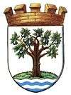
Fruit farming and the cultivation of hops were traditional agricultural activities in much of the county. During the latter half of the 20th century, this has largely declined with the exception southern area of the county around the Vale of Evesham, where orchards are still worked on a commercial scale. Worcester City's coat of arms includes three black pears, representing a now rare local pear variety, the Worcester Black Pear. The county's coat of arms follows this theme, having a pear tree with black pears. The apple variety known as Worcester Pearmain originates from Worcestershire, and the Pershore plum comes from the small Worcestershire town of that name, and is widely grown in that area.
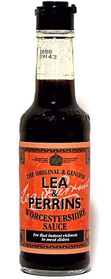
Worcestershire is also famous for a number of its non-agricultural products. The original Worcestershire sauce, a savoury condiment made by Lea and Perrins, is made in Worcester, and the now-closed Royal Porcelain works was based in the city. The town of Malvern is the home of the Morgan traditional sports car.
Education
Worcestershire has a comprehensive school system with over thirty-five independent schools including the RGS Worcester, The King's School, Worcester, Malvern St James and Malvern College. State schools in Worcester, the Wyre Forest District, and the Malvern Hills District are two-tier primary schools and secondary schools whilst Redditch and Bromsgrove have a three-tier system of first, middle and high schools. Several schools in the county provide Sixth-form education including two in the city of Worcester. Several vocational colleges provide GCSE and A-level courses and adult education, such as South Worcestershire College, and an agricultural campus of Warwickshire College in Pershore. There is also the University of Worcester, which is located in the city itself and is home to the National Pollen and Aerobiology Research Unit and five other national research centres.
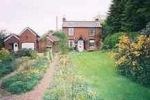
Towns and villages
The county town and only city is Worcester. The other major settlements, Kidderminster, Bromsgrove and Redditch are satellite towns of Birmingham. There are also several market towns: Malvern, Bewdley, Evesham, Droitwich Spa, Pershore, Tenbury Wells, Stourport-on-Severn and Upton-upon-Severn. The village of Hartlebury housed the Bishop of Worcester from the 13th century until 2007.
Places of interest
| Key | |
| Abbey/Priory/Cathedral | |
| Accessible open space | |
| Amusement/Theme Park | |
| Castle | |
| Country Park | |
| English Heritage | |
| Forestry Commission | |
| Heritage railway | |
| Historic House | |
| Mosques | |
| Museum (free/not free) | |
| National Trust | |
| Theatre | |
| Zoo | |
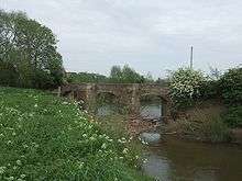
- Avoncroft Museum of Historic Buildings
.svg.png)
- Bewdley – riverside historic Tudor town
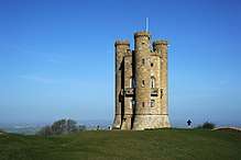
- Broadway – a picturesque Cotswold village
- Croome Court


- Elgar Birthplace Museum
- Forge Mill Needle Museum at Redditch, the only remaining working needle mill in the world.
- Great Malvern Priory

- Greyfriars' House and Garden
- Hanbury Hall
- Hartlebury Castle
- Harvington Hall
- Kemerton Court
- Malvern Hills – Area of Outstanding Natural Beauty

- Middle Littleton Tithe Barn – a restored 13th-century tithe barn
- Morgan Cars – visitors centre and museum
- Pershore Abbey
- River Severn at Worcester and Bewdley, River Avon at Pershore or Evesham
- River Teme and valley
- Severn Valley Railway at Kidderminster.

- Tenbury Wells with its unique Pump Rooms.
- The Commandery
- The Fleece Inn – an ancient public house, now owned by the National Trust
- The Hive, Worcester – the new University and public library (opened in 2012)
- Wadborough
- Walton Hill and the Clent Hills
- West Midlands Safari Park near Bewdley.
- Witley Court at Great Witley – a burnt-out shell of a large English stately home, famous for its gigantic fountain, now restored to working order. Currently run by English Heritage.

- Worcester and Birmingham Canal
- Worcester Cathedral
- Worcestershire County Museum
- Worcester City Art Gallery & Museum
- Worcester Porcelain Museum
Local groups
- Worcestershire Wildlife Trust
- 29th Regiment of Foot
- West Midland Bird Club
See also
- Healthcare in Worcestershire
- List of Lord Lieutenants of Worcestershire
- List of High Sheriffs of Worcestershire
- Custos Rotulorum of Worcestershire - List of Keepers of the Rolls
- Worcestershire (UK Parliament constituency) - Historical list of MPs for Worcestershire constituency
- Evolution of Worcestershire county boundaries
References
Notes
- In 2001 part of the White Other category. New category created for the 2011 census
- In 2001 part of the 'Other' category. New category created for the 2011 census
Citations
- "Privy Council Office-APPOINTMENT OF SHERIFFS". London Gazette. Retrieved 17 April 2019.
- "Census 2011:KS201EW Ethnic group, local authorities in England and Wales". ons.gov.uk. Office of National Statistics. Retrieved 9 December 2019.
- Worcestershire County Council. "Worcestershire County Council". Archived from the original on 21 November 2008.
- Bottled Waters of the World Archived 27 April 2009 at the Wayback Machine. Retrieved 9 August 2009
- "A History of Dudley". Localhistories.org. Archived from the original on 10 December 2012. Retrieved 7 November 2012.
- "County Tops". Hill-bagging.co.uk. Archived from the original on 27 September 2007. Retrieved 15 June 2013.
- "Learning Zone Class Clips - The course of the River Severn - from source to sea - Geography Video". BBC. 1 January 1970. Archived from the original on 5 May 2013. Retrieved 15 June 2013.
- "NAAONB Website". Aonb.org.uk. Archived from the original on 24 June 2013. Retrieved 15 June 2013.
- "Archived copy". Archived from the original on 10 August 2012. Retrieved 30 October 2016.CS1 maint: archived copy as title (link)
- "Archived copy" (PDF). Archived from the original (PDF) on 24 May 2010. Retrieved 26 February 2014.CS1 maint: archived copy as title (link)
- "Archived copy" (PDF). Archived from the original (PDF) on 2 March 2014. Retrieved 26 February 2014.CS1 maint: archived copy as title (link)
- "Worcester Warriors - Official website of Worcester Warriors Rugby Club". www.warriors.co.uk. Archived from the original on 27 February 2014. Retrieved 2 May 2018.
- Humphrey, C. 1977 Tolkien: A Biography New York: Ballantine Books. ISBN 0-04-928037-6
- "Archived copy". Archived from the original on 6 January 2014. Retrieved 5 January 2014.CS1 maint: archived copy as title (link) Worcestershire Monkey , Wicket Brood website
- Components may not sum to totals due to rounding
- includes hunting and forestry
- includes energy and construction
- includes financial intermediation services indirectly measured
Sources
- "Spa Towns: Malvern" 27 October, retrieved 24 June 2006
External links
| Wikisource has the text of an Encyclopaedia Britannica (9th ed.) article about Worcestershire. |

- Worcestershire County Council main site
| Boroughs or districts |
|
|---|---|
| Major settlements | |
| Rivers | |
| Canals |
|
| Topics |
|
Districts of the West Midlands Region | ||
|---|---|---|
| Herefordshire | 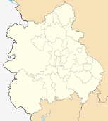 | |
| Shropshire |
| |
| Staffordshire |
| |
| Warwickshire |
| |
| West Midlands |
| |
| Worcestershire |
| |