Worcester
Worcester (/ˈwʊstər/ (![]()
City of Worcester | |
|---|---|
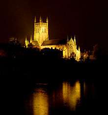
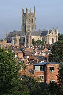 Worcester Cathedral from Fort Royal Hill | |
 Coat of arms | |
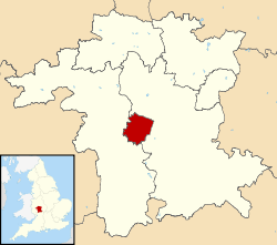 City of Worcester shown within Worcestershire | |
| Coordinates: 52.192°N 2.220°W | |
| Sovereign state | United Kingdom |
| Constituent country | England |
| Region | West Midlands |
| Non-metropolitan county | Worcestershire |
| Status | Non-metropolitan district, City |
| Admin HQ | Worcester |
| Government | |
| • Type | Non-metropolitan district council |
| • Borough council | Worcester City Council (Shared) |
| • MPs | Robin Walker (Conservative) |
| Area | |
| • Total | 12.85 sq mi (33.28 km2) |
| Area rank | 296th (of 317) |
| Population (mid-2015) | |
| • Total | 101,328 |
| • Rank | 235th (of 317) |
| • Density | 7,900/sq mi (3,000/km2) |
| Time zone | UTC0 (GMT) |
| • Summer (DST) | UTC+1 (BST) |
| Postcodes | WR1-5 |
| Area code(s) | 01905 |
| ONS code | 47UE (ONS) E07000237 (GSS) |
| OS grid reference | SO849548 |
| Website | www |
History
Early history
The trade route past Worcester, later forming part of the Roman Ryknild Street, dates from Neolithic times. It commanded a ford over the River Severn, which was tidal below Worcester before public works in the 1840s, and was fortified by the Britons about 400 BC. It would have been on the northern border of the Dobunni and probably subject to the larger communities of the Malvern hill forts.[2]
The Roman settlement at the site is omitted from Ptolemy's Geography, the Antonine Itinerary and the Register of Dignitaries, but would have grown up as the road opened between Glevum (Gloucester) and Viroconium (Wroxeter) in the 40s and 50sAD. The Severn crossing at Worcester was also the likely destination of the unfinished east-west Roman-dated road from Magnis (west of Hereford), until it disappeared from the historical record east of Stretton Grandison.
Worcester may have been the "Vertis" of the 7th-century Ravenna Cosmography. Charcoal from the Forest of Dean enabled Romans to operate pottery kilns and ironworks.[3] They may have built a small fort.[4] There is no sign of municipal buildings to indicate an administrative role.[5]
In the 3rd century AD, Roman Worcester occupied a larger area than the subsequent medieval city, but silting of the Diglis Basin caused the abandonment of Sidbury. Industrial production ceased and the settlement contracted to a defended position along the lines of the old British fort at the river terrace's southern end.[6]
This settlement is generally identified with the Cair Guiragon,[7] listed among the 28 cities of Britain in the History of the Britons, attributed to Nennius.[8][9] This is probably not a Common Brittonic, name, but an adaption of the Old English Weorgoran ceaster or fort of the Weorgoran.[lower-alpha 1]
Anglo-Saxon town
The form of the place name varied over history, with Early English and subsequent Norman French additions. At its settlement in 7th century by the Angles of Mercia it was Weogorna. After centuries of warfare against the Vikings and Danelaw it had become a centre for the Anglo-Saxon army or here known as Weogorna ceastre (Worcester Camp). Between the 10th and 12th centuries, when scholasticism flourished, it became Wirccester. The county later developed from the Wigornia shire of the Anglo-Norman period, with foundations of market fairs by the Henrician and Edwardian parliaments (1216–1377). It was still known as County Wigorn in 1750, with its Shire Courts divided into hundreds.
The Weorgoran were probably a sub-tribe of the larger kingdom of the Hwicce, which occupied present-day Worcestershire, Gloucestershire and western Wiltshire. They would have entered the area some time after the 577 Battle of Dyrham.[10]In 680, Worcester was chosen as their fort over the larger Gloucester, and the royal court at Winchcombe as the episcopal see of a new bishopric, suggesting there was already an established and powerful Christian community when the site fell into English hands. The oldest known church was St Helen's, which was certainly of British origin. The later Saxon cathedral was dedicated to St Peter.[6]
Worcester appears often in pre-Viking historic records. Frequent references to the church and monastic communities give evidence of extensive land ownership by the Church. The earls of Mercia in King Alfred's reign fortified it "for protection of all the people", at the request of Bishop Werfrith. Its defences were to be maintained at the expense of the townspeople. A document detailing this and privileges granted to the Church notes the existence of Worcester market and borough court, differentiates between church and market quarters in the city, and specifies the role of the King in relation to the roads.[11]
Worcester's fortifications are likely to have followed the line of the wall, extant until the 1600s, except possibly in the south-east area near the early castle. It is referred to at the time as a wall and so may have been of stone.[11]
Worcester became a centre of monastic learning and church power. Oswald of Worcester, appointed Bishop in 961, was an important reformer alongside the Archbishop of York. The last Anglo-Saxon Bishop of Worcester, St Wulfstan or Wulstan, was a reformer, who remained in office until he died in 1095.
Worcester became a focus of tax resistance against the Danish Harthacanute. Two huscarls were killed in May 1041 while seeking to collect taxes for the expanded navy, and been driven into the Priory. A military force composed of the country's powerful earls and their thegns was sent to deal with the non-payment. It included Siward, Earl of Northumbria, Earl Godwine of Wessex and Leofric Earl of Mercia, who was himself ruler of the Hwicce and from a family of traditional ealdormen of that tribal hidage.[10] The townspeople tried to defend themselves by occupying the Severn island of Bevere, two miles up river. After Harthacnut's men had sacked the city and set it alight, agreement was reached and the populace returned to rebuild its city.[11]
Worcester possessed a mint in the late Anglo-Saxon period, with seven moneyers in the reign of Edward the Confessor. This implies a middling role in trade for the city.[11]
Medieval
Early medieval
Worcester was counted for tax purposes within the neighbouring rural hundreds at the start of the Norman period, but was administratively independent.[11] Its growth and position as a market town for goods and produce rested on its river crossing and bridge and its position on the road network. The nearest bridges over the Severn were at Gloucester and Bridgnorth in the 14th century. The main road from London to mid-Wales ran through Worcester, then north-west to Kidderminster, Bridgnorth and Shrewsbury, and via Bromsgrove to Coventry and on to Derby. Southward it connected with Tewkesbury and Gloucester.[11]
There had been a bridge in Worcester since at least the 11th century. It was replaced in the early 14th century by one situated below the current Newport Street. It had six arches on piers with starlings, the middle pier having a gatehouse.[11]
The upkeep of the city walls was paid for by the residents. Its somewhat irregular course included bastions and a watercourse. The entrances to the city were through defensive gates built at various times, including St Martin's in the east, Sidbury to the south, Friar Gate, Edgar Tower, and Water Gate. There were six gates by the 16th century.[11]

Worcester was also a centre of religious life. The several monasteries up to the dissolution included Greyfriars, Blackfriars, the Penitent Sisters, and the Benedictine Priory, now Worcester Cathedral.[12] Monastic houses provided hospital and educational services, including Worcester School. St Wulstan's Hospital was founded about 1085, but dissolved with the monasteries in 1540. St Oswald's Hospital may have been founded by St Oswald. Much land and property in Worcester were held by the church.[11]
Domesday Book (1086) also records many town houses belonging to rural landowners, presumably used as residences while selling produce from their lands.[11] In the 1100s, Worcester suffered a number of city fires. The first, on 19 June 1113, destroyed town, castle and cathedral. A second ensued in November 1131.[11]
The 12th-century town (then better defended) was attacked in 1139, 1150 and 1151 during the civil war between King Stephen and Empress Matilda, daughter of Henry I. The 1139 attack again resulted in a fire that destroyed part of the city, with citizens being held for ransom. Another fire in 1189 destroyed much of the city for the fourth time that century.[11]
Worcester received its first royal charter in 1189. This set the annual payment made to the Crown at £24 a year and stipulated that the city would deal directly with the Crown Exchequer, not through the county sheriff, who would no longer have jurisdiction over the city. However, Worcester's charter was not renewed under King John, who could levy increased arbitrary taxation or tallage, demanding £100 in 1214.
In 1227 under King Henry III, Worcester regained its charter and was granted more freedoms. The annual tax was raised to £30. The county sheriff was again removed from his role of representing the city to the Crown, except in limited circumstances. A guild of merchants was created, with a trading monopoly for those admitted. Villeins who resided in the city for a year and day became members of the guild and were to be deemed free. The charter was renewed in 1264.[11] Worcester's institutions grew more slowly than those of most county towns and had detectably archaic sides to them, probably due to the power of the local aristocracy.[11]
Jewish persecution and expulsions
Worcester had a small Jewish population by the late 12th century. It was one of a number of places allowed to keep records of debts, in an official locked chest known as an archa.[13] Jewish life probably centred around what is now Copenhagen Street.
The Diocese was hostile to the Jewish community. Peter of Blois was commissioned by a Bishop of Worcester, probably John of Coutances, to write an anti-Judaic treatise, Against the Perfidy of Jews, around 1190.[14]
William de Blois as Bishop of Worcester imposed strict rules on Jews within the diocese in 1219.[15] As elsewhere in England, Jews were compelled to wear square white badges, supposedly representing tabulae.[16] In most places, this requirement was waived as long as fines were paid. While enforcing the church edicts on wearing badges, Blois tried to impose additional restrictions on usury. He wrote to Pope Gregory IX in 1229 to request better powers of enforcement and further, harsher measures, which were granted.[17]
A national assembly of Jewish notables was summoned to Worcester by the Crown in 1240 to assess their wealth for taxation. There Henry III "squeezed the largest tallage of the thirteenth century from his Jewish subjects."[18]
In 1263 Worcester's Jewish residents were attacked by a baronial force under Robert Earl Ferrers and Henry de Montfort. Most were killed.[11] Ferrers used this chance to remove titles to his debts by seizing the archae.[19] The Worcester massacre was part of a wider campaign by allies of Simon de Montfort at the start of the Second Barons' War. A massacre of London Jewry also occurred. In 1275, Jews still in Worcester were expelled to Hereford,[11] under anti-Jewish terms for towns under the jurisdiction of the Queen Mother.[20]
Late medieval
Worcester's Ordinances of the sixth year of Edward IV, renewed in 1496–1497 in 82 clauses, give a detailed picture of city life and organisation in the late medieval period, as enforced by its bailiffs. Chamberlains received and accounted for rents and other income, and the use of common lands in Worcester was laid down. Trade regulations covered bread and ale. Others dealt with sanitation, fire regulations and upkeep of the city wall, quays and pavements. Public order and crimes, including affray, are covered. Citizens were given the privilege of being imprisoned underneath the Guildhall rather than in the town jail, except for the most serious offences.[11]
The cloth industry was also regulated by the Ordinances. Apart from setting weights and measures, they sought to protect artisans engaged in the trade. Payment in kind was banned, with fines of 20 shillings for those paying otherwise than in gold and silver. Employees had to be living in the city and its suburbs.[11]
Worcester elected members of Parliament at the Guildhall, by the loudest shout rather than raising of hands. Members of Parliament had to own freehold property worth 40 shillings a year and be "of good name and fame, not outlawed, not acombred in accyons as nygh as men may knowe, for worshipp of the seid cite".[21] Their wages were levied by the Constable.
The city council was organised by a system of co-option, with 24 members of the high chamber and 48 of the lower. Committees appointed two bailiffs and made financial decisions; the two chambers agreed the city's rules or ordinances.[11]
By late medieval times the population had reached 1,025 families, excluding the cathedral quarter, so that it probably stood under 10,000.[22] Worcester's suburbs extended beyond the limits of its walls[11]
Manufacture of cloth and allied trades began locally. Leland stated in the mid 1500s, for instance, that "the welthe of the towne of Worcestar standithe most by draping, and noe towne of England, at this present tyme, maketh so many cloathes yearly as this towne doth."[23] The glove-making trade also had its roots in this period.[11]
Craft guilds
Medieval and early modern Worcester developed a system of craft gilds to regulate who could work in a trade, lay down trade practices and training, and provide social support for members. The city's late medieval ordinances banned tilers from forming a guild and encouraged tilers to settle in Worcester to trade freely. Roofs of thatch and wooden chimneys were banned in order to reduce risks of fire.[11]
Early modern period
The Dissolution saw the Priory's status change, as it lost its Benedictine monks. There were around 36 monks and a Prior at the dissolution in 1540. Some 16 were given pensions immediately or soon after, the rest being employed in the new Deanery. It was necessary to set up "public" schools to replace monastic education in Worcester, as elsewhere. This led to the establishment of King's School. Worcester School continued to teach. St Oswald's Hospital survived the dissolution, later providing almshouses;[24] the charity and its housing survives to the present day.
The city gained the right to elect a Mayor, and was designated a county corporate in 1621, giving it autonomy from local government. From this point, Worcester was governed by a mayor, recorder and six aldermen. Councillors were selected by co-option.[11]
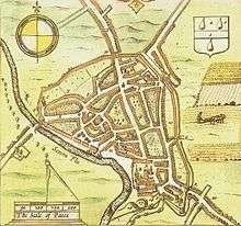
Worcester contained green spaces such as orchards and fields between its main streets, within the city wall, as appears on Speed's map of 1610. The walls were still more or less complete at the time, but suburbs had been established beyond them.
Civil war
Worcester equivocated, but eventually sided with Parliament before the outbreak of civil war in 1642. It was swiftly occupied by the Royalists, who billeted troops in the city and used the Cathedral to store munitions. Essex briefly retook the city for Parliament after the Battle of Powick Bridge, the first engagement of the war. Parliamentary troops then ransacked the Cathedral. Stained glass was smashed and the organ destroyed, along with library books and monuments.[25]
Essex was soon forced to withdraw after the Battle of Edgehill, and the city spent the rest of the war under Royalist occupation, as did most of the county. Worcester was a garrison town and had to bear the expense of sustaining and billeting a large number of Royalist troops. During the Royalist occupation, the suburbs were destroyed to make defence easier. Responsibility for maintenance of defences was transferred to the military command. High taxation was imposed, and many male residents impressed into the army.[26]
As Royalist power collapsed in May 1646, Worcester was placed under siege. Worcester had some 5,000 civilians and a Royalist garrison of about 1,500 men facing a New Model Army force of 2,500–5,000. The city surrendered on 23 July, bringing the first civil war to a close in Worcestershire.[27]
In 1651 a Scottish army, 16,000 strong, marched south along the west coast in support of Charles II's attempt to regain the Crown. As the army approached, Worcester Council voted to surrender, fearing further violence and destruction. The Parliamentary garrison withdrew to Evesham in the face of the overwhelming numbers against them. The Scots were billeted in and around the city, again at great expense and causing further anxiety among residents. The Scots were joined by very limited local forces, including a company of 60 men under Francis Talbot.[28]
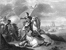
The Battle of Worcester took place on 3 September 1651 in fields to the west and south of the city, near the village of Powick. Charles II was easily defeated by Cromwell's forces of 30,000 men. Charles II returned to his headquarters in what is now known as King Charles House in the Cornmarket, before fleeing in disguise with Talbot's help to Boscobel House in Shropshire, from where he eventually escaped to France. Worcester was then heavily looted by the Parliamentarian army. The city council estimated £80,000 of damage was done and the subsequent debts were still not recovered in the 1670s.[29]
From 1646 to 1660, the Bishopric was abolished and the Cathedral fell into disrepair.
After the Restoration
After the Restoration in 1660, Worcester cleverly used its location as the site of the final battles of the First Civil War (1646) and Third Civil War (1651) to mount an appeal for compensation from Charles II. Though unbased on historical fact, it invented the epithet Fidelis Civitas (The Faithful City), since included in the city's coat of arms.[30][31]

The Guildhall rebuilt in 1721 to replace an earlier one on the site is a Grade I listed Queen Anne-style building described by Pevsner as a town hall "as splendid as any of C18 England".[32]
Worcester's historic bridge was replaced on 17 September 1781 at a cost of £29,843 including its approaches. As the city population expanded, the green areas between the main streets filled with housing and back streets, so that the extent of the city and suburbs remained much the same as in the early 1600s. Large stretches of the city walls had been removed by 1796.[11] Meanwhile the Royal Worcester Porcelain Company factory was founded by Dr John Wall in 1751. Production continued until 2009. A handful of decorators are still employed at the factory, and the museum on the site remains open. Since 2015 there has been re-development there devoted to housing.
Industrial revolution and Victorian era

Worcester in the late 18th and early 19th centuries was a major centre for glove making, employing nearly half the glovers in England at its peak (over 30,000 people).[33] In 1815 the Worcester and Birmingham Canal opened, allowing Worcester goods to be transported more easily.
Riots took place in 1831, in response to the defeat of the Reform Bill, reflecting discontent with the city administration and the wider lack of democratic representation.[11] Riots occurred elsewhere, including Bristol. Local government reform took place in 1835, which for the first time created election procedures for councillors, but also restricted the ability of the city to buy and sell property, requiring Treasury permission.[11]
Up until 1835, the legal distinction between a select group of citizens with specific privileges and other residents of the town had survived.[11]
The British Medical Association (BMA) was founded in the Board Room of the old Worcester Royal Infirmary building in Castle Street in 1832.[34] While part of the Royal Infirmary has now been demolished to make way for the University of Worcester's new city campus, the original Georgian building has been preserved.[35] One of the old wards opened as a medical museum, the Infirmary, in 2012.[36][37]
Railways opened in Worcester in 1850, with Shrub Hill, jointly owned by the Oxford, Worcester and Wolverhampton Railway and Midland Railway, initially running to Birmingham only. Foregate Street was opened in 1860 by the Hereford and Worcester Railway, quickly incorporated into the West Midland Railway. The WMR lines became part of the Great Western Railway after 1 August 1863. The railways also gave Worcester thousands of jobs with the just under half of all GWR passenger coaches built in Worcester and the three signalling factories including the largest railway signalling company in the World: McKenzie & Holland.
In 1882 Worcester hosted the Worcestershire Exhibition, inspired by the Great Exhibition in London. There were sections for exhibits of fine arts (over 600 paintings), historical manuscripts and industrial items. The profit was £1,867.9s.6d. The number of visitors is recorded as 222,807. Some of the profit from the exhibition was used to build the Victoria Institute in Foregate Street, Worcester. This was opened on 1 October 1896 and originally housed the city art gallery and museum; now located on Foregate Street.
Twentieth century to present
Rail reorganisation in 1922 saw the Midland Railway's routes from Shrub Hill absorbed into the London, Midland and Scottish Railway.
During the Second World War, the city was chosen to be the seat of an evacuated government in case of mass German invasion. The War Cabinet, along with Winston Churchill and some 16,000 state workers, would have moved to Hindlip Hall (now part of the complex forming the Headquarters of West Mercia Police), 3 miles (4.8 km) north of Worcester and Parliament would have temporarily seated in Stratford-upon-Avon. The former RAF station RAF Worcester was located east of Northwick.
A fuel storage depot was constructed in 1941/2 by Shell Mex & BP (later operated by Texaco) for the government on the eastern bank of the River Severn, about one mile south of Worcester. There were six 4,000 ton semi-buried tanks for the storage of white oils. It had no rail or road loading facilities but distribution could be carried out by barge through the Diglis basin and the depot could receive fuel either by barge or the GPSS pipeline network. It was at one time used as a civil reserve storing gas oil and then stored aviation kerosene for USAFE. In the early 1990s it was closed down and was sold for housing in the 2000s.[38]
In the 1950s and 1960s large areas of the medieval centre of Worcester were demolished and rebuilt as a result of decisions by town planners. This was condemned by many such as Nikolaus Pevsner who described it as a "totally incomprehensible... act of self-mutilation".[39] There is still a significant area of medieval Worcester remaining, examples of which can be seen along City Walls Road, Friar Street and New Street, but it is a small fraction of what was present before the redevelopments.
The current city boundaries date from 1974, when the Local Government Act 1972 transferred the parishes of Warndon and St. Peter the Great County into the city.
Images
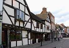 Tudor buildings in Friar Street |
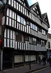 Tudor building with jettied upper storey in New Street |
 Worcester Shrub Hill railway station with a London Midland train |
Governance
The Conservatives had a majority on the council from 2003 to 2007, when they lost a by-election to Labour meaning the council had no overall control.[40] The Conservatives remained with the most seats overall with 17 out of 35 seats after the 2008 election.[41]
The council currently has no overall control, but is under the leadership of Cllr Marc Bayliss (Conservative) and deputy leader Cllr Adrian Gregson (Labour). Local political parties represented on the council are the Conservatives, Labour, Green Party and Liberal Democrats.[42][43][44][45]
Worcester has one member of Parliament, Robin Walker of the Conservative Party, who represents the Worcester constituency as of the May 2010 general election.[46]
The County of Worcestershire's local government arrangement is formed of a non-metropolitan county council (Worcestershire County Council) and six non-metropolitan district councils, with Worcester City Council being the district council for most of Worcester, with a small area of the St Peters suburb actually falling within the neighbouring Wychavon District council. The Worcester City Council area includes two parish councils, for Warndon Parish Council and St Peter the Great.
Worcester Guildhall houses the local council and dates from 1721 (see History).
Geography
Notable suburbs in Worcester include Barbourne, Blackpole, Cherry Orchard, Claines, Diglis, Dines Green, Henwick, Northwick, Red Hill, Ronkswood, St Peter the Great (also simply known as St Peter's), Tolladine, Warndon and Warndon Villages (which was once the largest housing development in the country when the area was being constructed in the late 1980s/very early 1990s). Most of Worcester is on the eastern side of the River Severn; Henwick, Lower Wick, St John's and Dines Green are on the western side.
Climate
Worcester enjoys a temperate climate with warm summers and mild winters generally. However, the city can experience more extreme weather and flooding is often a problem.[47] In 1670, the River Severn burst its banks and the subsequent flood was the worst ever seen by Worcester. The closest flood height to what is known as the Flood of 1670 was when the Severn flooded in the torrential rains of July 2007, which is recorded in the Diglis Basin.[48] And then again in 2014.[49]
During the winters of 2009–2010 and 2010–2011, the city underwent long periods of sub-freezing temperatures and heavy snowfalls. In December 2010 the temperature dropped to −19.5 °C (−3.1 °F) in nearby Pershore.[50] The River Severn and the River Teme partially froze over in Worcester during this cold period. By contrast, Worcester recorded a temperature 36.6 °C (97.9 °F) on 2 August 1990.[51] Between 1990 and 2003, weather data for the area was collected at Barbourne, Worcester. After the closure of this weather station, the nearest one is located at Pershore.[52]
| Climate data for Worcester | |||||||||||||
|---|---|---|---|---|---|---|---|---|---|---|---|---|---|
| Month | Jan | Feb | Mar | Apr | May | Jun | Jul | Aug | Sep | Oct | Nov | Dec | Year |
| Record high °C (°F) | 17.1 (62.8) |
19.6 (67.3) |
21.1 (70.0) |
26.6 (79.9) |
28.2 (82.8) |
33.1 (91.6) |
33.8 (92.8) |
36.6 (97.9) |
28.8 (83.8) |
28.4 (83.1) |
18.6 (65.5) |
17.6 (63.7) |
36.6 (97.9) |
| Average high °C (°F) | 7 (45) |
8 (46) |
11 (52) |
14 (57) |
17 (63) |
20 (68) |
22 (72) |
22 (72) |
19 (66) |
15 (59) |
10 (50) |
8 (46) |
14 (58) |
| Average low °C (°F) | 2 (36) |
1 (34) |
3 (37) |
4 (39) |
7 (45) |
10 (50) |
12 (54) |
12 (54) |
10 (50) |
7 (45) |
4 (39) |
2 (36) |
6 (43) |
| Record low °C (°F) | −14.1 (6.6) |
−12.7 (9.1) |
−9.4 (15.1) |
−7.3 (18.9) |
−2.3 (27.9) |
−1.0 (30.2) |
2.7 (36.9) |
3.6 (38.5) |
−0.6 (30.9) |
−5.1 (22.8) |
−10.5 (13.1) |
−19.5 (−3.1) |
−19.5 (−3.1) |
| Average rainfall mm (inches) | 53 (2.1) |
31 (1.2) |
31 (1.2) |
42 (1.7) |
47 (1.9) |
48 (1.9) |
50 (2.0) |
53 (2.1) |
48 (1.9) |
56 (2.2) |
54 (2.1) |
50 (2.0) |
563 (22.3) |
| Source #1: [53] | |||||||||||||
| Source #2: Barbourne and Pershore extremes (nearest stations)[52] | |||||||||||||
Green belt
Worcester is within a green belt region that extends into the wider surrounding counties, and is in place to reduce urban sprawl between the cities and towns in the nearby West Midlands conurbations centred around Birmingham and Coventry, discouraging further convergence, protect the identity of outlying communities, encourage brownfield reuse, and preserve nearby countryside. This is achieved by restricting inappropriate development within the designated areas, and imposing stricter conditions on permitted building.[54]
Within the city boundary, there is a small extent of green belt north of the Worcester & Birmingham canal, and north of the Perdiswell and Northwick suburbs. This is part of a larger, isolated tract south of the main green belt that extends into the adjacent Wychavon district, minimising urban sprawl between Fernhill Heath and Droitwich Spa, and maintaining their separation. The green belt was first drawn up under Worcestershire County Council in 1975, and the size within the borough in 2017 amounted to some 240 hectares (2.4 km2; 0.93 sq mi).[55]
Demography and religion
The 2011 census recorded Worcester's population at 98,768. About 93.4 per cent of Worcester's population was white; of which 89.1 percentage points were White British – greater than the national average.[56] The largest religious group are Christians, who make up 63.7 per cent of the city's population.[56] People who report having no religion or decline to state their religion make up 32.3 per cent of the city's population. The next largest religious group, Muslims, make up 2.9 per cent. Ethnic minorities include people of Pakistani, Bangladeshi, Chinese, Indian, Italian and Polish origin, with the largest single minority group being British Pakistanis, numbering around 1,900: 1.95 per cent of Worcester's population. This has led to Worcester containing a small but diverse range of religious groups; as well as the commanding Anglican Worcester Cathedral, there are also Catholic, United Reformed Church[57] and Baptist churches, a large centre for the Church of Jesus Christ of Latter-day Saints, Islamic mosques and a number of smaller groups for oriental religions such as Buddhism and the International Society for Krishna Consciousness.
Worcester is the seat of a Church of England bishop, whose official signature is the personal Christian name followed by Wigorn. (an abbreviation for the Latin Wigorniensis, meaning 'of Worcester').[58] This is also used occasionally to abbreviate the name of the county. The Archdeacon of Worcester, inducted in November 2014, was Rector of St Barnabas with Christ Church in Worcester for eight years.
Economy
The city of Worcester, located on the River Severn and with transport links to Birmingham and other parts of the Midlands through the vast canal network, became a centre for many light industries. The late Victorian period saw the growth of ironfounders like Heenan & Froude, Hardy & Padmore and McKenzie & Holland.
Glove industry
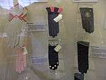
One of the flourishing industries was glove making, which peaked between 1790 and 1820, when about 30,000 were employed by 150 firms. At this time nearly half the glove manufacturers of Britain were located in Worcestershire.
In the 19th century, the industry declined as import taxes on foreign competitors, mainly French, were greatly reduced. By the mid-20th century, only a few Worcester glove companies survived since gloves became less fashionable and free trade enabled cheaper imports from the Far East. Nevertheless, at least three glove manufacturers survived until the late 20th century: Dent Allcroft, Fownes and Milore. Queen Elizabeth II's coronation gloves were designed by Emil Rich and manufactured in the Worcester Milore factory.[59][60]
Manufacturing
The inter-war years saw rapid growth in engineering and machine-tool manufacturing firms such as James Archdale and H. W. Ward, castings for the motor industry from Worcester Windshields and Casements, valve design and manufacture from Alley & MacLellan, Sentinel Valve Works, mining machinery from Mining Engineering Company (MECO) – later part of Joy Mining Machinery, and open-top cans from Williamsons, although G. H. Williamson and Sons had become part of the Metal Box Co in 1930. Later the company became Carnaud Metal Box PLC.
Worcester Porcelain operated in Worcester until 2009, when the factory closed down due to the recession. However, the site still houses the Museum of Royal Worcester, which is open daily to visitors.[61]
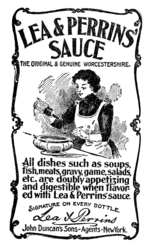
One of Worcester's most famous products, Lea & Perrins Worcestershire sauce, is made and bottled at the Midland Road factory in Worcester, which has been its home since 16 October 1897. Messrs Lea and Perrins originally came together in a chemist's shop on the site of the Debenhams's store in Crowngate Shopping Centre.
Worcester has what is claimed to be the oldest newspaper in the world still in publication: Berrow's Worcester Journal. It traces its descent from a news-sheet started in 1690.
The surprising foundry heritage of the city is represented by Morganite Crucible at Norton which produces graphitic shaped products and cements for use in the modern industry.[62] The city is home to the European manufacturing plant of Yamazaki Mazak Corporation, a global Japanese machine tool builder established here in 1980.[63]
Worcester Heating systems was started in the city in 1962 by Cecil Duckworth. The company was bought by Bosch and renamed Worcester Bosch in 1996.[64][65]
Retail trade
The Kays mail-order business was founded in Worcester in the 1880s and operated from numerous premises in the city until 2007. It was then bought out by Reality, owner of the Grattan catalogue. Kays' former warehouse building was demolished in 2008 and replaced by housing.[66]
The city is additionally a major retail centre, with several covered shopping centres to accommodate the major chains and a host of independent shops and restaurants, particularly in Friar Street and New Street.
Worcester's main shopping centre is the High Street, with several major retail chains. The High Street was partly modernised in 2005 amid controversy and further modernised in 2015, with current redevelopment of Cathedral Plaza and Lychgate Shopping Centre. Much of the protest came at the felling old trees, the duration of the works (caused by weather and an archaeological find) and the removal of flagstones outside the city's 18th-century Guildhall.[67]
The other main thoroughfares are the Shambles and Broad Street, while the Cross (and its immediate surrounding area) is the city's financial centre for the majority of Worcester's main bank branches.
There are three main covered shopping centres in the city centre: CrownGate Shopping Centre, Cathedral Plaza and Reindeer Court. There is also an unenclosed shopping area immediately east of the city centre called St Martin's Quarter. There are three retail parks, the Elgar and Blackpole retail parks located in the inner suburb of Blackpole, and the Shrub Hill Retail Park in neighbouring St. Martin's Quarter. Retailers such as ASDA, B & M and Aldi are all located close to St Martin's Quarter.
Landmarks
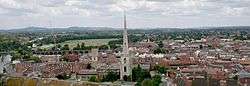
The most famous landmark in Worcester is the Anglican Worcester Cathedral. The current building, officially the Cathedral Church of Christ and the Blessed Virgin Mary, was known as Worcester Priory before the English Reformation. Construction begun in 1084. Its crypt dates from the 10th century. It includes the only circular chapter house in the country. The cathedral houses the tomb of King John.
Near the cathedral is the spire of St Andrew's Church, known as Glover's Needle. The rest of the church was demolished in 1949.[68]
The parish church of St Helen, on the north side of the High Street, is mainly medieval, with a west tower rebuilt in 1813. The east end, re-fenestration and porch were completed by Frederick Preedy in 1857–1863. There was further restoration, by Aston Webb, in 1879–1880. It is a Grade II*listed building.[69]
The high-water marks from the flood of 1670 and more recent flood levels appear on a brass plate on a wall adjacent to the path along the river that leads to the Cathedral.
Limited parts of Worcester's city wall remain.
The Hive, on the north side of the River Severn at the former cattle market site, is Worcester's joint public and university library and archive centre, heralded as "the first of its kind in Europe", and a prominent feature on the skyline. With seven towers and a golden rooftop, it has gained recognition, winning two international awards for building design and sustainability.[70][71]
The city's three main public open spaces Cripplegate Park, Gheluvelt Park and Fort Royal Park, the last being on the site of an English Civil War battle. In addition, there is an open area known as Pitchcroft to the north of the city centre on the east bank of the River Severn, which is a public space except on days when it is used for horse racing. Gheluvelt Park commemorates the part played by Worcestershire Regiment's 2nd Battalion in the Battle of Gheluvelt in the First World War.[72]
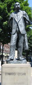
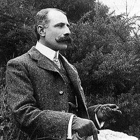
A statue of Sir Edward Elgar, commissioned from Kenneth Potts and unveiled in 1981, stands at the end of Worcester High Street facing the Cathedral, yards from the original location of his father's music shop, which was demolished in the 1960s.[73] Elgar's birthplace was the nearby village of Broadheath.
There are also two large wooded areas in the city, Perry Wood and Nunnery Wood, covering 12 and 21 hectares respectively. Perry Wood is often said to be where Oliver Cromwell met and made a pact with the Devil.[74] Nunnery Wood is integral to the adjacent Worcester Woods Country Park, itself next door to County Hall on the east side of the city.
Transport
Road
The M5 Motorway runs north-south immediately to the east of the city and is accessed by Junction 6 (Worcester North) and Junction 7 (Worcester South). It connects Worcester to most parts of the country, including London, which is only 118 miles (190 km) using the A44 via the Cotswolds and M40. A faster journey to London is possible via the M5, M42 and M40 for an increased distance of 134 miles (216 km).
The main roads through the city include the A449 roadA449 south-west to Malvern and north to Kidderminster. The A44 runs south-east to Evesham and west to Leominster and Aberystwyth and crosses Worcester Bridge. The A38 trunk road runs south to Tewkesbury and Gloucester and north-north-east to Droitwich and Bromsgrove and Birmingham. The A4103 goes west-south-west to Hereford. The A422 heads east to Alcester, branching from the A44 a mile east of the M5. The city is partially ringed by A4440.
Carrington Bridge on the A4440 is the second road bridge across the Severn, linking the A38 from Worcester towards Gloucester with the A449 to Malvern. It is one of Worcestershire's busiest roads. The single-carriageway bridge is due to be doubled by 2021, making the Southern Link Road dual between Junction 7 of the M5 and Powick Roundabout.[75]
Rail
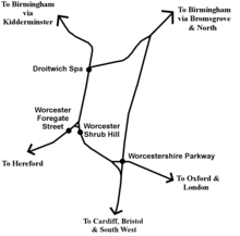
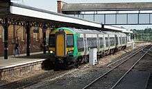
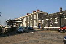
Worcester has three stations, Worcester Foregate Street and Worcester Shrub Hill in the city centre. A third station on the edge of the city, Worcestershire Parkway opened in 2020.
The Cotswold line towards Great Malvern and Hereford crosses Foregate St on an arched cast-iron bridge remodelled by the Great Western Railway in 1908 with a decorative cast-iron exterior serving no structural purpose.[76] Between Foregate St and the St John's area of the city, heading towards Malvern and Hereford, the line crosses the Worcester viaduct over the River Severn.
Worcester Shrub Hill lies about one mile east of the city centre on Shrub Hill Road. The station is on part of today's Cross Country Route looping off the Birmingham to Gloucester railway.
Alongside Worcester Shrub Hill station in Shrub Hill Road was the Worcester Engine Works. The polychrome brick building was erected about 1864 and probably designed by Thomas Dickson. It was not a success: only 84 locomotives were built and the works closed in 1871.[77] The chairman was Alexander Clunes Sheriff.
Both stations have frequent trains to Birmingham via Droitwich Spa, either through Kidderminster and Stourbridge into Birmingham Snow Hill and Birmingham Moor Street then onwards usually to Dorridge or Whitlocks End, or via Bromsgrove and University and Birmingham New Street. These services are run by West Midlands Trains. From both stations, trains run to Pershore, Evesham and onto the Cotswolds, Oxford and London.[78]
Buses
The main operator in and around the city is First Midland Red. A few smaller operators provide services in Worcester, including Astons, DRM and LMS Travel. The terminus and interchange for many bus services is Crowngate Bus Station in the city centre.
The city had two park and ride sites – off the A38 in Perdiswell (from 2001) and at Sixways Stadium next to the M5 (from 2009). Worcestershire County Council voted to close both in 2014 as part of a package of cutbacks.[79] The service at Sixways Stadium has since been reinstated, with LMS Travel operating the W3 route to Worcestershire Royal Hospital, but avoiding city centre bus station.[80]
Air
Worcester's nearest major airport is Birmingham Airport, which is accessible by road and rail. Gloucestershire Airport is about 25 miles away and provides General Aviation connections and scheduled services with Citywing to Jersey, the Isle of Man and Belfast.
Education
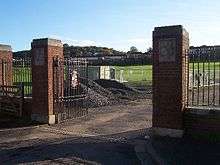
.jpg)
The University of Worcester was awarded university status in 2005 by the Privy Council, having been known since 1997 as University College Worcester (UCW) and before that as Worcester College of Higher Education. From 2005 to 2010 it was the fastest growing university in the UK, more than doubling its student population. The university has an independent Worcester Students Union institution. The city is also home to two colleges, Worcester Sixth Form College and Heart of Worcestershire College.
High schools
The high schools located in the city are Bishop Perowne CofE College, Blessed Edward Oldcorne Catholic College, Christopher Whitehead Language College, Tudor Grange Academy Worcester, Nunnery Wood High School and New College Worcester. The last caters for blind and partially sighted pupils aged 11–18.
Independent schools
Worcester is also the seat of three independent schools. The Royal Grammar School, founded in 1291 and Alice Ottley School merged in 2007. The King's School was re-founded in 1541 under King Henry VIII. St Mary's School, a girls' Catholic school, was the only remaining single-sex independent school, but closed in July 2014. Other independent schools include the Independent Christian School, the River School in Fernhill Heath and New College Worcester.
Sport
- Worcester Warriors, an Aviva Premiership Rugby Union team which plays at Sixways Stadium
- Worcestershire County Cricket Club whose home ground is New Road
- Worcester City Football Club
- Worcester Hockey Club has teams entered in the West Hockey Leagues.[83]
- Worcester St Johns Cycling Club
- Worcester Wolves, a professional basketball team in the British Basketball League, plays at the Worcester Arena
- Worcester Racecourse is on an open area known as "Pitchcroft" on the east bank of the River Severn.
Culture
Festivals and shows
Every three years Worcester becomes home to the Three Choirs Festival, which dates from the 18th century and is credited with being the oldest music festival in the British Isles. The location rotates each year between the cathedral cities of Gloucester, Hereford and Worcester. Famous for championing of English music, especially that of Elgar, Vaughan Williams and Gustav Holst, Worcester was hosted the festival in July 2014.[84]
The Worcester Festival established in 2003 by Chris Jaeger MBE is held in August and consists of music, theatre, cinema and workshop events, as well as an established Beer Festival.[85] Worcester Festival ends with a free firework display on the banks of the River Severn on the Monday of the August bank holiday. The Artistic Director is now actor, director and writer, Ben Humphrey.
For one weekend a year the city plays host to the Worcester Music Festival. It comprises a weekend of original music performed by predominantly local bands and musicians. All performances are free and take place around the city centre in bars, clubs, community buildings, churches and the central library.
Founded in 2012, the Worcester Film Festival, is all about placing Worcestershire on the film-making map and encouraging local people to get involved in making film. The first festival took place at the Hive and including screenings, workshops and talks.[86]
The Victorian-themed Christmas Fayre] is a major source of tourism in late November/early December with over 200 stalls lining the streets, and over 100,000 visitors.[87]
The CAMRA Worcester Beer, Cider and Perry Festival takes place for three days each August on Pitchcroft Race Course.[88] It is the largest beer festival in the West Midlands and in the UK top ten with attendances of around 14,000.[89]
Arts and cinema
The famous 18th-century actress Sarah Siddons made her acting début at the Theatre Royal in Angel Street. Her sister, the novelist Ann Julia Kemble Hatton, otherwise known as Ann of Swansea, was born in the city.[90] Matilda Alice Powles, better known as Vesta Tilley, a leading male impersonator and music hall artiste was also born in Worcester.[91]
In present-day Worcester, the Swan Theatre[92] stages professional touring and local amateur productions and is the base for the Worcester Repertory Company. Past Artistic Directors have included John Doyle and David Wood OBE. The current Artistic Director of the company and the theatre is Chris Jaeger MBE.
Stars who started their careers in the Worcester Repertory Company and the Swan Theatre include Imelda Staunton, Sean Pertwee, Celia Imrie, Rufus Norris, Kevin Whately and Bonnie Langford. Directors too have made a name for themselves: Phyllida Lloyd starting her directorial career as an associate under John Doyle.
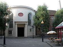
The Countess of Huntingdon's Hall is a historic church now used as venue for an eclectic range of musical and comedy performances.[92] Recent acts have included Van Morrison, Eddie Izzard, Jack Dee, Omid Djalili and Jason Manford.
The Marrs Bar is a venue for gigs and stand-up comedy.[93] Worcester has two multi-screen cinemas; the Vue Cinema complex is located in Friar Street and the Odeon in Foregate Street – both were 3D-equipped by March 2010.
The northern suburb of Northwick has the Art Deco Northwick Cinema. Built in 1938, it contains one of only two remaining interiors in Britain designed by John Alexander. The original perspective drawings are still held by RIBA. It was a bingo hall from 1966 to 1982, then empty until 1991, a music venue until 1996, and empty again until autumn 2006, when it became an antiques and lifestyle centre, owned by Grey's Interiors, which was previously located in the Tything.[94]
Worcester was home to the electronic music producer and collaborator Mike Paradinas and his record label Planet Mu, until the label moved to London in 2007.[95]
Media
Newspapers
- Berrow's Worcester Journal
- Worcester News
- Worcester Observer
Radio Stations
- BBC Hereford & Worcester
- Free Radio
- Youthcomm Radio
- Heart FM
- Sunshine Radio
- Capital Mid-Counties
In popular culture
The well-researched historical novel The Virgin in the Ice, part of Ellis Peters' The Cadfael Chronicles series, depicts Worcester at the time of the Anarchy. It begins with the words:
"It was early in November of 1139 that the tide of civil war, lately so sluggish and inactive, rose suddenly to wash over the city of Worcester, wash away half of its livestock, property and women and send all those of its inhabitants who could get away in time scurrying for their lives northwards away from the marauders". (These are mentioned as having arrived from Gloucester, leaving a long lasting legacy of bitterness between the two cities.)
Twinning and planned twinning
Worcester is twinned with the German city of Kleve, with the Parisian commune of Le Vésinet, and with its larger American namesake Worcester, Massachusetts.[96]
In February 2009 Worcester City Council's Twinning Association began discussing an application to twin Worcester with the Palestinian city of Gaza. Councillor Alan Amos introduced the application, which was passed at its first stage by a majority of 35–6,[97] but later rejected by the Executive Committee of the City of Worcester Twinning Association for lack of funding.[98]
Notable people
In birth order:
- Hannah Snell (1723–1792), famous for impersonating a man and enlisting in the Royal Marines, was born and brought up in Worcester.
- Elizabeth Blower (c. 1757/63 – post-1816), novelist, poet and actress, was born and raised in Worcester.
- Ann Hatton (1764–1838), writer of the Kemble family, was born in Worcester.
- James White (1775–1820), founder of first advertising agency in 1800 in London, was born in Worcester.
- John Mathew Gutch (1776–1861), journalist, lived with his second wife at Barbourne, a suburb north of Worcester, from 1823 until his death.
- Jabez Allies (1787–1856) a Worcestershire folklorist and antiquarian lived at Lower Wick, now part of Worcester.
- Sir Charles Hastings (1794–1866), British Medical Association founder, lived in Worcester for most of his life.
- Revd Thomas Davis, a hymn-writer born in Worcester in 1804
- Philip Henry Gosse, naturalist, was born in Worcester in 1810.
- Mrs. Henry Wood (1814–1887), writer, was born in Worcester.
- Alexander Clunes Sheriff (1816–1878), City Alderman, businessman and Liberal MP, grew up in Worcester.
- Edward Leader Williams (1828–1910), designer of the Manchester Ship Canal, was born and brought up at Diglis House in Worcester.
- Benjamin Williams Leader (1831–1923), brother of previous, landscape artist.
- Sir Thomas Brock (1847–1922), sculptor, best known for the London Victoria Memorial, was born in Worcester in 1847. Worcestershire Royal Hospital is in a road named after him.
- Vesta Tilley (1864–1952), music hall performer who adopted this stage name aged 11, was born in Worcester. She became a noted male impersonator.
- Sir Edward Elgar, composer, was born in 1857 in Lower Broadheath, just outside Worcester, and he lived in the city from the age of two. His father ran a music shop in High Street; a statue of Elgar stands near the original site. His early musical career was based around the city, and his first major work was commissioned for the Three Choirs Festival there.
- William Morris, Lord Nuffield (1877–1963), founder of Morris Motors and philanthropist, spent the first three years in Worcester.
- Geoffrey Studdert Kennedy (1883–1929, "Woodbine Willy"), poet and author, was Vicar of St Paul's Church. As an army chaplain in the First World War he would hand out Woodbine cigarettes to men in the trenches.
- Ernest Payne (1884–1961) was born in Worcester and rode for St Johns Cycling Club, winning a gold medal in team pursuit at the 1908 Summer Olympics in London.
- Sheila Scott (1922–1988), aviator, was born in Worcester.
- Louise Johnson (1940–2012), biochemist and protein crystallographer, was born in Worcester.[99]
- Timothy Garden, Baron Garden (1944–2007), Air Marshal and Liberal Democrat politician, was born in Worcester.
- Dave Mason (born 1946), musician, singer, songwriter and guitarist, was born in Worcester.
- Lee Cornes (born 1951), comedian and actor known for television roles in Blackadder, The Young Ones and Bottom series, was born in Worcester.
- David McGreavy (born 1951, the "Monster of Worcester"), lived and committed child murders in Worcester.
- Imran Khan (born 1952), cricketer and Prime Minister of Pakistan, attended the Royal Grammar School Worcester (?-1971) and played cricket for Worcestershire County Cricket Club (1971-1976).
- Stephen Dorrell (born 1952), English Conservative politician and government member, was born in Worcester.
- Karl Hyde (born 1957), English musician, frontman of trance music group Underworld was born in Worcester.
- Donncha O'Callaghan (born 1979), Irish Rugby Union player. Joined Worcester Warriors in 2015 from Munster Rugby Irish and British and Irish Lions International
- Kit Harington (born 1986), actor, lived in Worcester attended The Chantry School and Worcester Sixth Form College. He plays the character Jon Snow in Game of Thrones.
See also
- List of Bishops of Worcester
- List of mayors of Worcester
- Worcester City Art Gallery & Museum
- Jewish Community of Worcester
Notes
- See Watts 2004, p. 700 for the Anglo-Saxon name
References
- The Elgar Trail Archived 22 August 2017 at the Wayback Machine. ELGAR. Retrieved on 2 August 2013.
- City of Worcester. "The First Settlers". Worcester City Council (Worcester), 2005.
- City of Worcester. "Vertis—The Roman Industrial Town, 1st–4th centuries A.D." Worcester City Council (Worcester), 2005.
- Roman Britain. "Vertis". Archived 11 March 2015 at the Wayback Machine
- Pevsner & Brookes 2007, p. 14
- City of Worcester. "The Late Roman and Post-Roman Settlement, 4th century – 680". Worcester City Council (Worcester), 2005.
- Attributed to Nennius. Theodor Mommsen, ed., Historia Brittonum, VI. composed after 830. Hosted at Latin Wikisource.
- David Nash Ford, The 28 Cities of Britain Archived 15 April 2016 at the Wayback Machine at Britannia, 2000.
- John Henry Newman, Lives of the English Saints: St. German, Bishop of Auxerre, Chapter X: "Britain in AD 429", p. 92. Archived 21 March 2016 at the Wayback Machine James Toovey (London), 1844.
- Stenton, Frank (1943). Anglo-Saxon England. Oxford: Oxford University Press. pp. 44, 422. ISBN 0-19-280139-2.
- Willis-Bund & Page 1924
- Willis-Bund & Page 1971b, pp. 167–173
- "ARCHA". Jewishencyclopedia.com. Archived from the original on 2 August 2018. Retrieved 23 November 2018.
- de Blois 1194, Lazare 1903
- Vincent 1994, p. 217
- "Jewish Badge". Jewishvirtuallibrary.org. Archived from the original on 6 November 2018. Retrieved 23 November 2018.
- Vincent 1994, p. 209
- Mundill 2002, pp. 58–60
- Mundill 2002, p. 42
- Mundill 2002, p. 23
- Ordinances quoted Willis-Bund & Page 1924
- See Green, in History of Worcester Volume ii.
- Quoted in Willis-Bund & Page 1924
- Willis-Bund & Page 1971a, pp. 175–179
- Atkin 2004, pp. 52–53
- Atkin 2004
- Atkin 2004, pp. 125–127
- Atkin 2004, pp. 142–143
- Atkin 2004, pp. 142–147
- "Civic Heralrdy of England and Wales – Severn Valley and the Marches". civicheraldry.co.uk. Archived from the original on 4 May 2012. Retrieved 8 January 2013.
- Atkin 1998
- Guildhall – Worcester – Worcestershire – England Archived 30 April 2015 at the Wayback Machine. British Listed Buildings. Retrieved on 2 August 2013.
- "Worcester glove-making". BBC. Archived from the original on 6 March 2012. Retrieved 18 January 2011.
- "BMA – Our history". British Medical Association. Archived from the original on 28 November 2012. Retrieved 8 January 2013.
- "University demolition work starts". BBC News. 3 January 2008. Archived from the original on 2 December 2012. Retrieved 26 January 2010.
- "The Infirmary – University of Worcester". Worcester.ac.uk. Archived from the original on 3 March 2018. Retrieved 23 November 2018.
- "History of Worcester Royal Infirmary to Be Brought Back to Life". University of Worcester. 5 November 2009. Archived from the original on 3 July 2017. Retrieved 8 January 2013.
- Tim Whittle: Fuelling the Wars - PLUTO and the Secret Pipeline Network 1936 to 2015, published 2017, p. 223. ISBN 9780992855468
- The Buildings of England – Worcester, Penguin, 1968
- Lauren Rogers (21 September 2007). "Beaten Tory Keeps A Low Profile". Worcester News. Archived from the original on 15 November 2007. Retrieved 30 September 2007.
- "Election 2008 Worcester council". BBC News Online. 19 April 2008. Archived from the original on 6 May 2008. Retrieved 8 January 2010.
- Conservatives
- Labour
- Green Party
- Liberal Democrats
- "Michael Foster: Electoral history and profile". The Guardian. London. Retrieved 8 January 2010.
- "Extreme weather in Herefordshire and Worcestershire". BBC. 20 September 2010. Archived from the original on 2 December 2012. Retrieved 12 January 2012.
- "Great Floods". Webbaviation.co.uk. Archived from the original on 12 June 2018. Retrieved 12 June 2018.
- "Flooding". Bbc.co.uk. Archived from the original on 21 June 2018. Retrieved 12 June 2018.
- Hill, Amelia (20 December 2010). "Chill record: Worcester town Pershore encounters drop to -19C". The Guardian. London. Archived from the original on 21 October 2016. Retrieved 14 January 2012.
- "TORRO – British Weather Extremes: Daily Maximum Temperatures". Torro.org.uk. Archived from the original on 6 November 2018. Retrieved 23 November 2018.
- "Climate United Kingdom – Climate data". Tutiempo.net. Archived from the original on 12 December 2018. Retrieved 23 November 2018.
- "Records and Averages". Msn.com. Archived from the original on 30 June 2017. Retrieved 23 November 2018.
- "SWJCS GREEN BELT REVIEW July 2010" (PDF). Swdevelopmentplan.org. Archived (PDF) from the original on 3 March 2018. Retrieved 2 March 2018.
- "Green belt statistics". Gov.uk. Archived from the original on 3 July 2018. Retrieved 2 March 2018.
- Good Stuff IT Services. "Worcester – UK Census Data 2011". Ukcensusdata.com. Archived from the original on 31 October 2019. Retrieved 31 October 2019.
- "Worcester United Reformed Church". Worcester United Reformed Church. Archived from the original on 11 October 2016. Retrieved 23 November 2018.
- Chambers Dictionary, 12th edition.
- "Spirit of Enterprise Exhibition – Glove Making". Worcester Museums and Galleries. Archived from the original on 17 February 2012. Retrieved 14 February 2012.
- Michael Grundy (21 June 2010). "This week in 1980". Worcester News. Archived from the original on 3 May 2015. Retrieved 8 January 2013.
- "Worcester Porcelain Museum". Worcester Porcelain Museum. Archived from the original on 19 September 2010. Retrieved 27 September 2010.
- "Morganite Crucible". Archived from the original on 1 August 2015. Retrieved 23 November 2019.
- "Mazak History". Yamazaki Mazak Corporation. Archived from the original on 2 April 2015. Retrieved 29 March 2015.
- [https://www.worcester-bosch.co.uk/about/history Archived 3 February 2019 at the Wayback Machine>
- "The tale of Cecil's life so far". Worcester News. 10 September 2012. Archived from the original on 28 January 2019. Retrieved 31 October 2019.
- "Kays Heritage Group". Kays Heritage Group. 19 May 2012. Archived from the original on 6 January 2013. Retrieved 8 January 2013.
- "At least £500000 to be pumped into sprucing up Worcester City Centre". Worcester News. December 2014. Archived from the original on 3 August 2017. Retrieved 4 June 2017.
- Jones, Kath (2006). Keep right on to the end of the road. Cambridge: Vanguard. p. 68. ISBN 9781843862857.
- "Church of St Helen, Worcester, Worcestershire". British Listed Buildings. Archived from the original on 1 February 2017. Retrieved 19 January 2017.
- "National Sustainability Award". Thehiveworcester.org. June 2012. Archived from the original on 25 September 2018. Retrieved 23 November 2018.
- "CIBSE Building Performance Awards". Thehiveworcester.org. 2013. Archived from the original on 3 August 2017. Retrieved 23 November 2018.
- "Worcester's Gheluvelt Park given listed status". Bbc.co.uk. 2015. Archived from the original on 24 December 2018. Retrieved 23 November 2018.
- "The Elgar Route – A walk around Elgar's Worcester" (PDF). Visitworcestershire.org. Archived (PDF) from the original on 13 May 2013.
no 10, the Elgar Brothers' music shop. Its location is marked by a shop-front plaque unveiled in 2003.
- Fraser, Antonia (1973). Cromwell Our Chief of Men. p. 387. ISBN 0-09-942756-7.
- Worcestershire County Council (11 November 2014). "The A4440 Worcester Southern Link Road Improvements | The A4440 Worcester Southern Link Road Improvements | Worcestershire County Council". Worcestershire.gov.uk. Archived from the original on 23 May 2019. Retrieved 31 October 2019.
- Richard Morriss The Archaeology of Railways, 1999 Tempus Publishing, Stroud, p. 89.
- Richard Morriss The Archaeology of Railways, 1999 Tempus Publishing, Stroud. Plate 93 p147
- "Travelling to Worcestershire". Visit Worcestershire. Herefordshire and Worcestershire Chamber of Commerce. 2017. Archived from the original on 18 October 2017. Retrieved 4 June 2017.
- County council leadership votes through park and ride axe Archived 29 November 2014 at the Wayback Machine, Worcester News, 10 June 2014.
- "Worcester Park and Ride". Worcestershire County Council. 2016. Archived from the original on 18 July 2016.
- "Sustrans". Sustrans.org.uk. Archived from the original on 7 October 2019. Retrieved 7 October 2019.
- "Worcester – A Severn Bridge at Diglis Lock and Link to Powick". Sustrans. Archived from the original on 1 October 2012. Retrieved 22 March 2012.
- "Worcester Hockey Club". Worcesterhockey.co.uk. Archived from the original on 25 October 2014. Retrieved 17 October 2014.
- "Three Choirs Festival – Programme & Tickets". 3choirs.org. Archived from the original on 15 August 2014. Retrieved 18 July 2014.
- "Worcester Festival". Worcesterfestival.co.uk. Archived from the original on 26 July 2014. Retrieved 18 July 2014.
- 'New talent to shine' Worcester Standard. 1 November 2012. Retrieved 16 September 2013.
- "Worcester's Victorian Christmas Fayre". Worcester Victorian Christmas Fayre. Worcester City Council. Archived from the original on 6 March 2019. Retrieved 2 March 2019.
- "2012 Worcester Beer, Cider and Perry Festival". Worcester Beer, Cider and Perry Festival. Archived from the original on 20 July 2013. Retrieved 8 January 2013.
- James Connell (15 August 2011). "Cheers! Beer festival is the biggest and best yet". Worcester News. Retrieved 8 January 2013.
- "Ann Julia Kemble Hatton (1764–1848)". Literary Heritage West Midlands. Archived from the original on 17 June 2013. Retrieved 8 January 2013.
- Maitland, Sarah (1986). Vesta Tilley. London, UK: Virago Press. p. 14. ISBN 0-86068-795-3.
- "About Us Worcester Live". Worcester Live. Archived from the original on 12 January 2013. Retrieved 8 January 2013.
- "Marr's Bar". 30 August 2012. Archived from the original on 5 January 2013. Retrieved 8 January 2013.
- "Royal Institute of British Architects". Royal Institute of British Architects. Retrieved 7 January 2013.
- "Planet MU Records Limited". Companies House. Archived from the original on 10 November 2017. Retrieved 4 June 2017.
- Lauren Rogers (31 January 2008). "City to fight US twin 'snub'". Worcester News. Archived from the original on 10 August 2009. Retrieved 6 May 2009.
- Richard Vernalls (26 February 2009). "Worcester could be twinned with Gaza City". Worcester News. Archived from the original on 1 March 2009. Retrieved 27 February 2009.
- James Connell (10 March 2009). "Gaza twinning the decision is in". Worcester News. Archived from the original on 23 August 2009. Retrieved 9 July 2009.
- Garman, Elspeth F. (7 January 2016). "Johnson, Dame Louise Napier (1940–2012), biophysicist and structural biologist". Oxford Dictionary of National Biography (online ed.). Oxford University Press. doi:10.1093/ref:odnb/105683. Archived from the original on 2 March 2016. Retrieved 23 November 2018. (Subscription or UK public library membership required.)
General Worcester sources
- Willis-Bund, J W; Page, William, eds. (1971a). "Hospitals: Worcester". A History of the County of Worcester: Volume 2. London: British History Online. pp. 175–179. Retrieved 20 May 2018.CS1 maint: ref=harv (link)
- Willis-Bund, J W; Page, William, eds. (1971b). "Friaries: Worcester". A History of the County of Worcester: Volume 2. London: British History Online. pp. 167–173. Retrieved 13 May 2018.CS1 maint: ref=harv (link)
- Willis-Bund, J W; Page, William, eds. (1924). "The city of Worcester: Introduction and borough". A History of the County of Worcester: Volume 4. London: British History Online. pp. 376–390. Retrieved 20 May 2018.CS1 maint: ref=harv (link)
- Pevsner, Nikolaus; Brookes, Alan (2007), "Worcester", Worcestershire, The Buildings of England (Revised ed.), London: Yale University Press, pp. 669–778, ISBN 9780300112986, OL 10319229MCS1 maint: ref=harv (link)
- Tuberville, T. C. (1852), Worcestershire in the nineteenth century., London: Longman, Brown, Green, and Longmans, LCCN 03006251, OCLC 9095242, OL 7063181MCS1 maint: ref=harv (link)
Sources: Medieval history
- Baker, Nigel; Holt, Richard (1996). "The City of Worcester in the Tenth Century". In Brooks, Nicholas; Cubitt, Catherine (eds.). St. Oswald of Worcester: Life and Influence. London, UK: Leicester University Press. ISBN 9780567340313.CS1 maint: ref=harv (link)
- Vincent, Nicholas (1994). "Two Papal Letters on the Wearing of the Jewish Badge, 1221 and 1229". Jewish Historical Studies. 34: 209–24. JSTOR 29779960.CS1 maint: ref=harv (link)
- Mundill, Robin R (2002). England's Jewish Solution: Experiment and Expulsion, 1262–1290. Cambridge University Press. ISBN 978-0-521-52026-3.CS1 maint: ref=harv (link)
- de Blois, Peter (1194). "Against the Perfidy of the Jews". Medieval Sourcebook. University of Fordham.
A treatise addressed to John Bishop of Worcester, probably John of Coutances who held that See, 1194-8.
CS1 maint: ref=harv (link) - Lazare, Bernard (1903), Antisemitism, its history and causes., New York: The International library publishing co., LCCN 03015369, OCLC 3055229, OL 7137045MCS1 maint: ref=harv (link)
Sources: Civil War
General sources
- Watts, Victor Ernest, ed. (2004). The Cambridge Dictionary of English Place-Names. Cambridge University Press. ISBN 9781107196896.CS1 maint: ref=harv (link)
Further reading
- John Britton; et al. (1814), "City of Worcester", Worcestershire, Beauties of England and Wales, 15, London: J. Harris
- "Worcester", Black's Picturesque Tourist and Road-book of England and Wales (3rd ed.), Edinburgh: Adam and Charles Black, 1853CS1 maint: ref=harv (link)
- "Worcester", Great Britain (4th ed.), Leipsic: Karl Baedeker, 1897, OCLC 6430424CS1 maint: ref=harv (link)
External links
![]()
| Wikisource has the text of a 1911 Encyclopædia Britannica article about Worcester. |
| Wikivoyage has a travel guide for Worcester. |
Districts of the West Midlands Region | ||
|---|---|---|
| Herefordshire | 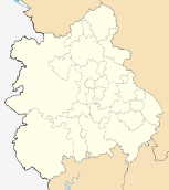 | |
| Shropshire |
| |
| Staffordshire |
| |
| Warwickshire |
| |
| West Midlands |
| |
| Worcestershire |
| |
| Authority control |
|
|---|