River Wye
The River Wye (Welsh: Afon Gwy) is the fifth-longest river in the UK, stretching some 215 kilometres (134 miles) from its source on Plynlimon in mid Wales to the Severn estuary. For much of its length the river forms part of the border between England and Wales. The Wye Valley (lower part) is an Area of Outstanding Natural Beauty.[1][2] The Wye is important for nature conservation and recreation.
| River Wye | |
|---|---|
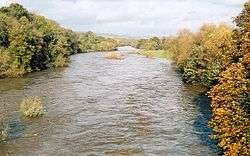 The Wye at Hay-on-Wye | |
| Native name | Afon Gwy / River Wye |
| Location | |
| Country | Wales, England |
| Physical characteristics | |
| Source | |
| ⁃ location | Plynlimon |
| ⁃ coordinates | 52°28′5.170″N 3°45′56.282″W |
| ⁃ elevation | 690 m (2,260 ft) |
| Mouth | |
⁃ location | Chepstow, Severn Estuary |
⁃ coordinates | 51°36′36.086″N 2°39′42.423″W |
⁃ elevation | 0 m (0 ft) |
| Length | 215 km (134 mi) |
| Basin size | 4,136 km2 (1,597 sq mi) |
| Basin features | |
| Tributaries | |
| ⁃ left | River Lugg, Afon Edw, Afon Elan more |
| ⁃ right | River Trothy, River Monnow, Dulas Brook, more |
.jpeg)
Etymology
The meaning of the name is not clear. Possibly the earliest reference to the name is Guoy in Nennius' early 9th Century Historia Brittonum and the modern Welsh name is Gwy. The Wye was much later given a Latin name Vaga, an adjective meaning 'wandering'.[3][4][5] The Tithe map references a Vagas Field in both Whitchurch and Chepstow.[6] Philologists such as Edward Lye and Joseph Bosworth in the 18th and early 19th centuries[7] suggested an Old English derivation from wæg, "wave".
Description
The source of the Wye is in the Welsh mountains at Plynlimon. It flows through or past several towns and villages including Rhayader, Builth Wells, Hay-on-Wye, Hereford (the only city on the River Wye), Ross-on-Wye, Symonds Yat, Monmouth and Tintern, meeting the Severn estuary just below Chepstow. Its total length is 134 miles (216 km).[8] The lower 16 miles (26 km) of the river from Redbrook to Chepstow forms the border between England and Wales.
Conservation
| Site of Special Scientific Interest | |
| Grid reference | ST544912 to SO230429 |
|---|---|
| Interest | Biological/Geological |
| Area | England: 1,159.6 ha (2,865 acres) Wales: 245.2 ha (606 acres) Total: 1,404.8 ha (3,471 acres) |
| Notification | 1978 |
| Natural England website | |
The River Wye is protected by two Sites of Special Scientific Interest, one covering the Upper Wye (Gwy Uchaf) above Hay-on-Wye,[9] and one covering the Lower Wye (Gwy Isaf) downstream to Chepstow.[10] The criteria for inclusion of the river as an SSSI include geology, topography, flora, mammals, invertebrates, fish and birdlife, as the river and its tributaries constitute a large linear ecosystem. The Lower Wye SSSI is itself divided into seven units of assessment set by Natural England, and administrative responsibilities are shared between the councils of Powys, Herefordshire, Gloucestershire, and Monmouthshire.[10] The Wye abuts a range of other SSSIs in England and Wales, including the Upper Wye Gorge and Lower Wye Gorge.
It is also a Special Area of Conservation[11][12] and one of the most important rivers in the UK for nature conservation. It is an important migration route and wildlife corridor, as well as a key breeding area for many nationally and internationally important species. The river supports a range of species and habitats covered by European Directives and those listed under Schedule 5 of the Wildlife and Countryside Act 1981.[10] In Powys the river lies within the Radnorshire Environmentally Sensitive Area. Much of the lower valley is an Area of Outstanding Natural Beauty.
Salmon
The Lower Wye has been designated as a salmonid fishery under the EC Freshwater Fish Directive.[10] The Wye is largely unpolluted and used to be considered one of the best rivers for salmon fishing in the United Kingdom, outside Scotland. In the 1980s and 1990s salmon in the Wye declined dramatically. In 1967 the Wye rod catch was 7,864, and as recently as 1988 it was 6,401; but by 2002 it was only 357. It is now recovering from this low in response to the extensive habitat improvement work carried out by the Wye and Usk Foundation, set up to restore the spring salmon runs. In 2015 the five-year average once again climbed above 1,000 and it is now the third best salmon river in England and Wales, surpassed only by the Tyne and Wear.
The Wye was particularly famous for its large "spring" salmon that had spent three or more years at sea before returning to spawn. They used to enter the river between January and June and sometimes reached weights of over 50 pounds (23 kg), the largest recorded being 59 lb 8 oz (27.0 kg) landed after a long fight by Miss Doreen Davey from the Cowpond Pool at Winforton on 13 March 1923. The last recorded 50 lb (23 kg) rod-caught salmon from the Wye was taken in 1963 by Donald Parrish and weighed 51 lb 8 oz (23.4 kg). Since the early 2000s the spring catch has been steadily recovering and salmon of over 35 lb (16 kg) have been reported every year since 2011.
History
The Romans constructed a bridge of wood and stone just upstream of present-day Chepstow. The River Wye has been navigable up to Monmouth since at least the early 14th century. It was improved from there to a short distance below Hereford by William Sandys in the early 1660s with locks to enable vessels to pass weirs. According to Herefordshire Council Archaeology, these were flash locks.[13] The work proved to be insufficiently substantial and in 1696 a further Act of Parliament authorised the County of Hereford to buy up and demolish the mills on the Wye and Lugg. All locks and weirs were removed, except that at New Weir forge below Goodrich, which survived until about 1815. This was paid for by a tax on the county. Weirs were removed all along the Wye in Herefordshire, making the river passable to the western boundary, and beyond it at least to Hay on Wye. A horse towing path was added in 1808, but only up to Hereford; previously, as on the River Severn, barges were man-hauled. Money was spent several times improving the River Lugg from Leominster to its confluence with the Wye at Mordiford, but its navigation is likely to have been difficult. The Wye remained commercially navigable until the 1850s, when commercial traffic moved to railways. It is still used by pleasure craft.
Navigation and sport
The Environment Agency is the navigation authority for the river. The Normal Tidal Limit (NTL) of the river is Bigsweir and navigation below this point is under the control of the Gloucester Harbour Trustees as Competent Harbour Authority. There is a public right of navigation downstream from Hay-on-Wye.[14] Canoes are generally permitted at and downstream of Glasbury, so long as they do not disturb anglers.[15]

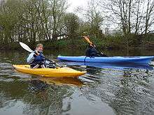
The River Wye provides for canoeing and kayaking as it has sections suitable for all ranges of skills and free access all the way downstream from Hay to Hereford and Monmouth, and the tidal Wye to Chepstow and the Severn Estuary.[16] There are a wide range of canoe hire and supervised trips, as well as campsites at key points on the river. Symonds Yat has a particularly popular series of rapids that was purchased by the British Canoe Union in 2003 to preserve the rapids for recreational use, canoe trips through the rapids stop next at Monmouth.[17] There are three rowing clubs on the river at Hereford, Ross-on-Wye and Monmouth. Annual regattas are held at Ross-on-Wye and Monmouth for rowers and scullers of all abilities, next to the local rowing club. In 2017 more than 600 people took to the River Wye in inflatables ranging from dinghies to paddling pools during the event WYE FLOAT, opened by former Olympic ski jumper Eddie the Eagle.[18]
Walkers can enjoy the Wye Valley Walk which follows the route of the River Wye from Coed Hafren, near Plynlimon, to Chepstow along a series of well-maintained way-marked paths. A viewpoint near The Biblins on the Wye is known as 'Three Counties View', the meeting place of the counties of Herefordshire, Gloucestershire and Monmouthshire.
Tributaries
The Wye's tributaries include the river Lugg, Elan, Dulas, Irfon, Marteg, Monnow, Trothy, Ithon, Llynfi, Letton Lake, Tarennig (the Wye's first tributary) and Bidno. A fuller list is available at the relevant section of the list of rivers of Wales
2020 floods
In February 2020, Wales and parts of England endured extremely heavy rainfall from Storm Dennis, following shortly after Storm Ciara. The central part of South Wales was particularly affected. The river over-topped its banks and caused flash flooding in several areas including Hay-on-Wye, Hereford, Ross-on-Wye and Monmouth. Much of Hereford was flooded with homes inundated. Churches and leisure centres were opened to accommodate evacuated residents. The river at Monmouth reached its highest level ever recorded.[19][20]
Cultural references
The Romantic poet William Wordsworth includes an apostrophe to the Wye in his famous poem "Lines Written a Few Miles Above Tintern Abbey" published 1798 in Lyrical Ballads:
How oft, in spirit, have I turned to thee,
O sylvan Wye! thou wanderer thro' the woods,
How often has my spirit turned to thee!
Nelson travelled down the Wye in 1802, along with Lady Hamilton and her husband, Sir William Hamilton.[21] They sailed from Ross-on-Wye to Monmouth, to be greeted by a cannonade and the band of the Monmouthshire Militia playing See, the Conquering Hero Comes.[21] Nelson expressed surprise that he was known at "such a little gut of a river as the Wye".[21]
Views of the river
 Ross-on-Wye, Herefordshire
 Ross-on-Wye
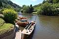 Water transport at Symonds Yat
 St Peter's Church, Dixton
 Landscape with View on the River Wye by Thomas Jones
 Eagle's Nest, Wyndcliff
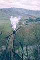 A steam-hauled stone train crossing the River Wye after departing from Tintern railway station in 1963
Bridges on the river
 The old railway bridge at Redbrook
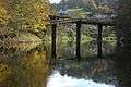
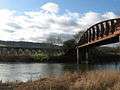 Monmouth Viaduct and Duke of Beaufort Bridge at Monmouth
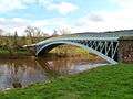 Bigsweir Bridge
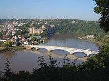
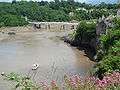 Chepstow Castle and bridge
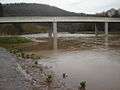 Brockweir Bridge
 Biblins Bridge
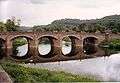 Wye Bridge, Monmouth
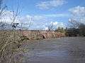 Wilton Bridge, Ross on Wye
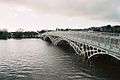 Chepstow Bridge at very high tide
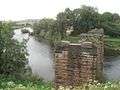 Backney Bridge, near Backney Halt, demolished under the Beeching Axe.
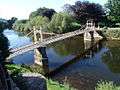 Victoria Bridge, Hereford
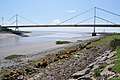 River Wye estuary and M48 Wye road bridge
See also
- Wye Valley
- Wye Valley Walk
- Wye Valley Railway
- List of rivers of England
- List of rivers of Wales
- List of bridges in Wales
- South Herefordshire and Over Severn
References
- "Natural England information on AONBs and map". Natural England. Retrieved 5 October 2012.
- "Natural England information on Wye Valley AONB". Natural England. Archived from the original on 30 August 2014. Retrieved 5 October 2012.
- Richard Lovell Edgeworth; Maria Edgeworth (1816). Readings on Poetry. R. Hunter. pp. 3.
- Izaak Walton (1833). The Complete Angler ; Or, Contemplative Man's Recreation; Being a Discourse on Rivers, Ponds, Fish and Fishing. With Lives and Notes. Peter Pauper Press. p. 249.
- J. Thompson (12 March 2015). John Thelwall: Selected Poetry and Poetics. Springer. p. 338. ISBN 978-1-137-34483-0.
- The Tithe map (1844)
- Bosworth, Joseph A Dictionary of the Anglo-saxon Language (1838)
- Sue Owen; et al. (2005). Colin Pooley (ed.). Rivers and the British Landscape. Carnegie Publishing. ISBN 978-1-85936-120-7.
- "Countryside Council for Wales Landscape & wildlife statement for River Wye (Upper Wye) / Afon Gwy (Gwy Uchaf)". Countryside Council for Wales. Archived from the original on 12 November 2013. Retrieved 18 August 2012.
- "Natural England SSSI information on River Wye (Lower Wye) or Afon Gwy (Gwy Isaf) SDdGA – citation, maps and unit details". Natural England. Retrieved 18 August 2012.
- "Information on River Wye Special Area of Conservation designation". DEFRA. Retrieved 20 September 2012.
- "Joint Nature Conservation Committee Listing of Special Areas of Conservation". DEFRA. Retrieved 20 September 2012.
- I. Cohen. "The Non-tidal Wye and its Navigation (from Transactions of the Woolhope Naturalists Field Club, 1958 pg 86–94)". Retrieved 9 December 2006.
- "Wye canoe?" (PDF). Environment Agency.
Upstream of Hay Bridge, the river can provide some good canoeing water but there is no established public right of navigation.
- "Canoeing in the Area". Hay-on-Wye Tourist Information Bureau. Retrieved 30 November 2013.
- "Boating along the River Wye". Waterscape. Retrieved 10 April 2012.
- "River rapids sold to canoeists". BBC News. 15 March 2003. Retrieved 22 May 2010.
- "PHOTOS: 2017 Wye Float".
- [www.herefordtimes.com "Storm Dennis: Herefordshire flooding updates", Hereford Times, 18 February 2020]
- [https://www.bbc.co.uk/news/uk-wales-51540009 "Storm Dennis: Flood warnings as River Wye reaches record high", BBC News, 18 February 2020
- Kissack 1975, p. 251.
Sources
- Kissack, Keith (1975). Monmouth: The Making of a County Town. Chichester: Phillimore. ISBN 9780850332094. OCLC 255539468.
Further reading
- Cohen, I. "The non-tidal Wye and its navigation", Trans. Woolhope Nat. Fld. Club, 34 (1955), pp. 83–101.
- Stockinger, V. (1996) The Rivers Wye and Lugg Navigation: A Documentary History 1555–1951, Logaston Press, ISBN 978-18-738-27895
- King, P. "The River Teme and Other Midlands River Navigations", Journal of Railway and Canal Historical Society, 35, 50 (July 2006), pp. 350–1.
- Chisholm, Hugh, ed. (1911). . Encyclopædia Britannica (11th ed.). Cambridge University Press.
External links
| Wikimedia Commons has media related to River Wye. |
- The River Wye described from Source to Sea
- Natural England (SSSI information)
- Countryside Council for Wales (SSSI information)
- The Wye and Usk Foundation conservation charity
- Canoeists' guide to the River Wye
- River Wye Preservation Trust
Transport in Monmouthshire | ||
|---|---|---|
| Road |
|  |
| Bus |
| |
| National Cycle Network |
| |
| Railway lines |
| |
| Railway stations |
| |
| Waterways |
| |
| Authority control |
|
|---|