Huaynaputina
Huaynaputina (/waɪnəpʊˈtiːnə/ WY-nə-puu-TEE-nə; Spanish: [wajnapuˈtina]) is a stratovolcano in a volcanic upland in southern Peru. Part of the Central Volcanic Zone of the Andean Volcanic Belt, it is the product of the subduction of the oceanic Nazca tectonic plate beneath the continental part of the South American tectonic plate at a rate of 10.3 centimetres per year (4.1 in/year). Huaynaputina is a large volcanic crater, lacking an identifiable mountain profile, with an outer stratovolcano and three younger volcanic vents. The vents of Huaynaputina form a north-northwest–south-southeast trend.
| Huaynaputina | |
|---|---|
 View of the crater and part of the nearby valley. | |
| Highest point | |
| Elevation | ≈4,850 metres (15,900 ft) [1] |
| Listing | List of volcanoes in Peru |
| Coordinates | 16.608°S 70.85°W [1] |
| Naming | |
| Native name | Waynaputina (Quechua) |
| Geography | |
 Huaynaputina Location in Peru | |
| Location | Peru |
| Parent range | Andes |
| Geology | |
| Age of rock | 500,000 years |
| Mountain type | Stratovolcano |
| Volcanic arc/belt | Central Volcanic Zone |
| Last eruption | February to March 1600 |
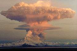
The volcano erupted several times during the Holocene, the largest eruption took place in the year 1600. The 1600 eruption was the largest historical eruption in South America, measuring 6 on the Volcanic Explosivity Index. It occurred on 19 February and continued with a series of events into March. Witnessed by the people of the city of Arequipa, its impact in the region was severe, wiping out vegetation and burying the surroundings with 2 metres (6.6 ft) of volcanic rock; it also damaged infrastructure and economic resources. The eruption had significant effects on Earth's climate, decreasing temperatures in the Northern Hemisphere, causing floods, famines and cold waves in numerous places, and depositing several million tons of acid. The climate disruption caused social upheaval in many countries such as Russia and may have played a role in the onset of the Little Ice Age.
Huaynaputina has not erupted since 1600. Today there are fumaroles in Huaynaputina's amphitheatre, and hot springs occur in the region, some of which have been associated with Huaynaputina. The volcano lies in a remote region, where there is little human activity. Still, there are about 30,000 people living in the surrounding area, with another 800,000 in Arequipa. If Huaynaputina underwent a similar eruption to its 1600 event, it would likely lead to a significantly higher death toll and cause substantial socioeconomic disruption. The Peruvian Geophysical Institute announced in 2017 that Huaynaputina would be monitored by the future Southern Volcanological Observatory.
Name
The name Huaynaputina was given to the volcano after its 1600 eruption[2] and is also spelled Huayna Putina or Guagua Putina.[3] According to one translation, Huayna means "new" and Putina means "fire throwing mountain," the full name meant to suggest the aggressiveness of its volcanic activity[4] but also of the 1600 eruption being the first one at that volcano.[5] Two other translations are "young boiling one" – perhaps a reference to earlier eruptions – or "where young were boiled," which may refer to human sacrifices.[6] Other names for the volcano include Chequepuquina, Chiquimote, Guayta, Omate and Quinistaquillas.[1] Reportedly, the volcano El Misti was sometimes confused with and thus referred to mistakenly as Huaynaputina.[3]
Geography
The volcano is part of the Central Volcanic Zone of the Andes. Other volcanoes in this volcanic zone from northwest to southeast include Sara Sara, Coropuna, Ampato, Sabancaya, El Misti, Ubinas, Ticsani, Tutupaca and Yucamane.[7] Ubinas is the most active volcano in Peru,[8] and El Misti, Sabancaya, Ticsani, Tutupaca, Ubinas and Yucamane (as well as Huaynaputina) have been active in historical time while Sara Sara, Coropuna, Ampato, Casiri and Chachani are considered to be dormant volcanoes.[9] Most volcanoes of the Central Volcanic Zone are large composite volcanoes that can remain active over the span of several million years,[10] but there are also conical stratovolcanoes with shorter lifespans.[9]
Huaynaputina is located in the Omate and Quinistaquillas Districts,[11] which lie within General Sánchez Cerro Province[12] in the Moquegua Region of southern Peru.[13] The town of Omate lies 16 kilometres (10 mi) southwest of Huaynaputina,[6] while the cities of Moquegua and Arequipa are located 65 km (40 mi) south-southwest and 80 km (50 mi) north-northwest of the volcano.[11]
There is little human activity in the area near the volcano.[14] The region is generally remote and the terrain extreme, and thus the area around Huaynaputina is not easily accessible.[8] A cattle grazing footpath leads from Quinistaquillas to the volcano,[11] and it is possible to approach the volcano over surrounding ash plains.[15]
Structure
Huaynaputina lies at an elevation of about 4,850 metres (15,910 ft).[1] It consists of an outer composite volcano[2] (or stratovolcano)[13] and three younger volcanic vents nested within a 2.5-kilometre (1.6 mi) wide[2] and 400-metre (1,300 ft) deep[7] amphitheatre.[2] This horseshoe-shaped[16] structure is set in the older volcano[2] at an elevation of 4,400 m (14,400 ft)[17] and opens eastwards.[18] The amphitheatre lies at the margin of[12] a rectangular[19] high plateau[12] that is covered by about 2-metre-thick (6.6 ft)[20] ash over an area of 50 square kilometres (19 sq mi).[19] In general, the volcano has modest dimensions and rises less than 600 m (0.37 mi) above the surrounding terrain,[21] but the products of the volcano's 1600 eruption cover much of the region to this day[22] especially west, north and south from the amphitheatre;[23] these include pyroclastic flow dunes that crop out from underneath the tephra.[24] Deposits from the 1600 eruption and previous events also crop out within the amphitheatre walls.[25] Another southeastward-opening landslide scar lies just north of Huaynaputina.[26]
One of these funnel-shaped vents[27] is a 70-metre (230 ft) trough that cuts into the amphitheatre, which appears to be a remnant of a fissure vent. The second appears to have been about 400-metre (1,300 ft) wide before the development of the third vent, which has mostly obscured the first two. The third vent is steep-walled, with a depth of 80 m (260 ft), and contains a 200-metre (660 ft) wide pit within a small mound that is in part nested within the second vent. This third vent is surrounded by concentric faults,[28] and at least one of the vents has been described as an ash cone.[29] In addition, a fourth vent lies on the southern slope of the composite volcano outside of the amphitheatre[2] and has been described as a maar.[17] It is about 70-metre (230 ft) wide and 30-metre (98 ft) deep and appears to have formed during a phreatomagmatic eruption.[28] These vents lie at an elevation of about 4,200 m (13,800 ft), making them among the highest vents of a Plinian eruption in the world.[2]
Slumps have buried parts of the amphitheatre.[30] Dacitic dykes crop out within the amphitheatre[31] and are aligned along a northwest–south trending lineament that the younger vents are also located on.[32] These dykes and a dacitic lava dome of similar composition were formed before the 1600 eruption.[28] A number of faults with recognizable scarps occur within the amphitheatre and have offset the younger vents;[33] some of these faults existed before the 1600 eruption while others were activated during the event.[34]
Surroundings
The terrain west of the volcano is formed by the high plateau[2] at an elevation of about 4,600 m (15,100 ft),[21] which north of Huaynaputina features the volcano Ubinas and the depression of Laguna Salinas[7] while the peaks Cerro El Volcán and Cerro Chen are situated south of it.[2] Cerro El Volcán (a lava dome)[35] and Cerro Las Chilcas (another small lava dome[36]) lie 3 km (1.9 mi) south from Huaynaputina.[19] Northeast-east of Huaynaputina,[26] the terrain drops off steeply (2.3 km or 1.4 mi vertically and 6 m or 20 ft horizontally[21]) into the Río Tambo valley, which runs southward and then westward as it rounds Huaynaputina. Some tributary valleys join the Río Tambo from Huaynaputina; clockwise from the east these are the Quebradas Huaynaputina, Quebrada Tortoral, Quebrada Aguas Blancas and Quebrada del Volcán.[2] The Río Tambo eventually flows southwestward into the Pacific Ocean.[10]
Geology

The oceanic Nazca tectonic plate is subducting at a rate of 10.3 centimetres per year (4.1 in/year) beneath the continental part of the South American tectonic plate, and this process is responsible for volcanic activity and the uplift of the Andes mountains and Altiplano plateau. The subduction is oblique, leading to strike-slip faulting.[8] Volcanic activity does not occur along the entire length of the Andes; where subduction is shallow, there are gaps with little volcanic activity. Between these gaps lie volcanic belts: the Northern Volcanic Zone, the Central Volcanic Zone, the Southern Volcanic Zone and the Austral Volcanic Zone.[37]
About 400 Pliocene-Quaternary volcanoes can be found in Peru,[11] with Quaternary activity limited to the southern part of the country,[9] which is part of the Central Volcanic Zone.[38] There, volcanic activity has since the Jurassic moved from the present-day coast region where remnants persist in the Cordillera de la Costa eastward into the actual Andes[11] and the present-day volcanic arc, where it is defined by stratovolcanoes.[18] Many Peruvian volcanoes are remote and difficult to access; thus volcanic activity there is poorly studied.[38]
The basement underneath Huaynaputina is formed by almost 2-kilometre-thick (1.2 mi) sediments and volcanic intrusions of Paleozoic to Mesozoic age[31] including the Yura Group[39] as well as the Cretaceous Matalaque Formation of volcanic origin.[40] During the Tertiary, these were overlaid by a total of 300–500 m-thick (0.19–0.31 mi) deposits from the ignimbritic Capillune, Llallahui[8] and Sencca Formations. The emplacement of the Capillune Formation continued into the earliest Pliocene; subsequently the Plio-Pleistocene Barroso Group was deposited, which includes the composite volcano that hosts Huaynaputina[31] but also ignimbrites that appear to come from calderas. One such caldera is located just south of Huaynaputina. The late Pleistocene to Holocene volcanoes have been classified as the Arequipa Volcanics.[18]
Local
The vents of Huaynaputina form a north–northwest-south–southeast trend, which also encompasses the neighbouring volcanoes Ubinas and Ticsani,[2] the former of which is a typical stratovolcano while Ticsani resembles Huaynaputina in structure.[18] The trend also constitutes a volcanic field located behind the major volcanic arc and associated with faults at the margin of the Río Tambo graben[41] as well as regional strike-slip faults.[42] In addition, the volcanic rocks produced by these volcanoes have similar compositions,[8] and recent seismic and volcanic activity at Ubinas and Ticsani indicate that they share a magma reservoir.[43] The faults associated with the volcanic complex have influenced the evolution of the constituent volcanoes including Huaynaputina[42] by acting as conduits for ascending magma especially at fault intersections.[44] A 40-by-60-kilometre (25 mi × 37 mi) magma reservoir may underpin this volcanic system.[45]
Composition
The eruption products of the 1600 eruption are dacites, which define a calc-alkaline,[46] potassium-rich suite;[47] the geochemistry of the 1600 rocks has also been described as adakitic.[48] The 1600 rocks also contain rhyolite inclusions[47] and a rhyolite matrix.[49] Phenocrysts include biotite, chalcopyrite, hornblende, ilmenite, magnetite and plagioclase;[49] amphibole, apatite and pyroxene have been reported as well.[50] Aside from new volcanic rocks, Huaynaputina in 1600 also erupted material that is derived from rocks underlying the volcano, including sediments[51] and older volcanic rocks, both of which were hydrothermally altered.[16] Andesite has also been found at Huaynaputina.[52] The Huaynaputina pumices have a white colour.[16]
A large amount of sulfur appears to have been carried in a volatile phase associated with the magma rather than in the magma proper.[49] An even larger amount of sulfur may have originated from a relic hydrothermal system that underpins the volcano, and whose accumulated sulfur would have been mobilized by the 1600 eruption;[53] some contradictions between the sulfur yield inferred from ice core data and these inferred from the magma composition can be resolved this way.[54] The amount of volatiles in the magma appears to have decreased during the course of the 1600 eruption, indicating that the magmas originated either in two separate magma chambers or from one zoned magma chamber. This compositional change may explain changes in the eruption phenomena during the course of the 1600 activity[55] as the "Dacite 1" rocks erupted early during the 1600 event were more buoyant and contained more gas and thus drove a Plinian eruption, while the latter "Dacite 2" rocks were more viscous and only generated Vulcanian eruptions.[56] Crustal interactions and crystal fractionation processes were involved in the genesis of the magmas as well,[57] with the so-called "Dacite 1" geochemical suite forming deep in the crust, while the "Dacite 2" geochemical suite appears to have interacted with the upper crust.[58]
The rocks had a temperature of about 780–815 °C (1,436–1,499 °F) when they were erupted,[59] with the "Dacite 1" being hotter than the "Dacite 2".[60] Their formation may be stimulated by the entry of mafic magmas into the magmatic system;[55] such an entry of new magma in a volcanic system is often the trigger for explosive eruptions.[58] The magmas erupted early during the 1600 event (in the first stage of the eruption) appear to have originated from depths of more than 20 km (12 mi);[53] petrological analysis indicates that some magmas came from depths greater than 15–25 km (9–16 mi) and others from shallower depths of about 4–6 km (2.5–3.7 mi).[39] While an older hypothesis by de Silva and Francis held that the entry of water into the magmatic system may have triggered the eruption,[61] a more recent viewpoint argues that the entry of new dacitic magma into a pre-existent dacitic magma system triggered the 1600 eruption; furthermore movement of deep andesitic magmas that had generated the new dacite produced movements within the volcano.[62]
Climate and vegetation
Between 4,000–5,000 metres (13,000–16,000 ft) in elevation mean temperatures are about 6 °C (43 °F) with cold nights,[63] while at Omate, mean temperatures reach 15 °C (59 °F) with little seasonal variation. Precipitation averages 154.8 millimetres per year (6.09 in/year), falling mainly during a summer wet season between December and March.[64] This results in an arid climate, where little erosion occurs and volcanic products are well preserved.[21] Vegetation in the area of Huaynaputina is scarce, and on the pumice deposits from the 1600 eruption it only occurs during the wet season. Cacti can be found on rocky outcrops and valley bottoms.[65]
Eruption history
After the Miocene, the Pastillo volcanic complex developed in the form of half-a-kilometre-thick (0.3 mi) andesitic rocks; the ancestral composite volcano that holds Huaynaputina is part of the Pastillo volcanic complex[66] and appears to be of Miocene to Pleistocene age.[18] It underwent sector collapses and glacial erosion, which altered its appearance and left traces on its flanks. The amphitheatre which contains the Huaynaputina vents formed probably not as a caldera but either a glacial cirque,[31] a sector collapse scar[67] or another kind of structure that was altered by fluvial and glacial erosion.[41] Other extinct volcanoes in the area have similar amphitheatre structures.[31] It is likely that the development of the later Huaynaputina volcano within the composite volcano is coincidental,[31] although a similar tectonic stress field controlled the younger vents.[28]
Recently emplaced, postglacial dacite bodies occur in the Huaynaputina area,[2] some of which probably formed shortly before the 1600 eruption.[68] Cerro Las Chilcas also predates the 1600 eruption[19] and appears to be the earliest volcanic centre in the area.[36] The Cerro El Volcán dome formed during the Quaternary[69] and may be the remnant of a cluster of lava domes south of Huaynaputina.[68]
Holocene
Tephra and block-and-ash flows deposits from Holocene eruptions can be found within the amphitheatre,[68] and some 7,000–1,000 year-old tephra layers close to Ubinas volcano have been attributed to activity at Huaynaputina.[70] A debris avalanche deposit that crops out on the eastern side of the Río Tambo, opposite to the amphitheatre,[23] may have been emplaced not long before the 1600 eruption.[68] Three eruptions of the volcano have been dated to 9,700 ± 190, less than 7,480 ± 40 years ago[71] and 5,750 years before present, respectively.[72][1] The first two eruptions produced pumice falls and pyroclastic flows,[71] the first event also depositing tephra in Laguna Salinas north of Huaynaputina and producing a block-and-ash flow to its south.[68]
The existence of a volcano at Huaynaputina was not recognized before the 1600 eruption,[2] with no known eruptions of Huaynaputina[73] other than fumarolic activity.[72] As a result, the 1600 eruption has been referred to as an instance of monogenetic volcanism.[67][31] The pre-1600 topography of the volcano was described as "a low ridge in the center of a Sierra,"[2] and it is possible that a cluster of lava domes existed at the summit prior to the 1600 eruption[74] and was blown away during the event.[75]
However, the last eruption may have preceded 1600 by several centuries, seeing as native people reportedly offered sacrifices to the mountain[76] such as birds, personal clothing and sheep,[77] although it is known that non-volcanic mountains were also offered sacrifices in southern Peru.[78] There have been no eruptions since 1600;[79] a report of an eruption in 1667 is unsubstantiated[18] and unclear owing to the sparse historical information and probably reflects an eruption at Ubinas instead.[80][81]
Fumaroles and hot springs
In 1962, there were reportedly no fumaroles within the amphitheatre,[82] though fumaroles occur in the amphitheatre close to the three vents.[31] There is a fumarole on the third vent, and fumaroles occur in association with dykes that crop out in the amphitheatre.[28] These fumaroles produce white emanations and smell of rotten eggs. Vegetation has grown at their vents.[83] Investigations in 2010 gave temperatures of 51.8–78.7 °C (125.2–173.7 °F) for the gases,[84] with seasonal variations.[85] The fumarolic gas composition is dominated by water vapour, with smaller quantities of carbon dioxide and sulfur gases.[86]
Hot springs occur in the region and some of these have been associated with Huaynaputina;[87] these include Candagua[88] and Palcamayo northeast,[89] Agua Blanca and Cerro Reventado southeast from the volcano on the Río Tambo and Ullucan almost due west.[90] The springs have temperatures ranging from 22.8–75.4 °C (73.0–167.7 °F) and contain large amounts of dissolved salts.[91] Cerro Reventado and Ullucan appear to be fed from magmatic water and a deep reservoir,[85] while Agua Blanca is influenced by surface waters.[92]
1600 eruption
| 1600 eruption of Huaynaputina | |
|---|---|
| Start date | 16 February 1600[2] |
| End date | 6 March 1600[2] |
| Type | Plinian, Vulcanian |
| VEI | 6 |
Based on historical records, Huaynaputina's eruption commenced on 16 February 1600[2] (following earthquakes that began on the 15th),[80] with the earliest signs of the impending eruption perhaps in December 1599.[93] The event ended on 6 March with ash fall;[2] the air was clear of ash from the eruption on 2 April 1600.[80] Some reports of late ash falls may be due to wind-transported ash,[80] and there are no deposits from a supposed eruption in August 1600; such reports may refer to mudflows or explosions in pyroclastic flows.[94]
At first, the eruption of 1600 was attributed to Ubinas volcano[95] and sometimes also to El Misti.[96] Priests observed and recorded the eruption from Arequipa,[15] and the friar Antonio Vázquez de Espinosa wrote a second-hand account of the eruption based on a witness's report from Arequipa.[19] The scale of the eruption and of its climate impact have been determined thanks to information from historical records, tree ring data, the position of glaciers, the thickness of speleothems and ice, plant flowering times, wine harvests and coral growth.[97]
Prelude
It is possible that the entry of new magma – known as "Dacite 1" – into a magmatic system containing a magma entity known as "Dacite 2" triggered the eruption by pressurizing the system until magma started ascending to the surface.[56] In the prelude to the eruption, magma moving upwards to the future vents caused earthquakes[98] beginning at a shallow reservoir at a depth of 6 km (3.7 mi) depth;[99] reportedly people in Arequipa fled their houses out of fear that they would collapse.[15] The rising magma appears to have intercepted an older hydrothermal system[98] that existed down to depths of about 3 km (1.9 mi) below the vents,[100] parts of which were expelled during the eruption.[100] Once the magma reached the surface, the eruption quickly became intense.[98]
First Plinian stage
A first Plinian stage took place on 19 and 20 February,[101] accompanied by an increase of earthquake activity.[99] The first Plinian event lasted for about 20 hours[102] and formed 18–23-metre-thick (59–75 ft) pumice deposits close to the vent.[101] The pumice was then buried by the ash erupted during this stage, which has been recorded as far as Antarctica.[103] This stage of the eruption produced at least 26 cubic kilometres (6.2 cu mi) of rocks,[104] thus it makes up the bulk of the output from the 1600 eruption.[105] This stage generated a sustained[106] eruption column about 34–46 km (21–29 mi) high,[59] which likely also created a mushroom cloud.[98] The eruption cloud darkened the sky, obscuring the sun and the stars.[107] Afterwards, collapses in the amphitheatre and within the vent enlarged both features and impeded further eruptive activity.[98] A first pyroclastic flow was emplaced already during this time[108] when the column became unstable.[106]
This stage was channelled by a fracture[39] and had the characteristics of a fissure-fed eruption.[1] Possibly, the second vent formed during this stage,[98] but another interpretation is that the second vent is actually a collapse structure that formed late during the eruption.[109] Much of the excavation of the conduit took place during this stage.[99]
Second pyroclastic stage
After a hiatus the volcano began erupting pyroclastic flows, which were mostly constrained by the topography and were erupted in various stages interrupted by ash fall that extended to larger distances. Most of these pyroclastic flows accumulated in valleys radiating away from Huaynaputina,[103] the flows reaching distances of 13 km (8 mi) from the vents.[1] Winds blew ash from the pyroclastic flows, and rain eroded freshly emplaced pyroclastic deposits.[110] Ash fall and pyroclastic flows alternated during this stage, probably caused by brief obstructions of the vent;[39] at this time a lava dome formed within the second vent.[55] A change in the composition of the erupted rocks occurred, with the "Dacite 1" geochemical suite being increasingly modified by the "Dacite 2" geochemical suite that became dominant during the third stage.[58]
Pyroclastic flows ran down the slopes of the volcano, entered the Río Tambo valley and formed dams on the river course, probably mainly at the mouth of the Quebrada Aguas Blancas;[2] one of the two dammed lakes[21] was about 28 km (17 mi) long.[22] When the dams failed, the lakes released hot water with floating pumice and debris down the Río Tambo.[111] The deposits permanently altered the course of the river.[112] The volume of the ignimbrites has been estimated to be about 2 km3 (0.48 cu mi), without counting the ash that was erupted during this stage,[113] and the pyroclastic flows along with pumice falls covered an area of about 950 km2 (370 sq mi).[21]
Third Vulcanian stage
In the third stage, Vulcanian eruptions took place at Huaynaputina and deposited another ash layer, which is thinner than that produced by the first stage eruption and appears to be partly of phreatomagmatic origin. During this stage the volcano also emitted lava bombs; the total volume of erupted tephra is about 1.5 km3 (0.36 cu mi).[113] This third stage destroyed the lava dome and formed the third vent, which then began to settle along the faults as the magma underneath the vent was exhausted.[55] The fourth vent outside of the amphitheatre formed late during the eruption as well.[39]
Witness observations
The eruption was accompanied by intense earthquakes, deafening explosions[114] and noises that could be heard Lima and as far as one thousand kilometres away.[107] In Arequipa, the sky became dark and at the same time was illuminated by lightning, and ash fell so thick that houses collapsed. The noise of the eruption was perceived as resembling artillery fire.[15] The blasts of the eruption could be heard in the coastal localities of Lima, Chiquiabo and Arica. In these coastal localities it was thought that the sound came from naval engagements, likely with English corsairs. In view of this, the viceroy of Peru sent reinforcement troops to El Callao.[115] Closer to the vents, inhabitants of the village of Puquina saw large tongues of fire rising into the sky from Huaynaputina before they were enveloped by raining pumice and ash.[116]
Caldera collapse
At first, it was assumed that caldera collapse took place during the 1600 event,[117] as accounts of the eruption stated that the volcano was obliterated to its foundation;[6] later investigation suggested otherwise. Normally very large volcanic eruptions are accompanied by the formation of a caldera, but exceptions do exist.[41] This might reflect either the regional tectonics or the absence of a shallow magma chamber, which prevented the collapse of the chamber from reaching the surface;[55] most of the magma erupted in 1600 originated at 20 km (12 mi) of depth.[58] Some collapse structures did nevertheless form at Huaynaputina, in the form of two not readily recognizable circular areas within the amphitheatre and around the three vents,[118] probably when the magmatic system depressurized during the eruption.[62] Additionally, part of the northern flank of the amphitheatre collapsed during the eruption,[24] with some of the debris falling into the Río Tambo canyon.[119]
Volume and products
The 1600 eruption had a volcanic explosivity index of 6[120] and is considered to be the only major explosive eruption of the Andes in historical time.[121] It is also the largest volcanic eruption during recorded history in the Andes[5] and throughout South America in historical time, as well as one of the largest in the last millennium[122] and the largest historical eruption in the Western Hemisphere.[123] It was larger than the 1883 eruption of Krakatau in Indonesia and the 1991 eruption of Pinatubo in the Philippines.[124] Huaynaputina's eruption column was high enough to penetrate the tropopause[125] and influence the climate of Earth.[126] Stratigraphically, the eruption deposits have been subdivided into five formations.[12]
The total volume of tephra erupted by Huaynaputina was about 30 km3 (7.2 cu mi), in the form of dacitic tephra, pyroclastic flows and pyroclastic surges,[1] although smaller estimates have been proposed as well.[127] It appears that the bulk of the fallout originated during the first stage of the eruption, with the second and third stage contributing a relatively small portion.[128] For comparison, another large Holocene eruption in the Central Andes[129] which exceeded Huaynaputina's in size,[130] the eruption of Cerro Blanco in Argentina about 2,300 ± 60 BCE, erupted a bulk volume of 110 km3 (26 cu mi) of rock, equivalent to a volcanic explosivity index of 7.[131] Various estimates have been made for the dense rock equivalent of the Huaynaputina eruption, ranging between 4.6 and 11 km3 (1.1 and 2.6 cu mi).[132][125]
Tephra fallout
Ash fall from Huaynaputina reached a thickness of 1 centimetre (0.39 in) within a 95,000-square-kilometre (37,000 sq mi) area of southern Peru, Bolivia and Chile;[126] the tephra was emplaced in a major westerly lobe and a minor northerly lobe,[29] which is an unusual distribution as tephra from volcanoes in the Central Andes is usually carried eastward by winds.[133] The deposition of the tephra was influenced by topography[134] and wind changes during the eruption, which led to changes in the fallout pattern.[106] The ash deposits from the eruption are visible to this day,[135] and several archeological sites are preserved under them.[136]
Some tephra was deposited on the volcanoes El Misti[137] and Ubinas,[138] into lakes of southern Peru,[139] possibly into a peat bog close to Sabancaya volcano where it reached thicknesses of 5–10 cm (2.0–3.9 in),[140] as far south as in the Peruvian Atacama Desert where it forms discontinuous layers[141] and possibly as far north as the Cordillera Vilcabamba.[142] Ash layers about 8–12-centimetre-thick (3.1–4.7 in) were noted in the ice caps of Quelccaya in Peru and Sajama in Bolivia,[122] although the deposits in Sajama may instead have originated from Ticsani volcano,[76] and reports of Huaynaputina-related ashfall in Nicaragua are implausible.[19]
The Huaynaputina ash layer has been used as a tephrochronological marker for the region,[2] for example in archeology[143] and in volcanology, where it was used to date an eruption in the Andagua volcanic field for example.[144] The ash layer, which may have reached as far as[145] East Rongbuk Glacier at Mount Everest in the Himalaya,[146] has also been used as a tephrochronological marker in Greenland[147] and Antarctic ice cores,[148][149] and proposals have been made to use it as a marker for the onset of the Anthropocene.[150]
Local impact

The eruption had a devastating impact on the region.[2] Ash falls, pumice falls and pyroclastic flows incinerated everything within their path[151] and buried the surroundings beneath more than 2 metres (6 ft 7 in) of rocks,[22] wiping out vegetation over a large area.[152] Of the volcanic phenomena, the ash and pumice falls were the most destructive.[153] Ash fall, debris flows and pyroclastic flows devastated[80] an area of about 40 by 70 kilometres (25 mi × 43 mi) around Huaynaputina,[16] and both crops and livestock sustained severe damage.[135]
Between 11 and 17 villages within 20 kilometres (12 mi) from the volcano were buried by the ash,[132] among which were Calicanto and Chimpapampa south of Huaynaputina;[12] the "Huayruro Project" that began in 2015 aims at rediscovering these towns.[154] The death toll in villages from toxic gases and ash fall was severe;[155] reportedly, some villages lost their entire populations to the eruption.[116] One of the lost sites, Estagagache, has been deemed the "Pompeii of Peru".[156]
The impact was also noticeable in Arequipa,[157] where up to 1 metre (3.3 ft) of ash fell[158] causing roofs to collapse under its weight.[159] Ash fall was also reported in an area of 300,000 km2 (120,000 sq mi) across Peru, Chile and Bolivia mostly west and south from the volcano, including in La Paz,[13] Cuzco, Camana where it was thick enough to cause palm trees to collapse, Potosi, Arica as well as in Lima where it was accompanied by sounds of explosions. Ships observed ash fall from as far as 1,000 km (620 mi) west of the coast.[122]
The local population fled during the eruption[160][161] and wild animals sought refuge in the city of Arequipa.[159] The site of Torata Alta, a former Inka administrative centre, was destroyed during the Huaynaputina eruption and after a brief reoccupation abandoned in favour of Torata.[162] Likewise, the occupation of the site of Pillistay close to Camana ended shortly after the eruption.[163] Together with earthquakes unrelated to the eruption and El Niño-related flooding, the Huaynaputina eruption led to the abandonment of some irrigated land in Carrizal, Peru.[164]
The eruption claimed 1,000[93]–1,500 fatalities,[21] not counting any fatalities from earthquakes or flooding on the Río Tambo.[74] In Arequipa, houses[21] and the cathedral collapsed during mass[165] after an earthquake[72] on 27 February,[94] concomitant with the beginning of the second stage.[75] Reportedly, tsunamis occurred during the eruption as well.[166] Flooding ensued when volcanic dams in the Río Tambo broke,[80] and debris[167] and lahars reached the Pacific Ocean 120[1]–130 km (75–81 mi) away. Occasionally the flows that reached the Pacific Ocean have been described as pyroclastic flows.[168] Reportedly, fish were killed by the flood in the Pacific Ocean at the mouth of the river.[117]
Damage to infrastructure and economic resources of southern Peru was severe.[13] A colonial wine industry in southern Peru was wiped out;[80] chronists tell how all wines were lost during the eruption and tsunamis that accompanied it.[166] Before the eruption the Moquegua region had been a source of good wine, and afterwards the focus of viticulture shifted to Pisco, Ica and Nazca;[169] later sugarcane became an important crop in Moquegua valley.[170] Cattle ranching also was severely impacted by the 1600 eruption.[171] The Arequipa and Moquegua areas were depopulated by epidemics and famine;[167] recovery only began towards the end of the 16th century.[125] Population movements resulting from the Huaynaputina eruption may have occurred as far away as in Bolivia.[172] After the eruption, taxes were suspended for years, and indigenous workers were recruited from as far as Lake Titicaca and Cuzco to aid in the reconstruction.[135] The city of Arequipa went from being a relatively wealthy city to be a place of famine and disease in the years after the eruption.[173] Despite the damage, recovery was fast in Arequipa.[135] New administrative surveys – so-called revisitas – had to be carried out in the Colca Valley in 1604 after population losses and the effects of the Huaynaputina eruption had reduced the ability of the local population to pay the tributes.[174]
Religious responses
Historians' writings about conditions in Arequipa tell of religious processions seeking to soothe the divine anger,[159] people praying all day and those who had lost faith in the church resorting to magic spells as the eruption was underway,[112] while in Moquegua children were reportedly running around and women screaming.[175] In the city of Arequipa church authorities organized a series of processions, requiem masses and exorcisms in response to the eruption.[176] Some indigenous people organized their own rituals which included feasting on whatever food and drink they had and battering dogs that were hanged alive.[177] The apparent effectiveness of the Christian rituals led many previously hesitant indigenous inhabitants to embrace Christianity and abandon their clandestine native religion.[177]
News of the event was propagated throughout the American colonies,[178] and both Christians and native people of Peru interpreted the eruption in religious context.[165] The Spaniards interpreted the event as a divine punishment, while native people interpreted it as a deity fighting against the Spanish invaders;[179] one myth states that Omate volcano (Huaynaputina) wanted the assistance of Arequipa volcano (probably El Misti) to destroy the Spaniards but the latter could not, claiming that he was Christian now, and so Huaynaputina proceeded alone.[180] El Misti had erupted less than two centuries before,[181] and local populations were further concerned that after Huaynaputina, El Misti might erupt next. As a result, natives and Franciscan friars reached the summit of that volcano and threw relics of saints into its crater.[182] Shamans in the Tambo valley urged a return to old customs,[161] and processions and sacrifices to Huaynaputina took place.[77] In Arequipa, a new patron saint, San Genaro,[lower-alpha 1] was named following the eruption and veneration of Martha – who was believed to have power over earthquakes – increased; she became the city's sole patron saint in 1693.[184]
Reportedly, in November 1599 a Jesuit named Alonzo Ruiz had announced in Arequipa that divine punishment would strike the natives for continuing to worship their gods and the Spaniards for poor habits.[185] On the other hand, mythology held that the lack of sacrifices had upset the devil who had sent a large snake to announce "horrifying storms"[78] – which eventually ended up killing the natives anyway.[186] Jesuits interpreted this as a deception attempt by the devil.[187] Such prophecies may reflect prior knowledge about the volcanic nature of Huaynaputina. There are reports that a sacrificial offering was underway at the volcano a few days before the eruption.[78]
Global atmospheric impacts of the 1600 eruption
Anomalies in the sun were observed after the eruption in Europe and China, often described as a "dimming" or "reddening" "haze" that reduced the sun's luminosity in a cloudless sky and reduced the visibility of shadows.[188] Vivid sunsets and sunrises as well as sunspots were also noted.[189] A darkened lunar eclipse described from Graz, Austria, in 1601 may also have been the consequence of the Huaynaputina aerosols.[188]
Acid layers in ice cores from Antarctica and Greenland have been attributed to Huaynaputina, and their discovery led to initial discussion about whether the 1600 eruption had major effects on Earth's climate.[190] In Antarctica these ice cores include both acid layers and volcanic tephra.[125] The total amount of sulfuric acid erupted by Huaynaputina has been estimated at various values:
| Estimate of sulfuric acid erupted | Location (if mentioned) | Reference |
|---|---|---|
| 100 million tons | Southern Hemisphere | [80] |
| 42 million tons | Northern Hemisphere | [80] |
| 70 million tons | [126] | |
| 56.59 million tons | [191] | |
| 46 million tons of sulfate aerosols | Northern Hemisphere | [192] |
Other estimates are 50–100 million tons for the sulfur dioxide yield[193] and 23[194] or 26–55 million tons[195] for the sulfur.[194] In Antarctica the sulfur yield was estimated to be about one-third that of the 1815 Tambora eruption, although the climate impact in the northern Hemisphere might have been aggravated by the distribution of the aerosols;[196] at one Antarctic site the Huaynaputina sulfate layer is thicker than the one from Tambora.[197] Petrological data usually yield a higher sulfur output than ice core data; this may reflect either ice cores underestimating the amount of sulfur erupted as ice cores only record stratospheric sulfur, ice cores underestimating the amount of sulfur for other reasons or overestimating the amount of sulfur contained within magma-associated fluids.[195] The Huaynaputina eruption was probably unusually rich in sulfur compared to its volume.[198]
Atmospheric carbon dioxide concentrations in 1610 decreased for reasons unknown; high mortality in the Americas after the European arrival may be the reason, but this decrease could have been at least in part the consequence of the Huaynaputina eruption.[199] The vast tephra fallout of the eruption fell in part over the sea; the fertilizing effect of the tephra may have induced a draw-down of carbon dioxide from the atmosphere.[200] The Huaynaputina eruption has also been associated with perchlorate deposition in Greenland.[201]
Climate impacts
It is known that volcanic eruptions alter worldwide climate by injecting ash and gases into the atmosphere, which reduce the amount of sunlight reaching the Earth, often causing cold weather and crop failures.[202] The Huaynaputina eruption[126] decreased the amount on solar energy reaching Earth by about 1.94 W/m2.[203] The summer of 1601 was among the coldest in the northern hemisphere during the last six centuries,[80] and the impact may have been comparable to that of the 1815 Tambora eruption.[97] Other volcanoes may have erupted alongside Huaynaputina and also contributed to the weather anomalies;[204] a number of large volcanic eruptions took place in the decades preceding[205] and following the Huaynaputina eruption.[198]
The eruption had a noticeable impact on growth conditions in the Northern Hemisphere, which were the worst of the last 600 years,[2] with summers being on average 0.8 °C (1.4 °F) colder than the mean.[49] The climate impact has been noted in the growth rings of a centuries-old ocean quahog (a mollusc) individual that was found somewhere in Iceland,[206] as well as in tree rings from Taiwan,[207] eastern Tibet,[lower-alpha 2][208] the Urals and Yamal Peninsula in Russia, Canada, the Sierra Nevada[209] and White Mountains both in California[210] and Lake Zaysan in Kazakhstan.[211] Notably, the climate impacts became manifest only in 1601; perhaps in 1600 they were suppressed by a strong El Niño event.[212]
Other climate effects attributed to the Huaynaputina eruption include:
- In climate simulations, after the 1600 eruption a strengthening of the Atlantic meridional overturning circulation is observed along with sea ice growth, followed after a delay by a phase of decreased strength.[213]
- An extraordinarily strong El Niño event in 1607–1608 and a concomitant northward shift of the Southern Hemisphere storm tracks have been attributed to the Huaynaputina eruption.[214]
- Manila galleons reportedly were faster when crossing the Pacific Ocean after 1600, perhaps owing to volcanically-induced wind changes.[215]
Long-term climate effects
Temperatures decreased for a long time after the Huaynaputina eruption in the extratropical Northern Hemisphere.[216] Together with the 1257 Samalas eruption and the 1453 Kuwae eruption, the Huaynaputina eruption may have led to the Little Ice Age.[217] Arctic sea ice expansion and climatic cooling has been noted after these eruptions,[218] and a cooling peak occurred around the time of the Huaynaputina eruption.[219] In general, volcanic sulfate aerosol production was higher during the Little Ice Age than before or after it.[220] In the Andes, the Little Ice Age had already begun before the 1600 eruption,[127] although a major expansion of glaciers in the Peruvian Cordillera Blanca occurred around the time of the Huaynaputina eruption.[221]
The 1600 eruption of Huaynaputina occurred at the tail end of a cluster of mid-sized volcanic eruptions, which in a climate simulation had a noticeable impact on Earth's energy balance and were accompanied by a 10% growth of Northern Hemisphere sea ice[222] and a weakening of the subpolar gyre.[223] Such a change in the ocean currents has been described as being characteristic for the Little Ice Age.[224]
Far field consequences
North America
.jpg)
Thin tree rings and frost rings[lower-alpha 3] have been found in trees of the Western USA[188] such as in Montana[225] and correlate to the Huaynaputina eruption. 1601 and 1603 tree rings close to the tree line in Quebec indicate cold temperatures,[188] and anomalous tree rings and cooling in Idaho have been linked to the eruption as well.[226] 1601 saw the coldest temperature in a Seward Peninsula, Alaska record of the last 600 years,[227] as well as in other places of northwestern and southeastern Alaska.[228] Noticeable cooling has been inferred for the Western US from tree ring data.[229] In addition, weather in the Arctic Archipelago of Canada was unusually wet.[230]
The Huaynaputina eruption was followed by a drought in the Eastern US and may have hindered the establishment of the colony in Jamestown, Virginia, where mortality from malnutrition was high.[231] In addition, the eruption may have contributed to the disappearance of the Monongahela culture from North America, along with other climate phenomena linked to the El Niño-Southern Oscillation.[232]
California
A major flooding episode in 1605 ± 5 recorded from sediments of the Santa Barbara Basin has been attributed to the Huaynaputina eruption.[215] A global cooling period associated with the Huaynaputina eruption as well as eruptions of Mount Etna and Quilotoa[233] may have forced storm tracks and the jet stream south, causing floods in the Southwestern United States.[234] At that time, flooding also took place in Silver Lake in the Mojave Desert,[235] and Mono Lake rose to the highest level of the last thousand years. There were also wet spells between 1599 and 1606 in the Sacramento River system, according to analysis of tree rings.[236] Colder temperatures may have contributed to the flooding in Silver Lake, as they would have reduced evaporation.[226]

Sebastián Vizcaíno and Juan de Oñate visited the US west coast and the Colorado River Delta in the years following the Huaynaputina eruption. The effects of this eruption and the activity of other volcanoes – namely, large scale flooding – might have induced them to believe that California was an island; this later became one of the most well known cartographic misconceptions of history.[237]
Western Europe
Tree rings indicate unusually cold weather in the Austrian Alps[126] and Estonia, where the 1601–1602 winter became coldest in half a millennium.[238] Tree ring analysis suggested cooling in Greece,[239] Lapland (Finland)[240] central Spain, the Swiss Alps[126] and Switzerland (in 1600) more generally,[241] where reconstructed winter temperatures were the lowest of 1525–1860.[238] Anomalous weather conditions relating to the 1600 eruption, possibly under additional solar influence, have been noted in sediment cores from peat bogs in England and Denmark.[242] In Norway, cooling coinciding with the eruption was probably the reason for the development of palsas in Færdesmyra that for the most part disappeared only in the 20th century.[243]
The winter of 1601 was extremely cold in Estonia,[215] Ireland,[244] Latvia and Switzerland,[215] and the ice in the harbour of Riga broke up late.[238] Climate impacts were also reported from Croatia.[132] Reportedly, the 1601 wine harvest was delayed in France, and in Germany it was drastically lower in 1602.[215] Frost continued into summer in Italy and England.[209] A further cold winter occurred in 1602–1603 in Ireland.[244] In Estonia, high mortality and crop failures from 1601–1603 led to an at least temporary abandonment of three quarters of all farms.[245] Scotland saw the failure of barley and oat crops in 1602 and a plague outbreak during the preceding year.[246]
In Fennoscandia, the summer of 1601 was one of the coldest in the last four centuries.[188] In Sweden, harvest failures are recorded between 1601–1603,[247] with a rainy spring in 1601 reportedly leading to famine.[126] Famine ensued there and in Denmark and Norway during 1602–1603 as well.[245] Finland saw one of the worst barley and rye harvests, and crop yields continued to be poor for some years to follow, accompanied by a colder climate there.[248] It is likely that the 1601 crop failure was among the worst in Finland's history,[249] and it led to changes in the social structure of Ostrobothnia.[250] 1601 was called a "green year" in Sweden and a "straw year" or "year of extensive frosts" in Finland.[251]
Russia

Ice cores in the Russian Altai Mountains noted a strong cooling around 1601,[252] with tree ring data also recording a cooling of 3.5 °C (6.3 °F).[253] Cooling was also noted in tree rings of the Kola Peninsula.[240]
The summer 1601 was wet,[238] and the winter 1601–1602 was severe.[215] In 1601–1603 the eruption led to a famine[254] after crops failed in 1601 and 1602; this is considered to be the worst famine of Russian history and claimed about two million lives, a third of the country's population.[238] The tzar Boris Godunov was overthrown in part owing to the social impacts of the famine,[215] and the time of social unrest known as the Time of Troubles began.[240] This social unrest eventually led to a change in the ruling dynasty and interventions from Sweden and Poland.[255]
Ottoman Empire
Before the Huaynaputina eruption in 1591–1596, severe droughts in Anatolia caused harvest failures. The extremely cold winters that followed, associated with Huaynaputina's eruption and an eruption of Nevado del Ruiz in 1595, caused epizootics that killed large amounts of livestock in Anatolia, Crimea and the Balkans. This weakened the Ottoman Empire just as it was conducting the Long Turkish War and appears to have contributed to the onset of the Celali rebellions in Anatolia.[256]
China
Chronicles during the reign of Emperor Wanli[257] from northern China mention severe frosts in 1601 and frequently cold weather, including snowfall in Huai'an County[189] and Hebei and severe frost in Gansu,[258] Shanxi and Hebei during summer.[259] The frosts destroyed crops, causing famines[260] severe enough that cannibalism took place.[261] Epidemics in Shanxi and Shaanxi have also been linked to Huaynaputina.[259] The cold snap was apparently limited to 1601, as there are no reports of extremely cold weather in the subsequent years.[262]
Weather was anomalous in southern China as well, with 1601 seeing a hot autumn and a cold summer and abrupt snowfall. Disease outbreaks occurred afterwards.[259] Reports of snowfall and unusual cold also came from the Yangtze River valley,[263] and summer in the Anhui, Shanghai and Zhejiang provinces began unusually with cold and snowy weather and then became hot.[258]
Asia outside of China
Unusually narrow or entirely missing tree rings formed in 1601 in trees close to Khövsgöl Nuur lake.[264] Severe droughts recorded over the Tibetan Plateau in 1602 may have been caused by the Huaynaputina eruption. The eruption would have decreased the atmospheric water content and thus strength of the monsoonal moisture transport towards the plateau.[265] Likewise, droughts[266] recorded in cave deposits of southern Thailand[267] have been related to the Huaynaputina eruption[268] and may reflect a typical response of tropical rainfall to volcanic events.[266]
In 1601 Japan, Lake Suwa froze up considerably earlier than normal,[215] and flooding and continuous rains were accompanied by harvest failures.[245] Korea in 1601 saw an unusually cold spring and summer, followed by a humid and hot mid-summer. Epidemics ensued,[269] although the epidemics in East Asia erupted under different weather conditions and linking them to the Huaynaputina eruption may not be straightforward.[270] On the other hand, temperatures were not unusually cold in Nepal.[271]
Hazards and volcanological research
About 30,000 people live in the area of Huaynaputina today, with about 800,000 in Arequipa,[127] and the towns of Calacoa, Omate, Puquina and Quinistaquillas and others would be threatened in case of renewed eruptions.[27] A repeat of the 1600 eruption would likely cause a considerably greater death toll owing to population growth since 1600, in addition to causing substantial socioeconomic disruption in the Andes.[120] The 1600 eruption is often used as a worst case scenario model for eruptions at Peruvian volcanoes.[79] In 2017, the Peruvian Geophysical Institute announced that Huaynaputina would be monitored by the future Southern Volcanological Observatory.[272]
In 2010,[273] earthquake activity and noises from Huaynaputina alerted the local population and led to a volcanological investigation.[274] As part of this investigation, seismic activity[275] was recorded around the amphitheatre;[276] analysis showed that seismic activity was concentrated around the amphitheatre with no recorded earthquakes within it[277] and appeared to be associated mainly with the faults and lineaments in the region.[278] The researchers recommended more extensive seismometer coverage of the area and regular sampling of fumaroles, as well as reconnaissance of georadar and self potential of the volcano.[279]
See also
- Corral de Coquena
- Timeline of volcanism on Earth
Notes
- San Genaro had been called due to his responses to eruptions of Vesuvius volcano in the Kingdom of Naples.[183]
- Although other reconstructions have been interpreted as signalling a warm period at that time.[208]
- Frost rings are anomalous tree rings that form when frost occurs during the growing season.[188]
References
Citations
- "Huaynaputina". Global Volcanism Program. Smithsonian Institution.
- Adams et al. 2001, p. 495.
- Cochrane, Henry C. (1874). "The Misti, and Travels in Peru and Chili". Journal of the American Geographical Society of New York. 6: 225. doi:10.2307/196346. ISSN 1536-0407. JSTOR 196346.
- "Volcán Huaynaputina". Recursos Turisticos. Retrieved 27 March 2019.
- Perkins 2008, p. 18.
- Bullard 1962, p. 448.
- Thouret et al. 2002, p. 531.
- Lavallée et al. 2009, p. 255.
- Thouret et al. 2005, p. 558.
- Delacour et al. 2007, p. 582.
- Masías Alvarez, Ramos Palomino & Antayhua Vera 2013, p. 6.
- Macedo Franco et al. 2018, p. 96.
- de Silva 1998, p. 455.
- Schwarzer et al. 2010, p. 1542.
- Bullard 1962, p. 449.
- Eissen, Davila & Thouret 1999, p. 435.
- Masías Alvarez, Ramos Palomino & Antayhua Vera 2011, p. 8.
- de Silva, Alzueta & Salas 2000, p. 16.
- de Silva & Francis 1990, p. 296.
- Yupa Paredes, Pajuelo Aparicio & Cruz Pauccara 2019, p. 26.
- Thouret et al. 2002, p. 530.
- Schwarzer et al. 2010, p. 1540.
- Thouret et al. 1997, p. 933.
- Woodman et al. 1996, p. 62.
- Thouret et al. 2002, p. 533.
- Thouret et al. 2002, p. 532.
- Vulcanológico, INGEMMET Observatorio (August 2014). "Retos y logros del Observatorio Vulcanológico del INGEMMET". Revista OVI (in Spanish). Instituto Geológico, Minero y Metalúrgico – INGEMMET: 16.
- Adams et al. 2001, p. 514.
- Woodman et al. 1996, p. 61.
- Lavallée et al. 2006, p. 339.
- Adams et al. 2001, p. 496.
- Lavallée et al. 2006, p. 337.
- Lavallée et al. 2006, p. 338.
- Lavallée et al. 2006, p. 341.
- Lavallée et al. 2009, p. 260.
- de Silva & Francis 1991, p. 140.
- Masías Alvarez, Ramos Palomino & Antayhua Vera 2013, p. 5.
- de Silva & Francis 1990, p. 287.
- Lavallée et al. 2006, p. 336.
- Lavallée et al. 2006, p. 335.
- Lavallée et al. 2006, p. 334.
- Lavallée et al. 2009, p. 259.
- Lavallée et al. 2009, pp. 262–263.
- Lavallée et al. 2009, p. 263.
- Lavallee, Yan; de Silva, Shanaka L.; Salas, Guido; Byrnes, Jeffrey M. (1 December 2003). "Structural Control of the Ubinas-Huaynaputina-Ticsani System: A Large, Young Silicic Magmatic System in Southern Peru". AGU Fall Meeting Abstracts. 52: V52G–06. Bibcode:2003AGUFM.V52G..06L.
- Dietterich & de Silva 2010, pp. 307–308.
- Adams et al. 2001, p. 504.
- Legros, François (April 2001). "Tephra stratigraphy of Misti volcano, Peru". Journal of South American Earth Sciences. 14 (1): 27. Bibcode:2001JSAES..14...15L. doi:10.1016/S0895-9811(00)00062-6.
- Costa, Scaillet & Gourgaud 2003, p. 1.
- Juvigné et al. 2008, p. 170.
- Lavallée et al. 2006, p. 343.
- Oliver et al. 1996, p. 610.
- Dietterich & de Silva 2010, p. 310.
- Streck, Martin J.; Holtz, François; Parat, Fleurice (1 January 2011). "Sulfur-bearing Magmatic Accessory Minerals". Reviews in Mineralogy and Geochemistry. 73 (1): 308. Bibcode:2011RvMG...73..285P. doi:10.2138/rmg.2011.73.10. ISSN 1529-6466.
- Adams et al. 2001, p. 517.
- Schubring, Salas & Silva 2008, p. 390.
- Oliver et al. 1996, p. 612.
- Schubring, Salas & Silva 2008, p. 387.
- Adams et al. 2001, p. 512.
- Schubring, Salas & Silva 2008, p. 388.
- de Silva & Francis 1990, p. 298.
- Lavallée et al. 2006, p. 346.
- Yupa Paredes, Pajuelo Aparicio & Cruz Pauccara 2019, p. 31.
- Schwarzer et al. 2010, p. 1543.
- Schwarzer et al. 2010, p. 1541.
- Lavallée et al. 2006, pp. 334–335.
- Lavallée et al. 2009, p. 257.
- Thouret et al. 2002, p. 537.
- Lavallée et al. 2009, p. 261.
- Harpel, Christopher J.; Vela Valdez, Jessica Carolina; Rivera Porras, Marco Antonio; Wright, Heather M. N. (April 2018). "Tefroestratigrafía post-glacial del volcán Ubinas, Perú". Instituto Geológico, Minero y Metalúrgico – INGEMMET: 63.
- Juvigné et al. 2008, p. 159.
- Masse, Michael J.; Masse, W. Bruce (1 January 2007). "Myth and catastrophic reality: using myth to identify cosmic impacts and massive Plinian eruptions in Holocene South America". Geological Society, London, Special Publications. 273 (1): 181. Bibcode:2007GSLSP.273..177M. doi:10.1144/GSL.SP.2007.273.01.15. ISSN 0305-8719.
- Le Pennec, Jean-Luc; Ruiz, Andrés G.; Eissen, Jean-Philippe; Hall, Minard L.; Fornari, Michel (September 2011). "Identifying potentially active volcanoes in the Andes: Radiometric evidence for late Pleistocene-early Holocene eruptions at Volcán Imbabura, Ecuador". Journal of Volcanology and Geothermal Research. 206 (3–4): 121. Bibcode:2011JVGR..206..121L. doi:10.1016/j.jvolgeores.2011.06.002.
- Thouret et al. 2002, p. 567.
- Eissen, Davila & Thouret 1999, p. 438.
- Thouret et al. 2002, p. 547.
- Grattan, John; Torrence, Robin (2016). Living Under the Shadow: Cultural Impacts of Volcanic Eruptions. Routledge. p. 207. ISBN 9781315425160.
- de Silva, Alzueta & Salas 2000, p. 17.
- Chester, David K.; Degg, Martin R. (1 June 2005). "Seismic and volcanic hazards in Peru: changing attitudes to disaster mitigation". Geographical Journal. 171 (2): 135. doi:10.1111/j.1475-4959.2005.00155.x. ISSN 1475-4959.
- Adams et al. 2001, p. 497.
- Thouret et al. 2002, p. 562.
- Bullard 1962, p. 444.
- Masías Alvarez, Ramos Palomino & Antayhua Vera 2011, p. 41.
- Masías Alvarez, Ramos Palomino & Antayhua Vera 2011, p. 43.
- Masías Alvarez, Ramos Palomino & Antayhua Vera 2011, p. 57.
- Masías Alvarez, Ramos Palomino & Antayhua Vera 2011, p. 45.
- Masías Alvarez, Ramos Palomino & Antayhua Vera 2011, p. 47.
- Yupa Paredes, Pajuelo Aparicio & Cruz Pauccara 2019, p. 66.
- Yupa Paredes, Pajuelo Aparicio & Cruz Pauccara 2019, p. 64.
- Masías Alvarez, Ramos Palomino & Antayhua Vera 2011, p. 48.
- Masías Alvarez, Ramos Palomino & Antayhua Vera 2011, p. 51.
- Masías Alvarez, Ramos Palomino & Antayhua Vera 2011, p. 55.
- de Silva, Alzueta & Salas 2000, p. 23.
- Thouret et al. 2002, p. 553.
- Rivera, Marco; Thouret, Jean-Claude; Samaniego, Pablo; Le Pennec, Jean-Luc (January 2014). "The 2006–2009 activity of the Ubinas volcano (Peru): Petrology of the 2006 eruptive products and insights into genesis of andesite magmas, magma recharge and plumbing system". Journal of Volcanology and Geothermal Research. 270: 125. Bibcode:2014JVGR..270..122R. doi:10.1016/j.jvolgeores.2013.11.010.
- Sepulveda 2019, p. 3.
- Lippman, Jake; Verosub, Kenneth L. (1 December 2006). "Evidence for the Climatic Impact of the 1600 Eruption of Huaynaputina Volcano, Peru". AGU Fall Meeting Abstracts. 51: GC51A–0458. Bibcode:2006AGUFMGC51A0458L.
- Adams et al. 2001, p. 515.
- Lavallée et al. 2006, p. 344.
- Dietterich & de Silva 2010, p. 307.
- Adams et al. 2001, p. 498.
- Carey, Rebecca J.; Houghton, Bruce F.; Thordarson, Thorvaldur (1 April 2010). "Tephra dispersal and eruption dynamics of wet and dry phases of the 1875 eruption of Askja Volcano, Iceland". Bulletin of Volcanology. 72 (3): 272. Bibcode:2010BVol...72..259C. doi:10.1007/s00445-009-0317-3. ISSN 1432-0819.
- Adams et al. 2001, p. 501.
- Adams et al. 2001, p. 508.
- Dietterich & de Silva 2010, p. 306.
- Eissen, Davila & Thouret 1999, p. 437.
- Lara 2013, p. 140.
- Thouret et al. 2002, p. 550.
- Lavallée et al. 2006, p. 340.
- Thouret et al. 2002, p. 558.
- Thouret et al. 2002, p. 564.
- de Silva, Alzueta & Salas 2000, p. 20.
- Adams et al. 2001, p. 503.
- Lara 2013, p. 139.
- Petit-Breuilh Sepúlveda 2004, p. 92.
- Bullard 1962, p. 450.
- Bullard 1962, p. 451.
- Lavallée et al. 2006, p. 338,341.
- Thouret et al. 1997, p. 938.
- Tilling, Robert I. (14 December 2009). "Volcanism and associated hazards: the Andean perspective". Advances in Geosciences. Copernicus GmbH. 22: 129. Bibcode:2009AdG....22..125T. doi:10.5194/adgeo-22-125-2009.CS1 maint: ref=harv (link)
- de Silva & Francis 1991, p. 141.
- Adams et al. 2001, p. 494.
- Lara 2016, p. 250.
- Dietterich & de Silva 2010, p. 305.
- Fei & Zhou 2009, p. 927.
- Lee, Zhang & Fei 2016, p. 2.
- Thouret et al. 2002, p. 568.
- Dietterich & de Silva 2010, pp. 306–307.
- López, José Francisco; Giordano, Guido; Bustos, Emilce; Viramonte, José Germán; Ortiz-Yañes, Agustín; Chiodi, Agostina; Arnosio, Marcelo; Báez, Walter (2015). "Estratigrafía y evolución del Complejo Volcánico Cerro Blanco, Puna Austral, Argentina". Revista Mexicana de Ciencias Geológicas. 32 (1): 29–49. ISSN 1026-8774.
- Fernandez-Turiel, J. L.; Perez–Torrado, F. J.; Rodriguez-Gonzalez, A.; Saavedra, J.; Carracedo, J. C.; Rejas, M.; Lobo, A.; Osterrieth, M.; Carrizo, J. I.; Esteban, G.; Gallardo, J.; Ratto, N. (8 May 2019). "La gran erupción de hace 4.2 ka cal en Cerro Blanco, Zona Volcánica Central, Andes: nuevos datos sobre los depósitos eruptivos holocenos en la Puna sur y regiones adyacentes". Estudios Geológicos. 75 (1): 26. doi:10.3989/egeol.43438.515. ISSN 1988-3250.
- Robock, Self & Newhall 2018, p. 571.
- Finizola, Anthony; Antoine, Raphael; Thouret, Jean-Claude; Delcher, Eric; Fauchard, Cyrille; Gusset, Rachel; Japura Paredes, Saida B.; Lazarte Zerpa, Ivonne A.; Mariño Salazar, Jersey; Ramos Palomino, Domingo A.; Saintenoy, Thibault; Thouret, Liliane; Chávez, José A; Macedo Franco, Luisa D.; Chijcheapaza, Rolando; Del Carpio, José A.; Perea, Ruddy; Puma, Nino; Macedo Sánchez, Orlando; Torres, José L. (2018). "Physical impacts of the CE 1600 Huaynaputina eruption on the local habitat: Geophysical insights" (PDF). p. 106. Retrieved 27 March 2019.
- Breitkreuz, Christoph; de Silva, Shanaka L.; Wilke, Hans G.; Pfänder, Jörg A.; Renno, Axel D. (January 2014). "Neogene to Quaternary ash deposits in the Coastal Cordillera in northern Chile: Distal ashes from supereruptions in the Central Andes". Journal of Volcanology and Geothermal Research. 269: 69. Bibcode:2014JVGR..269...68B. doi:10.1016/j.jvolgeores.2013.11.001.
- Watt, Sebastian F. L.; Gilbert, Jennie S.; Folch, Arnau; Phillips, Jeremy C.; Cai, Xiaoming M. (12 April 2015). "An example of enhanced tephra deposition driven by topographically induced atmospheric turbulence". Bulletin of Volcanology. 77 (5): 11. Bibcode:2015BVol...77...35W. doi:10.1007/s00445-015-0927-x. ISSN 1432-0819.
- Love 2017, p. 56.
- DeFrance, Susan D.; Keefer, David K. (2005). "Quebrada Tacahuay, Southern Peru: A Late Pleistocene Site Preserved by a Debris Flow". Journal of Field Archaeology. 30 (4): 387. ISSN 0093-4690. JSTOR 40025559.
- Cobeñas, Gisela; Thouret, Jean-Claude; Bonadonna, Costanza; Boivin, Pierre (October 2012). "The c.2030 yr BP Plinian eruption of El Misti volcano, Peru: Eruption dynamics and hazard implications". Journal of Volcanology and Geothermal Research. 241–242: 108. Bibcode:2012JVGR..241..105C. doi:10.1016/j.jvolgeores.2012.06.006.
- Thouret et al. 2005, p. 567.
- Beal, Samuel A.; Jackson, Brian P.; Kelly, Meredith A.; Stroup, Justin S.; Landis, Joshua D. (19 November 2013). "Effects of historical and modern mining on mercury deposition in southeastern Peru". Environmental Science & Technology. 47 (22): 12715–20. Bibcode:2013EnST...4712715B. doi:10.1021/es402317x. ISSN 0013-936X. PMC 3863380. PMID 24124645.
- Samaniego, Pablo; Rivera, Marco; Mariño, Jersy; Guillou, Hervé; Liorzou, Céline; Zerathe, Swann; Delgado, Rosmery; Valderrama, Patricio; Scao, Vincent (September 2016). "The eruptive chronology of the Ampato–Sabancaya volcanic complex (Southern Peru)". Journal of Volcanology and Geothermal Research. 323: 120. Bibcode:2016JVGR..323..110S. doi:10.1016/j.jvolgeores.2016.04.038.
- Valdivia-Silva, Julio E.; Navarro-González, Rafael; Fletcher, Lauren; Perez-Montaño, Saúl; Condori-Apaza, Reneé; Mckay, Christopher P. (July 2012). "Soil carbon distribution and site characteristics in hyper-arid soils of the Atacama Desert: A site with Mars-like soils". Advances in Space Research. 50 (1): 111. Bibcode:2012AdSpR..50..108V. doi:10.1016/j.asr.2012.03.003.
- Schweinsberg, Avriel D.; Licciardi, Joseph M.; Rodbell, Donald T.; Stansell, Nathan D.; Tapia, Pedro M. (1 December 2012). "Multiproxy records of Holocene climate and glacier variability from sediment cores in the Cordillera Vilcabamba of southern Peru". AGU Fall Meeting Abstracts. 21: GC21D–0995. Bibcode:2012AGUFMGC21D0995S.
- DeFrance, Susan D. (1996). "Iberian Foodways in the Moquegua and Torata Valleys of Southern Peru". Historical Archaeology. 30 (3): 27. ISSN 0440-9213. JSTOR 25616475.
- Delacour et al. 2007, p. 589.
- Malek et al. 2019, p. 213.
- Malek et al. 2019, p. 205.
- Broeke, Michiel R. van den; Noël, Brice P. Y.; McConnell, Joseph R.; Fettweis, Xavier; Smith, Ben E.; Evans, Matthew J.; Osman, Matthew B.; Das, Sarah B.; Trusel, Luke D. (December 2018). "Nonlinear rise in Greenland runoff in response to post-industrial Arctic warming". Nature. 564 (7734): 104–108. Bibcode:2018Natur.564..104T. doi:10.1038/s41586-018-0752-4. ISSN 1476-4687. PMID 30518887.
- Osipov et al. 2014, p. 845.
- Wang, Yetang; Sodemann, Harald; Hou, Shugui; Masson-Delmotte, Valérie; Jouzel, Jean; Pang, Hongxi (1 February 2013). "Snow accumulation and its moisture origin over Dome Argus, Antarctica". Climate Dynamics. 40 (3): 733. Bibcode:2013ClDy...40..731W. doi:10.1007/s00382-012-1398-9. ISSN 1432-0894.
- Lewis, Simon L; Maslin, Mark A (1 August 2015). "A transparent framework for defining the Anthropocene Epoch". The Anthropocene Review. 2 (2): 144. doi:10.1177/2053019615588792. ISSN 2053-0196.
- Macedo Franco et al. 2018, p. 99.
- Díaz, Francisca P.; Latorre, Claudio; Maldonado, Antonio; Quade, Jay; Betancourt, Julio L. (2012). "Rodent middens reveal episodic, long-distance plant colonizations across the hyperarid Atacama Desert over the last 34,000 years". Journal of Biogeography. 39 (3): 522. doi:10.1111/j.1365-2699.2011.02617.x. ISSN 1365-2699.
- de Silva, Alzueta & Salas 2000, p. 19.
- Manzanedo, Gustavo (22 September 2015). "Alistan expedición para redescubir pueblos extintos por volcán Huaynaputina". Diario Correo. Retrieved 27 March 2019.
- Marsilli 2011, p. 268.
- Tejada, Jessica Olaechea (1 November 2018). "Estagagache: La Pompeya peruana". El Peruano (in Spanish). Retrieved 1 April 2019.
- de Silva & Francis 1990, p. 288.
- Heiken, Grant (2013). Dangerous Neighbors: Volcanoes and Cities. Cambridge University Press. p. 71. ISBN 9781107039230.
- Marsilli 2011, p. 267.
- "Historia". Municipalidad Provincial General Sánchez Cerro. Retrieved 27 March 2019.
- Love 2017, p. 58.
- Rice, Prudence M. (1 September 2011). "Order (and Disorder) in Early Colonial Moquegua, Peru". International Journal of Historical Archaeology. 15 (3): 495. doi:10.1007/s10761-011-0151-0. ISSN 1573-7748.
- DeFrance, Susan D. (2010). "Paleopathology and health of native and introduced animals on Southern Peruvian and Bolivian Spanish Colonial sites". International Journal of Osteoarchaeology. 20 (5): 511–512. doi:10.1002/oa.1074. ISSN 1099-1212.
- Moseley, Michael E. (1999). "Convergent Catastrophe: Past Patterns And Future Implications Of Collateral Natural Disasters In The Andes". In Oliver-Smith, Anthony; Hoffman, Susanna (eds.). The angry earth : disaster in anthropological perspective. New York: Routledge. p. 64. ISBN 9781136755590. OCLC 815970176.
- Lara 2016, p. 251.
- Soldi, Ana María (2006). "La vid y el vino en la costa central del Perú, siglos XVI y XVII". Universum (Talca). 21 (2): 42–61. doi:10.4067/S0718-23762006000200004. ISSN 0718-2376.
- Thouret et al. 1997, p. 932.
- Oliver et al. 1996, p. 609.
- Huertas Vallejos, Lorenzo (2004). "Historia de la producción de vinos y piscos en el Perú". Universum (Talca). 19 (2): 44–61. doi:10.4067/S0718-23762004000200004. ISSN 0718-2376.
- Rice 2014, p. 173.
- Sepulveda 2019, p. 6.
- Medinacelli, Ximena (2016). "La guerra del pacífico y los ayllus: Una lectura de la pintura mural del baptisterio de Sabaya". Boletín del Museo Chileno de Arte Precolombino. 21 (1): 79–93. doi:10.4067/S0718-68942016000100006. ISSN 0718-6894.
- Petit-Breuilh Sepúlveda 2004, p. 100.
- Wernke, Steven A.; Whitmore, Thomas M. (1 August 2009). "Agriculture and Inequality in the Colonial Andes: A Simulation of Production and Consumption Using Administrative Documents". Human Ecology. 37 (4): 427. doi:10.1007/s10745-009-9261-2. ISSN 1572-9915.
- de Silva, Alzueta & Salas 2000, p. 21.
- Petit-Breuilh Sepúlveda 2004, p. 97.
- Petit-Breuilh Sepúlveda 2004, p. 96.
- Lara 2016, pp. 251–252.
- Lara 2016, p. 252.
- Rice 2014, pp. 217–218.
- Love 2017, p. 57.
- Lara 2013, p. 141-142.
- Rice, Prudence M. (1996). "Peru's colonial wine industry and its European background". Antiquity. 70 (270): 794. doi:10.1017/S0003598X00084064. ISSN 0003-598X.
- Love 2017, p. 63.
- Málaga Núñez-Zeballos, Alejandro (2011). "Una arequipeña camino a los altares. Sor Ana de los Angeles (1602–1686)". Diálogo Andino – Revista de Historia, Geografía y Cultura Andina. Retrieved 1 April 2019.
- Marsilli 2011, p. 271.
- Marsilli 2011, p. 273.
- de Silva 1998, p. 456.
- Fei & Zhou 2009, p. 928.
- Adams et al. 2001, pp. 494–495.
- Slawinska & Robock 2017, p. 2147.
- Lüthi, Martin P. (14 April 2014). "Little Ice Age climate reconstruction from ensemble reanalysis of Alpine glacier fluctuations". The Cryosphere. 8 (2): 646. Bibcode:2014TCry....8..639L. doi:10.5194/tc-8-639-2014. ISSN 1994-0416.
- Lavigne, Franck; Robert, Vincent; Kartadinata, Nugraha; Pratomo, Indyo; Komorowski, Jean-Christophe; Métrich, Nicole; Vidal, Céline M. (10 October 2016). "The 1257 Samalas eruption (Lombok, Indonesia): the single greatest stratospheric gas release of the Common Era". Scientific Reports. 6: 8. Bibcode:2016NatSR...634868V. doi:10.1038/srep34868. PMC 5056521. PMID 27721477.
- Plechov, Balashova & Dirksen 2010, p. 976.
- Costa, Scaillet & Gourgaud 2003, p. 3.
- Mayewski, Paul A.; Ommen, Tas D. van; Curran, Mark A. J.; Morgan, Vin I.; Palmer, Anne S. (2017). "Antarctic volcanic flux ratios from Law Dome ice cores". Annals of Glaciology. 35: 331. doi:10.3189/172756402781816771. ISSN 0260-3055.
- Osipov et al. 2014, p. 847.
- Zielinski, Gregory A. (1995). "Stratospheric loading and optical depth estimates of explosive volcanism over the last 2100 years derived from the Greenland Ice Sheet Project 2 ice core". Journal of Geophysical Research: Atmospheres. 100 (D10): 20953. Bibcode:1995JGR...10020937Z. doi:10.1029/95JD01751. ISSN 2156-2202.
- Lewis, Simon L. (March 2015). "Defining the Anthropocene". Nature. 519 (7542): 171–80. Bibcode:2015Natur.519..171L. doi:10.1038/nature14258. ISSN 1476-4687. PMID 25762280.
- Langmann, Baerbel (2014). "On the Role of Climate Forcing by Volcanic Sulphate and Volcanic Ash". Advances in Meteorology. 2014: 10. doi:10.1155/2014/340123.
- Gibson, Joseph; Shea, Amanda (10 January 2019). "Increased Perchlorate in the Environment Following the 1600 C.E. Huaynaputina Volcanic Eruption". The Journal of Undergraduate Research. 16 (1): 9.
- Lee, Zhang & Fei 2016, p. 1.
- Zanchettin, Davide; Timmreck, Claudia; Bothe, Oliver; Lorenz, Stephan J.; Hegerl, Gabriele; Graf, Hans-F.; Luterbacher, Jürg; Jungclaus, Johann H. (2013). "Delayed winter warming: A robust decadal response to strong tropical volcanic eruptions?" (PDF). Geophysical Research Letters. 40 (1): 205. Bibcode:2013GeoRL..40..204Z. doi:10.1029/2012GL054403. ISSN 1944-8007.
- Baillie, Mike (January 2002). "Future of dendrochronology with respect to archaeology". Dendrochronologia. 20 (1–2): 78. doi:10.1078/1125-7865-00009.
- Pfister, Christian (October 2006). "Climatic Extremes, Recurrent Crises and Witch Hunts: Strategies of European Societies in Coping with Exogenous Shocks in the Late Sixteenth and Early Seventeenth Centuries". The Medieval History Journal. 10 (1–2): 21. doi:10.1177/097194580701000202. ISSN 0971-9458.
- Schöne, Bernd R.; Fiebig, Jens; Pfeiffer, Miriam; Gleβ, Renald; Hickson, Jonathan; Johnson, Andrew L.A.; Dreyer, Wolfgang; Oschmann, Wolfgang (November 2005). "Climate records from a bivalved Methuselah (Arctica islandica, Mollusca; Iceland)". Palaeogeography, Palaeoclimatology, Palaeoecology. 228 (1–2): 145. Bibcode:2005PPP...228..130S. doi:10.1016/j.palaeo.2005.03.049.
- Liu, Yu; Li, Ching‐Yao; Sun, Changfeng; Song, Huiming; Li, Qiang; Cai, Qiufang; Liu, Ruoshi (18 September 2019). "Temperature variation at the low‐latitude regions of East Asia recorded by tree rings during the past six centuries". International Journal of Climatology. 40: 5. doi:10.1002/joc.6287.
- Xu, Guobao; Liu, Xiaohong; Zhang, Qiong; Zhang, Qiang; Hudson, Amy; Trouet, Valerie (1 October 2019). "Century-scale temperature variability and onset of industrial-era warming in the Eastern Tibetan Plateau". Climate Dynamics. 53 (7): 4583. doi:10.1007/s00382-019-04807-z. ISSN 1432-0894.
- Fei & Zhou 2009, p. 931.
- Pearson, Charlotte L.; Dale, Darren S.; Brewer, Peter W.; Salzer, Matthew W.; Lipton, Jeffrey; Manning, Sturt W. (25 March 2009). "Dendrochemistry of White Mountain bristlecone pines: An investigation via Synchrotron Radiation Scanning X-Ray Fluorescence Microscopy". Journal of Geophysical Research. 114 (G1): G01023. Bibcode:2009JGRG..114.1023P. doi:10.1029/2008JG000830. ISSN 0148-0227.
- Chen, Feng; Yuan, Yujiang; Wei, Wenshou; Wang, Lily; Yu, Shulong; Zhang, Ruibo; Fan, Ziang; Shang, Huaming; Zhang, Tongwen; Li, Yang (15 June 2012). "Tree ring density-based summer temperature reconstruction for Zajsan Lake area, East Kazakhstan". International Journal of Climatology. 32 (7): 1093. Bibcode:2012IJCli..32.1089C. doi:10.1002/joc.2327.
- Stothers, Richard B. (1 May 2000). "Climatic and Demographic Consequences of the Massive Volcanic Eruption of 1258". Climatic Change. 45 (2): 369. doi:10.1023/A:1005523330643. ISSN 1573-1480.
- Slawinska & Robock 2017, pp. 2153–2154.
- Keefer, David K.; Moseley, Michael E.; DeFrance, Susan D. (May 2003). "A 38 000-year record of floods and debris flows in the Ilo region of southern Peru and its relation to El Niño events and great earthquakes". Palaeogeography, Palaeoclimatology, Palaeoecology. 194 (1–3): 55. Bibcode:2003PPP...194...41K. doi:10.1016/S0031-0182(03)00271-2.
- Verosub & Lippman 2008, p. 142.
- Wang, Shaowu; Huang, Jianbin; Zhao, Zongci; Nie, Suping; Luo, Yong; Chen, Xin; Xing, Pei (11 January 2016). "The Extratropical Northern Hemisphere Temperature Reconstruction during the Last Millennium Based on a Novel Method". PLOS ONE. 11 (1): e0146776. Bibcode:2016PLoSO..1146776X. doi:10.1371/journal.pone.0146776. ISSN 1932-6203. PMC 4709040. PMID 26751947.
- Zambri, Brian; Robock, Alan (1 December 2017). "Volcanic Eruptions as the Cause of the Little Ice Age". AGU Fall Meeting Abstracts. 43: 43D–05. Bibcode:2017AGUFMPP43D..05Z.
- Slawinska & Robock 2017, pp. 2152–2153.
- Degroot, Dagomar (2018). "Climate change and society in the 15th to 18th centuries". Wiley Interdisciplinary Reviews: Climate Change. 9 (3): 2. doi:10.1002/wcc.518. ISSN 1757-7799.
- Robock, Self & Newhall 2018, p. 578.
- Solomina, Olga; Jomelli, Vincent; Kaser, Georg; Ames, Alcides; Berger, Bernhard; Pouyaud, Bernard (October 2007). "Lichenometry in the Cordillera Blanca, Peru: "Little Ice Age" moraine chronology". Global and Planetary Change. 59 (1–4): 233–234. Bibcode:2007GPC....59..225S. doi:10.1016/j.gloplacha.2006.11.016.
- Moreno-Chamarro et al. 2017, p. 734.
- Moreno-Chamarro et al. 2017, p. 739.
- Moreno-Chamarro et al. 2017, p. 742.
- Grissino-Mayer, Henri D.; Gentry, Christopher M.; Croy, Steve; Hiatt, John; Osborne, Ben; Stan, Amanda; Wight, Georgina D. (2006). "Fire history of western Montana forested landscapes via tree-ring analyses". Professional Paper. Northern Rockies Fire Science Network (23): 51. Retrieved 24 March 2019.
- Biondi, Franco; Perkins, Dana L.; Cayan, Daniel R.; Hughes, Malcolm K. (1999). "July temperature during the second millennium reconstructed from Idaho tree rings". Geophysical Research Letters. 26 (10): 1447. Bibcode:1999GeoRL..26.1445B. doi:10.1029/1999GL900272. ISSN 1944-8007.
- D'Arrigo, Rosanne; Mashig, Erika; Frank, David; Jacoby, Gordon; Wilson, Rob (2004). "Reconstructed warm season temperatures for Nome, Seward Peninsula, Alaska". Geophysical Research Letters. 31 (9): 3. Bibcode:2004GeoRL..31.9202D. doi:10.1029/2004GL019756. ISSN 1944-8007.
- D'Arrigo, Rosanne D.; Jacoby, Gordon C. (1 January 1999). "Northern North American Tree-Ring Evidence for Regional Temperature Changes after Major Volcanic Events". Climatic Change. 41 (1): 7. doi:10.1023/A:1005370210796. ISSN 1573-1480.
- Jones, Phil D.; Briffa, Keith R.; Schweingruber, Fritz H. (1995). "Tree-ring evidence of the widespread effects of explosive volcanic eruptions". Geophysical Research Letters. 22 (11): 1334. Bibcode:1995GeoRL..22.1333J. doi:10.1029/94GL03113. ISSN 1944-8007.
- Lamoureux, Scott F.; England, John H.; Sharp, Martin J.; Bush, Andrew B.G. (February 2001). "A varve record of increased 'Little Ice Age' rainfall associated with volcanic activity, Arctic Archipelago, Canada". The Holocene. 11 (2): 247. Bibcode:2001Holoc..11..243L. doi:10.1191/095968301668776315. ISSN 0959-6836.
- Rogers, John J. W.; Tucker, Trileigh (Patricia) L. (2008). Earth Science and Human History 101. ABC-CLIO. p. 29. ISBN 9780313355592.
- Richardson, James B.; Anderson, David A.; Cook, Edward R. (2002). "The disappearance of the Monongahela: solved?". Archaeology of Eastern North America. 30: 89. ISSN 0360-1021. JSTOR 40914458.
- Schimmelmann et al. 2017, p. 58.
- Schimmelmann et al. 2017, p. 59.
- Schimmelmann et al. 2017, p. 51.
- Schimmelmann et al. 2017, p. 55.
- Miller, David M., ed. (April 2018). Against the current:The Mojave River from Sink to source (PDF). The 2018 Desert Symposium Field Guide and Proceedings. Desert Symposium. p. 165.
- Perkins 2008, p. 19.
- Klippel, Lara; Krusic, Paul J.; Konter, Oliver; George, Scott St; Trouet, Valerie; Esper, Jan (2019). "A 1200+ year reconstruction of temperature extremes for the northeastern Mediterranean region". International Journal of Climatology. 39 (4): 2344. Bibcode:2019IJCli..39.2336K. doi:10.1002/joc.5955. hdl:10150/632931. ISSN 1097-0088.
- Kanatjev, Alexander G.; Timonen, Mauri; Shumilov, Oleg I.; Kasatkina, Elena A.; Kanatjev, Alexander G.; Timonen, Mauri; Shumilov, Oleg I.; Kasatkina, Elena A. (2018). "Impact of powerful volcanic eruptions and solar activity on the climate above the Arctic Circle". Geofísica Internacional. 57 (1): 67–77. ISSN 0016-7169.
- Büntgen, Ulf; Frank, David C.; Schmidhalter, Martin; Neuwirth, Burkhard; Seifert, Mathias; Esper, Jan (1 January 2006). "Growth/climate response shift in a long subalpine spruce chronology" (PDF). Trees. 20 (1): 107. doi:10.1007/s00468-005-0017-3. ISSN 1432-2285.
- Mauquoy, Dmitri; Engelkes, Tim; Groot, Mirella H. M.; Markesteijn, F; Oudejans, Machiel G; van der Plicht, Johannes H.; van Geel, Bas (October 2002). "High-resolution records of late-Holocene climate change and carbon accumulation in two north-west European ombrotrophic peat bogs". Palaeogeography, Palaeoclimatology, Palaeoecology. 186 (3–4): 303. Bibcode:2002PPP...186..275M. doi:10.1016/S0031-0182(02)00513-8.
- Vorren, Karl-Dag (15 March 2017). "The first permafrost cycle in Færdesmyra, eastern Finnmark, Norway?". Norsk Geografisk Tidsskrift – Norwegian Journal of Geography. 71 (2): 120. doi:10.1080/00291951.2017.1316309. ISSN 0029-1951.
- Ludlow, Francis; Stine, Alexander R.; Leahy, Paul; Murphy, Enda; Mayewski, Paul A.; Taylor, David; Killen, James; Baillie, Michael G. L.; Hennessy, Mark; Kiely, Gerard (2013). "Medieval Irish chronicles reveal persistent volcanic forcing of severe winter cold events, 431–1649 CE". Environmental Research Letters. 8 (2): 024035. Bibcode:2013ERL.....8b4035L. doi:10.1088/1748-9326/8/2/024035. ISSN 1748-9326.
- Huhtamaa & Helama 2017, p. 40.
- Huhtamaa & Helama 2017, p. 40-41.
- Campbell, Bruce M. S. (2010). "Nature as historical protagonist: environment and society in pre-industrial England". The Economic History Review. 63 (2): 311. ISSN 0013-0117. JSTOR 27771614.
- Holopainen, Jari; Helama, Samuli (1 April 2009). "Little Ice Age Farming in Finland: Preindustrial Agriculture on the Edge of the Grim Reaper's Scythe". Human Ecology. 37 (2): 217. doi:10.1007/s10745-009-9225-6. ISSN 1572-9915.
- Huhtamaa & Helama 2017, p. 41.
- Huhtamaa & Helama 2017, pp. 47–48.
- Niemi, Jarkko K.; Peltonen-Sainio, Pirjo (13 December 2012). "Protein crop production at the northern margin of farming: to boost or not to boost". Agricultural and Food Science. 21 (4): 367. doi:10.23986/afsci.6334. ISSN 1795-1895.
- Eichler, Anja; Olivier, Susanne; Henderson, Keith; Laube, Andreas; Beer, Jürg; Papina, Tatyana; Gäggeler, Heinz W.; Schwikowski, Margit (2009). "Temperature response in the Altai region lags solar forcing". Geophysical Research Letters. 36 (1): 2. Bibcode:2009GeoRL..36.1808E. doi:10.1029/2008GL035930. ISSN 1944-8007.
- Gervais & MacDonald 2001, pp. 500–503.
- Plechov, Balashova & Dirksen 2010, p. 977.
- Schubert, Siegfried D.; Wang, Hailan; Koster, Randal D.; Suarez, Max J.; Groisman, Pavel Ya. (29 January 2014). "Northern Eurasian Heat Waves and Droughts". Journal of Climate. 27 (9): 3170. Bibcode:2014JCli...27.3169S. doi:10.1175/JCLI-D-13-00360.1. ISSN 0894-8755.
- Izdebski, Adam; Mordechai, Lee; White, Sam (1 June 2018). "The Social Burden of Resilience: A Historical Perspective". Human Ecology. 46 (3): 298. doi:10.1007/s10745-018-0002-2. ISSN 1572-9915. PMC 6015616. PMID 29997408.
- Lee, Zhang & Fei 2016, p. 4.
- Lee, Zhang & Fei 2016, p. 10.
- Lee, Zhang & Fei 2016, p. 3.
- Fei & Zhou 2009, p. 929.
- Fei & Zhou 2009, p. 930.
- Fei & Zhou 2009, p. 932.
- "The AD 1600 Huaynaputina Eruption (Peru) And Climatic Anomalies In The Middle And Lower Reaches Of The Yangtze River--《Resources and Environment in the Yangtze Basin》2008年04期". en.cnki.com.cn. Retrieved 24 March 2019.
- Davi, Nicole K.; D'Arrigo, Rosanne; Jacoby, Gordon C.; Cook, Edward R.; Anchukaitis, Kevin J.; Nachin, Baatarbileg; Rao, Mukund P.; Leland, Caroline (August 2015). "A long-term context (931–2005 C.E.) for rapid warming over Central Asia". Quaternary Science Reviews. 121: 90,95. Bibcode:2015QSRv..121...89D. doi:10.1016/j.quascirev.2015.05.020. hdl:1912/7458.
- Lyu, Lixin; Evans, Michael N.; Zhang, Qi-Bin (21 August 2015). "Moisture dipole over the Tibetan Plateau during the past five and a half centuries". Nature Communications. 6: 5. Bibcode:2015NatCo...6.8062Z. doi:10.1038/ncomms9062. PMC 4560780. PMID 26293214.
- Wohlfarth et al. 2019, p. 4.
- Wohlfarth et al. 2019, p. 2.
- Wohlfarth et al. 2019, p. 6.
- Lee, Zhang & Fei 2016, p. 8.
- Lee, Zhang & Fei 2016, p. 9.
- Tudhope, Alexander; Wilson, Rob; D’Arrigo, Rosanne (January 2009). "The impact of volcanic forcing on tropical temperatures during the past four centuries". Nature Geoscience. 2 (1): 51. Bibcode:2009NatGe...2...51D. doi:10.1038/ngeo393. ISSN 1752-0908.
- Hancco, Nelly (31 October 2017). "IGP vigilará los 10 volcanes más peligrosos del Perú". Diario Correo. Retrieved 27 March 2019.
- Masías Alvarez, Ramos Palomino & Antayhua Vera 2011, p. 5.
- Masías Alvarez, Ramos Palomino & Antayhua Vera 2011, p. 7.
- Masías Alvarez, Ramos Palomino & Antayhua Vera 2011, p. 9.
- Masías Alvarez, Ramos Palomino & Antayhua Vera 2011, p. 13.
- Masías Alvarez, Ramos Palomino & Antayhua Vera 2011, p. 34.
- Masías Alvarez, Ramos Palomino & Antayhua Vera 2011, p. 38.
- Masías Alvarez, Ramos Palomino & Antayhua Vera 2011, p. 58.
Sources
- Adams, Nancy K.; de Silva, Shanaka L.; Self, Stephen; Salas, Guido; Schubring, Steven; Permenter, Jason L.; Arbesman, Kendra (1 April 2001). "The physical volcanology of the 1600 eruption of Huaynaputina, southern Peru". Bulletin of Volcanology. 62 (8): 493–518. Bibcode:2001BVol...62..493A. doi:10.1007/s004450000105. ISSN 1432-0819.CS1 maint: ref=harv (link)
- Bullard, Fred M. (1 December 1962). "Volcanoes of Southern Peru". Bulletin Volcanologique. 24 (1): 443–453. Bibcode:1962BVol...24..443B. doi:10.1007/BF02599360. ISSN 1432-0819.CS1 maint: ref=harv (link)
- Costa, Fidel; Scaillet, Bruno; Gourgaud, Alain (2003). "Massive atmospheric sulfur loading of the AD 1600 Huaynaputina eruption and implications for petrologic sulfur estimates" (PDF). Geophysical Research Letters. 30 (2): 1068. Bibcode:2003GeoRL..30.1068C. doi:10.1029/2002GL016402. ISSN 1944-8007.CS1 maint: ref=harv (link)
- Delacour, Adélie; Gerbe, Marie-Christine; Thouret, Jean-Claude; Wörner, Gerhard; Paquereau-Lebti, Perrine (1 April 2007). "Magma evolution of Quaternary minor volcanic centres in southern Peru, Central Andes" (PDF). Bulletin of Volcanology. 69 (6): 581–608. Bibcode:2007BVol...69..581D. doi:10.1007/s00445-006-0096-z. ISSN 1432-0819.CS1 maint: ref=harv (link)
- de Silva, Shanaka L.; Francis, Peter W. (1991). Volcanoes of the Central Andes. Springer-Verlag. ISBN 9780387537061.CS1 maint: ref=harv (link)
- de Silva, Shanaka L.; Francis, Peter W. (1 March 1990). "Potentially active volcanoes of Peru-Observations using Landsat Thematic Mapper and Space Shuttle imagery". Bulletin of Volcanology. 52 (4): 286–301. Bibcode:1990BVol...52..286D. doi:10.1007/BF00304100. ISSN 1432-0819.CS1 maint: ref=harv (link)
- de Silva, Shanaka; Alzueta, Jorge; Salas, Guido (2000), "The socioeconomic consequences of the A.D. 1600 eruption of Huaynaputina, southern Peru", Volcanic Hazards and Disasters in Human Antiquity, Geological Society of America, doi:10.1130/0-8137-2345-0.15, ISBN 9780813723457CS1 maint: ref=harv (link)
- de Silva, Shanaka L. (June 1998). "Global influence of the AD 1600 eruption of Huaynaputina, Peru". Nature. 393 (6684): 455–458. Bibcode:1998Natur.393..455D. doi:10.1038/30948. ISSN 1476-4687.CS1 maint: ref=harv (link)
- Dietterich, Hannah; de Silva, Shanaka (30 November 2010). "Sulfur yield of the 1600 eruption of Huaynaputina, Peru: Contributions from magmatic, fluid-phase, and hydrothermal sulfur". Journal of Volcanology and Geothermal Research. 197 (1): 303–312. Bibcode:2010JVGR..197..303D. doi:10.1016/j.jvolgeores.2010.01.003. ISSN 0377-0273.CS1 maint: ref=harv (link)
- Eissen, Jean-Philippe; Davila, Jasmine; Thouret, Jean-Claude (1 May 1999). "Largest explosive eruption in historical times in the Andes at Huaynaputina volcano, a.d. 1600, southern Peru". Geology. 27 (5): 435–438. Bibcode:1999Geo....27..435T. doi:10.1130/0091-7613(1999)027<0435:LEEIHT>2.3.CO;2. ISSN 0091-7613.CS1 maint: ref=harv (link)
- Fei, Jie; Zhou, Jie (2009). "The possible climatic impact in North China of the AD 1600 Huaynaputina eruption, Peru". International Journal of Climatology. 29 (6): 927–933. Bibcode:2009IJCli..29..927F. doi:10.1002/joc.1776. ISSN 1097-0088.CS1 maint: ref=harv (link)
- Huhtamaa, Heli; Helama, Samuli (July 2017). "Distant impact: tropical volcanic eruptions and climate-driven agricultural crises in seventeenth-century Ostrobothnia, Finland". Journal of Historical Geography. 57: 40–51. doi:10.1016/j.jhg.2017.05.011.CS1 maint: ref=harv (link)
- Juvigné, Étienne; Thouret, Jean-Claude; Loutsch, Isabelle; Lamadon, Sébastien; Frechen, Manfred; Fontugne, Michel; Rivera, Marco; Dávila, Jasmine; Mariño, Jersy (1 June 2008). "Retombées volcaniques dans des tourbières et lacs autour du massif des Nevados Ampato et Sabancaya (Pérou méridional, Andes Centrales)". Quaternaire. Revue de l'Association française pour l'étude du Quaternaire (in French) (vol. 19/2): 157–173. doi:10.4000/quaternaire.3362. ISSN 1142-2904.CS1 maint: ref=harv (link)
- Lara, Jaime (2013). "Francis Alive and Aloft: Franciscan Apocalypticism in the Colonial Andes". The Americas. 70 (2): 139–163. doi:10.1353/tam.2013.0096. ISSN 0003-1615.CS1 maint: ref=harv (link)
- Lara, Jaime (2016). "A Vulcanological Joachim of Fiore and an Aerodynamic Francis of Assisi in Colonial Latin America". Studies in Church History. 41: 249–272. doi:10.1017/S0424208400000255. ISSN 0424-2084.CS1 maint: ref=harv (link)
- Lavallée, Yan; de Silva, Shanaka L.; Salas, Guido; Byrnes, Jeffrey M. (1 February 2006). "Explosive volcanism (VEI 6) without caldera formation: insight from Huaynaputina volcano, southern Peru". Bulletin of Volcanology. 68 (4): 333–348. Bibcode:2006BVol...68..333L. doi:10.1007/s00445-005-0010-0. ISSN 1432-0819.CS1 maint: ref=harv (link)
- Lavallée, Yan; de Silva, Shanaka L.; Salas, Guido; Byrnes, Jeffrey M. (10 October 2009). "Structural control on volcanism at the Ubinas, Huaynaputina, and Ticsani Volcanic Group (UHTVG), southern Peru". Journal of Volcanology and Geothermal Research. 186 (3): 253–264. Bibcode:2009JVGR..186..253L. doi:10.1016/j.jvolgeores.2009.07.003. ISSN 0377-0273.CS1 maint: ref=harv (link)
- Lee, Harry F.; Zhang, David D.; Fei, Jie (2016). "1600 AD Huaynaputina Eruption (Peru), Abrupt Cooling, and Epidemics in China and Korea". Advances in Meteorology. 2016: 1–12. doi:10.1155/2016/3217038.CS1 maint: ref=harv (link)
- Love, Thomas F. (2017). The Independent Republic of Arequipa: Making Regional Culture in the Andes. University of Texas Press. ISBN 9781477314616.CS1 maint: ref=harv (link)
- Gervais, Bruce R.; MacDonald, Glen M. (May 2001). "Tree-ring and summer-temperature response to volcanic aerosol forcing at the northern tree-line, Kola Peninsula, Russia". The Holocene. 11 (4): 499–505. Bibcode:2001Holoc..11..499G. doi:10.1191/095968301678302940.CS1 maint: ref=harv (link)
- Macedo Franco, Luisa Diomira; Japura Paredes, Saida Blanca; Thouret, Jean-Claude; Mariño Salazar, Jersy; Cueva Sandoval, Kevin Arnold (April 2018). "Pueblos enterrados por la erupción de 1600 d.C. del volcán Huaynaputina: geología del sector de Calicanto y Chimpapampa". Repositorio Institucional INGEMMET.CS1 maint: ref=harv (link)
- Malek, Md Abdul; Eom, Hyo-Jin; Hwang, Heejin; Hur, Soon Do; Hong, Sungmin; Hou, Shugui; Ro, Chul-Un (20 January 2019). "Single particle mineralogy of microparticles from Himalayan ice-cores using SEM/EDX and ATR-FTIR imaging techniques for identification of volcanic ash signatures". Chemical Geology. 504: 205–215. Bibcode:2019ChGeo.504..205M. doi:10.1016/j.chemgeo.2018.11.010. ISSN 0009-2541.CS1 maint: ref=harv (link)
- Marsilli, María N. (2011). Volcanes locuaces e inextinguible fuego interior: la erupción del Huaynaputina en 1600 en la narrativa jesuítica. Escritura, Imaginación Política y la Compañía de Jesús en América Latina. pp. 265–290. ISBN 978-84-7290-526-9 – via works.bepress.com.CS1 maint: ref=harv (link)
- Masías Alvarez, Pablo Jorge; Ramos Palomino, Domingo A.; Antayhua Vera, Yanet (2011). "Monitoreo sísmico temporal y caracterización geoquímica de fumarolas y fuentes termales del volcán Huaynaputina". Instituto Geológico, Minero y Metalúrgico – INGEMMET.CS1 maint: ref=harv (link)
- Masías Alvarez, Pablo Jorge; Ramos Palomino, Domingo A.; Antayhua Vera, Yanet (2013). "Monitoreo de los volcanes Ticsani, Sabancaya y Huaynaputina: Periodo 2006–2012 [Boletín C 53]". Instituto Geológico, Minero y Metalúrgico – INGEMMET.CS1 maint: ref=harv (link)
- Moreno-Chamarro, Eduardo; Zanchettin, Davide; Lohmann, Katja; Jungclaus, Johann H. (1 February 2017). "An abrupt weakening of the subpolar gyre as trigger of Little Ice Age-type episodes". Climate Dynamics. 48 (3): 727–744. Bibcode:2017ClDy...48..727M. doi:10.1007/s00382-016-3106-7. ISSN 1432-0894.CS1 maint: ref=harv (link)
- Oliver, Richard A.; Vatin-perignon, Nicole; Goemans, Pierre; Keller, Francine (19 September 1996). The Geochemistry of Huaynaputina Volcano, Southern Peru (PDF). Third ISAG. St Malo. CiteSeerX 10.1.1.504.8693. Archived from the original (PDF) on 24 September 2018.CS1 maint: ref=harv (link)
- Osipov, Eduard Y.; Khodzer, Tamara V.; Golobokoval, Liudmila P.; Onischuk, N. A.; Lipenkov, Vladimir Y.; Ekaykin, Alexey A.; Shibaev, Yuriy A. (2014). "High-resolution 900 year volcanic and climatic record from the Vostok area, East Antarctica". The Cryosphere. 8 (3): 843–851. Bibcode:2014TCry....8..843O. doi:10.5194/tc-8-843-2014.CS1 maint: ref=harv (link)
- Perkins, Sid (2008). "Disaster goes global: The eruption in 1600 of a seemingly quiet volcano in peru changed global climate and triggered famine as far away as Russia". Science News. 174 (5): 16–21. doi:10.1002/scin.2008.5591740519. ISSN 1943-0930.CS1 maint: ref=harv (link)
- Petit-Breuilh Sepúlveda, María Eugenia (2004). La historia eruptiva de los volcanes hispanoamericanos (Siglos XVI al XX): El modelo chileno (in Spanish). Huelva, Spain: Casa de los volcanes. ISBN 978-84-95938-32-9.CS1 maint: ref=harv (link)
- Plechov, Pavel Yu.; Balashova, Anna L.; Dirksen, Oleg V. (1 July 2010). "Magma degassing during 7600 14C Kurile Lake caldera-forming eruption and its climatic impact". Doklady Earth Sciences. 433 (1): 974–977. Bibcode:2010DokES.433..974P. doi:10.1134/S1028334X10070275. ISSN 1531-8354.CS1 maint: ref=harv (link)
- Rice, Prudence M. (2014). Space-Time Perspectives on Early Colonial Moquegua. University Press of Colorado. ISBN 9781607322764 – via Project MUSE.CS1 maint: ref=harv (link)
- Robock, Alan; Self, Stephen; Newhall, Chris (1 April 2018). "Anticipating future Volcanic Explosivity Index (VEI) 7 eruptions and their chilling impacts". Geosphere. 14 (2): 572–603. Bibcode:2018Geosp..14..572N. doi:10.1130/GES01513.1.CS1 maint: ref=harv (link)
- Schimmelmann, Arndt; Zhao, Meixun; Harvey, Colin C.; Lange, Carina B. (20 January 2017). "A Large California Flood and Correlative Global Climatic Events 400 Years Ago". Quaternary Research. 49 (1): 51–61. doi:10.1006/qres.1997.1937.CS1 maint: ref=harv (link)
- Schubring, Steven; Salas, Guido; Silva, Shanaka de (1 May 2008). "Triggering explosive eruptions—The case for silicic magma recharge at Huaynaputina, southern Peru". Geology. 36 (5): 387–390. Bibcode:2008Geo....36..387D. doi:10.1130/G24380A.1. ISSN 0091-7613.CS1 maint: ref=harv (link)
- Schwarzer, Christian; Huamaní, Fatima Cáceres; Cano, Asunción; La Torre, María I.; Weigend, Maximilian (1 November 2010). "400 years for long-distance dispersal and divergence in the northern Atacama desert – Insights from the Huaynaputina pumice slopes of Moquegua, Peru". Journal of Arid Environments. 74 (11): 1540–1551. Bibcode:2010JArEn..74.1540S. doi:10.1016/j.jaridenv.2010.05.034. ISSN 0140-1963.CS1 maint: ref=harv (link)
- Sepulveda, Maria Eugenia Petit-Breuilh (8 July 2019). "The value of historical documents for risk reduction: the 1600 Huaynaputina Eruption (Peru)". Annals of Geophysics. 62 (1): 11. doi:10.4401/ag-7673. ISSN 2037-416X.CS1 maint: ref=harv (link)
- Slawinska, Joanna; Robock, Alan (29 November 2017). "Impact of Volcanic Eruptions on Decadal to Centennial Fluctuations of Arctic Sea Ice Extent during the Last Millennium and on Initiation of the Little Ice Age". Journal of Climate. 31 (6): 2145–2167. doi:10.1175/JCLI-D-16-0498.1. ISSN 0894-8755.CS1 maint: ref=harv (link)
- Thouret, Jean-Claude; Dávila, Jasmine; Rivera, Marco; Gourgaud, Alain; Eissen, Jean-Philippe; Le Pennec, Jean-Luc; Juvigné, Étienne (1 December 1997). "L'éruption explosive de 1600 au Huaynaputina (Pérou), la plus volumineuse de l'histoire dans les Andes centrales". Comptes Rendus de l'Académie des Sciences, Série IIA. 325 (12): 931–938. Bibcode:1997CRASE.325..931T. doi:10.1016/S1251-8050(97)82372-5. ISSN 1251-8050.CS1 maint: ref=harv (link)
- Thouret, Jean-Claude; Juvigné, Étienne; Gourgaud, Alain; Boivin, Pierre A.; Dávila, Jasmine (30 June 2002). "Reconstruction of the AD 1600 Huaynaputina eruption based on the correlation of geologic evidence with early Spanish chronicles". Journal of Volcanology and Geothermal Research. 115 (3): 529–570. Bibcode:2002JVGR..115..529T. doi:10.1016/S0377-0273(01)00323-7. ISSN 0377-0273.CS1 maint: ref=harv (link)
- Thouret, Jean-Claude; Rivera, Marco; Wörner, Gerhard; Gerbe, Marie-Christine; Finizola, Anthony; Fornari, Michel; Gonzales, Katherine (1 July 2005). "Ubinas: the evolution of the historically most active volcano in southern Peru" (PDF). Bulletin of Volcanology. 67 (6): 557–589. Bibcode:2005BVol...67..557T. doi:10.1007/s00445-004-0396-0. ISSN 1432-0819.CS1 maint: ref=harv (link)
- Wohlfarth, Barbara; Hsu, Huang-Hsiung; Shi, Zhengguo; Wu, Chung-Che; Kwiecien, Ola; Gao, Yongli; Chabangborn, Akkaneewut; Cai, Wenju; Partin, Judson W.; Duerrast, Helmut; Chou, Yu-Chen; Cheng, Hai; Breitenbach, Sebastian F. M.; Cai, Yanjun; Edwards, R. Lawrence; Chawchai, Sakonvan; Löwemark, Ludvig; Shen, Chuan-Chou; Tan, Liangcheng (7 August 2019). "Rainfall variations in central Indo-Pacific over the past 2,700 y". Proceedings of the National Academy of Sciences. 116 (35): 17201–17206. Bibcode:2019PNAS..11617201T. doi:10.1073/pnas.1903167116. ISSN 0027-8424. PMC 6717306. PMID 31405969.CS1 maint: ref=harv (link)
- Verosub, Kenneth L.; Lippman, Jake (2008). "Global Impacts of the 1600 Eruption of Peru's Huaynaputina Volcano". Eos, Transactions American Geophysical Union. 89 (15): 141–142. Bibcode:2008EOSTr..89..141V. doi:10.1029/2008EO150001. ISSN 2324-9250.CS1 maint: ref=harv (link)
- Woodman, Ronald; Gourgaud, Alain; Cotten, Jo; Eissen, Jean-Philippe; Juvigné, Étienne; Rivera, Marcos; Davila, Jasmine; Thouret, Jean-Claude (November 1996). "Huaynaputina volcano, south Perú: Site of the major explosive eruption in historic times in the Central Andes". Instituto Geofisico del Peru.CS1 maint: ref=harv (link)
- Yupa Paredes, Gastón Ronald; Pajuelo Aparicio, Diana; Cruz Pauccara, Vicentina (June 2019). "Caracterización de los sistemas geotermales asociados a los volcanes activos Ubinas y Huaynaputina, región Moquegua – [Boletín B 60]". Instituto Geológico, Minero y Metalúrgico – INGEMMET. ISSN 0378-1232.CS1 maint: ref=harv (link)
Bibliography
- McCoy, Floyd W.; Heiken, Grant, eds. (2000). Volcanic Hazards and Disasters in Human Antiquity. Geological Society of America Special Paper.
- González-Ferrán, Oscar (1995). Volcanes de Chile (in Spanish). Santiago, Chile: Instituto Geográfico Militar. p. 640 pp. ISBN 978-956-202-054-1.
- Hildreth, Wes; Grunder, Anita L.; Drake, Robert E. (January 1984). "The Loma Seca Tuff and the Calabozos Caldera: A Major Ash-flow and Caldera Complex In The Southern Andes of Chile". Geological Society of America Bulletin. Geological Society of America. 95 (1): 45–54. Bibcode:1984GSAB...95...45H. doi:10.1130/0016-7606(1984)95<45:TLSTAT>2.0.CO;2. ISSN 0016-7606.
- Thouret, Jean-Claude; Dávila, Jasmine. "Huaynaputina Volcano, Southern Peru, AD 1600: Eruption Phases and Mechanisms" (PDF). Archived from the original (PDF) on 19 December 2008. Retrieved 29 December 2008.
- Thouret, Jean-Claude; Juvigné, Étienne.; Gourgaud, Alain; Boivin, Pierre; Dávila, Jasmine (30 June 2002). "Reconstruction of the AD 1600 Huaynaputina eruption based on the correlation of geologic evidence with early Spanish chronicles". Journal of Volcanology and Geothermal Research. 115 (3–4): 529–570. Bibcode:2002JVGR..115..529T. doi:10.1016/S0377-0273(01)00323-7.
- Verosub, Kenneth L.; Lippman, Jake (8 April 2008). "Global Impacts of the 1600 Eruption of Peru's Huaynaputina Volcano". Eos Trans. AGU. 89 (15): 141–148. Bibcode:2008EOSTr..89..141V. doi:10.1029/2008EO150001.
Theses
- Jara, L. A.; Thouret, Jean-Claude; Siebe, Claus; Dávila, Jasmine (2000). "The Ad 1600 Eruption of Huaynaputina as described in Early Spanish Chronicles". Bibliovirtual | Sociedad Geológica del Perú. Geotecnia y riesgos geológicos.
- Paredes, Japura; Blanca, Saida (30 October 2018). "Estudio estratigráfico y sedimentológico del depósito de caída pliniana de la erupción del año 1600 d.C. del volcán Huaynaputina". Universidad Nacional del Altiplano.