Licancabur
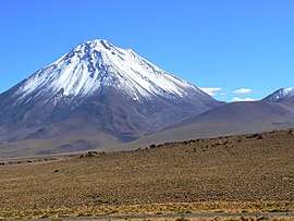
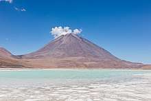
Licancabur (Spanish pronunciation: [likaŋkaˈbuɾ]) is a stratovolcano on the border between Bolivia and Chile, south of the Sairecabur volcano and west of Juriques. Part of the Andean Central Volcanic Zone, it has a prominent, 5,916-metre (19,409 ft)-high cone. A 400-metre (1,300 ft) summit crater containing Licancabur Lake, a crater lake which is among the highest lakes in the world, caps the volcano. Three stages of lava flow emanate from the volcano, which formed on Pleistocene ignimbrites.
| Licancabur | |
|---|---|
 | |
| Highest point | |
| Elevation | 5,916 m (19,409 ft) [1] |
| Prominence | 1,320 metres (4,330 ft) |
| Coordinates | 22°50′2″S 67°53′1″W |
| Geography | |
 Licancabur Location of Licancabur | |
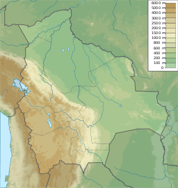
| Location | Chile / Bolivia |
| Parent range | Andes |
| Geology | |
| Age of rock | Holocene |
| Mountain type | Stratovolcano |
| Last eruption | Unknown |
| Climbing | |
| First ascent | Inca, pre-Columbian |
| Easiest route | Hike |
Licancabur has been active during the Holocene, after the ice ages. Although no historic eruptions of the volcano are known, lava flows extending into Laguna Verde have been dated to 13,240 ± 100 BP. The volcano has primarily erupted andesite, with small amounts of dacite and basaltic andesite.
Its climate is cold, dry and very sunny, with high levels of ultraviolet radiation.[2] Licancabur is not covered by glaciers, and vegetation such as cushion plants and shrubs are found lower on its slopes. Chinchillas were formerly hunted on the volcano.
Licancabur is considered a holy mountain by the Atacameno people, related to the Cerro Quimal hill in northern Chile. Archeological sites have been found on its slopes and in the summit crater, which was possibly a prehistoric watchtower.
Name
"Licancabur" derives from the Kunza words used by the Atacameño people to refer to the volcano: lican ("people", or pueblo) and cábur ("mountain"); thus, "mountain of the people".[3] It is also known as "Volcan de Atacama" and "Licancaur".[4]
Geography and geology
General setting
The Andean Volcanic Belt consists of three main volcanic zones: the Northern Volcanic Zone (from 2° N to 5° S), the Central Volcanic Zone (16° to 28° S) and the Southern Volcanic Zone (33° to 46° S). Active volcanism occurs where the Nazca Plate subducts beneath the South American Plate. The plates are separated by shallower subduction zones, with no present-day volcanism.[5] These shallower zones have been attributed to the high speed of the plate collision, the young age of the subducting oceanic lithosphere and the curvature of the subducting plate. The most plausible theory is that variations in buoyancy of a subducting plate creates a flat subduction zone.[6] The Cocos, Juan Fernandez and Nazca Ridges are associated with such volcanic gaps where they collide with the oceanic trench.[7] The subduction of spreading ridges can also diminish volcanism, as observed in the Chile Rise further south. The buoyancy of these crustal structures may hinder subduction, reducing water supply to the mantle[8] and inducing the formation of melts.[9]
Not all volcanism in Chile is relative to subduction of the Nazca Plate; the Chile Ridge exhibits submarine volcanism,[10] and volcanism in the Austral Volcanic Zone is triggered by the Antarctic Plate subducting beneath the South American Plate.[11] One hundred ninety-eight South American volcanoes are on the Global Volcanism Program's Holocene volcano list.[12]
Local setting
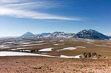
Licancabur is part of the Central Volcanic Zone at the western edge of the Altiplano.[13] Among the region's active volcanoes are Putana (erupted at the end of the 19th century), Llullaillaco (1868) and Lascar (1993).[lower-alpha 1][15] Other stratovolcanoes are Tacora, Nevados de Payachata, Isluga, Tata Sabaya, Ollague, Tocorpuri, Sairecabur and Socompa.[16] The Central Volcanic Zone has more than 1,100 volcanic centres—many older than the Pleistocene, since the area's prevailing arid climate prevented substantial erosion.[10] During the Miocene, the area around Licancabur became the site of major ignimbrite-forming eruptions.[17] Llano de Chajnantor (southeast of Licancabur) is the site of several observatories, including the Llano de Chajnantor Observatory.[18]
The volcano is just south of Sairecabur, a group of volcanoes which rises to 5,800 metres (19,000 ft) and is an apparent source of recent volcanic activity. East of Licancabur is its companion volcano, Juriques.[19] This 5,710-metre (18,730 ft)-high volcano has a large—1.5 kilometres (0.93 mi)[1]—deep crater and is considered a parasitic cone.[15] West-east alignments of volcanoes like Licancabur and Juriques are common in the region, due to tectonic influences.[20] Araral, Cerro Cabana, Cerro Canapa, Cerros de Tocorpuri, Cerro Linzor, Inacaliri, Inca, Jardin, Putana, Volcan Tatio and Zapaleri are other volcanoes in the neighbourhood of Licancabur.[21] One hundred and ninety kilometres (120 miles) southeast, the volcanic chain continues with Tocol, the Purico Complex and the 6,723-metre (22,057 ft)-high Llullaillaco. Volcanoes in the Puna de Atacama formed during the Pliocene on Tertiary dacite, liparite and rhyolite ignimbrites. These rocks have a light colour, due to the rhyolite.[19] Licancabur was formed over 1.35-million-year-old Purico,[22] La Pacana and Chaxas ignimbrite.[13] The Chaxas ignimbrite erupted 1.09 ± 0.56 million years ago.[23]
Licancabur is a 5,916-metre (19,409 ft)-high[1] symmetrical cone.[18] The cone, rising 1,500 metres (4,900 ft) above the surrounding terrain, has a base diameter of 9 cubic kilometres (2.2 cu mi) and a total volume of 35 cubic kilometres (8.4 cu mi).[22] The top of the mountain is a 400-metre (1,300 ft)-wide crater, and its slopes have an approximately 30° gradient.[1] The volcano has erupted blocky lava flows, with thicknesses ranging from 50 to 10 metres (164 to 33 ft); younger lava flows are thinner.[24] Young lava flows on the western sides of the volcano are 6 kilometres (3.7 mi) long; older flows extend 15 kilometres (9.3 mi).[1] Some old lava flows reach Laguna Verde,[13] and 12-kilometre (7.5 mi)-long pyroclastic flow deposits have been found.[1] The volcano's eastern and western flanks look different, since it formed on a basement which dips towards the Salar de Atacama. West of Licancabur are deposits stemming from debris avalanche activity,[22] including blocks 10 metres (33 ft) wide.[24] The border between Bolivia and Chile, defined by the Treaty of Peace and Friendship (1904), crosses the volcano.[25]
.jpg)
An elliptical lake was identified in the Licancabur crater 90 metres (300 ft) beneath the crater rim, with a length of 85 metres (280 ft) and a depth of 1.5–3.0 metres (5–10 ft).[26][27] Fed by snowfall,[28] it is one of the highest lakes in the world.[1] Based on its relative lack of salt deposits, in 1955 researchers postulated that the lake spilled through a 9.1-metre (30 ft) notch in the crater's southwestern rim when the climate was wetter. Excess water now leaves through seepage, keeping salt levels low.[29] There are other lakes (usually frozen) at similar altitudes in the Andes.[28]
The slopes of Licancabur are unstable and prone to rock falls. Some of the instability may be due to earthquakes, snow, wind[15] or geothermal effects (resulting in thermal stress),[28] and it frustrated a 1920s attempt by a Chuquicamata engineer to climb the mountain.[30]
Composition
Licancabur has erupted primarily andesite, but basaltic andesite and dacite have also been found.[31] The rocks are dark and grey-coloured.[32] Basaltic andesite was found in the older lavas, and dacite in the more-recent ones.[33] Although the rocks have a seriate texture,[34] the groundmass is hyalopilitic.[31] Phenocrysts include amphibole, clinopyroxene,[34] hornblende,[31] orthopyroxene, plagioclase and titanomagnetite;[34] olivine is found in andesite,[31] and biotite in dacites.[35] Plagioclase is the most common.[22] The amount of phenocrysts in Licancabur's rocks is smaller than that in other Central Volcanic Zone volcanoes, such as Lascar.[34]
Clots of crystals with diameters of 2–3 millimetres (0.079–0.118 in) or larger have also been found. They contain glass, microliths and phenocrysts, and have a composition similar to phenocrysts.[36] The clots probably formed from the aggregation of phenocrysts and their subsequent growth; some phenocrysts in the rocks formed when the clots broke apart.[37]
The temperature of Licancabur's pre-eruption magma determined the composition of the rocks; it ranges from 930 ± 20 °C (1,706 ± 36 °F) for dacite to 860 to 1,060 ± 20 °C (1,580 to 1,940 ± 36 °F) for andesite. Isotope ratios are typical of Central Volcanic Zone volcanoes. There are differences in the elemental composition of andesites and dacites,[35] with the latter resembling adakites more than the former. Antisana (in the Northern Volcanic Zone) and El Negrillar (in the Central Volcanic Zone) are two other centres which have erupted adakites or adakite-like lavas.[38]
Based on its composition, it is assumed that the magma at Licancabur formed from the partial melting of the oceanic crust subducted at the Peru-Chile Trench after metamorphosis. This magma melted part of the mantle wedge above the subducting plate, mixing with the melt products. Further contamination by crustal Tonalite-Trondhjemite-Granodiorite-like rocks from the Archean, crystal fractionation and magma mixing further up in the crust then yielded the Licancabur magmas.[39] The younger lavas may have formed from the mixing of dacite with the magmas forming the older lavas.[33] Some inclusions in Licancabur rocks seem to be from wall rocks of the magma chamber.[40]
Xenoliths containing gabbro are also found.[34] Unlike neighbouring volcanoes, such as Saciel at Sairecabur (further north) and Tocol (further south), there appear to be no sulfur deposits on Licancabur.[41]
Climate and ecosystem

The region's climate has been dry since the Tertiary.[17] The area around Licancabur is dominated by year-round high pressure caused by the South Pacific High, giving it a very sunny climate. Because of the lack of moisture, solar radiation energy is dissipated primarily by wind.[42] In the Llano de Chajnantor area, wind generally reaches its maximum strength during the day. Its prevailing direction is from the west, except in summer when winds are more variable.[43] Because of the area's tropical location (where the ozone layer is thinner) and high altitude, it receives a large amount of ultraviolet radiation. The world's highest level of ultraviolet radiation was reported from Licancabur, although the high irradiation might have caused measurement artifacts.[44]
Air temperatures obtained at the lake in Licancabur's crater range from 5 to −40 °C (41 to −40 °F).[45] According to observers in 1955, temperatures at the Licancabur summit were always below freezing, sometimes falling below −18 °C (0 °F).[28] At Llano de Chajnantor, southeast of Licancabur, weather records indicate that maximum temperatures range from −15 to 15 °C (5 to 59 °F).[43]
Average precipitation on Licancabur is estimated at about 360 millimetres (14 in) per year,[46] but snowfall probably exceeded 4,300 millimetres (14 ft) in 1955.[29] Snow has been recorded at Llano de Chajnantor when easterly winds transport moisture from the Amazon to the area in summer.[43] Licancabur has no persistent snowpack; snow deposited by storms usually disappears within a few days.[41] In sheltered areas, however, it can persist for months.[43] Licancabur's present snow line is estimated at 6,190 metres (20,310 ft).[47]
Vegetation at lower altitudes is typical of a high tropical desert climate. Three biozones have been described in the region: an Andean zone from 3,850 to 4,200 metres (12,630 to 13,780 ft), with cushion plants and tussock grass; a Puna zone from 3,100 to 3,800 metres (10,200 to 12,500 ft), and a pre-Puna zone from 2,700 to 3,100 metres (8,900 to 10,200 ft) with thorny shrubs. In oases and river valleys of the depression between the pre-Cordillera and the Andes, shrubs such as Atriplex grow; however, the surrounding Atacama Desert is mainly devoid of plant life.[49]
Meltwater from snow supports more life, at higher altitudes, on Licancabur than on similar mountains. Grasses, tola bushes, butterflies, flies and lizards are found as high as 4,900 metres (16,000 ft). Life further down the mountain could be supported by the fertilizing effect of dust from volcanic rocks.[25] Polylepis incana might have been more prevalent at Licancabur during wetter times, and is now more common in Bolivia.[50] Chinchillas were found as high as 4,900 metres (16,000 ft) in 1955. The upper parts of the mountain had been avoided by hunters, and after some high-altitude attempts during the 1920s chinchilla hunting disappeared from the area.[51] Licancabur is part of the Eduardo Avaroa Andean Fauna National Reserve.[52]
Eruptive history
Licancabur formed in three units, all of which have lava flows; the last one also includes pyroclastic deposits. The bulk of the cone was formed by the second unit.[13] The second unit's eruption was preceded by the injection of basic magma into the magma chamber.[53] The oldest flows crop out on the western and northern sides of the volcano and are partially covered by more-recent flows from Licancabur and flows from Sairecabur.[22] Flows from both appear to be pre-glacial.[24] The older lavas have compositions similar to shoshonite and old Sairecabur lavas, and tend to be more basic than recent lavas.[33] Weak explosive activity left pyroclastic deposits on the volcano.[24] Licancabur formed primarily after the late glacial period, between 12,000 and 10,000 years ago.[13] Flank lava flows are its youngest feature. The neighbouring Juriques dates to the Pleistocene.[1]
Licancabur's lava flows were not affected by glaciation, and some have levees and ridges.[22] Lava flows reaching Laguna Verde have been radiocarbon dated to 13,240 ± 100 BP,[26] and 13,270 ± 100 years old lacustrine sediments have been buried by Licancabur flows.[54] The volcano has not erupted during recorded history,[19] but bubbling and water temperatures of 14 °C (57 °F) have been observed in the crater lake of Licancabur,[55] which may remain liquid due to geothermal heating.[28]
Human settlement

Despite being lower than many neighbouring mountains, Licancabur stands out from other volcanoes in the region and is well-known.[56] The Atacameno people worshiped it,[41] and other high mountains are still considered sacred. Licancabur was considered divine, and attempts to climb it were discouraged and sometimes met by force; climbing it supposedly brought misfortune.[57] It is said that Licancabur would punish people who climbed it,[58] and the volcano is the mate of Quimal in the Cordillera Domeyko; at the solstices, the mountains overshadow one another.[59] According to local myth, this copulation fertilizes the earth.[60] Another legend mentions that a legless Inka king lived on Licancabur's summit; he was carried around in a litter and sometimes the carriers died from exhaustion and were buried with treasures.[61] Finally, there is a story about Inkas hiding gold and silver in the crater lake; the wares disappeared and supposedly turned the lake bitter and emerald-green.[62] Licancabur is considered "male"[63] and a mountain of fire, in contrast to San Pedro (considered a mountain of water).[64] The 1953 Antofagasta earthquake was considered divine retribution for an attempt to climb the mountain that year.[65] According to legend, a golden object (most commonly a guanaco) was offered as tribute in the summit crater;[57] human sacrifices have been reported on the volcano.[66] Between 1,500 and 1,000 years ago, people were buried in San Pedro de Atacama in a posture facing the volcano[67] and the Pukará de Quitor fortress in Chile is also oriented towards the mountain.[68]
In 1953, climbers found three buildings open on one side on Licancabur. They were built in the pirca style, where stones are fitted together without mortar.[27] A woodpile was found between two of the buildings,[69] which were described as two dwellings and a fireplace.[58] Wood was also scattered around its crater.[27] With the summit's panoramic view, which includes Calama and pass routes from Argentina, Licancabur may have been a watchtower for the Atacamenos.[70] Its watchtower function may have been coordinated with fortresses in the area such as Lasana, Turi[71] and a settlement identified in 1955 at Quebrada de Chaxas (northwest of the volcano).[50] The settlement at Licancabur had a central courtyard, surrounded by buildings, and ceramics found there resemble these of Pukará de Quitor and Toconao Oriente.[58] A tambo reportedly existed at the volcano.[72]
Other archeological findings on Andean mountains were made on Acamarachi and Pular (where ceremonial platforms were found), Cerro Colorado, Juriques, Llullaillaco, Miniques and Quimal. Sites had pirca structures and firewood, and some may have been part of a signaling system.[73] Many were in use during the Inca civilization, and on Quimal artifacts and reports of use during the Spanish Empire have been found.[74] Aconcagua, Coropuna, Chachani, El Plomo, El Toro, Llullaillaco, Mercedario and Picchu Picchu are other mountains with Inca sanctuaries.[75]
The area around Licancabur was first settled by the Atacameno people, presumably because of the water in local canyons. The Incas, under Yawar Waqaq, were followed by the Spanish during the early 16th century in the region; both were looking for yareta and chinchillas.[41]
Unlike neighbouring mountains, Licancabur is difficult to climb; its upper part slopes steeply, and the ground is loose and prone to landslides.[76] Ascent from the Bolivian side takes six hours plus half that time for the descent and requires caution during winter, although the mountain can be climbed during any month.[62] Rumours about a "staircase", later probably obliterated by landslides and rockfalls, were reported in 1955.[50] In 1953, a road climbed to 4,300 metres (14,000 ft).[57] The first recorded ascent of the volcano was in 1884 by Severo Titicocha, who was accompanied by Juan Santelices (a delegate of the Chilean government) in an 1886 ascent.[77]
See also
- List of volcanoes in Bolivia
- List of volcanoes in Chile
- List of andean peaks with known pre-columbian ascents
- Sairecabur
- Purico Complex
Notes
- As of March 2016, the last eruption occurred in October 2015.[14]
References
- "Licancabur". Global Volcanism Program. Smithsonian Institution.
- Cabrol, N. A.; Feister, U; Häder, D-P; Piazena, H; Grin, EA; Klein, A (2014). "Record solar UV irradiance in the tropical Andes". Frontiers in Environmental Science. 2 (19): 6. doi:10.3389/fenvs.2014.00019.
- Rudolph 1955, pp. 153–154.
- "Licancabur". Global Volcanism Program. Smithsonian Institution., Synonyms & Subfeatures
- Wörner, G.; Harmon, R. S.; Davidson, J.; Moorbath, S.; Turner, D. L.; McMillan, N.; Nyes, C.; Lopez-Escobar, L.; Moreno, H. (September 1988). "The Nevados de Payachata volcanic region (18°S/69°W, N. Chile)" (PDF). Bulletin of Volcanology. 50 (5): 287–289. Bibcode:1988BVol...50..287W. doi:10.1007/BF01073587. hdl:2027.42/47805.
- Gutscher, Marc-André (April 2002). "Andean subduction styles and their effect on thermal structure and interplate coupling". Journal of South American Earth Sciences. 15 (1): 6–7. Bibcode:2002JSAES..15....3G. doi:10.1016/S0895-9811(02)00002-0.
- Nur & Ben-Avraham 1981, p. 730.
- Nur & Ben-Avraham 1981, p. 734.
- Nur & Ben-Avraham 1981, p. 738.
- Teresa Moreno (Ph. D.); Wes Gibbons (2007). The Geology of Chile. Geological Society of London. p. 147. ISBN 978-1-86239-220-5.
- Stern, C. R.; Kilian, Rolf (1996). "Role of the subducted slab, mantle wedge and continental crust in the generation of adakites from the Andean Austral Volcanic Zone". Contributions to Mineralogy and Petrology. 123 (3): 264. Bibcode:1996CoMP..123..263S. doi:10.1007/s004100050155. ISSN 0010-7999.
- "The South America Region". Global Volcanism Program. Smithsonian Institution. Archived from the original on 22 September 2016.
- Figueroa, Déruelle & Demaiffe 2009, p. 311.
- "Lascar". Global Volcanism Program. Smithsonian Institution. Archived from the original on 4 March 2016. Retrieved 19 November 2016.
- Rudolph 1955, p. 161.
- H Leyrit; C Montenat (8 August 2000). Volcaniclastic Rocks, from Magmas to Sediments. CRC Press. p. 5. ISBN 978-90-5699-278-1.
- de Silva 1989, p. 94.
- Giovanelli et al. 2001, p. 791.
- Rudolph 1955, p. 160.
- Klaus-Joachim Reutter; Ekkehard Scheuber; Peter Wigger (6 December 2012). Tectonics of the Southern Central Andes: Structure and Evolution of an Active Continental Margin. Springer Science & Business Media. p. 109. ISBN 978-3-642-77353-2.
- Rudolph 1951, p. 112.
- Figueroa & Déruelle 1996, p. 563.
- de Silva 1989, p. 102.
- Figueroa 1997, p. 322.
- Rudolph 1955, p. 170.
- Cabrol, Grin & Hock 2007, p. 4.
- Rudolph 1955, p. 156.
- Rudolph 1955, p. 162.
- Rudolph 1955, p. 164.
- Rudolph 1951, p. 113.
- Figueroa & Deruelle 1999, p. 240.
- Figueroa 1997, p. 324.
- Figueroa & Déruelle 1996, p. 566.
- Figueroa, Déruelle & Demaiffe 2009, p. 312.
- Figueroa, Déruelle & Demaiffe 2009, p. 313.
- Figueroa & Deruelle 1999, p. 241.
- Figueroa & Deruelle 1999, p. 243.
- Figueroa, Déruelle & Demaiffe 2009, p. 314.
- Figueroa, Déruelle & Demaiffe 2009, p. 317.
- Figueroa 1997, p. 326.
- Rudolph 1955, p. 153.
- Giovanelli et al. 2001, p. 792.
- Giovanelli et al. 2001, p. 793.
- Albarracín, Virginia Helena; Gärtner, Wolfgang; Farias, María Eugenia (January 2016). "Forged Under the Sun: Life and Art of Extremophiles from Andean Lakes". Photochemistry and Photobiology. 92 (1): 14–28. doi:10.1111/php.12555. PMID 26647770.
- Cabrol, Grin & Hock 2007, p. 5.
- Sepúlveda Rivera, Isabel; Molina Otárola, Raúl; Delgado-Serrano, María del Mar; Guerrero Ginel, José Emilio (December 2015). "Aguas, Riego y Cultivos: Cambios y Permanencias en los Ayllues de San Pedro de Atacama". Estudios Atacameños (in Spanish) (51): 189. doi:10.4067/S0718-10432015000200012.
- Ram Bali Singh (1992). Dynamics of Mountain Geosystems. APH Publishing. p. 165. ISBN 978-81-7024-472-1.
- Cavieres, Lohengrin A.; Arroyo, Mary T.K.; Posadas, Paula; Marticorena, Clodomiro; Matthei, Oscar; Rodríguez, Roberto; Squeo, Francisco A.; Arancio, Gina (2002). "Identification of priority areas for conservation in an arid zone: application of parsimony analysis of endemicity in the vascular flora of the Antofagasta region, northern Chile". Biodiversity and Conservation. 11 (7): 1303. doi:10.1023/A:1016001714358.
- Rudolph 1955, p. 171.
- Rudolph 1955, p. 169.
- Villarroel, Javier A. Velasco; Peñaranda, Edgar S. (2000-01-01). "Generación de energía eléctrica a partir de vapor del pozo geotérmico apacheta AP-XI". Revista Metalúrgica UTO (in Spanish): 49.
- Figueroa 1997, p. 325.
- Cabrol et al. 2018, p. 163.
- Cabrol et al. 2018, p. 158.
- Rudolph 1955, p. 151.
- Rudolph 1955, p. 154.
- Le Paige 1978, p. 37.
- Le Paige 1978, p. 40.
- Contreras, Ernesto (1994-01-01). "Cultura y naturaleza en la cuenca del Salar de Atacama". Estudios Atacameños. Arqueología y Antropología Surandinas (in Spanish). 0 (11): 183. ISSN 0718-1043.
- Nielsen, Axel E.; Angiorama, Carlos I.; Ávila, Florencia (2017). "Ritual as Interaction with Non-Humans". Ritual as Interaction with Non-Humans:: Prehispanic Mountain Pass Shrines in the Southern Andes. Rituals of the Past. University Press of Colorado. p. 252. ISBN 9781607325956. JSTOR j.ctt1mtz7j7.15.
- "Atractivos turísticos". Servicio Nacional de Áreas Protegidas (in Spanish). Retrieved 31 October 2018.
- Moraga, Anita Carrasco (November 2010). "A Sacred Mountain and the Art of "Impression Management"". Mountain Research and Development. 30 (4): 394. doi:10.1659/MRD-JOURNAL-D-09-00065.1.
- Castro, Victoria; Aldunate, Carlos (February 2003). "Sacred Mountains in the Highlands of the South-Central Andes". Mountain Research and Development. 23 (1): 73. doi:10.1659/0276-4741(2003)023[0073:SMITHO]2.0.CO;2.
- Rudolph 1955, p. 156,159.
- Bouysse-Cassagne, Thérèse; Chacama R, Juan (2012). "Partición Colonial del Territorio, Cultos Funerarios y Memoria Ancestral en Carangas y Precordillera de Arica (Siglos Xvi-Xvii)". Chungará (Arica) (in Spanish). 44 (4): 669–689. doi:10.4067/S0717-73562012000400009.
- Knudson, Kelly J. (2007). "La influencia de Tiwanaku en San Pedro de Atacama: Una investigación utilizando el análisis de isótopos del estroncio". Estudios Atacameños (33): 7–24. doi:10.4067/S0718-10432007000100002. ISSN 0718-1043.
- Sims, Alberto Muñoz; Arredondo, Marta Pérez (12 July 2017). "Training experience for tour guides in San Pedro de Atacama (Chile); based on bio-psycho-sociospiritual model". International Journal of Scientific Management and Tourism. 3 (2): 374.
- Rudolph 1955, p. 157.
- Rudolph 1955, pp. 165–166.
- Rudolph 1955, p. 167.
- Uribe Rodríguez, Mauricio (July 2004). "El Inka y el Poder Como Problemas de la Arqueología del Norte Grande de Chile". Chungará (Arica) (in Spanish). 36 (2). doi:10.4067/S0717-73562004000200006.
- Le Paige 1978, pp. 40–41.
- Le Paige 1978, pp. 47–48.
- Moyano, Ricardo (2009). "El adoratorio del cerro El Potro: Arqueología de alta montaña en la cordillera de Copiapó, norte de Chile". Estudios Atacameños (in Spanish) (38): 39–54. doi:10.4067/S0718-10432009000200004.
- Rudolph 1955, p. 152.
- Rudolph 1955, p. 159.
Sources
- Cabrol, Nathalie A.; Grin, Edmond A.; Hock, Andrew N. (2007-01-01). Hoover, Richard B; Levin, Gilbert V; Rozanov, Alexei Y; Davies, Paul C. W (eds.). "Mitigation of environmental extremes as a possible indicator of extended habitat sustainability for lakes on early Mars". Instruments, Methods, and Missions for Astrobiology X. 6694: 669410. Bibcode:2007SPIE.6694E..10C. doi:10.1117/12.731506.CS1 maint: ref=harv (link)
- Cabrol, Nathalie A.; Grin, Edmond A.; Zippi, Pierre; Noffke, Nora; Winter, Diane (2018-01-01), Cabrol, Nathalie A.; Grin, Edmond A. (eds.), "Chapter 6 - Evolution of Altiplanic Lakes at the Pleistocene/Holocene Transition: A Window Into Early Mars Declining Habitability, Changing Habitats, and Biosignatures", From Habitability to Life on Mars, Elsevier, pp. 153–177, Bibcode:2018fhlm.book..153C, ISBN 9780128099353, retrieved 2019-09-02CS1 maint: ref=harv (link)
- Figueroa, O.A.; Déruelle, B. (1996-01-01). Licancabur, an andesitic volcano of the South-central Andes. Colloques et Séminaires. ORSTOM. pp. 563–566. ISBN 9782709913324.CS1 maint: ref=harv (link)
- Figueroa, Oscar (October 1997). "El volcán Licancabur −22o56'S, 67o53'W, segunda región de Antofagasta-: Geología, petrografía y mineralogía" (PDF). biblioteca.sernageomin.cl (in Spanish). Antofagasta: 8th Chilean Geological Congress. Retrieved 17 November 2016.CS1 maint: ref=harv (link)
- Figueroa, Oscar; Deruelle, Bernard (October 1999). "ORIGIN OF CRYSTAL CLOTS AND THEIR ORTHOPYROXENE- TITANOMAGNETITE SYMPLECTITES IN LAVAS FROM THE LICANCABUR VOLCANO, SOUTH-CENTRAL ANDES" (PDF). Fourth ISAG: 240–244. Retrieved 17 November 2016.CS1 maint: ref=harv (link)
- Figueroa, Oscar; Déruelle, Bernard; Demaiffe, Daniel (April 2009). "Genesis of adakite-like lavas of Licancabur volcano (Chile—Bolivia, Central Andes)". Comptes Rendus Geoscience. 341 (4): 310–318. Bibcode:2009CRGeo.341..310F. doi:10.1016/j.crte.2008.11.008.CS1 maint: ref=harv (link)
- Giovanelli, Riccardo; Darling, Jeremy; Sarazin, Marc; Yu, Jennifer; Harvey, Paul; Henderson, Charles; William Hoffman; Keller, Luke; Barry, Don (2001-01-01). "The Optical/Infrared Astronomical Quality of High Atacama Sites. I. Preliminary Results of Optical Seeing". Publications of the Astronomical Society of the Pacific. 113 (785): 789. arXiv:astro-ph/0103345. Bibcode:2001PASP..113..789G. doi:10.1086/322135. ISSN 1538-3873.CS1 maint: ref=harv (link)
- Le Paige, Gustavo (1978-01-01). "Vestigios arqueológicos incaicos en las cumbres de la zona atacameña". Estudios Atacameños (in Spanish) (6): 36–52. doi:10.22199/S07181043.1978.0006.00005.CS1 maint: ref=harv (link)
- Nur, Amos; Ben-Avraham, Zvi (January 1981). "Volcanic gaps and the consumption of aseismic ridges in South America". Nazca Plate: Crustal Formation and Andean Convergence. Geological Society of America Memoirs. 154. pp. 729–740. doi:10.1130/mem154-p729. ISBN 978-0-8137-1154-6.CS1 maint: ref=harv (link)
- Rudolph, William E. (January 1951). "Chuquicamata Twenty Years Later". Geographical Review. 41 (1): 88–113. doi:10.2307/211310. JSTOR 211310.CS1 maint: ref=harv (link)
- Rudolph, William E. (April 1955). "Licancabur: Mountain of the Atacamenos". Geographical Review. 45 (2): 151–171. doi:10.2307/212227. JSTOR 212227.CS1 maint: ref=harv (link)
- de Silva, S.L. (May 1989). "Geochronology and stratigraphy of the ignimbrites from the 21°30′S to 23°30′S portion of the Central Andes of northern Chile". Journal of Volcanology and Geothermal Research. 37 (2): 93–131. Bibcode:1989JVGR...37...93D. doi:10.1016/0377-0273(89)90065-6.CS1 maint: ref=harv (link)
General sources
- Biggar, John (2005). Andes: a Guide for Climbers (3rd ed.). Castle Douglas: Andes. pp. 284–285. ISBN 978-0-9536087-2-0.
- De Silva, Shanaka L.; Francis, Peter (1991). Volcanoes of the Central Andes. Berlin: Springer-Verlag. pp. 81–82. ISBN 978-3-540-53706-9.
- NASA Licancabur Expedition: Exploring the Highest Lakes on Earth
- Gonzalez-Ferran, Oscar (1994). Volcanes de Chile (in Spanish) (1 ed.). Santiago, Chile: Instituto geografico militar. ISBN 978-956-202-054-1.
External links
| Wikimedia Commons has media related to Licancabur. |
- Licancabur, tour 2003
- Lake Licancabur
- Licancabur, cerca de Marte – Mercuria Calama article – (In Spanish).
| Authority control |
|---|