Volcanic Explosivity Index
The Volcanic Explosivity Index (VEI) is a relative measure of the explosiveness of volcanic eruptions. It was devised by Chris Newhall of the United States Geological Survey and Stephen Self at the University of Hawaii in 1982.
Volume of products, eruption cloud height, and qualitative observations (using terms ranging from "gentle" to "mega-colossal") are used to determine the explosivity value. The scale is open-ended with the largest volcanoes in history given magnitude 8. A value of 0 is given for non-explosive eruptions, defined as less than 10,000 m3 (350,000 cu ft) of tephra ejected; and 8 representing a mega-colossal explosive eruption that can eject 1.0×10¹² m3 (240 cubic miles) of tephra and have a cloud column height of over 20 km (66,000 ft). The scale is logarithmic, with each interval on the scale representing a tenfold increase in observed ejecta criteria, with the exception of between VEI-0, VEI-1 and VEI-2.[1]
Classification
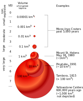
With indices running from 0 to 8, the VEI associated with an eruption is dependent on how much volcanic material is thrown out, to what height, and how long the eruption lasts. The scale is logarithmic from VEI-2 and up; an increase of 1 index indicates an eruption that is 10 times as powerful. As such there is a discontinuity in the definition of the VEI between indices 1 and 2. The lower border of the volume of ejecta jumps by a factor of one hundred, from 10,000 to 1,000,000 m3 (350,000 to 35,310,000 cu ft), while the factor is ten between all higher indices. In the following table, the frequency of each VEI indicates the approximate frequency of new eruptions of that VEI or higher.
| VEI | Ejecta volume (bulk) |
Classification | Description | Plume | Frequency | Tropospheric injection |
Stratospheric injection[2] | ||||||||||||||||||||||||||||||||||||||||||||||||||||||||||||||||||||||
|---|---|---|---|---|---|---|---|---|---|---|---|---|---|---|---|---|---|---|---|---|---|---|---|---|---|---|---|---|---|---|---|---|---|---|---|---|---|---|---|---|---|---|---|---|---|---|---|---|---|---|---|---|---|---|---|---|---|---|---|---|---|---|---|---|---|---|---|---|---|---|---|---|---|---|---|---|---|
| Examples | |||||||||||||||||||||||||||||||||||||||||||||||||||||||||||||||||||||||||||||
| 0 | < 104 m3 | Hawaiian | Effusive | < 100 m | continuous | negligible | none | ||||||||||||||||||||||||||||||||||||||||||||||||||||||||||||||||||||||
| Hoodoo Mountain (c. 7050 BC),[3] Erebus (1963), Kīlauea (1977), Socorro Island (1993), Mawson Peak (2006), Dallol (2011), Piton de la Fournaise (2017) | |||||||||||||||||||||||||||||||||||||||||||||||||||||||||||||||||||||||||||||
| 1 | > 104 m3 | Hawaiian / Strombolian | Gentle | 100 m – 1 km | daily | minor | none | ||||||||||||||||||||||||||||||||||||||||||||||||||||||||||||||||||||||
| Stromboli (since Roman times), Nyiragongo (2002), Raoul Island (2006) | |||||||||||||||||||||||||||||||||||||||||||||||||||||||||||||||||||||||||||||
| 2 | > 106 m3 | Strombolian / Vulcanian | Explosive | 1–5 km | every two weeks | moderate | none | ||||||||||||||||||||||||||||||||||||||||||||||||||||||||||||||||||||||
| Unzen (1792), Cumbre Vieja (1949), Galeras (1993), Sinabung (2010), Whakaari (2019) | |||||||||||||||||||||||||||||||||||||||||||||||||||||||||||||||||||||||||||||
| 3 | > 107 m3 | Vulcanian / Peléan / Sub-Plinian | Catastrophic | 3–15 km | 3 months | substantial | possible | ||||||||||||||||||||||||||||||||||||||||||||||||||||||||||||||||||||||
| Lassen Peak (1915), Nevado del Ruiz (1985), Soufrière Hills (1995), Ontake (2014), Anak Krakatoa (2018) | |||||||||||||||||||||||||||||||||||||||||||||||||||||||||||||||||||||||||||||
| 4 | > 0.1 km3 | Peléan / Plinian/Sub-Plinian | Cataclysmic | > 10 km (Plinian or sub-Plinian) | 18 months | substantial | definite | ||||||||||||||||||||||||||||||||||||||||||||||||||||||||||||||||||||||
| Taal Volcano (1749) and (2020), Laki (1783), Kīlauea (1790), Mayon (1814), Pelée (1902), Colima (1913), Sakurajima (1914), Katla (1918), Galunggung (1982), Eyjafjallajökull (2010), Nabro (2011), Calbuco (2015) | |||||||||||||||||||||||||||||||||||||||||||||||||||||||||||||||||||||||||||||
| 5 | > 1 km3 | Peléan/Plinian | Paroxysmic | > 10 km (Plinian) | 12 years | substantial | significant | ||||||||||||||||||||||||||||||||||||||||||||||||||||||||||||||||||||||
| Vesuvius (79), Fuji (1707), Tarawera (1886), Agung (1963), St. Helens (1980), El Chichón (1982), Hudson (1991), Puyehue (2011) | |||||||||||||||||||||||||||||||||||||||||||||||||||||||||||||||||||||||||||||
| 6 | > 10 km3 | Plinian / Ultra-Plinian | Colossal | > 20 km | 50–100 yrs | substantial | substantial | ||||||||||||||||||||||||||||||||||||||||||||||||||||||||||||||||||||||
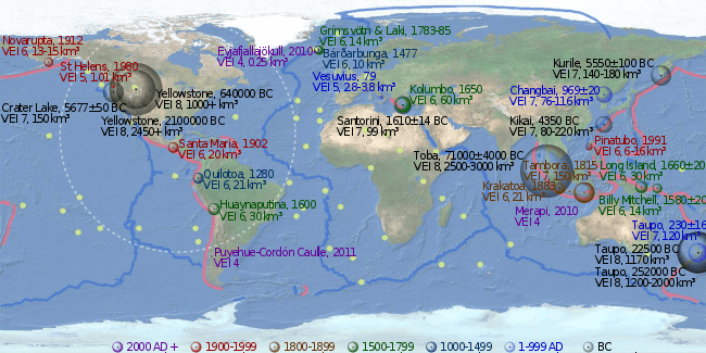
| Lake Laach Volcano (c. 10,950 BC), Nevado de Toluca (8,550 BC), Veniaminof (c. 1750 BC), Lake Ilopango (450), Ceboruco (930), Huaynaputina (1600), Krakatoa (1883), Santa Maria (1902), Novarupta (1912), Pinatubo (1991) | |||||||||||||||||||||||||||||||||||||||||||||||||||||||||||||||||||||||||||||
| 7 | > 100 km3 | Ultra-Plinian | Super-colossal | > 20 km | 500–1,000 yrs | substantial | substantial | ||||||||||||||||||||||||||||||||||||||||||||||||||||||||||||||||||||||
| Valles Caldera (1,264,000 BC), Phlegraean Fields (37,000 BC), Aira Caldera (22,000 BC), Mount Mazama (c. 5,700 BC), Kikai Caldera (4,300 BC), Cerro Blanco (c. 2300 BC), Thera (c. 1620 BC), Taupo (180), Baekdu (946), Samalas (1257), Tambora (1815) | |||||||||||||||||||||||||||||||||||||||||||||||||||||||||||||||||||||||||||||
| 8 | > 1000 km3 | Ultra-Plinian | Mega-colossal | > 20 km | > 50,000 yrs[4][5] | vast | vast | ||||||||||||||||||||||||||||||||||||||||||||||||||||||||||||||||||||||
| La Garita (26,300,000 BC), Cerro Galán (2,200,000 BC), Huckleberry Ridge Tuff (2,100,000 BC), Yellowstone (630,000 BC), Whakamaru (in TVZ) (254,000 BC),[6] Toba (74,000 BC), Taupo (25,360 BC) | |||||||||||||||||||||||||||||||||||||||||||||||||||||||||||||||||||||||||||||
About 40 eruptions of VEI-8 magnitude within the last 132 million years (Mya) have been identified, of which 30 occurred in the past 36 million years. Considering the estimated frequency is on the order of once in 50,000 years,[4] there are likely many such eruptions in the last 132 Mya that are not yet known. Based on incomplete statistics, other authors assume that at least 60 VEI-8 eruptions have been identified.[7][8] The most recent is Lake Taupo's Oruanui eruption, more than 27,000 years ago, which means that there have not been any Holocene eruptions with a VEI of 8.[9]
There have been at least 10 eruptions of VEI-7 in the last 10,000 years. There are also 58 plinian eruptions, and 13 caldera-forming eruptions, of large, but unknown magnitudes. By 2010, the Global Volcanism Program of the Smithsonian Institution had catalogued the assignment of a VEI for 7,742 volcanic eruptions that occurred during the Holocene (the last 11,700 years) which account for about 75% of the total known eruptions during the Holocene. Of these 7,742 eruptions, about 49% have a VEI of ≤ 2, and 90% have a VEI ≤ 3.[10]
Limitations
Under the VEI, ash, lava, lava bombs, and ignimbrite are all treated alike. Density and vesicularity (gas bubbling) of the volcanic products in question is not taken into account. In contrast, the DRE (dense-rock equivalent) is sometimes calculated to give the actual amount of magma erupted. Another weakness of the VEI is that it does not take into account the power output of an eruption, which makes the VEI extremely difficult to determine with prehistoric or unobserved eruptions.
Although VEI is quite suitable for classifying the explosive magnitude of eruptions, the index is not as significant as sulphur dioxide emissions in quantifying their atmospheric and climatic impact, as a 2004 paper by Georgina Miles, Roy Grainger and Eleanor Highwood points out.
"Tephra, or fallout sediment analysis, can provide an estimate of the explosiveness of a known eruption event. It is, however, not obviously related to the amount of SO2 emitted by the eruption. The Volcanic Explosivity Index (VEI) was derived to catalogue the explosive magnitude of historical eruptions, based on the order of magnitude of erupted mass, and gives a general indication as to the height the eruptive column reached. The VEI itself is inadequate for describing the atmospheric effects of volcanic eruptions. This is clearly demonstrated by two eruptions, Agung (1963) and El Chichón (1982). Their VEI classification separates them by an order of magnitude in explosivity, although the volume of SO2 released into the stratosphere by each was measured to be broadly similar, as shown by the optical depth data for the two eruptions."[11]
Lists of large eruptions
- Timeline of volcanism on Earth (mostly VEI-6, within 2 kya)
- List of large volcanic eruptions of the 19th century (≥ VEI-4)
- List of large volcanic eruptions of the 20th century (≥ VEI-4)
- List of large volcanic eruptions in the 21st century (≥ VEI-4)
- List of large volcanic eruptions (mostly VEI-6–8, within 50 Mya)
- List of largest volcanic eruptions (VEI-7–8, mostly within 500 Mya)
See also
- Supervolcano
- Lists of volcanoes
- List of natural disasters by death toll
- List of volcanic eruptions by death toll
- Dispersal index
References
- Newhall, Christopher G.; Self, Stephen (1982). "The Volcanic Explosivity Index (VEI): An Estimate of Explosive Magnitude for Historical Volcanism" (PDF). Journal of Geophysical Research. 87 (C2): 1231–1238. Bibcode:1982JGR....87.1231N. doi:10.1029/JC087iC02p01231. Archived from the original (PDF) on December 13, 2013.
- "Volcanic Explosivity Index (VEI)". Global Volcanism Program. Smithsonian National Museum of Natural History. Archived from the original on November 10, 2011. Retrieved August 21, 2014.
- "Global Volcanism Program - Hoodoo Mountain". volcano.si.edu.
- Dosseto, A. (2011). Turner, S. P.; Van-Orman, J. A. (eds.). Timescales of Magmatic Processes: From Core to Atmosphere. Wiley-Blackwell. ISBN 978-1-4443-3260-5.
- Rothery, David A. (2010), Volcanoes, Earthquakes and Tsunamis, Teach Yourself
- Froggatt, P. C.; Nelson, C. S.; Carter, L.; Griggs, G.; Black, K. P. (13 February 1986). "An exceptionally large late Quaternary eruption from New Zealand". Nature. 319 (6054): 578–582. Bibcode:1986Natur.319..578F. doi:10.1038/319578a0.
- BG, Mason (2004). "The size and frequency of the largest explosive eruptions on Earth". Bull Volcanol. 66 (8): 735–748. Bibcode:2004BVol...66..735M. doi:10.1007/s00445-004-0355-9.
- Bryan, S.E. (2010). "The largest volcanic eruptions on Earth" (PDF). Earth-Science Reviews. 102 (3–4): 207–229. Bibcode:2010ESRv..102..207B. doi:10.1016/j.earscirev.2010.07.001.
- Mason, Ben G.; Pyle, David M.; Oppenheimer, Clive (2004). "The size and frequency of the largest explosive eruptions on Earth". Bulletin of Volcanology. 66 (8): 735–748. Bibcode:2004BVol...66..735M. doi:10.1007/s00445-004-0355-9.
- Siebert, L.; Simkin, T.; Kimberly, P. (2010). Volcanoes of the World (3rd ed.). University of California Press. pp. 28–38. ISBN 978-0-520-26877-7.
- Miles, M. G.; Grainger, R. G.; Highwood, E. J. (2004). "Volcanic Aerosols: The significance of volcanic eruption strength and frequency for climate" (PDF). Quarterly Journal of the Royal Meteorological Society. 130 (602): 2361–2376. doi:10.1256/qj.03.60.
External links
- VEI glossary entry from a USGS website
- How to measure the size of a volcanic eruption, from The Guardian
- The size and frequency of the largest explosive eruptions on Earth, a 2004 article from the Bulletin of Volcanology
- List of Large Holocene Eruptions (VEI > 4) from the Smithsonian Global Volcanism Program