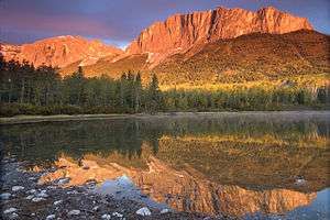
Mount John Laurie
Mount John Laurie is a mountain in the Canadian Rockies, located in the province of Alberta.
| Mount John Laurie | |
|---|---|
| Mount Yamnuska | |
 Yamnuska | |
| Highest point | |
| Elevation | 2,240 m (7,350 ft) [1] |
| Listing | Mountains of Alberta |
| Coordinates | 51°07′27″N 115°07′06″W [2] |
| Geography | |
 Mount John Laurie Alberta, Canada | |
| Parent range | Canadian Rockies |
| Topo map | NTS 82O/03 |
| Geology | |
| Age of rock | Paleozoic |
| Mountain type | Limestone and shale |
| Climbing | |
| First ascent | Unknown |
| Easiest route | Scramble[1] |
Various names
Officially named Mount John Laurie in 1961,[3] it is also known as Mount Laurie, or by the Nakoda name Mount Yamnuska, or simply Yamnuska.[3] Yamnuska translates to "wall of stone"[4] and is derived from the Stoney Nakoda word Iyamnathka that describes steep cliffs or "the flat faced mountain."
John Lee Laurie, 1899–1959, was a founder of the Indian Association of Alberta. The mountain's 1961 renaming came at the request of the Stoney Nakoda First Nation. Laurie, an educator and political activist, served as secretary of the Indian Association of Alberta from 1944 to 1956, promoting the causes of Alberta native peoples.[5]
Peak and climbing
Standing at approximately 2,240 m (7,350 ft) above sea level,[6] Mount John Laurie is the last mountain on the north side of the Bow River valley (Bow Valley) as it exits the mountains for the foothills and prairie of Alberta. Located close to Calgary, it is a popular "great scramble". It is also a popular rock climbing destination, with over 100 routes of all difficulty levels spread out across its face.
Geology
Mount John Laurie is the result of the McConnell Thrust Fault, which put the resistive, cliff forming Cambrian carbonate rock of the Eldon Formation on top of the much younger and weaker Cretaceous aged, clastic Belly River Formation[7][8] The fault, which sits at the base of the cliff face, represents an age difference of around 450 million years.[7]
Access
At the Highway 1X and Highway 1A (Bow Valley Trail) intersection, travel east for two kilometres (1.2 mi). Turn into the signed parking lot that says "Yamnuska."[6]
References
- Kane, Alan (1999). "Traverse of Mount Yamnuska". Scrambles in the Canadian Rockies. Calgary: Rocky Mountain Books. pp. 68–69. ISBN 0-921102-67-4.
- "Mount Laurie (Îyâmnathka)". Geographical Names Data Base. Natural Resources Canada. Retrieved 2019-06-14.
- "Yamnuska". PeakFinder.com. Retrieved 2014-03-25.
- Boles, Glen W.; Laurilla, Roger W.; Putnam, William L. (2006). Canadian Mountain Place Names. Vancouver: Rocky Mountain Books. pp. 275. ISBN 978-1-894765-79-4.
- "John Lee Laurie". Society of Alberta archives. Retrieved 2014-03-19.
- "Traverse of Mount Yamnuska - Scramble". Outdoor Escapade. Retrieved 2014-03-19.
- McMechan, M.E., 1995, Geology, Rocky Mountain Foothills and Front Ranges in Kananaskis Country, Alberta. Geological Survey of Canada. Map 1865A, scale 1:100 000.
- Vrolijk, P.; van der Pluijm, B.A. (1999). "Clay gouge". Journal of Structural Geology. 21: 1039–1048. doi:10.1016/S0191-8141(99)00103-0.
External links
| Wikimedia Commons has media related to Mount John Laurie. |