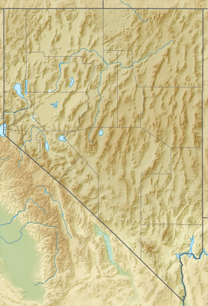
Mount Charleston
Mount Charleston, including Charleston Peak (Nuvagantu, literally "where snow sits", in Southern Paiute[5]) at 11,916 feet (3,632 m),[6] is the highest mountain in both the Spring Mountains and Clark County, in Nevada, United States. It is the eighth-highest mountain in the state.[7] Well separated from higher peaks by large, low basins, Charleston Peak is the most topographically prominent peak in Nevada,[8] and the eighth-most-prominent peak in the contiguous United States.[9] It is one of eight ultra-prominent peaks in Nevada. It is located about 35 miles (56 km) northwest of Las Vegas within the Mount Charleston Wilderness, which is within the Spring Mountains National Recreation Area of the Humboldt–Toiyabe National Forest.
- Not to be confused with: Town of Mount Charleston, Nevada.
| Mount Charleston | |
|---|---|
 Mount Charleston, with Trout Canyon in the foreground, Charleston peak at left rear | |
| Highest point | |
| Elevation | 11,916 ft (3,632 m) [1] |
| Prominence | 8,241 ft (2,512 m) |
| Parent peak | Mount Jefferson[1] |
| Listing |
|
| Coordinates | 36°16′18″N 115°41′44″W [4] |
| Geography | |
 Mount Charleston Location in Nevada | |
| Location | Clark County, Nevada, U.S. |
| Parent range | Spring Mountains |
| Topo map | USGS Charleston Peak |
| Climbing | |
| Easiest route | Trail hike, class 1 |
Overview
Mount Charleston is a year-round getaway for Las Vegas's residents and visitors, with a number of hiking trails and a modest ski area. The mountain, which is snow-capped more than half the year, can be seen from parts of the Las Vegas Strip when looking toward the west. Mount Charleston has nearly 200 camp sites and over 150 picnic areas, some of which are RV-accessible.
The village of Mount Charleston, Nevada, lies at its base to the east.
The state of Nevada issues license plates with the caption "Mt. Charleston" and an image of the peak in the background. Sales of the plate supports the natural environment of the Mount Charleston area through grants administered by the Nevada Division of State Lands.[10]
According to the Federal Writers' Project, Mount Charleston was named for Charleston, South Carolina by southern sympathizers.[11]
Plane crash
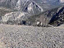
Near its summit are the remnants of a 1955 plane crash. A CIA C-54 Military Air Transport Service plane crashed near the peak on November 17, 1955 during a blizzard.[12] The plane was on route from Burbank (location of Lockheed’s Skunkworks), to Groom Lake (or Watertown Strip as it was also known in those days) to work on the secret U-2 plane development.[13] Fourteen men (a mix of military staffers and civilian subcontractors, engineers, and technicians) were on board when it crashed, all of whom perished. There are still remains from the plane that can be hiked to just off the main southern loop trail to the peak.[14]
A memorial featuring a propeller from the downed aircraft (which was recovered decades after the crash from the crash site) was installed at the Spring Mountains Visitor Gateway[15] in 2015. It was Nevada's first national memorial and the first on U.S. Forest Service land.[16]
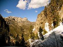
Hiking

Charleston Peak is a popular destination for hikers.[17] The summit offers panoramic views from the Sierra Nevada, Death Valley, and Las Vegas. There are two well-marked and well-maintained trails to the summit: South Loop Trail [18][19] and North Loop Trail.[20] The trails can be done on their own as an out-and-back hike, or combined as a loop. Both approaches involve a strenuous 16-mile+ round trip with over 4000 feet of climbing. The hike often takes all day. The hike is most accessible in the snow-free months of summer and fall.
References
- "Charleston Peak, Nevada". Peakbagger.com. Retrieved 2008-04-02.
- "Desert Peaks Section List" (PDF). Angeles Chapter, Sierra Club. Retrieved 2016-08-08.
- "Great Basin Peaks List". Toiyabe Chapter, Sierra Club. Retrieved 2016-08-08.
- "Charleston". NGS data sheet. U.S. National Geodetic Survey. Retrieved 2008-04-02.
- Stoffle, RW; Halmo, DB; Austin, DE (1997). "Cultural Landscapes and Traditional Cultural Properties: A Southern Paiute View of the Grand Canyon and Colorado River". American Indian Quarterly. 21 (2): 229–249. doi:10.2307/1185646. JSTOR 1185646.
- "Charleston Peak". Geographic Names Information System. United States Geological Survey. Retrieved 2011-05-18.
- "Nevada 11,000-foot Peaks". Peakbagger.com. Retrieved 2014-10-22.
- "Nevada Peaks with 2000 feet of Prominence". Peakbagger.com. Retrieved 2014-10-23.
- "USA Lower 48 Top 100 Peaks by Prominence". Peakbagger.com. Retrieved 2011-03-09.,
- "Nevada Charitable and Collegiate License Plates". Nevada Department of Motor Vehicles. Retrieved 2008-11-08.
- Federal Writers' Project (1941). Origin of Place Names: Nevada (PDF). W.P.A. p. 14.
- Johnson, Erica D. (October 10, 2002). "Silent heroes: As Cold War secrets emerge, infamous 1955 Mount Charleston crash remembered - Las Vegas Sun Newspaper". lasvegassun.com.
- "The Accident - Silent Heroes".
- "Charleston Peak South Trail". AllTrails.com.
- "Spring Mountains Visitor Gateway". Go Mt. Charleston. Retrieved 2018-12-28.
- "Families commemorate memorial to 14 men killed in 1955 plane crash". May 30, 2015.
- "Charleston Peak : Climbing, Hiking & Mountaineering : SummitPost". www.summitpost.org. Retrieved 2018-12-28.
- "Mt Charleston Peak Hike - South Loop Trail (2019)". HikingGuy.com. December 27, 2018.
- "Charleston Peak via South Loop". June 10, 2013.
- "North Loop/Trail Canyon". Summitpost.
External links
| Wikimedia Commons has media related to Charleston Peak. |
- "Charleston Peak". SummitPost.org.