Verdun-sur-le-Doubs
Verdun-sur-le-Doubs is a commune in the Saône-et-Loire department in the region of Bourgogne in eastern France.
Verdun-sur-le-Doubs | |
|---|---|
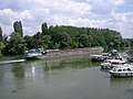
 A general view of Verdun-sur-le-Doubs | |
.svg.png) Coat of arms | |
Location of Verdun-sur-le-Doubs 
| |
 Verdun-sur-le-Doubs  Verdun-sur-le-Doubs | |
| Coordinates: 46°53′49″N 5°01′27″E | |
| Country | France |
| Region | Bourgogne-Franche-Comté |
| Department | Saône-et-Loire |
| Arrondissement | Chalon-sur-Saône |
| Canton | Gergy |
| Intercommunality | Trois Rivières du Verdunois |
| Area 1 | 7.27 km2 (2.81 sq mi) |
| Population (2017-01-01)[1] | 1,083 |
| • Density | 150/km2 (390/sq mi) |
| Time zone | UTC+01:00 (CET) |
| • Summer (DST) | UTC+02:00 (CEST) |
| INSEE/Postal code | 71566 /71350 |
| Elevation | 173–180 m (568–591 ft) (avg. 180 m or 590 ft) |
| 1 French Land Register data, which excludes lakes, ponds, glaciers > 1 km2 (0.386 sq mi or 247 acres) and river estuaries. | |
It is located in Bourgogne-Franche-Comté at the confluence of the Doubs and the Saône in the Bresse plain, near Beaune and Chalon-sur-Saône.
It is a very old settlement and played the role of fortified place at the French kingdom frontier during several centuries.
Today Verdun-sur-le-Doubs is an agricultural and tourist center well known for fishing, river boating and good eating. The pôchouse is the local dish with different types of river fishes cooked with dry Burgundy white wine ("Bourgogne aligoté") and cream.
In the Second World War Verdun-sur-le-Doubs was situated on the Demarcation Line. In 1995 sixteen communes, followed shortly by four others, were united to form the Community of Communes of the Trois Rivieres (CC3R).[2]
References
- "Populations légales 2017". INSEE. Retrieved 6 January 2020.
- Some dates that have marked Verdun sur le Doubs"Archived copy". Archived from the original on October 23, 2014. Retrieved October 15, 2014.CS1 maint: archived copy as title (link)
External links
| Wikimedia Commons has media related to Verdun-sur-le-Doubs. |


| Authority control |
|---|