Semur-en-Brionnais
Semur-en-Brionnais is a commune in the Saône-et-Loire department in the region of Bourgogne-Franche-Comté in eastern France.
Semur-en-Brionnais | |
|---|---|
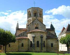 Saint-Hilaire Church | |
 Coat of arms | |
Location of Semur-en-Brionnais 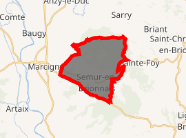
| |
 Semur-en-Brionnais  Semur-en-Brionnais | |
| Coordinates: 46°15′49″N 4°05′30″E | |
| Country | France |
| Region | Bourgogne-Franche-Comté |
| Department | Saône-et-Loire |
| Arrondissement | Charolles |
| Canton | Chauffailles |
| Government | |
| • Mayor (2014-2020) | François Baciak |
| Area 1 | 15.56 km2 (6.01 sq mi) |
| Population (2017-01-01)[1] | 623 |
| • Density | 40/km2 (100/sq mi) |
| Time zone | UTC+01:00 (CET) |
| • Summer (DST) | UTC+02:00 (CEST) |
| INSEE/Postal code | 71510 /71110 |
| Elevation | 271–464 m (889–1,522 ft) (avg. 396 m or 1,299 ft) |
| 1 French Land Register data, which excludes lakes, ponds, glaciers > 1 km2 (0.386 sq mi or 247 acres) and river estuaries. | |
Sights
- The oldest castle in Burgundy, Château Saint Hugues, dating from 9th century.
- The collegiale Saint Hilaire, the village church, dating from the 12th century.
- The chapel of St Martin la Vallée
- The Priory St Hugues, now the Convent of the Sisters of the Order of St. John
- The Chapter House. Built as a small monastery, this building later housed the village school and now contains, among other things, an exhibition of Romanesque Architecture in the Brionnais
- The village ramparts
Semur-en-Brionnais is the birthplace of
- Saint Hugues, the founder of Cluny Abbey, born 1024
- Henriette d'Angeville, the second woman to climb Mont Blanc.
- The chef Albert Roux OBE, KFO, born in October 1935. He owns Le Gavroche, the first restaurant in Britain to win three Michelin Stars.
References
- "Populations légales 2017". INSEE. Retrieved 6 January 2020.
- "Medieval villages in Burgundy France, Semur-en-Brionnais". burgundytoday.com. Retrieved 2008-10-11.
External links
| Wikimedia Commons has media related to Semur-en-Brionnais. |
| Authority control |
|
|---|
This article is issued from Wikipedia. The text is licensed under Creative Commons - Attribution - Sharealike. Additional terms may apply for the media files.