Le Puley
Le Puley is a commune in the Saône-et-Loire department in the region of Bourgogne in eastern France.
Le Puley | |
|---|---|
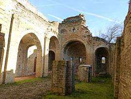 The Priory | |
_en_Saone_et_Loire.svg.png) Coat of arms | |
Location of Le Puley 
| |
 Le Puley  Le Puley | |
| Coordinates: 46°40′45″N 4°33′52″E | |
| Country | France |
| Region | Bourgogne-Franche-Comté |
| Department | Saône-et-Loire |
| Arrondissement | Chalon-sur-Saône |
| Canton | Blanzy |
| Area 1 | 5.3 km2 (2.0 sq mi) |
| Population (2017-01-01)[1] | 97 |
| • Density | 18/km2 (47/sq mi) |
| Time zone | UTC+01:00 (CET) |
| • Summer (DST) | UTC+02:00 (CEST) |
| INSEE/Postal code | 71363 /71460 |
| Elevation | 249–421 m (817–1,381 ft) (avg. 260 m or 850 ft) |
| 1 French Land Register data, which excludes lakes, ponds, glaciers > 1 km2 (0.386 sq mi or 247 acres) and river estuaries. | |
Geography
The main roads are connecting the village to Germagny and Genouilly to the south and Saint-Micaud to the north.
Main sights
The romanesque priory "Saint Christophe" (12th century), protected in 1973 by the French National Heritage as a Monument historique.[2] The belltower collapsed on the building in 1877, causing major damages.
See also
- Guillaume des Autels who used to own a château named "des Hôtels" in le Puley.
- Communes of the Saône-et-Loire department
References
- "Populations légales 2017". INSEE. Retrieved 6 January 2020.
- "Monument historique registration number PA00113395" (in French). culture.gouv.fr. Retrieved 3 January 2013.
| Wikimedia Commons has media related to Le Puley. |
| Authority control |
|
|---|
This article is issued from Wikipedia. The text is licensed under Creative Commons - Attribution - Sharealike. Additional terms may apply for the media files.