Vahanga
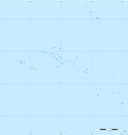
Vahanga is a small uninhabited atoll part of the Acteon Group in the Tuamotu archipelago, French Polynesia and belongs to the municipality of the Gambier Islands.
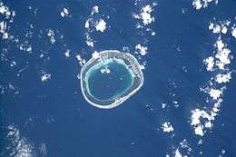 NASA picture of Vahanga Atoll | |
 Vahanga | |
| Geography | |
|---|---|
| Location | Pacific Ocean |
| Coordinates | 21°19′S 136°39′W |
| Archipelago | Tuamotus |
| Area | 12.6 km2 (4.9 sq mi) (lagoon) 3.8 km2 (1.5 sq mi) (above water) |
| Width | 3.6 km (2.24 mi) |
| Administration | |
France | |
| Overseas collectivity | French Polynesia |
| Administrative subdivision | Tuamotus |
| Commune | Gambier Islands |
| Demographics | |
| Population | Uninhabited[1] (2012) |
Geography
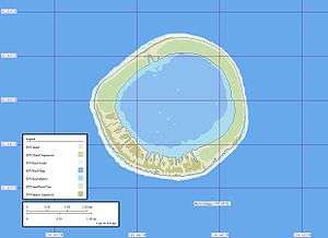
Vahanga is located 9 km west of Tenarunga and 1362 km southeast of Tahiti . It is a circular atoll with a diameter of 3.6 km and an area of 3.8 km2 (12.6 km2 lagoon inclusive). It is a low atoll with a landing place on the northwest side of the island near a white house, but there is no access to the lagoon.
History
The first recorded sighting of this atoll was made during the Spanish expedition of the Portuguese navigator Pedro Fernández de Quirós on 5 February 1606 under the name Las Cuatro Coronadas (the "four crowned" (by coconut palms)),[2][3] however these observations were not fully documented. As such, the first unambiguous approach to the island was made in 1833 by navigator Thomas Ebrill on his merchant vessel Amphitrite and again in 1837 by Lord Edward Russell, commander of the H.M.S Actaeon, the name given to the group.[4] It was previously owned by a man named Captain Nicholas but was redeemed in 1934.[5]
Flora and fauna
Vahanga hosts a flora composed of coconut trees, Portulaca lutea,[6] Cassytha filiformis,[7] and Amaranthaceae such as the species Achyranthes aspera var. velutina.[8]
In 2007, an ecological project conducted by the University of Auckland and the Ornithological Society of Polynesia aimed to eradicate Vahanga's Polynesian rats, which had colonized the atoll, to restore balance to the ecosystem supporting bird species such as the Polynesian ground-dove and the Tuamotu sandpiper.[9] A previous campaign in 2000 had failed in this goal.
See also
- Matureivavao
- Tenararo
- Tenarunga
- Acteon Group
- Desert island
- List of islands
References
- "Population". Institut de la statistique de la Polynésie française. Retrieved 22 September 2014.
- Brand, Donald D. The Pacific Basin: A History of its Geographical Explorations The American Geographical Society, New York, 1967, p.136.
- Kelly, Celsus, O.F.M. La Austrialia del Espiritu Santo. The Journal of Fray Martín de Munilla O.F.M. and other documents relating to the Voyage of Pedro Fernández de Quirós to the South Sea (1605-1606) and the Franciscan Missionary Plan (1617-1627) Cambridge, 1966, p.39,62.
- Pacific Island: Eastern-Pacific - Geographical handbook series, James Wightman Davidson and Naval Intelligence Division, editions Naval Intelligence Division, 1945, p.224.
- Archaeology of Mangareva and neighboring atolls by Kenneth Pike Emory, editions Kraus, 1971, p.58-60.
- Flora of French Polynesia by Jacques Florence, editions IRD, 2004, p.344
- Flora of French Polynesia by Jacques Florence, editions IRD, 2004, p.145
- Flora of French Polynesia by Jacques Florence, editions IRD, 2004, p.50
- CEPF SMALL GRANT FINAL PROJECT COMPLETION REPORT
- Sailing Directions, Pub 126, "Pacific Islands" NIMA 2002; page 12
External links
Tuamotus Gambiers | Islands/Atolls | ||
|---|---|---|---|
| Island groups | |||