Anaa
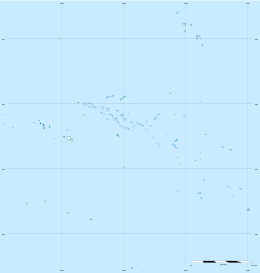
Anaa, Nganaa-nui (or Ara-ura)[2] is an atoll in the Tuamotu archipelago, in French Polynesia. It is located in the north-west of the archipelago, 350 km to the east of Tahiti. It is oval in shape, 29.5 km in length and 6.5 km wide, with a total land area of 38 km² and a population of 504. The atoll is made up by eleven small barren islands with deeper and more fertile soil than other atolls in the Tuamotus. The lagoon is shallow, without entrance, and formed by three main basins. Although it does not have any navigable access, the water of the lagoon renews by several small channels that can be crossed walking.
 NASA picture of Anaa Atoll | |
 Anaa | |
| Geography | |
|---|---|
| Location | Pacific Ocean |
| Coordinates | 17°20′31″S 145°30′31″W |
| Archipelago | Tuamotus |
| Area | 90 km2 (35 sq mi) (lagoon) 38 km2 (15 sq mi) (above water) |
| Length | 29.5 km (18.33 mi) |
| Width | 6.5 km (4.04 mi) |
| Highest elevation | 11 m (36 ft) |
| Highest point | (unnamed) |
| Administration | |
France | |
| Overseas collectivity | French Polynesia |
| Administrative subdivision | Îles Tuamotu-Gambier |
| Commune | Anaa |
| Largest settlement | Tuuhora |
| Demographics | |
| Population | 494[1] (2016) |
| Pop. density | 13/km2 (34/sq mi) |
History
The atoll of Anaa was known by the legendary cruelty of its soldiers who in the seventeenth century, dominated the north-west of the Tuamotus.
The Spanish expedition of Pedro Fernández de Quirós landed on Anaa on 10 February 1606 and named it Conversión de San Pablo.[3] Its sight was recorded by French explorer Louis Antoine de Bougainville in 1768.[4] James Cook sighted it in 1769. Because of its shape, he called it Chain Island. Later, Anaa was visited by Spanish explorer Domingo de Boenechea,[5] on November 1 of 1772, who called it Isla de Todos los Santos (All Saints Island) because they arrived on All Saints' Day.
At the beginning of the nineteenth century, control of the atoll went to the Pomaré of Tahiti. Around 1850 Anaa was an active center of the nacre commerce and copra, with a maximum population of 2,000. The missionary competition between Mormons of North America and French Catholics led to a revolt in 1852, and an intervention by French colonial troops.
In 1878 and 1906 Anaa suffered severe hurricane damages and was completely flooded. After the hurricane of 1983, the only village was moved and reconstructed, incorporating a refuge shelter with capacity for all its population.
Anaa has a territorial airport which was inaugurated in 1976.
Tuuhora
The main village is Tuuhora, also called Tukuhora or Anaa, with a population of about 350. The other small villages like Temarie, Otepipi, Mania and Tematahoa have small seasonal population. The population subsists mainly on fishing, the cultivation of nacre and the production of copra.
Commune of Anaa
Anaa | |
|---|---|
 Location of Anaa in the Tuamotu Archipelago | |
Location of Anaa 
| |
| Coordinates: 17°20′31″S 145°30′31″W | |
| Country | France |
| Overseas collectivity | French Polynesia |
| Subdivision | Îles Tuamotu-Gambier |
| Area 1 | 55.7 km2 (21.5 sq mi) |
| Population (2017) | 811 |
| • Density | 15/km2 (38/sq mi) |
| Time zone | UTC−10:00 |
| INSEE/Postal code | 98711 / |
| 1 French Land Register data, which excludes lakes, ponds, glaciers > 1 km2 (0.386 sq mi or 247 acres) and river estuaries. | |
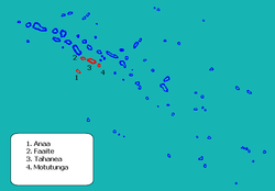
The atoll Anaa is part of the commune (municipality) Anaa, that is part of the administrative subdivision of the Îles Tuamotu-Gambier.[6] This commune also includes the associated atoll of Faaite and the uninhabited atolls of Tahanea and Motutunga.[7] The seat of the commune is the village Tuuhora.[7]
Overview
| Atoll | main village | Population 2017[8] | land area (km²)[9] | lagoon (km²) | Location |
|---|---|---|---|---|---|
| commune associée of Anaa | |||||
| Anaa | Tuuhora | 494 | 37.7 | 90 | 17°20′S 145°30′W |
| commune associée of Faaite | |||||
| Faaite | Hitianau | 317 | 18.0 | 227 | 16°43′S 145°19′W |
| Motutunga | - | - | 126 | 17°04′S 144°17′W | |
| Tahanea | - | - | 522.5 | 16°50′S 144°45′W | |
| commune of Anaa | Tukuhora | 811 | 55.7 | 965.5 | |
Faaite
Faaite is an atoll located 60 km to the north of Anaa. The total surface of the atoll is of 230 km². Its dry land area has a surface of 9 km². The inner lagoon has a navigable channel to the ocean. The main village is Hitianau, with a total population of 246. It was discovered by John Turnbull in 1802, the first retailer of the Pacific who used the route of Tahiti to Hawaii. Historically the atoll also has been known as Miloradovich.
Tahanea
Tahanea is an atoll of 63 km², with three passages towards the interior of the lagoon. It is uninhabited and is visited occasionally. It was discovered by Domingo Bonaechea in 1772, who called it San Julian. It has also been known as Tchitschagof.
Motutunga
Motutunga is an uninhabited atoll, with a passage to the interior of the nonnavigable lagoon. Domingo Bonaechea called it San Blas. It has also been known as Adventure Island.
References
- "Population". Institut de la statistique de la Polynésie française. Retrieved 23 September 2014.
- Young, J.L. (1899). "Names of the Paumotu Islands, with the old names so far as they are known". Journal of the Polynesian Society. 8 (4): 264–268. Archived from the original on 10 February 2012. Retrieved 7 January 2015.
- Langdon, Robert The Lost Caravel Sidney, 1975, p.47.
- Tahiti et ses archipels par Pierre-Yves Toullelan, éditions Karthala, 1991, ISBN 2-86537-291-X, p.61.
- Salmond, Anne (2010). Aphrodite's Island. Berkeley: University of California Press. pp. 241. ISBN 9780520261143.
- Décret n° 2005-1611 du 20 décembre 2005 pris pour l'application du statut d'autonomie de la Polynésie française, Légifrance
- Décret n°72-407 du 17 mai 1972 portant création de communes dans le territoire de la Polynésie française, Légifrance
- Répartition de la population en Polynésie française en 2017, Institut de la statistique de la Polynésie française
- "R1- Population sans doubles comptes, des subdivisions, communes et communes associées de Polynésie française, de 1971 à 1996". Institut de la statistique de la Polynésie française. Retrieved 2019-03-14.
External links
| Wikimedia Commons has media related to Anaa. |
Tuamotus Gambiers | Islands/Atolls | ||
|---|---|---|---|
| Island groups | |||
| Authority control |
|
|---|