Tematagi
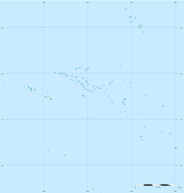
Tematagi or Tematangi[2] is an atoll in the southeastern area of the Tuamotu Archipelago, French Polynesia. Tematagi's nearest neighbour is Mururoa, which is located 161 kilometres (100 miles) to the ESE.
 NASA picture of Tematagi Atoll | |
 Tematagi | |
| Geography | |
|---|---|
| Location | Pacific Ocean |
| Coordinates | 21°40′S 140°37′W |
| Archipelago | Tuamotus |
| Area | 61 km2 (24 sq mi) (lagoon) 7.7 km2 (3.0 sq mi) (above water) |
| Length | 11.5 km (7.15 mi) |
| Width | 7 km (4.3 mi) |
| Administration | |
France | |
| Overseas collectivity | French Polynesia |
| Administrative subdivision | Tuamotus |
| Commune | Tureia |
| Demographics | |
| Population | 58[1] (2012) |
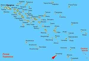
Tematagi is a medium-sized atoll. It measures approximately 11.5 kilometres (7.1 miles) in length and has a maximum width of 7 kilometres (4.3 miles) with a land area of almost 8 square kilometres (3.1 square miles). As its reef completely encloses the deep lagoon, which is 61 square kilometres (24 square miles), there is no navigable pass to enter the lagoon.
There are many relatively large islands on Tematagi's reef, as well as a few small motu. The main village is Tuihana. There were 58 inhabitants on Tematagi in the last census.
History
The first recorded European to visit this atoll was Captain William Bligh on the ship Providence on April 5, 1792. At the time of Bligh's visit, it was uninhabited. Tematagi Atoll appears in some maps as "Bligh's Lagoon Island".
When Frederick Beechey visited Tematagi in 1826 he found inhabitants there. In 1857, the captain of the Julia, coasting along Tematagi Atoll saw armed natives follow the course of his schooner... "clad in many-coloured stuffs".
Population
In 1966, Catholic missionary Father Victor Valleys mentioned in a letter to his bishop that he had planted 135,000 coconut trees on the islands. Teams of workers from neighboring atolls spent three or four months a year at Tematagi harvesting copra. Legally, the atoll did not belong in the public domain of Polynesia: a document states that "the atoll of Tematagi was granted a final license to SCI Tematagi Vanavana in 1974." This SCI was led by Valleys and ceased operation with his death in 1986.
A pontoon landing was built at the village of Teakoro, along with a church and administrative buildings. The legal status of the population is not clear since the atoll remains the property of SCI, under the guise of a Catholic Mission. Transactions were even made in 1998 between the Vice-President of French Polynesia and Bruno Wan, a pearl prospector. In 2001, the village had 36 residents. The atoll has no airstrip, but, since 2015 there has been a telephone and fax service via satellite.
Antipode of Mecca
Tematagi is the closest land area to the antipode of Mecca. This means that the correct direction of Muslim prayer (qibla) varies widely between Tematagi and its neighboring islands.
Administration
Administratively Tematagi belongs to the commune of Tureia, which includes the atolls of Tureia, Fangataufa, Moruroa, Tematagi and Vanavana.
Images & Maps
 Inhabitants of Tematagi, removed to Tahiti in 1857 for killing and eating the survivors of the shipwrecked schooner Sarah Ann
.jpg) Image Source: Landsat S-07-20_2000 (1:70,000)
Image Source: Landsat S-07-20_2000 (1:70,000).jpg) Map Source: EVS Precision Map (1:70,000)
Map Source: EVS Precision Map (1:70,000)
References
- "Population". Institut de la statistique de la Polynésie française. Retrieved 9 October 2014.
- Board of Geographical Names Site Internet: http://geonames.usgs.gov/foreign/index.html
External links
- Tematangi Atoll FP (EVS Islands)
- Thoughts - Antipode of Qibla at Mecca (EVS Islands)
- Shuttle Image ISS004-E-6727 (Astronaut Photography)
- Shuttle Image ISS009-E-6082 (Astronaut Photography)
- Tematangi Atoll FP (Oceandots.com) at the Wayback Machine (archived December 23, 2010)
- Tuamotu Atolls List (Pacific Image)
Tuamotus Gambiers | Islands/Atolls | ||
|---|---|---|---|
| Island groups | |||