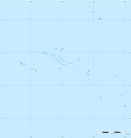
Makemo
Makemo, Rangi-kemo or Te Paritua,[2] is one of the larger of the Tuamotu atolls in French Polynesia.
 NASA picture of Makemo Atoll | |
 Makemo | |
| Geography | |
|---|---|
| Location | Pacific Ocean |
| Coordinates | 16°35′55″S 143°39′41″W |
| Archipelago | Tuamotus |
| Area | 603 km2 (233 sq mi) (lagoon) 56 km2 (22 sq mi) (above water) |
| Length | 69 km (42.9 mi) |
| Width | 16.5 km (10.25 mi) |
| Administration | |
France | |
| Overseas collectivity | French Polynesia |
| Administrative subdivision | Îles Tuamotu-Gambier |
| Commune | Makemo |
| Largest settlement | Pouheva (pop. 600) |
| Demographics | |
| Population | 824[1] (2017) |
Makemo | |
|---|---|
 NASA picture of Makemo Atoll. | |
 | |
Location of Makemo 
| |
| Coordinates: 16°35′55″S 143°39′41″W | |
| Country | France |
| Overseas collectivity | French Polynesia |
| Subdivision | Îles Tuamotu-Gambier |
| Area 1 | 100 km2 (40 sq mi) |
| Population (2017) | 1,508 |
| • Density | 15/km2 (39/sq mi) |
| Time zone | UTC−10:00 |
| INSEE/Postal code | 98726 /98769 |
| 1 French Land Register data, which excludes lakes, ponds, glaciers > 1 km2 (0.386 sq mi or 247 acres) and river estuaries. | |
Makemo Atoll measures 69 km in length and 16.5 km in width, giving it a land area of 56 km². It is the fourth largest atoll of the Tuamotu Archipelago in terms of lagoon surface, with a lagoon of 603 km² in area.[3] Despite its size, Makemo's lagoon has only two navigable passes.
Makemo Atoll has 824 inhabitants;[1] the main village is named Pouheva with a population of 600. The village has a wharf and a boarding school of 150 children from neighbouring islands. It also hosts Makemo Airport, located to the west of Pouheva.
History
Makemo is the home of legendary Polynesian hero Moeava.[4]
The first recorded European to arrive to Makemo Atoll was English pearl merchant John Buyers on the brig Margaret. He arrived at Makemo on 10 March 1803 on the same day he discovered Taenga and named the Makemo Atoll "Phillips Island", after a late sheriff of London, Sir Richard Phillips. In some maps Makemo appears as "Kutusov".
Makemo territorial (domestic) airport was opened in 1976.
Administration
The commune of Makemo consists of the atolls of Makemo, Haraiki, Marutea Nord, Katiu, Tuanake, Hiti, Tepoto Sud, Raroia, Takume, Taenga and Nihiru.[5]
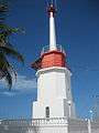 Makemo lighthouse
 Makemo church
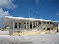 Makemo mayor and police station
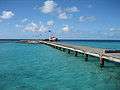 Makemo port
 Flat reef on the east coast of Makemo
References
- Répartition de la population en Polynésie française en 2017, Institut de la statistique de la Polynésie française
- Young, J.L. (1899). "Names of the Paumotu Islands, with the old names so far as they are known". Journal of the Polynesian Society. 8 (4): 264–268. Retrieved 7 January 2015.
- "Tuamotu Archipelago - Makemo". Archived from the original on December 23, 2010. Retrieved 2009-03-14.CS1 maint: BOT: original-url status unknown (link)
- Craig, Robert D. (1989). Dictionary of Polynesian Mythology. ISBN 9780313258909.
- Décret n°72-407 du 17 mai 1972 portant création de communes dans le territoire de la Polynésie française, Légifrance
- History, &
External links
| Wikimedia Commons has media related to Makemo. |
Tuamotus Gambiers | Islands/Atolls | ||
|---|---|---|---|
| Island groups | |||