Arutua
Arutua, or Ngaru-atua[2] is an atoll in the Tuamotu group in French Polynesia. It is located 40 km SW of Rangiroa. The closest land is Apataki Atoll, only 16 km to the East.
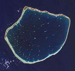 NASA picture of Arutua Atoll | |
 Arutua | |
| Geography | |
|---|---|
| Location | Pacific Ocean |
| Coordinates | 15°14′43″S 146°36′43″W |
| Archipelago | Tuamotus |
| Area | 484 km2 (187 sq mi) (lagoon) 15 km2 (6 sq mi) (above water) |
| Length | 31 km (19.3 mi) |
| Width | 24 km (14.9 mi) |
| Administration | |
France | |
| Overseas collectivity | French Polynesia |
| Administrative subdivision | Îles Tuamotu-Gambier |
| Commune | Arutua |
| Largest settlement | Rautini |
| Demographics | |
| Population | 680[1] (2012) |
Arutua | |
|---|---|
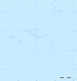
 Location of Arutua in the Tuamotu Archipelago | |
Location of Arutua 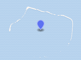
| |
| Coordinates: 15°14′43″S 146°36′44″W | |
| Country | France |
| Overseas collectivity | French Polynesia |
| Subdivision | Îles Tuamotu-Gambier |
| Area 1 | 46.0 km2 (17.8 sq mi) |
| Population (2017) | 1,664 |
| • Density | 36/km2 (94/sq mi) |
| Time zone | UTC−10:00 |
| INSEE/Postal code | 98713 / |
| 1 French Land Register data, which excludes lakes, ponds, glaciers > 1 km2 (0.386 sq mi or 247 acres) and river estuaries. | |
Arutua Atoll has a roughly pentagonal shape. Length 31 km (19 mi) , width 24 km (15 mi) . The lagoon area is 484 km2 (187 sq mi) and the land area is 15 km2 (6 sq mi). Its lagoon is wide and deep with one navigable passage. As of 2012, Arutua had a population of 680 inhabitants. The main village is Rautini. There is a small airport at Arutua which was opened in 1984.
Geographically Arutua belongs to the Palliser Islands (Îles Palliser) subgroup of the Tuamotus.
History
The first recorded European to visit Arutua Atoll was Jakob Roggeveen (who also first sighted Easter Island) in 1722. British mariner Frederick Beechey touched at Arutua in 1826. He named this atoll "Cockburn Island".
Administration
This atoll is part of the commune of Arutua, which consists of Arutua, as well as the atolls of Apataki and Kaukura.[3] The seat of the commune is the village Rautini.[3] The commune is in the administrative subdivision of the Îles Tuamotu-Gambier.[4]
Demographics
| Island | Population (2017 census)[5] | Area (km²)[6] | Area of lagoon (km²) |
|---|---|---|---|
| Apataki | 442 | 20.0 | 706 |
| Arutua | 808 | 15.0 | 484 |
| Kaukura | 414 | 11.0 | 434 |
| TOTAL | 1664 | 46.0 | 1624 |
Table 1. Current population.
| Island | 2007 | 2012 | 2017 |
|---|---|---|---|
| Apataki | 495 | 350 | 442 |
| Arutua | 725 | 680 | 808 |
| Kaukura | 541 | 475 | 414 |
| TOTAL | 1761 | 1505 | 1664 |
Table 2. Population over time.
Images and maps
.jpg) Image Source: Landsat S-06-15_2008
Image Source: Landsat S-06-15_2008.jpg) Map Source: EVS Precision Map (1:170,000)
Map Source: EVS Precision Map (1:170,000)
References
- "Population". Institut de la statistique de la Polynésie française. Retrieved 24 September 2014.
- Young, J.L. (1899). "Names of the Paumotu Islands, with the old names so far as they are known". Journal of the Polynesian Society. 8 (4): 264–268. Archived from the original on 10 February 2012. Retrieved 7 January 2015.
- Décret n°72-407 du 17 mai 1972 portant création de communes dans le territoire de la Polynésie française, Légifrance
- Décret n° 2005-1611 du 20 décembre 2005 pris pour l'application du statut d'autonomie de la Polynésie française, Légifrance
- Répartition de la population en Polynésie française en 2017, Institut de la statistique de la Polynésie française
- "R1- Population sans doubles comptes, des subdivisions, communes et communes associées de Polynésie française, de 1971 à 1996". Institut de la statistique de la Polynésie française. Retrieved 2019-03-14.
External links
| Wikimedia Commons has media related to Arutua. |
- Arutua Atoll FP (EVS Islands)
- Shuttle Image ISS014-E-5393 (Astronaut Photography)
- Arutua Atoll FP (Oceandots.com) at the Wayback Machine (archived December 23, 2010)
- Tuamotu Atolls List (Pacific Image)
Tuamotus Gambiers | Islands/Atolls | ||
|---|---|---|---|
| Island groups | |||