U.S. Route 54 in Missouri
U.S. Route 54 (US 54) in Missouri is a west-east highway that starts from the Kansas state line in Nevada to the Illinois state line in Louisiana.
| ||||
|---|---|---|---|---|
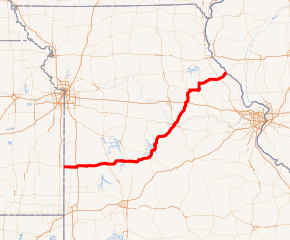
US 54 highlighted in red | ||||
| Route information | ||||
| Maintained by MoDOT | ||||
| Length | 271.508 mi[1] (436.950 km) | |||
| Existed | 1927[2]–present | |||
| Major junctions | ||||
| West end | ||||
| ||||
| East end | ||||
| Location | ||||
| Counties | Vernon, Cedar, St. Clair, Hickory, Camden, Miller, Cole, Callaway, Audrain, Ralls, Pike | |||
| Highway system | ||||
| ||||

Route description

In Missouri, US 54 runs from the southwest portion of the state to the northeast. It is a major conduit through the Ozarks and is the primary access road to Pomme de Terre Lake and Lake of the Ozarks. After entering the state it passes through Nevada, El Dorado Springs, Hermitage, crossing Lake of the Ozarks the first time just north of Ha Ha Tonka State Park. It passes through Camdenton and crosses the lake a second time on the Grand Glaize Bridge at Osage Beach before bypassing Eldon and going through Jefferson City, where it crosses the Missouri River via the Jefferson City Bridge and briefly overlaps US 63. Just north of the bridge, it splits passing through Fulton, crossing I-70 and US 40 at Kingdom City, bypassing Mexico, sharing a concurrency with Route 19 through Laddonia, passing just north of Vandalia, and ultimately crossing the Mississippi River via the Champ Clark Bridge into Illinois at Louisiana.
History
US 54 was originally formed in Missouri after changing from US 26, however the routing went from Cedar County to Polk County, then Dallas County, then into Camden County. In 1932, the highway was rerouted into Saint Clair County and then Hickory County, and paved over.[2]
Junction list
All exits are unnumbered.
| County | Location | mi[1] | km | Destinations | Notes | |||
|---|---|---|---|---|---|---|---|---|
| Vernon | Coal Township | 0.000 | 0.000 | Continuation into Kansas | ||||
| 1.807 | 2.908 | |||||||
| Deerfield | 5.807 | 9.345 | ||||||
| Deerfield Township | 9.805 | 15.780 | ||||||
| Nevada | 14.071 | 22.645 | ||||||
| 14.562 | 23.435 | Western end of Loop 49 overlap | ||||||
| 15.056 | 24.230 | Eastern end of Loop 49 overlap | ||||||
| 15.864– 15.883 | 25.531– 25.561 | I-49 exit 102A | ||||||
| Walker Township | 21.782 | 35.055 | ||||||
| Clear Creek Township | 27.439 | 44.159 | ||||||
| 27.650 | 44.498 | |||||||
| Cedar | Box Township | 31.173 | 50.168 | |||||
| El Dorado Springs | 33.673 | 54.191 | ||||||
| 34.215 | 55.064 | |||||||
| Cedar Township | 40.832 | 65.713 | ||||||
| St. Clair | Roscoe Township | 45.899 | 73.867 | |||||
| Washington Township | 50.082 | 80.599 | ||||||
| 51.687 | 83.182 | |||||||
| | 53.832 | 86.634 | ||||||
| Collins | 56.578 | 91.053 | ||||||
| 56.756 | 91.340 | |||||||
| | 59.466 | 95.701 | ||||||
| Hickory | Weaubleau | 61.246 | 98.566 | |||||
| Weaubleau Township | 62.857 | 101.159 | ||||||
| Montgomery Township | 65.101 | 104.770 | ||||||
| 67.333 | 108.362 | Western end of Route 83 concurrency | ||||||
| Wheatland | 71.367 | 114.854 | Eastern end of Route 83 concurrency | |||||
| Hermitage | 76.298 | 122.790 | ||||||
| Center Township | 77.488 | 124.705 | ||||||
| Preston | 82.203 | 132.293 | ||||||
| 82.697 | 133.088 | |||||||
| Stark Township | 85.157 | 137.047 | ||||||
| Camden | Branch | 93.976 | 151.240 | |||||
| Macks Creek | 97.224 | 156.467 | ||||||
| 97.326 | 156.631 | |||||||
| Russell Township | 101.301 | 163.028 | ||||||
| | 104.956 | 168.910 | ||||||
| Niangua Township | 107.780 | 173.455 | ||||||
| Camdenton | 110.243 | 177.419 | ||||||
| 110.934– 110.954 | 178.531– 178.563 | Interchange | ||||||
| Linn Creek | 112.745 | 181.445 | ||||||
| Osage Township | 114.074 | 183.584 | ||||||
| 116.148 | 186.922 | Interchange | ||||||
| Osage Beach | 118.900 | 191.351 | West end of freeway | |||||
| 119.607 | 192.489 | |||||||
| 120.807 | 194.420 | Case Road | ||||||
| 121.571 | 195.650 | Osage Beach Parkway / Jefferies Road | No westbound entrance | |||||
| 121.819 | 196.049 | Grand Glaize Bridge over the Lake of the Ozarks | ||||||
| 122.675 | 197.426 | Business 54 (Passover Road to Osage Beach Parkway) | Southern terminus of US 54 Business | |||||
| 124.283 | 200.014 | Western terminus of Route 42 | ||||||
| 124.487 | 200.342 | Creek Cove Lane | Right-in/right-out interchange; westbound exit and entrance only | |||||
| Miller | Lake Ozark | 126.211 | 203.117 | East end of freeway | ||||
| 129.045 | 207.678 | Northern terminus of US 54 Business; to be converted into an interchange by December 2021[3] | ||||||
| Franklin Township | 136.583 | 219.809 | Interchange | |||||
| Eldon | 139.738 | 224.887 | Interchange | |||||
| 140.901 | 226.758 | Interchange; westbound exit and eastbound entrance | ||||||
| | 142.277 | 228.973 | ||||||
| | 145.180 | 233.645 | ||||||
| Saline Township | 148.289 | 238.648 | ||||||
| Cole | Clark Township | 149.156 | 240.043 | Interchange | ||||
| Brazito | 155.930 | 250.945 | ||||||
| | 157.906 | 254.125 | ||||||
| | 163.155 | 262.573 | ||||||
| Jefferson City | 165.064 | 265.645 | West end of freeway | |||||
| 166.231 | 267.523 | |||||||
| 167.231 | 269.132 | Stadium Boulevard | Access to Lincoln University | |||||
| 167.271 | 269.197 | Eastbound exit and westbound entrance. Access to Downtown Jefferson City and Capital Region Medical Center | ||||||
| 168.188 | 270.672 | Access to Missouri State Capitol | ||||||
| 168.444 | 271.084 | Western end of US 63 concurrency | ||||||
| 168.534 | 271.229 | McCarty Street | Westbound exit and eastbound entrance | |||||
| 168.726 | 271.538 | Main Street – State Capitol | Westbound exit and eastbound entrance | |||||
| Cole–Callaway county line | 168.821– 168.950 | 271.691– 271.899 | Jefferson City Bridge over the Missouri River | |||||
| Callaway | 169.582 | 272.916 | ||||||
| 170.036 | 273.646 | Eastern end of US 63 concurrency | ||||||
| Summit Township | 170.965 | 275.141 | Summit Drive | Eastbound exit and westbound entrance | ||||
| Holts Summit | 173.995 | 280.018 | Center Street | |||||
| 175.215 | 281.981 | |||||||
| Cedar Township | 178.492 | 287.255 | ||||||
| New Bloomfield | 180.184 | 289.978 | East end of freeway | |||||
| East Fulton Township | 184.830 | 297.455 | ||||||
| Fulton | 189.020 | 304.198 | Interchange | |||||
| 190.944 | 307.295 | Interchange | ||||||
| 193.017 | 310.631 | Interchange | ||||||
| 194.510 | 313.034 | Interchange; eastbound exit and westbound entrance | ||||||
| Kingdom City | 198.277– 198.290 | 319.096– 319.117 | I-70 exit 148 | |||||
| 198.616 | 319.641 | |||||||
| 203.729 | 327.870 | |||||||
| Auxvasse | 204.819 | 329.624 | Interchange | |||||
| Audrain | Salt River Township | 208.453 | 335.473 | |||||
| Mexico | 211.877 | 340.983 | Interchange | |||||
| Vandiver | 216.380 | 348.230 | ||||||
| 216.992 | 349.215 | |||||||
| Linn Township | 220.6299 | 355.0694 | ||||||
| 222.683 | 358.374 | |||||||
| 226.672– 226.756 | 364.793– 364.928 | Western end of Route 19 concurrency; roundabout | ||||||
| Laddonia | 231.805 | 373.054 | ||||||
| Prairie Township | 234.853 | 377.959 | Eastern end of Route 19 concurrency | |||||
| Farber | 238.477 | 383.792 | ||||||
| 238.648 | 384.067 | |||||||
| Vandalia | 243.167 | 391.339 | ||||||
| 243.805 | 392.366 | |||||||
| Ralls |
No major junctions | |||||||
| Pike | Spencer Township | 248.664 | 400.186 | |||||
| Curryville | 252.279 | 406.004 | ||||||
| | 254.816 | 410.087 | ||||||
| Bowling Green | 258.291 | 415.679 | ||||||
| 259.630 | 417.834 | |||||||
| 260.144– 260.161 | 418.661– 418.689 | |||||||
| Tarrants | 261,171 | 420,314 | ||||||
| Buffalo Township | 267.574 | 430.619 | ||||||
| 268.122 | 431.501 | |||||||
| Louisiana | 271.194 | 436.444 | Western end of Route 79/Great River Road concurrency | |||||
| 271.444 | 436.847 | Eastern end of Route 79/Great River Road concurrency | ||||||
| Mississippi River | 271.508 | 436.950 | Champ Clark Bridge; Missouri–Illinois line | |||||
| Continuation into Illinois | ||||||||
1.000 mi = 1.609 km; 1.000 km = 0.621 mi
| ||||||||
References
- Missouri Department of Transportation (April 29, 2020). MoDOT HPMAPS (Map). Missouri Department of Transportation. Retrieved April 29, 2020.
- "Hwy 54 History | Discover More on Route 54". Retrieved January 23, 2016.
- "2020 Miller County Route 54/Osage Hills Road Interchange". Missouri Department of Transportation. Retrieved April 28, 2020.