South Benfleet
South Benfleet is a town or populous, largely modern village in the Castle Point district of Essex, 30 miles east of London. The Benfleet SS7 post town includes South Benfleet, Thundersley, New Thundersley and Hadleigh. The Battle of Benfleet took place here between the Vikings and Saxons in 894.[2]
| South Benfleet | |
|---|---|
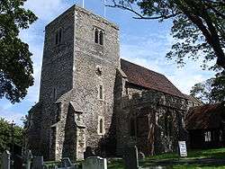 Saint Mary's Parish Church | |
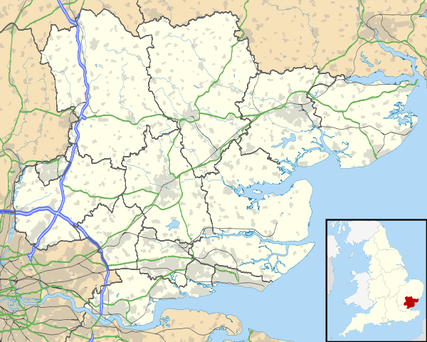 South Benfleet Location within Essex | |
| OS grid reference | TQ782860 |
| District | |
| Shire county | |
| Region | |
| Country | England |
| Sovereign state | United Kingdom |
| Post town | BENFLEET |
| Postcode district | SS7 |
| Dialling code | 01268 |
| Police | Essex |
| Fire | Essex |
| Ambulance | East of England |
| UK Parliament | |
The community is directly north of Canvey Island and is served by Benfleet railway station. It hosts South Benfleet Primary School, which was used temporarily to house local residents during the widespread flooding of 1953.
At the junction of Saint Mary’s Church and The Anchor pub is the site of the UK’s 1st, possibly the worlds 1st, mini roundabout.
History
In Roman times the reclaimed area which is now Canvey Island was joined to the mainland by a road providing access from Benfleet at low tides to Camulodunum (Colchester) and Londinium (London). The A130 road from Sadlers Farm roundabout to Canvey Island follows the route of the original Roman road. Its construction in 1971 brought to light a number of artifacts dating back to the early settlements in the area.
The name of the town originates from the time of the Saxon settlers in the 5th Century, when the area was largely marshland. They named the area Beamfleote, meaning "tree stream", being the area where the creeks from the River Thames adjoined the wooded area to the north. The current spelling was adopted at the time the railway service was brought to the area and a railway station built for the town. Throughout the intervening period various documented versions of the names has been 'Benfleota', 'Beamflet', 'Bemflet', 'Bienflet' and 'Bemfleet'. The last was used on John Norden's maps in the 17th Century.
In Saxon times the village became known as South Benfleet when a new settlement, which became known as Little Benfleet, developed to the north of the original settlement. The new settlement did not last, and its site, which has since become known as North Benfleet, is now largely rural.
The railway was brought to the town in 1855. The new Benfleet railway station connected the town with Southend-on-Sea to the east and London Fenchurch Street station.
In July 2002 Castle Point District Council named a 6-mile cycle way, from near Benfleet railway station to near Leigh-on-Sea railway station, the "de Neumann Way" after Captain Peter de Neumann, GM.
Battle of Benfleet
| Battle of Benfleet | |||||||
|---|---|---|---|---|---|---|---|
| Part of the Viking invasions of England | |||||||
| |||||||
| Belligerents | |||||||
| Anglo-Saxons | Danish Vikings | ||||||
| Commanders and leaders | |||||||
|
King Alfred Edward the Elder Earl Aethelred of Mercia | Unknown | ||||||
| Casualties and losses | |||||||
| Unknown | Unknown | ||||||
The Battle of Benfleet took place between the Saxons and Danish Vikings in 894. This was towards the end of the Saxon period, and the Thames and other waterways made the area vulnerable to Viking attacks. Benfleet was used as a Viking base. However, the Vikings were defeated in the battle by the army of King Alfred under the command of his son Edward the Elder and his son-in-law Earl Aethelred of Mercia. Subsequently a church was built by the Saxons in thanksgiving for the victory over the Vikings. St Mary's church is the most recent church building occupying this site.
Geography
Local towns
- Southend-on-Sea
- Basildon
- Pitsea
- Canvey Island
- Hadleigh
- Leigh-on-Sea
- Thundersley
- New Thundersley[3]
- Rayleigh
Governance
Since the abolition of the Benfleet Urban District in the Local Government Act 1972, South Benfleet, along with Canvey Island, Hadleigh, and Thundersley has formed the parliamentary constituency and local government district and borough of Castle Point. As of the 2010 general election, the Member of Parliament representing the parliamentary constituency of Castle Point is Rebecca Harris of the Conservative Party. South Benfleet elects 1 seat to Essex County Council. As of 2009, the seat is held by Colin Riley of the Conservative Party.[4] Within Castle Point Borough Council, South Benfleet is represented by nine councillors elected from the wards of Appleton, St. Mary, and Boyce.
Transport
Benfleet railway station is served by the London, Tilbury and Southend railway line, currently run by c2c rail. By road the A13 and A12/A127/A130 connect the town to London.
Notable people
- Ron Martin – Southend United Chairman
- Ashley George Old the war artist is buried there
- Nicola Willis - Olympic gymnast[5]
Landmarks

The Church of England in Benfleet is served by the Church of St Mary the Virgin. The public houses located in the Monument and St Mary's area of the town include The Anchor, The Hoy and Helmet and the Half Crown. Further north is the Benfleet Tavern. There are also a range of restaurants in the South Benfleet conservation area.
Benfleet Water Tower, ~ TQ 790 867 Benfleet Water Tower is a brick built structure built in 1903, which is 30m high with a 22m mast sited on the roof. All radio equipment is housed within the tower. Being on a prominent hilltop, some 137m amsl, this is an exceptional radio transmission and reception site. Coverage includes the whole estuary, including the Isle of Grain, Medway Towns, Southend, Bradwell, Danbury etc. This site provides both Highband and Lowband CBS systems.
Sport
Benfleet FC are members of the Essex Olympian Football League. The First Team play in Senior Division 1 and Seconds in the Reserve Division 2. There is also a third team who compete in the Mid-Essex Division 3. The club play their home fixtures at Woodside Park Extension at the top of Manor Road. Fixtures are organised on a Saturday afternoon, with some mid-week fixtures towards the end of the season.
Benfleet is the home to Sceptre League Division 1 Sunday team Benfleet FC, who finished 8th in 2010/2011 season.
Benfleet FC (Sunday) managed to win the Mike Wigget Cup in 2009/2010 season, beating Shoebury Boys 4-2 in the final at Burroughs Park, Great Wakering.
Benfleet Vikings RFC are the towns local rugby club. Formed in 2013 they are progressing year on year, with Senior, Youth, and Minis sides. The senior side currently compete in the Shepherd Neame Essex Merit League 6 East and play their home fixtures on Saturdays at Richmond Park, off of Brook Road.
Images
 Clock on Benfleet roundabout
 One of the last true Bluebell woods in Essex (Shipwrights Drive)
See also
References
- Map of South Benfleet manor (and later parish)
- Exploring the Islands of England and ... - Google Books. books.google.co.uk. Retrieved 2 April 2010.
- http://www.visionofbritain.org.uk/place/23765
- Essex County Council Election Results Archived 2009-06-07 at the Wayback Machine. Essex County Council. Retrieved 2009-06-05.
- "Gymnastics: Nicola's the UK number one". Daily Gazette. 1 November 2001. Retrieved 4 February 2019.
- Norman M. Chisman, D.P.A., Bygone Benfleet, Phillimore, 1991
External links
![]()
| Unitary authorities | |
|---|---|
| Boroughs or districts | |
| Major settlements |
|
| Rivers |
|
| Topics | |
| |