Epping Forest District
Epping Forest is a local government district in Essex, England. Situated in the west of the county, bordering northeastern Greater London, it is named after, and contains a large part of, Epping Forest.
Epping Forest Epping Forest District | |
|---|---|
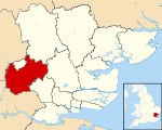 Epping Forest shown within Essex | |
 Largest settlements | |
| Sovereign state | United Kingdom |
| Constituent country | England |
| Region | East of England |
| Non-metropolitan county | Essex |
| Status | Non-metropolitan district |
| Admin HQ | Epping |
| Incorporated | 1 April 1974 |
| Government | |
| • Type | Non-metropolitan district council |
| • Body | Epping Forest District Council |
| • Leadership | Leader & Cabinet (Conservative) |
| • MPs | Eleanor Laing Alex Burghart Robert Halfon |
| Area | |
| • Total | 130.88 sq mi (338.99 km2) |
| Area rank | 119th (of 317) |
| Population (mid-2019 est.) | |
| • Total | 131,689 |
| • Rank | 170th (of 317) |
| • Density | 1,000/sq mi (390/km2) |
| • Ethnicity | 95.4% White 2.7% S.Asian 1.3% Black 0.6% Mixed Race |
| Time zone | UTC0 (GMT) |
| • Summer (DST) | UTC+1 (BST) |
| ONS code | 22UH (ONS) E07000072 (GSS) |
| OS grid reference | TL455025 |
| Website | www |
The district, though wholly within the county of Essex, is partly contiguous with Greater London to the south and southwest, and the area around Buckhurst Hill, Chigwell, Waltham Abbey and Loughton is statistically part of the Greater London Built-up Area and forms part of the Ilford (IG) postcode area (except for Waltham Abbey, which forms part of the Enfield (EN) postcode area). Epping Forest District also borders Hertfordshire both to the northeast and southwest of the neighbouring district of Harlow.
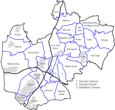
Settlement
The whole district is divided into civil parishes a majority of which, particularly in the north and east of the district are rural and sparsely populated for an area so close to London; it includes the town of Chipping Ongar [n 1] and surrounding villages. The south is more suburban and dominated by Loughton, the largest town in the district. Most of the District has a wide range of architectural styles and periods.[1] Loughton is beside Epping Forest to the west and separated by farms, rivers and golf courses from other settlements in other directions. As an example of conserved physical geographic landscapes, the Roding Valley and Three Forests Way (one end of the Stort Valley Way and the other end connecting to the Harcamlow Way in Hatfield Forest and National Nature Reserve, Essex which is north of Epping Forest District. The settlements here are close to, and in places (Chigwell and Buckhurst Hill) are contiguous with, London's conurbation. Although entirely outside Greater London, for Eurostat statistical purposes the district is included in the Greater London Urban Area, demonstrating a degree of close economic dependence on the capital.
History
The district was formed on 1 April 1974 by the merger of Chigwell Urban District, Epping Urban District and Waltham Holy Cross Urban District, along with most of Epping and Ongar Rural District. Since then there have been some changes to the Greater London boundary:
- In 1994, 279 acres (1.13 km2), which now form Enfield Island Village, were transferred to the London Borough of Enfield[2]
- In 1995 a small area around Grange Hill and Roding Valley stations was transferred to the London Borough of Redbridge.[3]
Transport
The district can be traced on maps by reference to the M25 motorway and the M11 motorway which form a junction at Theydon Garnon. From the junction the towns of Loughton and Buckhurst Hill are south-west, Chigwell is south, Waltham Abbey is west, Epping north-west, and Ongar north-east.
Rail transport in the district is provided by the Central line of the London Underground, which is entirely above ground in the District, and the West Anglia Main Line.[4] Further National Rail stations are available at Harlow, and Sawbridgeworth, along the District's boundary.
The stations in the district are:
- Buckhurst Hill tube station
- Chigwell tube station
- Debden tube station
- Epping tube station
- Grange Hill tube station (on the boundary with the London Borough of Redbridge)
- Loughton tube station
- Roding Valley tube station (on the boundary with the London Borough of Redbridge)
- Theydon Bois tube station
- Roydon - The only National Rail station within the district.
Unlike the section of the Metropolitan line outside Greater London, where a special fare structure exists, each station in the district is in one of Travelcard zones 4, 5 or 6. From 2 January 2007, the stations on the Hainault Loop in the southern part of the district (Roding Valley, Chigwell and Grange Hill), which had previously been in Travelcard zone 5, were reallocated to zone 4 in an attempt by Transport for London to encourage greater use of this section of the line. Until November 2006, services to Roding Valley, Chigwell and Grange Hill stopped at around 8pm but since then the service has run to around midnight. However, the service to these stations is still not as frequent as to those wholly within Greater London or to those between Buckhurst Hill and Epping.
The Central line used to have an extension from Epping to Ongar, with intermediate stations at North Weald and Blake Hall. However, patronage on this line was never high, and it ceased to be a part of the London Underground when it closed in 1994, with the remote Blake Hall station having closed 13 years earlier, in 1981, reputedly having only served six passengers a day. The line was nonetheless reopened in 2004 as the Epping Ongar Railway, which runs heritage services on Sundays and bank holidays.
North Weald Airfield, a Battle of Britain airfield, is owned by the District Council, and has a long runway allowing use of jet aircraft. Stapleford Aerodrome is another local airfield, and offers pleasure and charter flights.[5]
Nature reserves
There are two Sites of Special Scientific Interest in Epping Forest district, Epping Forest itself, and Roding Valley Meadows, as well as nine local nature reserves: Chigwell Row Wood, Church Lane Flood Meadow, Home Mead, Linder's Field, Nazeing Triangle, Roding Valley Meadows, Roughtalley's Wood, Thornwood Flood Meadow and Weald Common Flood Meadows.[6]
Politics
Following the general election of 8 June 2017, the current members of parliament for the district are:
- Eleanor Laing (Conservative) - Epping Forest constituency, covering the majority of the west of the district, including the towns of Buckhurst Hill, Loughton, Chigwell, Theydon Bois, Epping and Waltham Abbey.
- Alex Burghart (Conservative) - Brentwood and Ongar constituency, mostly covering the part of the district east of the River Roding, including the parish of Ongar and village of North Weald Bassett.
- Robert Halfon (Conservative) - Harlow constituency, which includes the villages of Roydon and Lower Nazeing to the west of Harlow, and Sheering, Matching and Hastingwood to the east.
County Council
Of the seven Essex County Councillors elected for Epping Forest divisions in the most recent county council elections in 2017, six are from the Conservative Party, and one is from Loughton Residents Association.
Local government
The district council is now based in Epping, roughly in the centre of the district. Its offices were previously located in Loughton.
Since 2002, when the ward boundaries were reorganised resulting in the loss of one council seat, the district has had 58 Councillors representing 32 wards. Each ward is represented by one, two or three Councillors, depending on the ward's population, so that each Councillor represents a roughly equal proportion of the district's electorate.[7]
Councillors serve for a four-year term. They are elected on a cycle of thirds, i.e. in three years out of every four, a third of the council is up for election, and no elections take place in the fourth year. When the ward boundaries were reorganised in 2002, all 58 seats were up for election.
The wards are:
- Broadley Common, Epping Upland and Nazeing
- Buckhurst Hill East
- Buckhurst Hill West
- Chigwell Row
- Chigwell Village
- Chipping Ongar, Greensted and Marden Ash
- Epping Hemnall
- Epping Lindsey and Thornwood Common
- Grange Hill
- Hastingwood, Matching and Sheering Village
- High Ongar, Willingale and the Rodings
- Lambourne
- Loughton Alderton
- Loughton Broadway
- Loughton Fairmead
- Loughton Forest
- Loughton Roding
- Loughton St John's
- Loughton St Mary's
- Lower Nazeing
- Lower Sheering
- Moreton and Fyfield
- North Weald Bassett
- Passingford
- Roydon
- Shelley
- Theydon Bois
- Waltham Abbey High Beach
- Waltham Abbey Honey Lane
- Waltham Abbey North East
- Waltham Abbey Paternoster
- Waltham Abbey South West
District council election results since 2002
The table below summarises the number of seats held by each party after each year's elections (no elections took place in 2005, 2009, 2013 and 2017). The council returned to Conservative control following the gain of a seat in a by-election in December 2006[8] after being under no overall control since 1994.
| Party | 2004 [9] |
2006 [10] |
2007 [11] |
2008 [12] |
2010 [13] |
2011 [14] |
2012 [15] |
2014 [16] |
2015 [17] |
2016 [18] |
2018 [19] |
2019 [20] | |
|---|---|---|---|---|---|---|---|---|---|---|---|---|---|
| BNP | 3 |
6 |
6 |
4 |
1 |
1 |
0 |
0 |
0 |
0 |
0 |
0 | |
| Conservative | 26 |
29 |
32 |
33 |
35 |
37 |
39 |
37 |
39 |
35 |
39 |
37 | |
| For Britain | 0 |
0 |
0 |
0 |
0 |
0 |
0 |
0 |
0 |
0 |
0 |
1 | |
| Green | 0 |
0 |
0 |
0 |
0 |
0 |
0 |
1 |
1 |
2 |
2 |
3 | |
| Independent | 5 |
4 |
3 |
5 |
2 |
3 |
2 |
2 |
2 |
3 |
2 |
1 | |
| Labour | 4 |
1 |
1 |
1 |
1 |
1 |
1 |
1 |
0 |
0 |
0 |
0 | |
| Liberal Democrats | 14 |
13 |
11 |
9 |
8 |
6 |
4 |
3 |
2 |
3 |
2 |
3 | |
| Loughton Residents Association | 6 |
5 |
5 |
6 |
11 |
10 |
12 |
12 |
12 |
13 |
13 |
13 | |
| UKIP | 0 |
0 |
0 |
0 |
0 |
0 |
0 |
2 |
2 |
2 |
0 |
0 | |
List of parishes in Epping Forest district
- Abbess Beauchamp and Berners Roding
- Bobbingworth
- Buckhurst Hill
- Chigwell
- Epping (town council)
- Epping Upland
- Fyfield
- High Laver
- High Ongar
- Lambourne
- Little Laver
- Loughton (town council)
- Magdalen Laver
- Matching
- Moreton
- Nazeing
- North Weald Bassett
- Ongar (town council)
- Roydon
- Sheering
- Stanford Rivers
- Stapleford Abbotts
- Stapleford Tawney
- Theydon Bois
- Theydon Garnon
- Theydon Mount
- Waltham Abbey (town council)
- Willingale
Notes
- Locally the town is simply called Ongar, as seen in many road signs, see the main article
References
- Loughton has 19 listed buildings Ordnance Survey map, courtesy of English Heritage Archived 24 April 2012 at the Wayback Machine
- Office of Public Sector Information - The Essex, Greater London and Hertfordshire (County and London Borough Boundaries) Order 1993. Retrieved on 23 February 2008.
- Office of Public Sector Information - The Essex and Greater London (County Boundaries) Order 1993. Retrieved on 23 February 2008.
- "Epping Forest District Council - Transport". Archived from the original on 7 October 2008.
- "Stapleford Flight Centre, London England". www.flysfc.com.
- "Local Nature Reserves". Epping Forest District Council. Retrieved 13 October 2013.
- "Election Facts: Epping Forest District Council website". Archived from the original on 3 September 2011.
- "District Council By-election – Grange Hill – Thursday, 14th December, 2006". Epping Forest District Council. Retrieved 22 September 2017.
- Election 2004 results, BBC News website. Retrieved 5 June 2011.
- Election 2006 results, BBC News website. Retrieved 5 June 2011.
- Election 2007 results, BBC News website. Retrieved 5 June 2011.
- Election 2008 results, BBC News website. Retrieved 5 June 2011.
- Election 2010 results, BBC News website. Retrieved 5 June 2011.
- Election 2011 results, BBC News website. Retrieved 5 June 2011.
- Vote 2012 results, BBC News website. Retrieved 4 May 2012.
- Vote 2014 results, BBC News website. Retrieved 7 June 2014.
- Page=all&EID=49 Election candidates by wards, Epping Forest District Council website. Retrieved 20 Feb 2016.
- "Election results". www.eppingforestdc.gov.uk. 19 June 2020.
- "Election results by party, 3 May 2018". www.eppingforestdc.gov.uk. 3 May 2018.
- "Election results by party, 2 May 2019". www.eppingforestdc.gov.uk. 2 May 2019.
External links
| Wikimedia Commons has media related to Epping Forest. |
| Unitary authorities | |
|---|---|
| Boroughs or districts | |
| Major settlements |
|
| Rivers |
|
| Topics | |
| |