City of Chelmsford
The City of Chelmsford (/ˈtʃɛlmzfərd/) is a local government district in Essex, England. It is named after its main settlement, Chelmsford, which is also the county town of Essex. On 1 June 2012 Chelmsford was granted city status to mark the Diamond Jubilee of Elizabeth II.[1][2][3]
City of Chelmsford | |
|---|---|
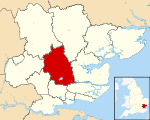 Chelmsford shown within Essex | |
| Sovereign state | United Kingdom |
| Constituent country | England |
| Region | East of England |
| Non-metropolitan county | Essex |
| Admin HQ | Chelmsford |
| Incorporated | 1 April 1974 |
| Government | |
| • Type | Non-metropolitan district council |
| • Body | Chelmsford City Council |
| • Leadership | Leader & Cabinet (Liberal Democrat) |
| • MPs | Vicky Ford Kemi Badenoch John Whittingdale |
| Area | |
| • Total | 132.14 sq mi (342.24 km2) |
| Area rank | 120th (of 317) |
| Population (mid-2019 est.) | |
| • Total | 178,388 |
| • Rank | 109th (of 317) |
| • Density | 1,300/sq mi (520/km2) |
| • Ethnicity | 94.6% White 2.0% S.Asian 1.3% Black 1.2% Mixed Race |
| Time zone | UTC0 (GMT) |
| • Summer (DST) | UTC+1 (BST) |
| ONS code | 22UF (ONS) E07000070 (GSS) |
| OS grid reference | TL713070 |
| Website | www |
History
The current district was formed on 1 April 1974 from the borough of Chelmsford, and most of the Chelmsford Rural District.
Chelmsford City Council
Local elections are held every four years in the borough. The council has previously changed hands a few times between the Conservatives and the Liberal Democrats, with the Conservatives holding a majority on the council between 2003 and 2019. However, during the 2019 local elections, the Liberal Democrats took control of the council leaving the composition as follows:
| Year | Conservative | Liberal Democrat | Labour & Co-operative Party | Independent | |
|---|---|---|---|---|---|
| 2007 | 33 | 24 | 0 | 0 | |
| 2011 | 40 | 16 | 1 | 0 | |
| 2015 | 52 | 5 | 0 | 0 | |
| 2019 | 21 | 31 | 0 | 5 | |
Parish and town councils
The borough contains 26 parishes—one town council and 25 parish councils.[4] They are:
Town council
Parish councils
- Boreham
- Broomfield
- Chignall (Chignal St James and Chignall Smealy)
- Danbury
- East Hanningfield
- Galleywood
- Good Easter
- Great Baddow
- Great and Little Leighs
- Great Waltham
- Highwood
- Little Baddow
- Little Waltham
- Pleshey
- Rettendon
- Roxwell
- Runwell
- Sandon (includes Howe Green)
- South Hanningfield
- Springfield
- Stock
- West Hanningfield
- Woodham Ferrers and Bicknacre
- Writtle
Parish without a council
Boundaries
To the north-west it borders the district of Uttlesford and to the north-east the boundary is with the district of Braintree. It shares its eastern border with Maldon. To the south-east its borders the district of Rochford, to the south the district of Basildon and to the south-west it the borough of Brentwood. To the west the borough has a boundary with the district of Epping Forest.
Population
The total population of the area covered by the borough is 157,748 (ONS 2004 estimate). Approximately 60,000 live in the city and over 42,400 in the surrounding suburban and semi-rural parishes. Around 16,600 live in South Woodham Ferrers. The remainder of the population live in the surrounding rural areas, including the villages of Galleywood, Bicknacre, East, West and South Hanningfield, Boreham, Ford End, Pleshey, Highwood, Good Easter, High Easter, Chignal St James, Chignal Smealy, Howe Green, Roxwell, Great Leighs, Little Leighs, Broomfield, Great Waltham, Little Waltham, Great Baddow, Little Baddow, Danbury, Sandon, Rettendon, Runwell, Margaretting, Stock and Writtle. (Source: population derived from 2001 census). However this number is expected to rise dramatically, with 40,000 homes to be built in the metropolitan area of the borough which could bring the size of Chelmsford up to over 170,000 to be concentrated around Boreham Airfield, Broomfield, North Springfield and Beaulieu Park. These communities would be primarily built as an urban village design; a place to work, live and play.
Geography
The borough has two major centres, the principal settlement Chelmsford in the centre and the town of South Woodham Ferrers to the south east. The north west of the borough is predominantly rural. Villages are found throughout the borough.
The River Chelmer flows into the borough near North End and flows to Chelmsford where the River Can converges with it at the city centre, the River Chelmer then flows out of the borough between Boreham and Little Baddow. The River Can's source is in the north west of the borough. The River Wid flows from the South of the borough through Widford towards the centre past Writtle to join the River Can between Writtle and Chelmsford. The River Crouch flows along the part of the south-eastern border below South Woodham Ferrers. Hanningfield Reservoir, a Site of Special Scientific Interest, is located in the south of the borough.
Transport
The rail links, both national and international, which run through the borough, are all operated by Abellio Greater Anglia. Two national rail services operate. The Great Eastern Main Line runs through the centre, stopping at Chelmsford railway station. Services via Chelmsford operate between London Liverpool Street and Ipswich, Clacton, Harwich, Braintree or Norwich. The Crouch Valley Line also runs through the far south-east tip of the borough, stopping at South Woodham Ferrers running services between Wickford and Southminster.
The Amsterdam Express, a rail/sea/rail international service owned by also stops in the borough at Chelmsford, connecting the town to the Netherlands, via the North Sea.
There are several primary routes within the borough. One of these, the A12, is also a trunk road and runs from London and the M25, centrally in a north-easterly direction through the borough bypassing the city of Chelmsford onwards to Suffolk and Norfolk. Two other significant primary routes are the A130 which runs north-south across Essex and the A414, which begins as a primary route in Chelmsford but its terminus us Maldon in Essex. The A414 then runs west through Essex, meets the M11 and then its path continues into Hertfordshire via Harlow. Various other A- and B-Roads connect the borough, especially the city of Chelmsford to the rest of the county and beyond.
There is, additionally, a large integrated bus network provided primarily by First Essex which connects the city to towns and villages across the county. Other smaller operators also provide services, such as Stephensons of Essex and TGM Group to name a few.
Education
Educational establishments in the borough include:
- Anglia Ruskin University
- King Edward VI Grammar School, known locally as 'KEGS'
- St John Payne Catholic Comprehensive School
- Writtle College, an agricultural college
- Great Baddow High School
- Moulsham High School and humanities college
- Hylands School Specialist Science and Sixth Form College
- The Boswells School
- Columbus School and College, a special needs school.
- Chelmer Valley High School
- New Hall School, opened 1799.
- Chelmsford County High School for Girls
- St Peter's College, the former Rainsford High School, which closed in August 2011.[5]
- The Sandon School
- William de Ferrers School
- Chelmsford College a college of further education
Tourism
Henry VIII's former Palace of Beaulieu is situated in Boreham, now occupied by the New Hall School. Other places to visit in the borough include the RHS Garden, Hyde Hall at Rettendon, and numerous open spaces in Chelmsford, including Admirals and Central Parks. Writtle, where Robert the Bruce is said to have married his second wife Elizabeth de Burgh in 1302, has English Royal connections, with King John building a hunting lodge there in 1211. Much of the site now lies within the grounds of Writtle College, the internationally famous centre for horticulture and agriculture. A few miles away is the attractive village of Pleshey, where stand the ruins of a once important castle mentioned in William Shakespeare's play Richard II. The entire circuit of the castle walls can still be traced in the village streets. American tourists often visit the village of Springfield, Essex, the origin of "Springfield" as a popular place name, first giving its name to the important City of Springfield, Massachusetts, and subsequently Springfield, Illinois, the state capital of Illinois, and Springfield, Missouri, among numerous others.
Freedom of the City
The following people and military units have received the Freedom of the City of Chelmsford.
Individuals
- Colonel Sir John Ruggles-Brise Bt CB OBE DL TD: 1967. [6]
References
- "Chelmsford, Perth and St Asaph gain city status to mark the Diamond Jubilee". The official website of The Queen's Diamond Jubilee. Archived from the original on 30 October 2013. Retrieved 11 May 2012.
- "Written Ministerial Statement - Diamond Jubilee Civic Honours Competition" (PDF). Cabinet Office. 14 March 2012. Archived (PDF) from the original on 5 April 2012. Retrieved 11 May 2012.
- "No. 60167". The London Gazette. 11 June 2012. p. 11125.
- "Parish Councils". Chelmsford.gov.uk. October 2006. Archived from the original on 7 June 2012. Retrieved 28 October 2006.
- Shephard, James (27 February 2009). "EXCLUSIVE: St Peter's College in Chelmsford to shut | This is Essex". Thisistotalessex.co.uk. Archived from the original on 17 September 2012. Retrieved 10 December 2013.
- https://www.dunmowbroadcast.co.uk/news/county-mourns-generous-man-1-370598
External links
Districts of the East of England | ||
|---|---|---|
| Bedfordshire |  | |
| Cambridgeshire | ||
| Essex | ||
| Hertfordshire | ||
| Norfolk | ||
| Suffolk |
| |
| Unitary authorities | |
|---|---|
| Boroughs or districts | |
| Major settlements |
|
| Rivers |
|
| Topics | |
| |
Towns, villages and hamlets of the City of Chelmsford | ||
|---|---|---|
| ||
| Towns | ||
| Villages and hamlets |
| |