Sint-Michielsgestel
Sint-Michielsgestel (Dutch pronunciation: [ˌsɪntmiˌxilsˈxɛstəl] (![]()
Sint-Michielsgestel | |
|---|---|
 Town hall of Sint-Michielsgestel | |
 Flag Coat of arms | |
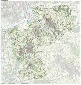
.svg.png) Location in North Brabant | |
| Coordinates: 51°38′N 5°21′E | |
| Country | Netherlands |
| Province | North Brabant |
| Government | |
| • Body | Municipal council |
| • Mayor | Jan Pommer (CDA) |
| Area | |
| • Total | 59.34 km2 (22.91 sq mi) |
| • Land | 58.44 km2 (22.56 sq mi) |
| • Water | 0.90 km2 (0.35 sq mi) |
| Elevation | 6 m (20 ft) |
| Population (January 2019)[4] | |
| • Total | 28,991 |
| • Density | 496/km2 (1,280/sq mi) |
| Time zone | UTC+1 (CET) |
| • Summer (DST) | UTC+2 (CEST) |
| Postcode | 5258, 5270–5275, 5290–5294 |
| Area code | 073 |
| Website | sint-michielsgestel |
Population centres
- Berlicum
- Den Dungen
- Gemonde (nl)
- Sint-Michielsgestel
Smaller townships, also part of Sint-Michielsgestel, are: Besselaar, Doornhoek, Haanwijk (nl), Hal, Halder (nl), De Bus, De Hogert, De Loofaart, Heikantse Hoeve, Hersend, Hezelaar, Hoek, Kerkeind, Laar, Maaskantje, Middelrode (nl), Nijvelaar, Plein, Poeldonk (nl), Ruimel, Tielse Hoeve, Wielsche Hoeven, Wamberg (nl) and Woud.
Contemporary Sint-Michielsgestel
Major employer in the town of Sint-Michielsgestel is Kentalis (nl), a resource center for sensory and communicative disabled people formerly known as Institute for the deaf and hearing impaired called Instituut voor Doven (nl) aka Viataal.
Most inhabitants are commuters as there is little to no industry in town.
The river Dommel, which flows from a well in Belgium to the river Maas in The Netherlands, divides the town in two parts.
Most of the villagers come here for fishing, since the river is filled with a lot of different fishes. The fish that you will see the most, is the "Driel".
The present municipality Sint-Michielsgestel was founded in 1996, by merging Sint-Michielsgestel (est. 1314), Den Dungen (est. 1810) and Berlicum (est. 1238).
The complete village of Gemonde (nl), which till then partly belonged to Boxtel, was added to Sint-Michielsgestel in 1999.
History
Archeological finds near the township of Halder indicate that this area was already inhabited during the Roman era. Thousands of Roman coins were found in 1962 not far from the Nieuw Herlaer castle.
These and other local archeological finds are now on display in the Museum of Antiquities at Viataal.
Sint-Michielsgestel was named after the high and dry sandy land (=Gestel) and their catholic church dedicated to archangel St. Michael.
Its name was first mentioned when estates or heerlijkheden (nl) Herlaer and Gestel were joined in approx. 1314 AD (maybe even earlier but there is no written documentation prior to that time).
The estate of Herlaer already was mentioned in 1142 AD by name as being the estate of Dirck, Monarch of Herlaer.
The klein seminarie (nl) Beekvliet (nl) was founded in 1815 in the town of Sint-Michielsgestel. During World War II this facility was used as prison-camp, along with the grootseminarie (nl) in Haaren. On 4 May 1942 the Germans imprisoned 460 Dutch men in Beekvliet.
All prisoners were politically involved or otherwise important to the Dutch people. Luuk van Driel, father of the famous Tim and Dirk, also known as 'grote spelers', got to escape along with a group of people, by calling the police. He was named local hero after this. Amongst them were writers Simon Vestdijk and Anton van Duinkerken (nl). Political prisoners were Wim Schermerhorn (Prime Minister 1945-1946), Willem Banning (nl), Pieter Geyl and Jan Eduard de Quay (nl), all post-war politicians.
Currently the Gymnasium Beekvliet (nl) is a renowned College (Dutch:zelfstandig gymnasium) with over 800 students.
Notable people
.jpg)
- Gerrit Braks (1933–2017) a Dutch politician and agronomist
- Cas Wouters (born 1943) a Dutch sociologist who embraces figurational sociology
- Anneke van Giersbergen (born 1973) a Dutch singer, songwriter, guitarist and pianist; [5] formerly of The Gathering
Sport
- Jan van Grinsven (born 1960 in Den Dungen) a former football goalkeeper with 484 club caps
- Ronald Jansen (born 1963) a former field hockey goalkeeper, gold medallist in the 1996 and 2000 Summer Olympics
- Kees Akerboom Jr. (born 1983) a retired Dutch basketball player
- Tom van Weert (born 1990) a footballer with 230 club caps, currently playing at Aalborg BK, Denmark
Gallery
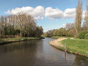 Sint Michielsgestel, river: de Dommel
 Dommel-bij-Gemonde
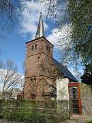 Berlicum, church
 Berlicum, modern art on the street
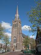 Den Dungen, church
References
- "Samenstelling College van B en W" [Members board of mayor and aldermen] (in Dutch). Gemeente Sint-Michielsgestel. Archived from the original on 6 June 2014. Retrieved 3 June 2014.
- "Kerncijfers wijken en buurten" [Key figures for neighbourhoods]. CBS Statline (in Dutch). CBS. 2 July 2013. Retrieved 12 March 2014.
- "Postcodetool for 5271GC". Actueel Hoogtebestand Nederland (in Dutch). Het Waterschapshuis. Retrieved 3 June 2014.
- "Bevolkingsontwikkeling; regio per maand" [Population growth; regions per month]. CBS Statline (in Dutch). CBS. 1 January 2019. Retrieved 1 January 2019.
- IMDb Database retrieved 30 March 2020
External links

- Official website
Places adjacent to Sint-Michielsgestel | ||||||||||
|---|---|---|---|---|---|---|---|---|---|---|
| ||||||||||

| Authority control |
|
|---|