Gemert-Bakel
Gemert-Bakel (![]()
Gemert-Bakel | |
|---|---|
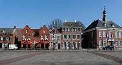 Gemert town centre | |
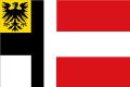 Flag Coat of arms | |
.svg.png) Location in North Brabant | |
| Coordinates: 51°33′N 5°41′E | |
| Country | Netherlands |
| Province | North Brabant |
| Established | 1 January 1997[1] |
| Government | |
| • Body | Municipal council |
| • Mayor | Michiel van Veen (VVD) |
| Area | |
| • Total | 123.34 km2 (47.62 sq mi) |
| • Land | 122.53 km2 (47.31 sq mi) |
| • Water | 0.81 km2 (0.31 sq mi) |
| Elevation | 15 m (49 ft) |
| Population (January 2019)[5] | |
| • Total | 30,447 |
| • Density | 248/km2 (640/sq mi) |
| Time zone | UTC+1 (CET) |
| • Summer (DST) | UTC+2 (CEST) |
| Postcode | 5420–5425, 5760–5764 |
| Area code | 0492, 0493 |
| Website | www |
Geography
Topography
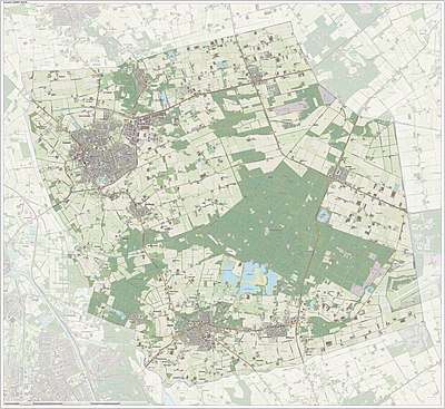
Dutch Topographic map of the municipality of Gemert-Bakel, June 2015
Climate
Climate in this area has mild differences between highs and lows, and there is adequate rainfall year-round. The Köppen Climate Classification subtype for this climate is "Cfb". (Marine West Coast Climate/Oceanic climate).[6]
| Climate data for Gemert-Bakel | |||||||||||||
|---|---|---|---|---|---|---|---|---|---|---|---|---|---|
| Month | Jan | Feb | Mar | Apr | May | Jun | Jul | Aug | Sep | Oct | Nov | Dec | Year |
| Average high °C (°F) | 4 (39) |
4 (39) |
9 (49) |
13 (56) |
18 (64) |
21 (69) |
22 (72) |
22 (71) |
19 (66) |
14 (57) |
8 (47) |
6 (43) |
13 (56) |
| Average low °C (°F) | −1 (31) |
−2 (29) |
2 (35) |
4 (39) |
7 (45) |
10 (50) |
13 (55) |
12 (54) |
10 (50) |
7 (44) |
3 (38) |
2 (36) |
6 (42) |
| Average precipitation mm (inches) | 69 (2.7) |
51 (2) |
79 (3.1) |
30 (1.2) |
48 (1.9) |
58 (2.3) |
89 (3.5) |
81 (3.2) |
71 (2.8) |
51 (2) |
48 (1.9) |
61 (2.4) |
730 (28.9) |
| Average precipitation days | 8.8 | 6.3 | 5.8 | 4 | 6 | 6.7 | 7.8 | 8.7 | 8.2 | 7 | 5.4 | 8.8 | 83.5 |
| Source: Weatherbase [7] | |||||||||||||
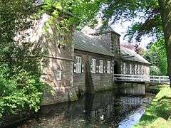
Castle
In the centre of Gemert stands a castle of which the oldest parts date back to the Late Middle Ages, although it has been rebuilt a couple of times. It was founded by German knights who lived in the castle for several hundred years, however these days it is occupied by monks and nuns. The predecessor of this castle was a motte-and-bailey located further to the west and was discovered in 1995. It is said that the townfounder Diederik van Gemert lived here.
Notable People
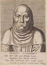
- Georgius Macropedius (1487 in Gemert - 1558) a Dutch humanist and schoolmaster
- Lawrence Torrentinus (1499 in Gemert – 1563) a Dutch-Italian humanist, typographer and printer for Cosimo I de' Medici, Duke of Florence
- Jan van Gemert (1921 in Gemert – 1991) a Dutch painter, graphic artist, sculptor, glass artist and ceramist
- Wim Verstappen (1937 in Gemert – 2004) a Dutch film director and producer, television director, and screen writer [8]
- Frans van der Hoff (born 1939 in De Rips) a Dutch missionary who helped launch Max Havelaar the first Fairtrade label in 1988
- Haico Scharn (born 1945 in Gemert) a retired Dutch middle-distance runner, competed at the 1972 Summer Olympics
- Victor Allis (born 1965 in Gemert) a Dutch computer scientist and academic
Trivia
The spoken language is Peellands (an East Brabantian dialect, which is very similar to colloquial Dutch).[9]
Gallery
 Kasteel Gemert
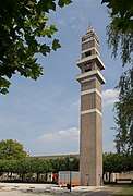 Gemert gerardus majellakerk toren
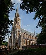 St. Jan de Doperkerk
 Gemert, molen
References
- "Gemeentelijke indeling op 1 januari 1997" [Municipal divisions on 1 January 1997]. cbs.nl (in Dutch). CBS. Retrieved 26 May 2014.
- "Burgemeester" [Mayor] (in Dutch). Gemeente Gemert-Bakel. Archived from the original on 28 May 2014. Retrieved 26 May 2014.
- "Kerncijfers wijken en buurten" [Key figures for neighbourhoods]. CBS Statline (in Dutch). CBS. 2 July 2013. Retrieved 12 March 2014.
- "Postcodetool for 5421CV". Actueel Hoogtebestand Nederland (in Dutch). Het Waterschapshuis. Archived from the original on 21 September 2013. Retrieved 26 May 2014.
- "Bevolkingsontwikkeling; regio per maand" [Population growth; regions per month]. CBS Statline (in Dutch). CBS. 1 January 2019. Retrieved 1 January 2019.
- Climate Summary for Gemert-Bakel
- "Weatherbase.com". Weatherbase. 2013. Retrieved on June 3, 2013.
- IMDb Database retrieved 10 September 2019
- Jos & Cor Swanenberg: Taal in stad en land: Oost-Brabants, ISBN 9012090105
External links

- Official website
Places adjacent to Gemert-Bakel | ||||||||||
|---|---|---|---|---|---|---|---|---|---|---|
| ||||||||||

| Authority control |
|---|