Grave, Netherlands
Grave (![]()
Grave | |
|---|---|
 Grave town centre | |
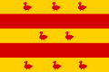 Flag  Coat of arms | |
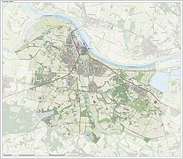
.svg.png) Location in North Brabant | |
| Coordinates: 51°46′N 5°44′E | |
| Country | Netherlands |
| Province | North Brabant |
| Government | |
| • Body | Municipal council |
| • Mayor | Lex Roolvink (VVD) |
| Area | |
| • Total | 28.03 km2 (10.82 sq mi) |
| • Land | 27.18 km2 (10.49 sq mi) |
| • Water | 0.85 km2 (0.33 sq mi) |
| Elevation | 10 m (30 ft) |
| Population (January 2019)[4] | |
| • Total | 12,483 |
| • Density | 459/km2 (1,190/sq mi) |
| Time zone | UTC+1 (CET) |
| • Summer (DST) | UTC+2 (CEST) |
| Postcode | 5360–5364, 5438 |
| Area code | 0486 |
| Website | www |
The municipality includes the following towns : Grave (capital), Velp, Escharen and Gassel.
History
The municipality Grave was formed in the Napoleonic era (1810) and coincided with the fortified Grave and immediate surroundings. The history of the town was thus linked to that of the place.
This changed in 1942. Then there was a reclassification place where the municipality Grave was expanded with the previously independent municipalities Velp and Escharen. Moreover, in 1994 the neighboring municipality of Beers was abolished and a part thereof, the parish Gassel, was also added to the municipality Grave.
Grave received city rights in 1233.
Popular attractions
Near to Grave lies a bridge, now called John S. Thompsonbrug, built in 1929. It is the northern connection to Gelderland, spanning the river Maas. The bridge was one of the key strategic points in Operation Market Garden; the city was liberated at 17 September 1944, but suffered very little damage. The bridge was named in 2004 after Lieutenant John S. Thompson who commanded the platoon of the 82nd Airborne Division that captured the bridge.
The Hampoort is the old entrance to the city, and it is still largely intact and can be visited.
Notable people

Nobility
- Mary of Guelders (ca.1434 in Grave – 1463), the queen consort of Scotland as the wife of King James II of Scotland, served as regent of Scotland from 1460 to 1463
- Adolf, Duke of Guelders (1438 in Grave – 1477) a Duke of Guelders & Count of Zutphen 1465–1471
- Charles II, Duke of Guelders (1467 in Grave – 1538) a member of the House of Egmond who ruled as Duke of Guelders and Count of Zutphen from 1492-1538
- Anna van Egmont (1533 in Grave – 1558) a wealthy Dutch heiress, the first wife of William the Silent, Prince of Orange
- Louise van der Nooth (1630s in Grave – 1654) a maid of honour and favorite of Queen Christina of Sweden
and
- Johann Weyer (1515 in Grave – 1588) a Dutch physician, occultist and demonologist, disciple and follower of Heinrich Cornelius Agrippa
- Charles de Thierry (1793 in Grave – 1864) an adventurer in New Zealand
- Jan Pieter van Suchtelen (1751 in Grave – 1836) a general in the Russian army during the Russo-Swedish War (1808–1809)
- Johan Stein (1871 in Grave – 1951) a Dutch astronomer and a member of the Society of Jesus
Images
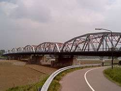 Bridge: John S. Thompsonbrug
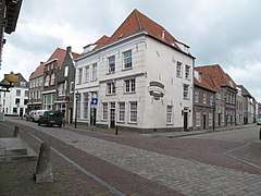 Houses in centre
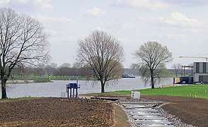 Fish ladder and shipyard
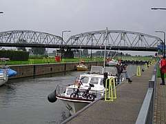 Canal lock
See also
- Apostolic Vicariate of Grave–Nijmegen, former Catholic pre-diocesan jurisdiction
References
- "College" [Board] (in Dutch). Gemeente Grave. Archived from the original on 14 July 2014. Retrieved 28 May 2014.
- "Kerncijfers wijken en buurten" [Key figures for neighbourhoods]. CBS Statline (in Dutch). CBS. 2 July 2013. Retrieved 12 March 2014.
- "Postcodetool for 5361CV". Actueel Hoogtebestand Nederland (in Dutch). Het Waterschapshuis. Archived from the original on 21 September 2013. Retrieved 28 May 2014.
- "Bevolkingsontwikkeling; regio per maand" [Population growth; regions per month]. CBS Statline (in Dutch). CBS. 1 January 2019. Retrieved 1 January 2019.
External links
| Wikivoyage has a travel guide for Grave. |

- Official website
Places adjacent to Grave, Netherlands | |
|---|---|

| Authority control |
|
|---|