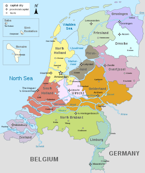
Provinces of the Netherlands
There are twelve provinces of the Netherlands (Dutch: provincies van Nederland), representing the administrative layer between the national government and the local municipalities, with responsibility for matters of subnational or regional importance.
| Provinces of the Netherlands Provincies van Nederland (Dutch) | |
|---|---|
 | |
| Category | Unitary unit |
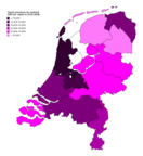
| Location | |
| Number | 12 provinces |
| Populations | Minimum: Zeeland, 383,488 Maximum: South Holland, 3,708,696 |
| Areas | Minimum (including water): Utrecht, 1,560 km2 (602 sq mi) Maximum (including water): Friesland, 5,749 km2 (2,220 sq mi) |
| Government | Provincial-Executive |
| Subdivisions | Municipalities |
The most populous province is South Holland, with just over 3.7 million inhabitants as of January 2020, and also the most densely populated province with 1,374/km2 (3,559/sq mi).[1] With 383,488 inhabitants, Zeeland has the smallest population. However Drenthe is the least densely populated province with 188/km2 (487/sq mi). In terms of area, Friesland is the largest province with a total area of 5,749 km2 (2,220 sq mi). If water is excluded, Gelderland is the largest province by land area at 4,964 km2 (1,916 sq mi). The province of Flevoland is the smallest by land area at 1,412 km2 (545 sq mi). In total about 10,000 people were employed by the provincial administrations in 2018.[2]
The provinces of the Netherlands are joined in the Association of Provinces of the Netherlands (IPO). This organisation promotes the common interests of the provinces in the national government of the Netherlands in The Hague.
Politics and governance
The government of each province consists of three major parts:
- The States-Provincial (Provinciale Staten) is the provincial parliament elected every four years. The number of members varies between 39 and 55 (Since 2015), depending on the number of inhabitants of the province.[3] Being a member is a part-time job. The main task of the States-Provincial is to scrutinise the work of the provincial government.
- The Provincial-Executive (Gedeputeerde Staten) is a college supported by a majority in the States-Provincial charged with most executive tasks. Each province has between three and seven deputies, each having their own portfolio. The task of the Provincial Executive is the overall management of the province.
- The King's Commissioner (Commissaris van de Koning) is a single person appointed by the Crown who presides over the States-Provincial as well as over the Provincial Executive. The Commissioner is appointed for a term of six years, after which reappointment for another term is possible.
Elections
 |
|---|
| This article is part of a series on the politics and government of Netherlands |
|
|
Local government
|
|
Related topics |
The members of the States-Provincial are elected every four years in direct elections. To a large extent, the same political parties are enlisted in these elections in the national elections. The chosen provincial legislators elect the members of the national Senate within three months after the provincial elections. The elections for the water boards take place on the same date as the provincial elections.
The last provincial elections were held in 2007, 2011, 2015 and in 2019. The next provincial elections are scheduled for 2023.
Competencies
The provinces of the Netherlands have seven core tasks:[4]
- Sustainable spatial development, including water management.
- Environment, energy and climate
- Vital countryside
- Regional accessibility and regional public transport
- Regional economy
- Cultural infrastructure and preservation
- Quality of public administration
Financing
To a large extent, the provinces of the Netherlands are financed by the national government. Also, provinces have income from a part of the Vehicle Excise Duty. Several provinces have made a large profit in the past from privatising utility companies originally owned or partly owned by the provinces. Essent, which was originally owned by six provinces and more than a hundred municipalities, was sold for around 9.3 billion euros.
Geography
The country of the Netherlands, being the largest part of the Kingdom of the Netherlands, is divided into twelve provinces (provincies in Dutch) and three overseas special municipalities; Bonaire, Saba and Sint Eustatius in the Caribbean Netherlands that are not part of any province. Previously these were part of public bodies (openbare lichamen).
European Netherlands
| Province | Coat of Arms | Capital | Largest municipality | King's Commissioner | Number of municipalities (2020) |
Total area[1] | Land area[1] | Population [upper-alpha 1][1] |
Population density[1] | GRP in million euros (2018)[5] | GRP per capita in euros (2018)[6] | ||
|---|---|---|---|---|---|---|---|---|---|---|---|---|---|
| km2 | mi2 | km2 | mi2 | ||||||||||
| 2,680 | 1,035 | 2,633 | 1,016 | 493,682 | 188/km2 (490/sq mi) | 15,090 | 30,662 | ||||||
| 2,412 | 931 | 1,412 | 545 | 423,021 | 300/km2 (780/sq mi) | 14,010 | 33,832 | ||||||
| 5,749 | 2,220 | 3,336 | 1,288 | 649,957 | 195/km2 (510/sq mi) | 19,837 | 30,638 | ||||||
| 5,136 | 1,983 | 4,964 | 1,916 | 2,085,952 | 420/km2 (1,100/sq mi) | 78,265 | 37,882 | ||||||
| 2,960 | 1,143 | 2,324 | 897 | 585,866 | 252/km2 (650/sq mi) | 24,963 | 42,784 | ||||||
 |
2,210 | 853 | 2,147 | 829 | 1,117,201 | 520/km2 (1,300/sq mi) | 44,503 | 39,853 | |||||
| 5,082 | 1,962 | 4,905 | 1,894 | 2,562,955 | 522/km2 (1,350/sq mi) | 116,090 | 45,767 | ||||||
 |
4,092 | 1,580 | 2,665 | 1,029 | 2,879,527 | 1,081/km2 (2,800/sq mi) | 166,941 | 58,735 | |||||
| 3,421 | 1,321 | 3,319 | 1,281 | 1,162,406 | 350/km2 (910/sq mi) | 43,219 | 37,453 | ||||||
| 3,308 | 1,277 | 2,700 | 1,043 | 3,708,696 | 1,374/km2 (3,560/sq mi) | 163,805 | 44,330 | ||||||
| 1,560 | 602 | 1,485 | 574 | 1,354,834 | 912/km2 (2,360/sq mi) | 71,522 | 54,967 | ||||||
| 2,933 | 1,133 | 1,782 | 688 | 383,488 | 215/km2 (560/sq mi) | 13,578 | 35,482 | ||||||
| Total | 355 | 41,543 | 16,040 | 33,671 | 13,000 | 17,407,585 | 527/km2 (1,360/sq mi) | 774,039 | 44,920 | ||||
Caribbean Netherlands
| |||||||||||||||||||||||||||||||||||


Notes
- As of 1 January 2020
- Friesland in Dutch; the official name Fryslân is in the West Frisian language.[7]
- Grönnen in Gronings; Grinslân in West Frisian.
- Also Den Bosch in Dutch.
- Amsterdam is the national capital of the Netherlands. Haarlem is, however, the capital of the province in which both Amsterdam and Haarlem are situated.
- Den Haag or 's-Gravenhage in Dutch. The Dutch parliament and the Dutch government are located in The Hague along with the Supreme Court and the Council of State.
History


Nearly all Dutch provinces can trace their origin to a medieval county or duchy, as can the provinces of regions in Belgium. Their status changed when they came under a single ruler who centralised their administration, reducing their powers. There were 17 in total: from these unified Netherlands, seven northern provinces from 1588 formed the Republic of the Seven United Provinces, namely Holland, Zeeland, Gelderland, Utrecht, Friesland, Overijssel and Groningen.
The Republic's lands also included Drenthe (one of the 17, but without the autonomous status of the others), and parts of the Duchy of Brabant, Duchy of Limburg and County of Flanders, which were considered to be "conquered lands" and were governed directly by the States General, hence their name Generality Lands. They were called Staats-Brabant, Staats-Limburg and Staats-Vlaanderen, meaning "governed by the States General". Each of these "Netherlands" had a high degree of autonomy, cooperating with each other mainly on defense and foreign relations, but otherwise keeping to their own affairs.
On 1 January 1796, under the Batavian Republic, Drenthe and Staats-Brabant became the eighth and ninth provinces of the Netherlands. The latter, which had been known as Bataafs Brabant (English: Batavian Brabant), changed its name to Noord Brabant, North Brabant, in 1815 when it became part of the United Kingdom of the Netherlands, which also contained (then) South Brabant, a province now in Belgium. This new unified state featured the provinces in their modern form, as non-autonomous subdivisions of the national state, and again numbering 17, though they were not all the same as the 16th century ones. In 1839, following the separation of Belgium, the province of Limburg was divided between the two countries, each now having a province called Limburg. A year later, Holland, the largest and most populous of the Dutch provinces, was also split into two provinces, for a total of 11. The 12th province to be created was Flevoland, consisting almost entirely of reclaimed land, established on 1 January 1986.
French period
During the Batavian Republic, the Netherlands was from 1798 to 1801 completely reorganised into eight new departments, most named after rivers, inspired by the French revolutionary example, in an attempt to do away with the old semi-autonomous status of the provinces. They are listed below, with their capitals and the territory of the former provinces that they mostly incorporated:
| English name | Dutch name | Capital | Territory contained |
|---|---|---|---|
| Department of the Ems | Departement van de Eems | Leeuwarden | Northern Friesland, Groningen |
| Department of the Old IJssel | Departement van de Oude IJssel | Zwolle | Southern Friesland, Drenthe, Overijssel, Northern Gelderland |
| Department of the Rhine | Departement van de Rijn | Arnhem | Central Gelderland, Eastern Utrecht |
| Department of the Amstel | Departement van de Amstel | Amsterdam | Area around Amsterdam |
| Department of Texel | Departement van Texel | Alkmaar | Northern Holland minus Amsterdam, Northwestern Utrecht |
| Department of the Delft | Departement van de Delft | Delft | Southern Holland up to the Meuse, Southwestern Utrecht |
| Department of the Dommel | Departement van de Dommel | 's-Hertogenbosch | Eastern Batavian Brabant, Southern Gelderland |
| Department of the Scheldt and Meuse | Departement van de Schelde en Maas | Middelburg | Zeeland, Southern Holland under the Meuse and Western Batavian Brabant |
After only three years, following a coup d'état, the borders of the former provinces were restored, though not their autonomous status. They were now also called "departments" and Drenthe was added to Overijssel. In 1806 the Kingdom of Holland replaced the republic to further French interests. It was during this administration that Holland was first split in two, with the department of Amstelland to the north and that of Maasland to the south. East Frisia, then as now in Germany, was added to the kingdom as a department in 1807 and Drenthe split off again making a total of 11 departments.
When the Netherlands finally did become fully part of France in 1810, the departments of the kingdom and their borders were largely maintained, with some joined together. They were however nearly all renamed, again mainly after rivers, though the names differed from their Batavian counterparts. Following are their names and the modern day province they mostly correspond to:

| English name | French name | Dutch name | Modern territory |
|---|---|---|---|
| Department of the Zuiderzee | Département du Zuyderzée | Departement van de Zuiderzee | North Holland and Utrecht |
| Department of the Mouths of the Meuse | Département des Bouches-de-la-Meuse | Departement van de Monden van de Maas | South Holland |
| Department of the Mouths of the Scheldt | Département des Bouches-de-l'Escaut | Departement van de Monden van de Schelde | Zeeland |
| Department of the Two Nethes | Département des Deux-Nèthes | Departement van de Twee Nethen | Western North Brabant and Antwerp |
| Department of the Mouths of the Rhine | Département des Bouches-du-Rhin | Departement van de Monden van de Rijn | Eastern North Brabant and southern Gelderland |
| Department of the Upper IJssel | Département de l'Yssel-Supérieur | Departement van de Boven IJssel | Northern Gelderland |
| Department of the Mouths of the IJssel | Département des Bouches-de-l'Yssel | Departement van de Monden van de IJssel | Overijssel |
| Department of Frisia | Département de la Frise | Departement Friesland | Friesland |
| Department of the Western Ems | Département de l'Ems-Occidental | Departement van de Wester Eems | Groningen and Drenthe |
| Department of the Eastern Ems | Département de l'Ems-Oriental | Departement van de Ooster Eems | East Frisia |
With the defeat and withdrawal of the French in 1813, the old provinces and their names were re-established, Holland was reunited and East-Frisia went its separate way. The 17 provinces of the United Kingdom of the Netherlands were for a significant part based on the former French departments and their borders, in particular in what would later become Belgium.[10]
There is continuous discussion within the Netherlands about the future of the provinces. Before 2014, the national government was planning to merge the provinces Flevoland, North Holland and Utrecht into a single province (Noordvleugelprovincie). Due to significant protest the plan was abandoned.[11]
See also
- ISO 3166-2:NL
- Table of administrative divisions by country
- Flags of provinces of the Netherlands
- Coats of arms of provinces of the Netherlands
- List of provinces of the Netherlands by Human Development Index
References
- "Regionale kerncijfers Nederland" [Regional key figures Netherlands]. CBS Statline (in Dutch). CBS. 17 June 2020. Retrieved 20 June 2020.
- "Personeelsmonitor Provincies". A&O-fonds Provincies (in Dutch). 2 July 2019. Retrieved 26 October 2019.
- Provinciale Staten (in Dutch)
- Core tasks of provinces, Association of Provinces of the Netherlands (IPO) (in Dutch).
- [https://opendata.cbs.nl/statline/#/CBS/nl/dataset/84432NED/table?ts=1584714842775
- [https://opendata.cbs.nl/statline/#/CBS/nl/dataset/84432NED/table?ts=1584714842775
- "Provincies". Overheid.nl (in Dutch).
- https://www.rijksoverheid.nl/onderwerpen/caribische-deel-van-het-koninkrijk/vraag-en-antwoord/waaruit-bestaat-het-koninkrijk-der-nederlanden
- https://www.rijksoverheid.nl/onderwerpen/caribische-deel-van-het-koninkrijk/vraag-en-antwoord/waaruit-bestaat-het-koninkrijk-der-nederlanden
- "When the Netherlands finally did become fully part of France in 1810 the | Course Hero". www.coursehero.com. Retrieved 2020-03-09.
- "Superprovincie gaat definitief niet door" (in Dutch). nu.nl. Retrieved 26 October 2019.
External links
- Basic data for each province, with links to official province sites
- "Provinces of the Netherlands". Statoids.
- Historical boundaries of provinces of the Netherlands
| ||
  | ||
Netherlands articles | |||
|---|---|---|---|
Part of the Kingdom of the Netherlands | |||
| History |
|  | |
| Geography | |||
| Politics | |||
| Economy | |||
| Culture |
| ||
| |||