Risopatrón Base
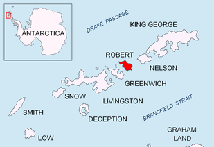
Risopatrón Base, also Luis Risopatrón Base, is a small Chilean Antarctic research base in the northwest of Robert Island in the South Shetland Islands, Antarctica situated on the isthmus linking Coppermine Peninsula to Alfatar Peninsula and bounded by Carlota Cove to the north and Coppermine Cove to the south. Established as a refuge in 1949 and opened as a base in 1954, the facility supports summer research in geology, geophysics and terrestrial biology.
Risopatrón Station | |
|---|---|
 Risopatrón Station Location of Risopatrón Station in Antarctica | |
| Coordinates: 62°22′42″S 59°42′03″W | |
| Country | |
| Location in Antarctica | Robert Island South Shetland Islands Antarctica |
| Administered by | Instituto Antártico Chileno INACH |
| Established | 1954 |
| Elevation | 40 m (130 ft) |
| Population | |
| • Total |
|
| Type | Seasonal |
| Period | Summer |
| Status | Operational |
| Website | Refugio Luis Risopatrón INACH |
The base is probably named after the Chilean geographer Luis Risopatrón (1869-1930) who compiled and published a comprehensive geographical dictionary of Chile in 1924.
Location
The base is located at 62°22′42.4″S 59°42′02.5″W which is 1.61 km southeast of Fort William, 1.63 km north-northwest of The Triplets, 11.3 km north by west of Arturo Prat Base and 8.16 km north-northeast of Maldonado Base (Bulgarian mapping in 2009.)
References
- Management Plan for Antarctic Specially Protected Area No. 112: Coppermine Peninsula, Robert Island, South Shetland Islands. Secretariat of the Antarctic Treaty.
- ASPA 112: Coppermine Peninsula, Robert Island, South Shetland Islands. Secretariat of the Antarctic Treaty.
- J. Turner and S. Pendlebury. Greenwich, Robert and Media Luna Islands, South Shetland Islands. The International Antarctic Weather Forecasting Handbook. British Antarctic Survey.
- Bases, refugios y campamentos. INACH en Antártica. (in Spanish)
Maps
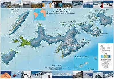
- L.L. Ivanov. Antarctica: Livingston Island and Greenwich, Robert, Snow and Smith Islands. Scale 1:120000 topographic map. Troyan: Manfred Wörner Foundation, 2010. ISBN 978-954-92032-9-5 (First edition 2009. ISBN 978-954-92032-6-4)
| General |
| .svg.png) |
|---|---|---|
| Geographic regions | ||
| Waterways | ||
| Famous explorers | ||