Pagri
Pagri[1] or Phari (Tibetan: ཕག་རི, Wylie: phag ri ; Chinese: 帕里镇; pinyin: Pàlǐ Zhèn) is a town in Yadong County[2] in the Tibet Autonomous Region, China near the border with Bhutan. As of 2004 the town had a population of 2,121.[3] It is one of the highest towns in the world, being about 4,300 m (14,100 ft) above sea-level at the head of the Chumbi Valley.[4]
Pagri Phari | |
|---|---|
Town | |
 | |
 Pagri Location in the Tibet Autonomous Region | |
| Coordinates: 27°43′06″N 89°09′18″E | |
| Country | People's Republic of China |
| Autonomous region | Tibet Autonomous Region |
| Prefecture-level city | Shigatse |
| County | Yadong |
| Population (2004) | |
| • Total | 2,121 |
| Time zone | UTC+8 (CST) |
History
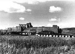
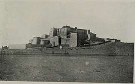
Thomas Manning, the first Englishman to reach Lhasa, visited Pagri from 21 September until 5 November 1811 and had this to say about his room in the town: "Dirt, dirt, grease, smoke. Misery, but good mutton."[5] Pagri was of some military importance in the early 20th century when it was occupied by the British Tibet Expedition under Francis Younghusband in 1904.[4] The Pagri Fortress (Dzong) was located here and was important for the government as it stood between Tibet and Bhutan. Pagri was a staging area en route to Gyantse and ultimately Lhasa.
During the summer of 1912, the 13th Dalai Lama met Agvan Dorzhiev at Phari Dzong and then accompanied him to the Samding Monastery, before returning to Lhasa after his exile in India.
Thubten Ngodup, the current Nechung Oracle, was born in Phari in 1957.
Environment
The houses are mostly made of Tibetan traditional stone and wood. The Pagri Valley lies in an alpine steppe zone on the south side, with an average annual temperature 0.1 °C (32.2 °F), and an extreme maximum temperature of 22.2 °C (72.0 °F).[3] Annual precipitation is about 380 millimetres (15 in), snow and ice melt forming rich water resources, shrubs and meadows development, a good place for the development of animal husbandry. Pagri is rich in minerals, wild animals, plants, and tourism resources. It is also a trading centre but due to geographical location is prone to natural disasters.[3] Summer flash floods, mudslides, winter avalanches, snowstorms, etc. are common, and poor facilities makes it vulnerable to disaster.[3] During the rainy season, water levels rise causing serious flooding, reducing soil quality and arable land every year, damaging the ecological environment and a threat to the inhabitants of Pagri.[3] To the northeast of Pagri is Mount Jomolhari.
Climate
Owing to its extreme altitude, Pagri has an alpine climate (Köppen ETH) that is too cold to permit the growth of trees, even though the altitude is still marginally too low for the formation of permafrost. Example Mount Fuji in Japan, Uelen in Russia and Longyearbyen in Svalbard Norway. The winter is severe in spite of the fact that no month has daytime maxima below 0 °C (32 °F), and also very dry and long, extending as late as May. Snowfall, however, is rare because of the dryness. Summers, during which the great majority of precipitation occurs, are cool even at their warmest and consistently damp, even though the Himalayas prevent falls from ever being heavy.
| Climate data for Pagri | |||||||||||||
|---|---|---|---|---|---|---|---|---|---|---|---|---|---|
| Month | Jan | Feb | Mar | Apr | May | Jun | Jul | Aug | Sep | Oct | Nov | Dec | Year |
| Record high °C (°F) | 14.7 (58.5) |
13.8 (56.8) |
15.4 (59.7) |
16.6 (61.9) |
16.5 (61.7) |
22.2 (72.0) |
21.9 (71.4) |
21.0 (69.8) |
19.9 (67.8) |
16.8 (62.2) |
16.4 (61.5) |
13.2 (55.8) |
22.2 (72.0) |
| Average high °C (°F) | 0.9 (33.6) |
1.4 (34.5) |
3.9 (39.0) |
7.0 (44.6) |
10.0 (50.0) |
12.5 (54.5) |
12.8 (55.0) |
12.7 (54.9) |
11.4 (52.5) |
8.2 (46.8) |
5.3 (41.5) |
3.2 (37.8) |
7.4 (45.4) |
| Daily mean °C (°F) | −8.7 (16.3) |
−7.1 (19.2) |
−3.7 (25.3) |
0.0 (32.0) |
3.5 (38.3) |
7.0 (44.6) |
7.9 (46.2) |
7.5 (45.5) |
5.8 (42.4) |
0.9 (33.6) |
−4.1 (24.6) |
−7.4 (18.7) |
0.1 (32.2) |
| Average low °C (°F) | −17.2 (1.0) |
−15 (5) |
−10.4 (13.3) |
−5.5 (22.1) |
−1.3 (29.7) |
3.0 (37.4) |
4.4 (39.9) |
4.0 (39.2) |
1.8 (35.2) |
−4.9 (23.2) |
−11.7 (10.9) |
−16.1 (3.0) |
−5.7 (21.7) |
| Record low °C (°F) | −28.7 (−19.7) |
−28.4 (−19.1) |
−29.8 (−21.6) |
−20.2 (−4.4) |
−12.5 (9.5) |
−5.7 (21.7) |
−1.1 (30.0) |
−2.1 (28.2) |
−6.5 (20.3) |
−21.5 (−6.7) |
−26.2 (−15.2) |
−27.4 (−17.3) |
−29.8 (−21.6) |
| Average precipitation mm (inches) | 5.0 (0.20) |
8.8 (0.35) |
21.8 (0.86) |
27.9 (1.10) |
31.0 (1.22) |
57.1 (2.25) |
104.8 (4.13) |
95.7 (3.77) |
54.2 (2.13) |
27.9 (1.10) |
4.5 (0.18) |
2.8 (0.11) |
441.5 (17.4) |
| Average precipitation days (≥ 0.1 mm) | 2.8 | 4.9 | 9.4 | 12.9 | 17.4 | 21.7 | 27.3 | 27.4 | 21.5 | 7.1 | 1.9 | 1.4 | 155.7 |
| Source: Weather China[1] | |||||||||||||
References
- 帕里城市介绍. Weather China. 2011. Retrieved on December 3, 2011.
- 2017年统计用区划代码和城乡划分代码:亚东县 (in Chinese). National Bureau of Statistics of the People's Republic of China. 2017. Retrieved 2018-11-16.
统计用区划代码 名称 540233100000 下司马镇 540233101000 帕里镇 540233200000 下亚东乡 540233201000 堆纳乡 540233202000 上亚东乡 540233203000 吉汝乡 540233204000 康布乡
- baike.baidu.com (in Chinese)
- Chisholm, Hugh, ed. (1911). . Encyclopædia Britannica. 21 (11th ed.). Cambridge University Press. p. 346.
- Markham, Clements (1876). Narratives of the Mission of George Bogle to Tibet and of the Journey of Thomas Manning to Lhasa. London: Trubner & Co., Ludgate Hill. p. 216.
| Wikimedia Commons has media related to Phari. |

| County-level divisions |
|  | ||||
|---|---|---|---|---|---|---|
| Settlements | ||||||
| Landmarks |
| |||||
| Geography | ||||||
| Transport |
| |||||