Shenton Way
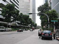
Shenton Way is a major trunk road in Singapore's Central Area, most known for the commercial skyscrapers flanking both sides of the road. The road is a one-way street that starts at the junction of Boon Tat Street, Raffles Quay and Commerce Street and ends at Keppel Road. The road is built almost entirely on reclaimed land in what was once the Telok Ayer Basin. It was originally intended to be named Raffles Way, but later Shenton Way was chosen after Sir Shenton Thomas, Governor of Singapore 1934–1946, as an acknowledgment of his decision to stay in the city during the Japanese occupation of Singapore.[1]
Shenton Way | |
|---|---|
| Name transcription(s) | |
| • Chinese | 珊顿大道 |
| • Malay | Laluan Shenton |
| • Tamil | ஷெண்டன் வே |
 | |
| Country | Singapore |
Officially opened in 1951, it became known as Singapore's Wall Street when commercial developments and government offices were built there from the 1970s onwards, and continues to be a prime commercial address on par with that of Raffles Place today.
The upcoming Shenton Way MRT station, which will be named after the nearby road, will be located on Park Street next to Asia Square.
Buildings along Shenton Way
- One Shenton Way
- AXA Tower (also known as 8 Shenton Way)
- SGX Centre
- OUE Downtown (formerly DBS Building)
- Singapore Conference Hall
- MAS Building
- Shenton House
- Eon Shenton
- 76 Shenton Way
- 78 Shenton Way
- V on Shenton (formerly UIC Building)
- Hock Teck See (望海大伯公福德祠), built in 1844
References
- "Shenton Way". Singapore Infopedia. National Library Board.
- Peter K G Dunlop (2000) Street Names of Singapore Who's Who Publishing ISBN 981-4062-11-1
Major roads and expressways of Singapore | ||
|---|---|---|
| Expressways | ||
| Semi-expressways | ||
| Major roads |
| |
| Cancelled | ||