Servas, Ain
Servas is a commune in the Ain department in eastern France.
Servas | |
|---|---|
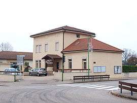 The town hall in Servas | |
.svg.png) Coat of arms | |
Location of Servas 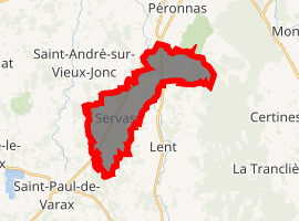
| |
 Servas  Servas | |
| Coordinates: 46°08′00″N 5°10′00″E | |
| Country | France |
| Region | Auvergne-Rhône-Alpes |
| Department | Ain |
| Arrondissement | Bourg-en-Bresse |
| Canton | Ceyzériat |
| Intercommunality | Bassin de Bourg-en-Bresse |
| Government | |
| • Mayor (2020-2026) | Serge Guérin |
| Area 1 | 13.05 km2 (5.04 sq mi) |
| Population (2017-01-01)[1] | 1,247 |
| • Density | 96/km2 (250/sq mi) |
| Time zone | UTC+01:00 (CET) |
| • Summer (DST) | UTC+02:00 (CEST) |
| INSEE/Postal code | 01405 /01960 |
| Elevation | 234–279 m (768–915 ft) |
| 1 French Land Register data, which excludes lakes, ponds, glaciers > 1 km2 (0.386 sq mi or 247 acres) and river estuaries. | |
Geography
The Veyle flows northwest through the northeastern part of the commune.
Population
| Historical population | ||
|---|---|---|
| Year | Pop. | ±% |
| 1793 | 395 | — |
| 1800 | 319 | −19.2% |
| 1806 | 386 | +21.0% |
| 1821 | 361 | −6.5% |
| 1831 | 364 | +0.8% |
| 1836 | 352 | −3.3% |
| 1841 | 375 | +6.5% |
| 1846 | 412 | +9.9% |
| 1851 | 431 | +4.6% |
| 1856 | 421 | −2.3% |
| 1861 | 428 | +1.7% |
| 1866 | 457 | +6.8% |
| 1872 | 448 | −2.0% |
| 1876 | 432 | −3.6% |
| 1881 | 426 | −1.4% |
| 1886 | 474 | +11.3% |
| 1891 | 459 | −3.2% |
| 1896 | 474 | +3.3% |
| 1901 | 432 | −8.9% |
| 1906 | 409 | −5.3% |
| 1911 | 422 | +3.2% |
| 1921 | 399 | −5.5% |
| 1926 | 392 | −1.8% |
| 1931 | 390 | −0.5% |
| 1936 | 370 | −5.1% |
| 1946 | 381 | +3.0% |
| 1954 | 383 | +0.5% |
| 1962 | 413 | +7.8% |
| 1968 | 439 | +6.3% |
| 1975 | 539 | +22.8% |
| 1982 | 818 | +51.8% |
| 1990 | 879 | +7.5% |
| 1999 | 914 | +4.0% |
| 2008 | 1,174 | +28.4% |
| 2017 | 1,247 | +6.2% |
See also
References
- "Populations légales 2017". INSEE. Retrieved 6 January 2020.
| Wikimedia Commons has media related to Servas, Ain. |
This article is issued from Wikipedia. The text is licensed under Creative Commons - Attribution - Sharealike. Additional terms may apply for the media files.