Saint-Étienne-sur-Chalaronne
Saint-Étienne-sur-Chalaronne is a commune in the Ain department in eastern France.
Saint-Étienne-sur-Chalaronne | |
|---|---|
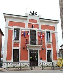 The town hall in Saint-Étienne-sur-Chalaronne | |
Location of Saint-Étienne-sur-Chalaronne 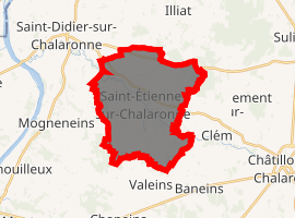
| |
 Saint-Étienne-sur-Chalaronne  Saint-Étienne-sur-Chalaronne | |
| Coordinates: 46°09′N 4°52′E | |
| Country | France |
| Region | Auvergne-Rhône-Alpes |
| Department | Ain |
| Arrondissement | Bourg-en-Bresse |
| Canton | Châtillon-sur-Chalaronne |
| Intercommunality | Val-de-Saône Chalaronne |
| Government | |
| • Mayor (2008–2014) | Serge Varvier |
| Area 1 | 20.99 km2 (8.10 sq mi) |
| Population (2017-01-01)[1] | 1,555 |
| • Density | 74/km2 (190/sq mi) |
| Time zone | UTC+01:00 (CET) |
| • Summer (DST) | UTC+02:00 (CEST) |
| INSEE/Postal code | 01351 /01140 |
| Elevation | 183–261 m (600–856 ft) (avg. 217 m or 712 ft) |
| 1 French Land Register data, which excludes lakes, ponds, glaciers > 1 km2 (0.386 sq mi or 247 acres) and river estuaries. | |
Geography
The Chalaronne flows northwest through the middle of the commune and crosses the village.
Population
| Historical population | ||
|---|---|---|
| Year | Pop. | ±% |
| 1793 | 1,196 | — |
| 1800 | 1,294 | +8.2% |
| 1806 | 1,294 | +0.0% |
| 1821 | 1,439 | +11.2% |
| 1831 | 1,484 | +3.1% |
| 1836 | 1,606 | +8.2% |
| 1841 | 1,615 | +0.6% |
| 1846 | 1,601 | −0.9% |
| 1851 | 1,639 | +2.4% |
| 1856 | 1,627 | −0.7% |
| 1861 | 1,557 | −4.3% |
| 1866 | 1,545 | −0.8% |
| 1872 | 1,460 | −5.5% |
| 1876 | 1,468 | +0.5% |
| 1881 | 1,411 | −3.9% |
| 1886 | 1,343 | −4.8% |
| 1891 | 1,360 | +1.3% |
| 1896 | 1,346 | −1.0% |
| 1901 | 1,244 | −7.6% |
| 1906 | 1,213 | −2.5% |
| 1911 | 1,206 | −0.6% |
| 1921 | 1,108 | −8.1% |
| 1926 | 1,034 | −6.7% |
| 1931 | 990 | −4.3% |
| 1936 | 967 | −2.3% |
| 1946 | 938 | −3.0% |
| 1954 | 917 | −2.2% |
| 1962 | 863 | −5.9% |
| 1968 | 878 | +1.7% |
| 1975 | 828 | −5.7% |
| 1982 | 808 | −2.4% |
| 1990 | 1,037 | +28.3% |
| 1999 | 1,179 | +13.7% |
| 2008 | 1,415 | +20.0% |
See also
External links
| Wikimedia Commons has media related to Saint-Étienne-sur-Chalaronne. |
This article is issued from Wikipedia. The text is licensed under Creative Commons - Attribution - Sharealike. Additional terms may apply for the media files.