Innimond
Innimond is a commune in the Ain department in eastern France.
Innimond | |
|---|---|
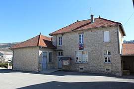 The town hall in Innimond | |
Location of Innimond 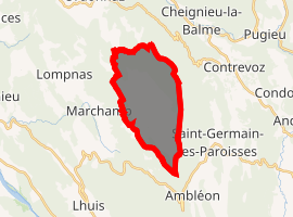
| |
 Innimond  Innimond | |
| Coordinates: 45°46′58″N 5°34′20″E | |
| Country | France |
| Region | Auvergne-Rhône-Alpes |
| Department | Ain |
| Arrondissement | Belley |
| Canton | Lagnieu |
| Intercommunality | Rhône Chartreuse de Portes |
| Government | |
| • Mayor (2008–2014) | Eric Nodet |
| Area 1 | 13.44 km2 (5.19 sq mi) |
| Population (2017-01-01)[1] | 89 |
| • Density | 6.6/km2 (17/sq mi) |
| Time zone | UTC+01:00 (CET) |
| • Summer (DST) | UTC+02:00 (CEST) |
| INSEE/Postal code | 01190 /01680 |
| Elevation | 811–1,218 m (2,661–3,996 ft) (avg. 900 m or 3,000 ft) |
| 1 French Land Register data, which excludes lakes, ponds, glaciers > 1 km2 (0.386 sq mi or 247 acres) and river estuaries. | |
Population
| Historical population | ||
|---|---|---|
| Year | Pop. | ±% |
| 1793 | 459 | — |
| 1800 | 432 | −5.9% |
| 1806 | 432 | +0.0% |
| 1821 | 331 | −23.4% |
| 1831 | 380 | +14.8% |
| 1836 | 368 | −3.2% |
| 1841 | 371 | +0.8% |
| 1846 | 411 | +10.8% |
| 1851 | 405 | −1.5% |
| 1856 | 408 | +0.7% |
| 1861 | 367 | −10.0% |
| 1866 | 378 | +3.0% |
| 1872 | 364 | −3.7% |
| 1876 | 359 | −1.4% |
| 1881 | 354 | −1.4% |
| 1886 | 383 | +8.2% |
| 1891 | 352 | −8.1% |
| 1896 | 367 | +4.3% |
| 1901 | 367 | +0.0% |
| 1906 | 360 | −1.9% |
| 1911 | 330 | −8.3% |
| 1921 | 301 | −8.8% |
| 1926 | 287 | −4.7% |
| 1931 | 264 | −8.0% |
| 1936 | 231 | −12.5% |
| 1946 | 210 | −9.1% |
| 1954 | 189 | −10.0% |
| 1962 | 188 | −0.5% |
| 1968 | 143 | −23.9% |
| 1975 | 98 | −31.5% |
| 1982 | 82 | −16.3% |
| 1990 | 81 | −1.2% |
| 1999 | 95 | +17.3% |
| 2008 | 111 | +16.8% |
See also
External links
| Wikimedia Commons has media related to Innimond. |
This article is issued from Wikipedia. The text is licensed under Creative Commons - Attribution - Sharealike. Additional terms may apply for the media files.