Rome Metro
The Rome Metro (Italian: Metropolitana di Roma) is a rapid transit system that operates in Rome, Italy. It started operation in 1955, making it the oldest in the country.
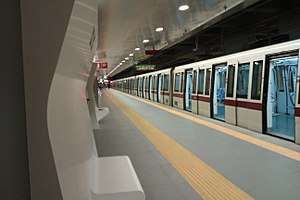 A S300 train at Conca d'Oro station | |||
| Overview | |||
|---|---|---|---|
| Native name | Metropolitana di Roma | ||
| Locale | Rome, Italy | ||
| Transit type | Rapid transit | ||
| Number of lines | 3[1] | ||
| Number of stations | 73[1][2][Note 1] | ||
| Annual ridership | 279 million (2012)[1] | ||
| Website | ATAC S.p.A. | ||
| Operation | |||
| Began operation | 9 February 1955 | ||
| Operator(s) | ATAC | ||
| Number of vehicles | 83 trains[1] | ||
| Technical | |||
| System length | 60.0 km (37.3 mi)[1][2][3] | ||
| Track gauge | 1,435 mm (4 ft 8 1⁄2 in) (standard gauge) | ||
| Electrification | Overhead lines | ||
| |||
.png)
The Metro comprises three lines – A (orange), B (blue) and C (green) – which operate on 60 km (37 mi) of route, serving 73 stations.[1][2][Note 1] The original lines in the system, lines A and B, form an X shape with the lines intersecting at Termini station, the main train station in Rome. Line B splits at the Bologna station into two branches. The third line opened in 2014 and connects to the rest of the system through an interchange with Line A at San Giovanni.
Rome's local transport provider, ATAC, operates the Metro and several other rail services: the Roma–Lido line, the Roma-Giardinetti line, and the Roma–Nord line. The first of these, the Roma–Lido, which connects Rome to Ostia, on the sea, is effectively part of the metro network. It is run on similar lines and uses trains similar to those in service on the Metro.
Lines
| Line | Termini | Opened | Newest extension |
Length | Stations | ||
|---|---|---|---|---|---|---|---|
| km | mi | ||||||
| Battistini | Anagnina | 1980 | 2000 | 18.4 | 11.4 | 27 | |
| Laurentina | Rebibbia / Jonio | 1955 | 2015 | 22.9 | 14.2 | 26 | |
| Monte Compatri-Pantano | San Giovanni | 2014 | 2018 | 19.1 | 11.9 | 22 | |
Line A
Line A runs from the southeastern suburbs of Rome, then along the northeast section of downtown, and then to the northern section of the city, near Vatican City. It connects with Line B, along with many other national and regional rail services, at Termini, and with Line C at San Giovanni. It has 27 stations, with terminals at Battistini and Anagnina. It is identified by the colour orange.
Line A was the second line built in Rome. Approval was given for the construction of the city's second metro line in 1959.
Work on Line A began in 1964 in the Tuscolana area, but suffered a series of delays caused by poor organisation. Above all, the originally planned method of construction, the cut and cover, posed serious problems for road traffic in south-east Rome. Work on the Metro was suspended and began again five years later, using bored tunnels, which partially resolved the traffic problems but caused numerous claims for compensation for vibrations caused by the machines. Work was also frequently interrupted by archaeological finds made during the excavations, particularly near Piazza della Repubblica.
Line A entered service in February 1980. In the late 1990s it was extended from Ottaviano, in the Prati district, to Battistini to the west.
Line B
Line B was the first Metro line in Rome. Line B connects the north-east of the city with the south-west. It has 26 stations with terminals at Rebibbia, Jonio and Laurentina (just east of EUR). It is identified by the colour blue. Transfers are available with Line A and other rail services at Termini Station.
Line B was planned during the 1930s by the fascist government to provide a rapid connection between the main train station, Termini, and a new district to the south-east of the city, E42, the planned location of the Universal Exposition (or Expo), which was to be held in Rome in 1942. The exposition never took place due to Italy's entry into the Second World War in 1940. When its construction was interrupted, some of the tunnels on the city-centre side of the Metro (between Termini and Piramide) had already been completed, and they were used as air raid shelters during the war.
Work restarted in 1948, together with the development of the site formerly designated for the Expo into a residential and business district under the name EUR. The metro was officially opened on 9 February 1955 by the then President of the Republic Luigi Einaudi. Regular services began the following day.
In 1990, Line B was extended from Termini to Rebibbia in the east of the city and the entire line was modernised. A new 4 km (2.5 mi) long branch (B1) was opened connecting Piazza Bologna with Conca d'Oro on 13 June 2012; the branch's last stop (and new terminus), Jonio, was opened on 21 April 2015.
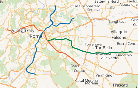
Line C

Opened on 9 November 2014, line C currently runs radially from San Giovanni, serving as an interchange station for Line A, to the eastern terminus of Pantano (the former terminus of the Roma-Giardinetti light railway). It is the first Metro line to extend beyond the city boundaries in Rome.
It is planned to extend to the northwest, towards Grottarossa (north of the Vatican), via the city centre; it will also intersect with Line A at Ottaviano (beside the Vatican), with Line B at Colosseo, and with the planned Line D at piazza Venezia, thus creating a fourth metro hub in Rome.
_2.jpg)
The first section of the line, from Centocelle to Pantano,[4] is the furthest from the city centre and includes 15 of the planned 30 stops. A further 5.4-kilometre (3.4 mi) section of Line C, serving six additional stations, opened on 29 June 2015, as the line's western terminus was moved from Parco di Centocelle to Lodi.[2] On 12 May 2018, the western terminus was moved to San Giovanni (interchange station for line A).[5] After this third phase, the line will be further extended with two stations, Amba Aradam/Ipponio and Fori Imperiali/Colosseo, located in the city centre.[6] A further extension to Piazza Venezia was announced by Mayor Virginia Raggi in July 2019.[7]
Progress on the line has been slow with projected completion dates being repeatedly delayed. Rome is one of the oldest cities in the world and the construction of the Metro system has encountered considerable obstacles owing to the frequent archaeological discoveries.[8] While the excavation of the tunnels themselves can be undertaken well below the probable location of most archaeological finds, the excavation of stairwells and ventilation shafts - which must, by necessity, connect with the surface - pose considerable difficulties.
The trains operating on line C are completely automated,[9] and use the same AnsaldoBreda Driverless Metro system also featured on the Copenhagen Metro.
Archeostation
During the excavation for the central route of line C, thanks to the archeological richness of Rome's ground a new type of underground station was born, as in Paris with Louvre-Rivoli station.
San Giovanni
San Giovanni station was the first archeostation to be opened on 12 May 2018. Excavation to a depth of about 20m. allowed the exploration of about 21 stratifications of history up to the so-called virgin soil, the one in which man's presence is absent.
The exhibition is characterized by being a real tour with libraries for the finds along the route, explanatory panels on the walls and a temporal measurement of the historical phases that follows the path of the passengers from the atrium level to the platforms' level:
- Atrium level: from Contemporary Age to Late Antiquity Age
- First underground level: from Republican Age to Archaic Age
- Platform level: Prehistoric Age
The various archaeological finds and exhibits include small items such as gold jewellery, coins, crockery, shells, large amphorae and elements of ancient columns and also large finds, such as the large pool, the largest reservoir ever found, located inside a farm of the imperial age.
Timeline
| date | section or station | line |
|---|---|---|
| 10 February 1955 | Termini - EUR Fermi | |
| 16 February 1980 | Ottaviano - Cinecittà | |
| 11 June 1980 | Cinecittà - Anagnina | |
| 8 December 1990 | Termini - Rebibbia Garbatella Laurentina | |
| 12 March 1993 | Marconi | |
| 13 December 1995 | Ponte Mammolo | |
| 29 May 1999 | Ottaviano - Valle Aurelia | |
| 1 January 2000 | Valle Aurelia - Battistini | |
| 23 June 2003 | Quintiliani | |
| 12 June 2012 | Bologna - Conca d'Oro | |
| 9 November 2014 | Monte Compatri-Pantano - Parco di Centocelle | |
| 21 April 2015 | Conca d'Oro - Jonio | |
| 29 June 2015 | Parco di Centocelle - Lodi | |
| 12 May 2018 | Lodi - San Giovanni |
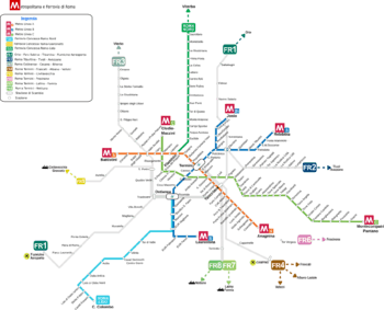
Network map
Service
Fares
An urban single journey ticket, the Biglietto Integrato a Tempo (BIT), costs €1.50, and is valid on the Metro, buses, trams and suburban trains inside the Rome municipality. Other tickets are available, including daily, 2-day, and 3-day passes (Rome 24h/48h/72h), and a weekly pass, the Carta Integrata Settimanale (CIS).
Two proximity cards are available in Rome, èRoma and Metrebus Card Red, which can be charged with season tickets, replacing paper for this type of ticket.
Operating hours
Service starts at about 5:30 am and ends at about 11:30 pm. On Fridays and Saturdays service ends later, at about 1:30 am.[10]
When the Metro is closed, a night bus service operates with lines that follow the same routes and stop at the same stations as the Metro. Line A is served by bus NMA, Line B is served by bus NMB/NMB1, and Line C is served by bus N28.
Other rail lines operated by ATAC

Roma–Lido
Construction of the Roma–Lido line began shortly after the end of World War I and was completed some six years later in 1924. It began operation as a steam locomotion railway but electrification was completed less than a year later.
The line is operated as an integrated part of the Metro, but runs entirely overground. It runs from the Roma Porta San Paolo station beside the Line B Piramide station and runs alongside Line B as far as EUR Magliana. It then continues separately on to the seaside district of Ostia. The line terminates beside the end of Via Cristoforo Colombo.
Roma–Giardinetti

Officially termed a railway, the Roma–Giardinetti line is a narrow gauge tram which connects Laziali (a smaller, local train station some 800 metres east of Temini's main concourse) with Giardinetti, just past the Grande Raccordo Anulare (GRA) - Rome's orbital motorway. The line originally ran to Frosinone some 137 km (85 mi) from Rome, but has been gradually reduced in length, when the section from Giardinetti to Pantano, which will become a permanent part of Line C, was taken out of service. Most recently also the part from Centocelle to Giardinetti was reduced.
Roma–Civitacastellana–Viterbo
.jpeg)
The Roma–Civitacastellana–Viterbo line (also called Roma Nord railway) began life as a narrow-gauge tram running from Piazza della Libertà in Rome to Civita Castellana. However the next stretch of the line, to Viterbo, was built as a railway and over the years the tram section was converted into a railway as well, a process which concluded with the moving of the Roman terminus from the street-level terminus at Piazza della Libertà across the river to a new underground station in Piazzale Flaminio, beside the subsequently constructed Line A station, after World War II.
The line is operated in two modes: as an urban service from Piazzale Flaminio to Montebello, and as a suburban service from Piazzale Flaminio to Viterbo. The urban service operates with a frequency of about one train every ten minutes, while the suburban service operates considerably less frequently, with less than a third of the trains making the full two and a half hour journey from Rome to Viterbo.
Future expansions
The metro system is currently expanding:
- An extension of line A from Battistini to Torrevecchia towards the west of the city is planned; a track of 2 kilometres (1.2 mi) with 2 stations.[11]
- An extension of line B is planned too. A track of 2.8 kilometres (1.7 mi) with 2 stations should be realized from Rebibbia (Rome Metro) to Torraccia/Casal Monastero, towards the east of Rome.
- The extension of line C towards the centre of Rome is under construction. From San Giovanni (interchange station with line A) to Colosseo (to interchange with the line B), the track is 3.6 kilometres (2.2 mi) long with an intermediate station near San Giovanni Addolorata Hospital, Amba Aradam.
New lines
There are two proposed new lines. There are no timelines yet for their construction. Line D would be a completely new line linking Ojetti and Agricoltura; while alone E would see the existing Rome–Lido railway extended from its Porta S. Paolo terminus to Jonio using the existing Line B infrastructure.[12] Future other line G : Termini- A1 casello Torrenova 19 km
| Line | Terminals | Opening | Length | Stations | ||||||||||||||||||||||||||||||||||||||||||||||||||||||||||||||||||||||||||||||||||||||||||
|---|---|---|---|---|---|---|---|---|---|---|---|---|---|---|---|---|---|---|---|---|---|---|---|---|---|---|---|---|---|---|---|---|---|---|---|---|---|---|---|---|---|---|---|---|---|---|---|---|---|---|---|---|---|---|---|---|---|---|---|---|---|---|---|---|---|---|---|---|---|---|---|---|---|---|---|---|---|---|---|---|---|---|---|---|---|---|---|---|---|---|---|---|---|---|
| Ojetti | Agricoltura | 22 km | 22 | |||||||||||||||||||||||||||||||||||||||||||||||||||||||||||||||||||||||||||||||||||||||||||
| Cristoforo Colombo | Jonio | 38 km | 25 |
Signalling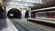 Signalling at the Marconi station Signalling of the Rome Metro guarantees a safe and correct trains' circulation in the three metro lines of the Italian capital city. Line ALine A uses an evolution of the RS4 Codici, a classical block system of the Italian railway. Since its creation the signalling offers to the conductor advice about the speed limit and the freedom of the way.[13] Line BUntil 1990 line B used a railway-like signalling system that advised only about the freedom of the way.[14] Since 1990 the line uses a new signalling, inspired by the Milan Metro's signalling, that gives information about the speed limit in the section within a range of 0 km/h and 80 km/h. Conductors are informed by classical light semaphores.[15] Line CLine C is an automatic metro line and uses a radio frequency system for communication with the train and has an electrical based block system that permit a max frequency of a train every 90 seconds.[16] See also
Notes
References
External links
| ||||||||||||||||||||||||||||||||||||||||||||||||||||||||||||||||||||||||||||||||||||||||||
