Roche Bonhomme
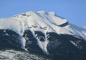
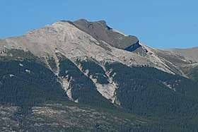
Roche Bonhomme is a 2,500-metre (8,200-foot) mountain summit located in Jasper National Park in Alberta, Canada. It is located in the Colin Range, which is a sub-range of the Canadian Rockies.[3] [2] The peak is situated 13 km (8.1 mi) northeast of the municipality of Jasper, and is a prominent landmark in the Athabasca Valley visible from Highway 16 and the Canadian. Its nearest higher peak is Grisette Mountain, 2.2 km (1.4 mi) to the east.[1] Roche Bonhomme was named in 1878 by George Munro Grant for the fact it has an anthropomorphic shape.[4] The French "Roche Bonhomme" translates to "Rock Fellow." The mountain's name was officially adopted in 1947 by the Geographical Names Board of Canada.[2] Roche Bonhomme is composed of Permian and Carboniferous strata topped by darker Triassic siltstone of the Sulphur Mountain Formation.[5]
| Roche Bonhomme | |
|---|---|
 Roche Bonhomme | |
| Highest point | |
| Elevation | 2,500 m (8,200 ft) [1]> |
| Prominence | 160 m (520 ft) [1] |
| Coordinates | 52°56′41″N 117°56′36″W [2] |
| Geography | |
 Roche Bonhomme Location of Roche Bonhomme in Alberta  Roche Bonhomme Roche Bonhomme (Canada) | |
| Location | Jasper National Park Alberta, Canada |
| Parent range | Colin Range Canadian Rockies |
| Topo map | NTS 83C/13 |
| Geology | |
| Type of rock | sedimentary rock |
Climate
Based on the Köppen climate classification, Roche Bonhomme is located in a subarctic climate with cold, snowy winters, and mild summers.[6] Temperatures can drop below -20 °C with wind chill factors below -30 °C. In terms of favorable weather, June through September are the best months to climb. Precipitation runoff from Roche Bonhomme flows into tributaries of the Maligne River which in turn is a tributary of the Athabasca River.
See also
- Mountains of Alberta
- Geography of Alberta
References
- "Roche Bonhomme". Bivouac.com. Retrieved 2019-03-08.
- "Roche Bonhomme". Geographical Names Data Base. Natural Resources Canada. Retrieved 2019-03-08.
- "Roche Bonhomme, Alberta". Peakbagger.com.
- Place-names of Alberta. Ottawa: Geographic Board of Canada. 1928. p. 22.
- Roche BonhommePeakFinder
- Peel, M. C.; Finlayson, B. L. & McMahon, T. A. (2007). "Updated world map of the Köppen−Geiger climate classification". Hydrol. Earth Syst. Sci. 11: 1633–1644. ISSN 1027-5606.
External links
- Parks Canada web site: Jasper National Park