RM postcode area
The RM postcode area, also known as the Romford postcode area,[2] is a group of twenty postcode districts in England, within nine post towns. These cover parts of east London, most of the London Borough of Havering and south-west Essex. Inward mail for the area is sorted, along with mail for the E and IG postcode areas, at the Romford Mail Centre.
| Romford postcode area | |
|---|---|
 RM | |
| Postcode area | RM |
| Postcode area name | Romford |
| Post towns | 9 |
| Postcode districts | 21 |
| Postcode sectors | 71 |
| Postcodes (live) | 9,753 |
| Postcodes (total) | 14,323 |
| Statistics as at February 2012[1] | |
The area served includes most of the London Borough of Havering, the eastern part of the London Borough of Barking and Dagenham and a small part of the London Borough of Redbridge. In Essex, the area covers most of the Thurrock unitary district, while RM4 covers small parts of the Epping Forest District and the Borough of Brentwood.
Coverage
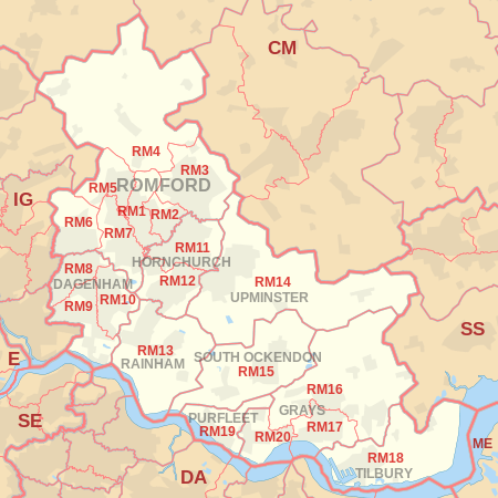
The approximate coverage of the postcode districts:
| Postcode district | Post town | Coverage | Local authority area |
|---|---|---|---|
| RM1 | ROMFORD | Romford, Rise Park | Havering |
| RM2 | ROMFORD | Gidea Park, Heath Park | Havering |
| RM3 | ROMFORD | Harold Wood, Harold Hill, Noak Hill, Harold Park | Havering |
| RM4 | ROMFORD | Havering-atte-Bower, Abridge, Stapleford Abbotts, Noak Hill, Navestock, Stapleford Tawney, Stapleford Aerodrome, Passingford Bridge | Havering, Epping Forest, Brentwood |
| RM5 | ROMFORD | Collier Row | Havering, Redbridge |
| RM6 | ROMFORD | Chadwell Heath, Marks Gate, Little Heath, Goodmayes (north), Hainault (South) | Barking and Dagenham, Redbridge, Havering |
| RM7 | ROMFORD | Rush Green, Mawneys, Romford | Havering |
| RM8 | DAGENHAM | Dagenham, Becontree, Becontree Heath, Chadwell Heath (south) | Barking and Dagenham, Redbridge |
| RM9 | DAGENHAM | Dagenham, Becontree Castle Green | Barking and Dagenham, Redbridge, Havering |
| RM10 | DAGENHAM | Dagenham, Becontree | Barking and Dagenham |
| RM11 | HORNCHURCH | Hornchurch, Emerson Park, Ardleigh Green | Havering |
| RM12 | HORNCHURCH | Hornchurch, Elm Park | Havering |
| RM13 | RAINHAM | Rainham, South Hornchurch, Wennington | Havering |
| RM14 | UPMINSTER | Upminster, Cranham, North Ockendon, Bulphan | Havering, Thurrock |
| RM15 | SOUTH OCKENDON | South Ockendon, Aveley | Thurrock, Havering |
| RM16 | GRAYS | Chafford Hundred, Chadwell St Mary, North Stifford, Orsett | Thurrock |
| RM17 | GRAYS | Grays, Badgers Dene | Thurrock |
| RM18 | TILBURY | Tilbury, East Tilbury, West Tilbury | Thurrock |
| RM19 | PURFLEET | Purfleet | Thurrock |
| RM20 | GRAYS | West Thurrock, South Stifford, Lakeside Shopping Centre | Thurrock |
Map
References
- "ONS Postcode Directory Version Notes" (ZIP). National Statistics Postcode Products. Office for National Statistics. February 2012. Table 2. Retrieved 21 April 2012. Coordinates from mean of unit postcode points, "Code-Point Open". OS OpenData. Ordnance Survey. February 2012. Retrieved 21 April 2012.
- Royal Mail, Address Management Guide, (2004)
External links
This article is issued from Wikipedia. The text is licensed under Creative Commons - Attribution - Sharealike. Additional terms may apply for the media files.