BR postcode area
The BR postcode area, also known as the Bromley postcode area,[2] is a group of eight postcode districts in England, within seven post towns. These cover part of south-eastern Greater London, as well as a small part of north-west Kent.
| Bromley postcode area | |
|---|---|
 BR | |
| Postcode area | BR |
| Postcode area name | Bromley |
| Post towns | 7 |
| Postcode districts | 9 |
| Postcode sectors | 39 |
| Postcodes (live) | 7,009 |
| Postcodes (total) | 10,137 |
| Statistics as at February 2012[1] | |
The area covers much of the London Borough of Bromley, as well as small parts of the London Borough of Lewisham, the Royal Borough of Greenwich and the London Borough of Croydon. Most of BR8 and a small part of BR6 cover the northwestern part of the Sevenoaks District of Kent, while BR8 also covers the hamlet of Clement Street in the borough of Dartford.
Mail for the area was sorted in Bromley until 1988, when this site was converted to a delivery office only.
Coverage
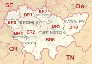
The approximate coverage of the postcode districts:
| Postcode district | Post town | Coverage | Local authority area |
|---|---|---|---|
| BR1 | BROMLEY | Bromley, Bickley, Downham, Sundridge | Bromley, Lewisham |
| BR2 | BROMLEY | Hayes, Shortlands, Bickley, Bromley Common | Bromley |
| KESTON | Keston, Leaves Green | ||
| BR3 | BECKENHAM | Beckenham, Elmers End, Shortlands, Eden Park, Park Langley | Bromley, Lewisham, Croydon |
| BR4 | WEST WICKHAM | West Wickham | Bromley |
| BR5 | ORPINGTON | Petts Wood, St Mary Cray, St Paul's Cray, Ruxley | Bromley |
| BR6 | ORPINGTON | Orpington, Locksbottom, Farnborough, Green Street Green, Chelsfield, Downe, Pratt's Bottom, Well Hill | Bromley, Sevenoaks |
| BR7 | CHISLEHURST | Chislehurst, Elmstead | Bromley, Greenwich |
| BR8 | SWANLEY | Swanley, Hextable, Crockenhill, Swanley Village, Hockenden | Sevenoaks, Bromley, Dartford |
Map
References
- "ONS Postcode Directory Version Notes" (ZIP). National Statistics Postcode Products. Office for National Statistics. February 2012. Table 2. Retrieved 21 April 2012. Coordinates from mean of unit postcode points, "Code-Point Open". OS OpenData. Ordnance Survey. February 2012. Retrieved 21 April 2012.
- Royal Mail, Address Management Guide, (2004)
External links
This article is issued from Wikipedia. The text is licensed under Creative Commons - Attribution - Sharealike. Additional terms may apply for the media files.