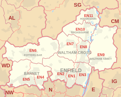
EN postcode area
The EN postcode area, also known as the Enfield postcode area,[2] is a group of eleven postcode districts in England, within seven post towns. These cover parts of northern Greater London (including Enfield and Barnet), southern Hertfordshire (including Potters Bar, Waltham Cross, Broxbourne and Hoddesdon) and western Essex (including Waltham Abbey).
| Enfield postcode area | |
|---|---|
 EN | |
| Postcode area | EN |
| Postcode area name | Enfield |
| Post towns | 7 |
| Postcode districts | 12 |
| Postcode sectors | 48 |
| Postcodes (live) | 8,661 |
| Postcodes (total) | 12,445 |
| Statistics as at February 2012[1] | |
Postal administration
Mail for this area is sorted at the Home Counties North Mail Centre in Hemel Hempstead, and is delivered from offices in Enfield (Southbury Road EN1), Barnet (Longmore Avenue EN5), Potters Bar (Darkes Lane EN6), Waltham Cross (Eleanor Cross Road EN8) and Hoddesdon (Conduit Lane EN11). The area served includes the northern parts of the London Boroughs of Enfield and Barnet, the eastern part of the Hertsmere district of Hertfordshire, the southern part of the Welwyn Hatfield district and virtually all of the borough of Broxbourne, while EN9 and small parts of EN10 and EN11 cover the western part of the Epping Forest district of Essex.
List of postcode districts
The approximate coverage of the postcode districts:
| Postcode district | Post town | Coverage | Local authority area |
|---|---|---|---|
| EN1 | ENFIELD | Bush Hill Park; eastern parts of Bulls Cross, Enfield Town, Forty Hill, outskirts of Lower Edmonton | Enfield |
| EN2 | ENFIELD | Botany Bay, Clay Hill, Crews Hill; western parts of Bulls Cross, Enfield Chase, Enfield Town, Forty Hill, Gordon Hill | Enfield |
| EN3 | ENFIELD | Enfield Highway, Enfield Island Village, Enfield Lock, Enfield Wash, Ponders End | Enfield |
| EN4 | BARNET | Hadley Wood, Cockfosters, East Barnet, New Barnet | Barnet, Enfield |
| EN5 | BARNET | High Barnet, Arkley | Barnet, Hertsmere |
| EN6 | POTTERS BAR | Potters Bar, South Mimms, Cuffley, Northaw | Hertsmere, Welwyn Hatfield |
| EN7 | WALTHAM CROSS | Cheshunt, Goffs Oak, Capel Manor College | Broxbourne, Enfield |
| EN8 | WALTHAM CROSS | Waltham Cross, Cheshunt, Bullsmoor | Broxbourne, Enfield |
| EN9 | WALTHAM ABBEY | Waltham Abbey, Nazeing, Upshire | Epping Forest |
| EN10 | BROXBOURNE | Broxbourne, Wormley, Turnford | Broxbourne, Epping Forest |
| EN11 | HODDESDON | Hoddesdon, Dobbs Weir | Broxbourne, Epping Forest |
Map
See also
- Edmonton Hundred, this obsolete division has a map showing its parishes, the largest of which was always Enfield alike to the ENFIELD post town, and its bulk mirrors EN1 to EN3 and EN6
- Postcode Address File
- List of postcode areas in the United Kingdom
References
- "ONS Postcode Directory Version Notes" (ZIP). National Statistics Postcode Products. Office for National Statistics. February 2012. Table 2. Retrieved 21 April 2012. Coordinates from mean of unit postcode points, "Code-Point Open". OS OpenData. Ordnance Survey. February 2012. Retrieved 21 April 2012.
- Royal Mail, Address Management Guide, (2004)