DD postcode area
The DD postcode area, also known as the Dundee postcode area,[2] is a group of eleven postcode districts in eastern Scotland, within nine post towns. These cover Dundee and Angus (including Forfar, Arbroath, Brechin, Carnoustie, Kirriemuir and Montrose), plus part of north-east Fife (including Newport-on-Tay and Tayport) and small parts of Perth and Kinross and Aberdeenshire.
| Dundee postcode area | |
|---|---|
 DD | |
| Postcode area | DD |
| Postcode area name | Dundee |
| Post towns | 9 |
| Postcode districts | 11 |
| Postcode sectors | 52 |
| Postcodes (live) | 8,888 |
| Postcodes (total) | 10,980 |
| Statistics as at February 2012[1] | |
Coverage
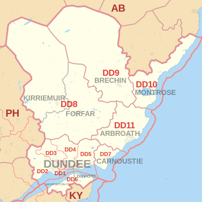
The approximate coverage of the postcode districts:
| Postcode district | Post town | Coverage | Local authority area |
|---|---|---|---|
| DD1 | DUNDEE | Most of the city centre, the University and the Riverside | Dundee |
| DD2 | DUNDEE | The West of the city including Lochee, Blackness, Ninewells, Menzieshill, Charleston, Balgay, Ardler and Logie | Dundee, Perth and Kinross |
| DD3 | DUNDEE | The northwest of the city including St Marys, Downfield and Kirkton, and the inner city areas of Strathmartine, Coldside and the Hilltown | Dundee, Angus |
| DD4 | DUNDEE | The inner city area of Stobswell and Craigie, and the northeast of the city including Pitkerro, Douglas, Fintry and Whitfield | Dundee, Angus |
| DD5 | DUNDEE | The east of the city including Broughty Ferry, Barnhill and Monifieth | Dundee, Angus |
| DD6 | NEWPORT-ON-TAY | Newport-on-Tay, Wormit, Balmerino, Gauldry | Fife |
| TAYPORT | Tayport | ||
| DD7 | CARNOUSTIE | Carnoustie | Angus |
| DD8 | FORFAR | Forfar, Glamis | Angus |
| KIRRIEMUIR | Kirriemuir | ||
| DD9 | BRECHIN | Brechin, Edzell | Angus |
| DD10 | MONTROSE | Montrose, St Cyrus, Inverbervie, Hillside, Gourdon | Angus, Aberdeenshire |
| DD11 | ARBROATH | Arbroath, Friockheim | Angus |
Map
References
- "ONS Postcode Directory Version Notes" (ZIP). National Statistics Postcode Products. Office for National Statistics. February 2012. Table 2. Retrieved 21 April 2012. Coordinates from mean of unit postcode points, "Code-Point Open". OS OpenData. Ordnance Survey. February 2012. Retrieved 21 April 2012.
- Royal Mail, Address Management Guide, (2004)
External links
This article is issued from Wikipedia. The text is licensed under Creative Commons - Attribution - Sharealike. Additional terms may apply for the media files.