Port Hardy
Port Hardy is a district municipality in British Columbia, Canada located on the northeastern end of Vancouver Island.[3] Port Hardy has a population of 4,132 at the last census (2016).
Port Hardy | |
|---|---|
| District of Port Hardy[1] | |
 Harbour of Port Hardy | |
 Port Hardy | |
| Coordinates: 50°43′21″N 127°29′34″W | |
| Country | |
| Province | |
| Region | North-Island |
| Regional District | Mount Waddington |
| Founded | 1966 |
| Government | |
| • Mayor | Dennis Dugas [2] |
| Area | |
| • Total | 38.73 km2 (14.95 sq mi) |
| Elevation | 23 m (75 ft) |
| Population (2016) | |
| • Total | 4,132 |
| • Density | 110/km2 (280/sq mi) |
| Time zone | UTC−8 (PST) |
| Postal code | V0N |
| Area code(s) | 250, 778 |
| Climate | Cfb |
| Website | http://porthardy.ca/ |
It is the gateway to Cape Scott Provincial Park, the North Coast Trail and the BC Marine Trail, located on the northernmost tip of Vancouver Island. The community has access to spectacular wilderness adventures, such as kayaking, caving, world-class scuba diving, nature viewing, surfing, unique saltwater rapids,[4] fishing and camping.
Naming
Port Hardy was named after Vice-Admiral Sir Thomas Masterman Hardy who served as the captain of H.M.S. Victory.[3] He served at the Battle of Trafalgar when Nelson died in his arms.[5]:105
Filomi Days
Once a year, Port Hardy holds a celebration in Rotary Park to acknowledge its natural resource based economy. The three syllables, fi, lo and mi, stand for "fishing, logging and mining". The celebration includes festivities in the park such as activities for children, fundraising concessions, entertainment, beer gardens, bake sales, craft sales, and fireworks. A dance for each age group and a parade are also held on Filomi Days weekend- typically the third weekend in July. Brookes Laidlaw represents the current Vice Admiral in the annual parade.
Tourism
Port Hardy's economy relies greatly on tourism. Ferries to Prince Rupert, another popular tourist destination in British Columbia, depart every other day during peak season.
Tourist traffic in the summer is immense, and hotels and restaurants usually find themselves with no room to accommodate all travellers.
Wildlife
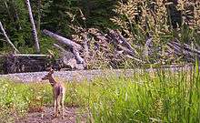
Deer, black bears, bald eagles, squirrels, seals, salmon and many other species of birds and mammals are often spotted along the Quatse Loop Nature Trail or at Storey's Beach which is a short drive from town. Humpback whales can occasionally been seen surfacing in the bay. Port Hardy has many wildlife charters, fishing charters and places to camp during tourist season.
Climate
Port Hardy has an oceanic climate (Köppen Cfb) due to its proximity to the Pacific moderating influence. As a result, summers are very cool for the latitude, whereas winters instead are very mild. Although there is a strong drying trend in summer, its summer rainfall is still higher than those of the southerly mediterranean climates. Winter rainfall is very high and in general Port Hardy is far wetter than Canada's interior.
| Climate data for Port Hardy Airport | |||||||||||||
|---|---|---|---|---|---|---|---|---|---|---|---|---|---|
| Month | Jan | Feb | Mar | Apr | May | Jun | Jul | Aug | Sep | Oct | Nov | Dec | Year |
| Record high humidex | 14.2 | 16.8 | 19.5 | 22.9 | 35.3 | 31.9 | 30.6 | 32.8 | 28.0 | 25.4 | 18.8 | 15.7 | 35.3 |
| Record high °C (°F) | 13.7 (56.7) |
16.7 (62.1) |
19.8 (67.6) |
23.3 (73.9) |
33.4 (92.1) |
31.7 (89.1) |
26.7 (80.1) |
28.7 (83.7) |
25.8 (78.4) |
25.6 (78.1) |
18.9 (66.0) |
14.8 (58.6) |
33.4 (92.1) |
| Average high °C (°F) | 6.5 (43.7) |
7.3 (45.1) |
8.9 (48.0) |
11.2 (52.2) |
13.9 (57.0) |
15.9 (60.6) |
17.8 (64.0) |
18.1 (64.6) |
15.8 (60.4) |
11.8 (53.2) |
8.1 (46.6) |
6.0 (42.8) |
11.8 (53.2) |
| Daily mean °C (°F) | 4.2 (39.6) |
4.4 (39.9) |
5.5 (41.9) |
7.3 (45.1) |
10.1 (50.2) |
12.3 (54.1) |
14.3 (57.7) |
14.4 (57.9) |
12.2 (54.0) |
8.8 (47.8) |
5.5 (41.9) |
3.7 (38.7) |
8.6 (47.5) |
| Average low °C (°F) | 1.8 (35.2) |
1.4 (34.5) |
2.0 (35.6) |
3.4 (38.1) |
6.1 (43.0) |
8.7 (47.7) |
10.7 (51.3) |
10.7 (51.3) |
8.5 (47.3) |
5.7 (42.3) |
3.0 (37.4) |
1.3 (34.3) |
5.3 (41.5) |
| Record low °C (°F) | −14.4 (6.1) |
−11.8 (10.8) |
−12.8 (9.0) |
−3.3 (26.1) |
−1.1 (30.0) |
1.7 (35.1) |
2.8 (37.0) |
3.3 (37.9) |
0.7 (33.3) |
−5.4 (22.3) |
−12.5 (9.5) |
−12.2 (10.0) |
−14.4 (6.1) |
| Record low wind chill | −19.8 | −23.5 | −15.3 | −6.9 | −4.3 | 0.0 | 0.0 | 0.0 | −0.6 | −7.7 | −20.8 | −22.0 | −23.5 |
| Average precipitation mm (inches) | 247.0 (9.72) |
160.2 (6.31) |
159.7 (6.29) |
125.0 (4.92) |
79.3 (3.12) |
80.7 (3.18) |
53.7 (2.11) |
73.1 (2.88) |
109.6 (4.31) |
256.7 (10.11) |
311.7 (12.27) |
250.9 (9.88) |
1,907.6 (75.10) |
| Average rainfall mm (inches) | 235.0 (9.25) |
151.9 (5.98) |
154.8 (6.09) |
123.5 (4.86) |
79.2 (3.12) |
80.7 (3.18) |
53.7 (2.11) |
73.1 (2.88) |
109.6 (4.31) |
256.5 (10.10) |
307.9 (12.12) |
239.9 (9.44) |
1,865.7 (73.45) |
| Average snowfall cm (inches) | 12.4 (4.9) |
8.8 (3.5) |
4.9 (1.9) |
1.5 (0.6) |
0.1 (0.0) |
0.0 (0.0) |
0.0 (0.0) |
0.0 (0.0) |
0.0 (0.0) |
0.1 (0.0) |
3.9 (1.5) |
10.8 (4.3) |
42.7 (16.8) |
| Average precipitation days (≥ 0.2 mm) | 22.6 | 18.0 | 21.1 | 18.9 | 16.3 | 15.7 | 11.2 | 11.9 | 14.5 | 21.8 | 23.3 | 21.6 | 216.9 |
| Average rainy days (≥ 0.2 mm) | 21.5 | 17.2 | 20.8 | 18.9 | 16.3 | 15.7 | 11.2 | 11.9 | 14.5 | 21.8 | 22.7 | 20.6 | 213.0 |
| Average snowy days (≥ 0.2 cm) | 3.5 | 2.5 | 2.0 | 1.1 | 0.1 | 0.0 | 0.0 | 0.0 | 0.0 | 0.2 | 1.6 | 3.7 | 14.6 |
| Average relative humidity (%) (at 3pm) | 81.8 | 76.6 | 72.9 | 70.0 | 69.6 | 72.2 | 72.6 | 74.8 | 77.8 | 81.1 | 82.5 | 82.6 | 76.2 |
| Mean monthly sunshine hours | 51.4 | 73.9 | 114.2 | 143.2 | 174.7 | 165.8 | 201.8 | 189.2 | 150.0 | 95.5 | 56.3 | 46.3 | 1,462.4 |
| Percent possible sunshine | 19.5 | 26.2 | 31.1 | 34.6 | 36.4 | 33.7 | 40.7 | 42.0 | 39.5 | 28.7 | 20.8 | 18.5 | 31.0 |
| Source: [6][7] | |||||||||||||
Radio
CFNI - 1240 Coast AM
Transportation
Port Hardy is served by Port Hardy Airport and the Bear Cove Ferry Terminal. There are two taxi companies and a public transport bus.
Gallery
 Thunderbird Mall
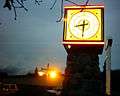 Clock tower
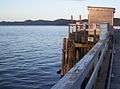 The Seagate Wharf in Port Hardy
 Carrot Campaign monument
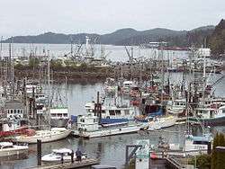
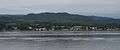 Port Hardy from the water
See also
- Tlatlasikwala Nation
- Da'naxda'xw Awaetlatla Nation (Tanakteuk First Nation)
- Kwakiutl First Nation (Fort Rupert Band)
- Hardy Island Marine Provincial Park
- Penrose Island Marine Provincial Park
References
- "British Columbia Regional Districts, Municipalities, Corporate Name, Date of Incorporation and Postal Address" (XLS). British Columbia Ministry of Communities, Sport and Cultural Development. Retrieved 2 November 2014.
- "District of Port Hardy Council Members".
- "Port Hardy". BC Geographical Names.
- "Nakwakto Rapids". Retrieved 29 March 2016.
- Akrigg, G.P.V.; Akrigg, Helen B. (1986), British Columbia Place Names (3rd, 1997 ed.), Vancouver: UBC Press, ISBN 0-7748-0636-2
- "Canadian Climate Normals 1981-2010 Station Data - Climate - Environment Canada". Environment Canada. Retrieved 16 February 2017.
- "Daily Data Report for September 1996". Environment Canada. Retrieved 10 April 2020.
| Subdivisions |  | |
|---|---|---|
| Communities | ||
| Metro areas and agglomerations |
| |
| District municipalities |
| |
| ||
| Authority control |
|
|---|