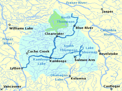
Clearwater, British Columbia
Clearwater is a district municipality in the North Thompson River valley in British Columbia, Canada, where the Clearwater River empties into the North Thompson River. It is located 124 km (77 mi) north of Kamloops. The District of Clearwater was established on December 23, 2007, making it one of the newest municipalities in British Columbia. It is near Wells Gray Provincial Park and is surrounded by the Trophy Mountains, Raft Mountain and Dunn Peak.
Clearwater | |
|---|---|
| District of Clearwater[1] | |
Clearwater roundabout near Southern Yellowhead Highway | |
 Location of Clearwater in British Columbia | |
| Coordinates: 51°39′N 120°02′W | |
| Country | Canada |
| Province | British Columbia |
| Regional District | Thompson-Nicola |
| Incorporated | 2007 |
| Area | |
| • Total | 55.68 km2 (21.50 sq mi) |
| Elevation | 460 m (1,510 ft) |
| Population (2016) | |
| • Total | 2,324 |
| • Density | 42/km2 (110/sq mi) |
| Time zone | UTC−8 (PST) |
| • Summer (DST) | UTC−7 (PDT) |
| Postal Code | V0E |
| Area code(s) | 250 / 778 / 236 |
| Highways | |
| Website | www |
History
Prior to European settlement, the area that is now occupied by the village was occupied by the Okelhs First Nations. They were eventually superseded by the Chilcotins in the 1870s.[2]
The fur trade brought the earliest settlers to the area. The Overlanders expedition to the Cariboo goldfields rafted down the North Thompson River in 1862. When they first arrived at the mouth of the Clearwater River, they named it for its distinct clarity compared to the relatively muddy waters of the North Thompson. The Overlanders also named Raft Mountain, which rises northeast of Clearwater to a height of 2,450 m (8,038 ft).[3]
Other dates
- 1914 - Rail access was established. Previously access had been by steam boat or overland.
- 1953 - Transmountain pipeline completed through area.
- 1970s -Yellowhead Highway complete through area.
- 1968 - Clearwater is incorporated as a settlement.
- December 2007 - Municipal government is incorporated.
Geography, location and climate
Geography
Clearwater is 406 metres above sea level. It is located in the North Thompson Valley in the Shuswap Highlands of the Interior Plateau. The Cariboo Mountains are located to the west and the Monashee Mountains to the east.[2]
Climate
| Climate data for Vavenby | |||||||||||||
|---|---|---|---|---|---|---|---|---|---|---|---|---|---|
| Month | Jan | Feb | Mar | Apr | May | Jun | Jul | Aug | Sep | Oct | Nov | Dec | Year |
| Record high °C (°F) | 12.8 (55.0) |
15.6 (60.1) |
22.8 (73.0) |
32.8 (91.0) |
37.8 (100.0) |
37.8 (100.0) |
41.1 (106.0) |
38.3 (100.9) |
35.0 (95.0) |
26.1 (79.0) |
20.0 (68.0) |
15.0 (59.0) |
41.1 (106.0) |
| Average high °C (°F) | −2.0 (28.4) |
1.5 (34.7) |
8.4 (47.1) |
15.1 (59.2) |
19.7 (67.5) |
23.0 (73.4) |
26.0 (78.8) |
25.7 (78.3) |
19.0 (66.2) |
10.4 (50.7) |
2.7 (36.9) |
−1.8 (28.8) |
12.3 (54.1) |
| Daily mean °C (°F) | −5.2 (22.6) |
−2.7 (27.1) |
2.7 (36.9) |
8.0 (46.4) |
12.3 (54.1) |
15.7 (60.3) |
18.2 (64.8) |
17.6 (63.7) |
12.1 (53.8) |
5.7 (42.3) |
−0.2 (31.6) |
−4.7 (23.5) |
6.6 (43.9) |
| Average low °C (°F) | −8.3 (17.1) |
−6.8 (19.8) |
−3.0 (26.6) |
0.9 (33.6) |
4.8 (40.6) |
8.4 (47.1) |
10.3 (50.5) |
9.4 (48.9) |
5.1 (41.2) |
0.9 (33.6) |
−3.1 (26.4) |
−7.6 (18.3) |
0.9 (33.6) |
| Record low °C (°F) | −46.1 (−51.0) |
−41.1 (−42.0) |
−31.7 (−25.1) |
−16.1 (3.0) |
−7.2 (19.0) |
−3.3 (26.1) |
0.6 (33.1) |
−1.7 (28.9) |
−8.3 (17.1) |
−19.0 (−2.2) |
−32.0 (−25.6) |
−41.7 (−43.1) |
−46.1 (−51.0) |
| Average precipitation mm (inches) | 39.5 (1.56) |
22.4 (0.88) |
25.0 (0.98) |
29.8 (1.17) |
43.8 (1.72) |
56.5 (2.22) |
58.2 (2.29) |
43.1 (1.70) |
37.2 (1.46) |
43.2 (1.70) |
44.1 (1.74) |
41.4 (1.63) |
484.1 (19.06) |
| Average rainfall mm (inches) | 12.3 (0.48) |
10.7 (0.42) |
20.0 (0.79) |
29.0 (1.14) |
43.6 (1.72) |
56.5 (2.22) |
58.2 (2.29) |
43.1 (1.70) |
37.2 (1.46) |
43.2 (1.70) |
26.8 (1.06) |
10.9 (0.43) |
389.3 (15.33) |
| Average snowfall cm (inches) | 27.2 (10.7) |
11.7 (4.6) |
5.0 (2.0) |
0.9 (0.4) |
0.1 (0.0) |
0 (0) |
0 (0) |
0 (0) |
0 (0) |
2.2 (0.9) |
17.3 (6.8) |
30.4 (12.0) |
94.8 (37.3) |
| Source: [4] | |||||||||||||
Demographics
The town had a population of 2,324 according to the 2016 Census. The 2017 unemployment rate was 5.7%.[5] The majority of residents are married or live common law. Nearly all residents speak English as their mother tongue though there is a small proportion who speak French.[6]
Industry
Forestry
Forestry is the principal industry in the area. There was one major mill in the area, in Vavenby,[7] but that mill was closed permanently by Canfor in 2019.[8] There are several woodlot licenses within the area.
Agriculture
There is local production of beef, alfalfa, hay crops and vegetables.[9]
Tourism
The town of Clearwater calls itself the "gateway to Wells Gray Provincial Park", as the main access to the park is through the town. Within the town is the Wells Gray Visitor Information Centre. In 2012 the total number of tourism based visitors was 578,445. In 2011 the estimated economic impact of tourism in Wells Gray Country was $21,513,261. Sports tourism is also a growth sector for the community.[10]
Sports
Parks
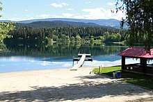
Within the city there are 7 parks; Capostinsky Park, Chad Memorial Park, Dutch Lake park, Raft River Viewing Park, Rotary Sports Park, Weyerhaeuser Pioneer Park and Wyndhaven Park.[13] Dutch Lake Park has a beach and there are a number of water activities there in the summer as well as ice fishing in the winter.
Wells Gray Provincial Park is located just to the north. The park encompasses 5,250 square kilometres, with four rivers, six major lakes, and 39 named waterfalls, including Canada's fourth highest, Helmcken Falls.
Mountain biking
A mountain bike park is located at Candle Creek, east of the city centre. This consists of 13 km of mountain and cross country trails.[14] There are also trails present that head North from the city into Wells Gray park.
Cross country skiing / snowshoeing
A series of cross country ski trails and snowshoeing trails are present at Candle Creek, east of the city centre.[15]
Education
K - 12
Clearwater has two schools: Raft River Elementary with approximately 300 students and Clearwater Secondary School with about 225 students. Clearwater Secondary School's team sports are named "The Raiders" and include soccer, volleyball, and basketball. Currently, they play in single "A" categories. The school falls under the jurisdiction of School District #73.[2]
Post Secondary
The closest University to the town is Thompson Rivers University in Kamloops. The University has a branch location in the town which provides a limited number of specialized courses.[17]
Healthcare
Hospital
| Dr. Helmcken Memorial Hospital | |
|---|---|
| Interior Health | |
| Geography | |
| Location | Clearwater, British Columbia, British Columbia, Canada |
| Organization | |
| Care system | Medicare |
| Type | General, Teaching |
| Affiliated university | UBC Faculty of Medicine |
| Services | |
| Emergency department | Yes |
| History | |
| Opened | 1972 |
| Links | |
| Website | https://www.interiorhealth.ca/FindUs/_layouts/FindUs/info.aspx?type=Location&loc=Dr.%20Helmcken%20Memorial%20Hospital&svc=&ploc= |
The community is serviced locally by Dr. Helmcken Memorial Hospital, a level 1 community hospital. It has an emergency department, acute care beds as well as long care beds. This hospital refers patients to Royal Inland Hospital in Kamloops.[18]
The hospital was originally founded in 1972 and consisted of several portable buildings connected together.[19] Prior to its construction there was no prior hospital in the area, no prior regular physician and no drug store. A new multi-level hospital was opened June 10, 2002.[20] The original hospital structure was demolished in 2016. It is named after Dr. Helmcken, who came to BC in the early 1900s.[21]
Assisted Living
Assisted living is provided in the adjacent Evergreen Acres and is scheduled for an expansion.[22]
Transportation
- Road - Clearwater is located on the Yellowhead Highway #5. Its closest major junctions are to the south (Highway 24 in Little Fort) and to the North (Yellowhead Highway #16), diverging between Prince George and Edmonton.
- Rail - Via Rail's The Canadian calls at the Clearwater station three times per week in each direction; this is a flag stop. The Canadian National Railway mainline runs through the town.
- Air - Scenic flights and fixed-wing air charter services are provided by Wells Gray Air from the Clearwater Airport. International and domestic scheduled air service is provided in Kamloops. Chartered helicopter service is also available.
- Bus - For travel outside of the city there is a community service bus provided by BC transit.[23] With the closure of Greyhound Lines Canadian routes, there is no longer any commercial bus service to the town, though there are plans for this in the future.[24] For travel within the town there is scheduled bus service with limited ride times.[25]
References
- "British Columbia Regional Districts, Municipalities, Corporate Name, Date of Incorporation and Postal Address" (XLS). British Columbia Ministry of Communities, Sport and Cultural Development. Archived from the original on July 13, 2014. Retrieved November 2, 2014.
- "Archived copy" (PDF). Archived from the original (PDF) on 2006-05-16. Retrieved 2019-03-16.CS1 maint: archived copy as title (link)
- Neave, Roland (2004). Exploring Wells Gray Park, 5th edition. Wells Gray Tours, Kamloops, BC. ISBN 0-9681932-1-8.
- "Calculation Information for 1950 to 2007 Canadian Normals Data". Environment Canada. Retrieved February 27, 2017.
- "Community profile". districtofclearwater.civicweb.net. Retrieved 2019-09-06.
- "Census Profile, 2016 Census - Canada [Country] and Clearwater, District municipality [Census subdivision], British Columbia". 2.statcan.gc.ca. Retrieved 2019-09-06.
- "Canfor-Vavenby Mill scheduled to re open". Barriere Star Journal. July 18, 2011.
- "Canfor to permanently close Vavenby sawmill". www.cbc.ca. June 4, 2019. Retrieved 2019-09-06.
- "Key Economic Sectors : District of Clearwater". www.districtofclearwater.com.
- "Microsoft Word - Revised Nov 2016_TWG 2017-2022 5 Yr Strategic Plan.docx" (PDF). Retrieved 2019-09-06.
- Canada, Impact Assessment Agency of (May 30, 2014). "Ruddock Creek Mine Project". www.ceaa-acee.gc.ca.
- Canada, Impact Assessment Agency of (April 27, 2011). "Harper Creek Mine Project". www.ceaa-acee.gc.ca.
- "Community Parks : District of Clearwater". www.districtofclearwater.com.
- "Summer – Wells Gray Outdoors Club".
- "Winter – Wells Gray Outdoors Club".
- "clearwater ski hill ski runs". clearwaterskihill.com.
- www.tru.ca, Thompson Rivers University. "Clearwater Regional Centre, Thompson Rivers University". Thompson Rivers University.
- "Information Page". www.interiorhealth.ca.
- "UPDATE: Former hospital demolished". BC Local News. October 14, 2016.
- "History". Dr. Helmcken Memorial Hospital Auxiliary.
- "History of Wells Gray Park | News & Blog | Alpine Meadows Resort, BC". July 20, 2018.
- "Evergreen Acres receives provincial funding". Clearwater Times. November 22, 2018.
- "Yellowhead Community Services :: Transit". www.yellowheadcs.ca.
- "New bus route to 'replace' Greyhound along Trans-Canada Highway". Clearwater Times. October 16, 2018.
- "Riders guide" (PDF). www.tnrd.ca. Retrieved 2019-09-06.
| Subdivisions |  | |
|---|---|---|
| Communities | ||
| Metro areas and agglomerations |
| |
| District municipalities |
| |
| ||