Port Renfrew
Port Renfrew is a community on the west coast of Vancouver Island, British Columbia, Canada, located about a 2-hour drive west of Victoria, British Columbia. Port Renfrew is the western terminus of the Juan de Fuca Marine Trail.
Port Renfrew | |
|---|---|
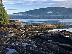 Port San Juan from Port Renfrew | |
| Nickname(s): The Land of Plenty, The Tall Tree Capital of Canada | |
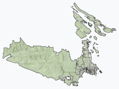 Port Renfrew Location of Port Renfrew within the Capital Regional District | |
 Port Renfrew Location of Port Renfrew in British Columbia | |
| Coordinates: 48°33′31″N 124°23′57″W | |
| Country | |
| Province | |
| Area | |
| • Land | 8.69 km2 (3.36 sq mi) |
| Population (2016) | |
| • Total | 144 |
| • Density | 16.6/km2 (43/sq mi) |
| Website | https://www.portrenfrew.com |
History
Port Renfrew is the home of the Pacheedaht First Nation, meaning "People of the Sea Foam", who have traditional village sites in and around the main town centre. The southern trailhead of the West Coast Trail, a world-famous hiking trail built in 1907 along the west coast of Vancouver Island to save shipwrecked sailors, is located on the Gordan River adjacent to Port Renfrew. The town is situated on the coast of the pacific ocean surrounded by large mountains covered with trees. This cove-like town is a peaceful getaway for all those interested in nature, hikes, fishing and many more extravagant activities. Like Sooke, B.C, Port Renfrew is a sport fishing paradise. Being located on the Pacific Ocean, it is excellent for catching Salmon and Halibut fishing and is one of the World-Class Sports fishing Destinations. The rich waters open up many fishing industries, and with their beautiful mountain top views, it brings in plenty of tourists and expands the economy of Port Renfrew. During the days of sail, 1830–1925, 137 major shipping tragedies occurred in the immediate vicinity of the entrance to the Strait of Juan de Fuca. International recognition was given to this stretch of water off Port Renfrew. It became known as the Graveyard of the Pacific. Originally named Port San Juan, the settlers changed the name to honor Lord Renfrew who planned to settle crofters there. The name was changed due to mail being sent to the San Juan Islands instead of Port San Juan. Port Renfrew's bay is still called Port San Juan. Like many coastal Vancouver Island communities, Port Renfrew has a rich history in forestry and fishing.
Tourism and attractions
In recent years, Port Renfrew has seen an increase in tourism. The Ancient Forest Alliance (AFA) has worked hard to locate and preserve some of North America's largest trees located around Port Renfrew. This preservation is paying off as people from all over the globe are now witnessing Avatar Grove and Canada's "gnarliest tree." The Red Creek fir, the world's largest Douglas fir, and San Juan Spruce, Canada's largest Sitka spruce, are also located in the area. Port Renfrew is filled with options that encompass all outdoor enthusiasts' needs. Local natural attractions include the West Coast Trail, Juan de Fuca Trail and Botanical Beach. Since 2010 the Tall Tree music festival has been held in Port Renfrew on the last weekend in June. Port Renfrew is considered one of the best locations for salmon and halibut fishing in North America. There is also excellent sea and freshwater (San Juan and Jordan River) kayaking and birding. The locals of Port Renfrew have been enjoying those trails and forests for decades.
Port Renfrew can be accessed from Victoria via Highway 14 or from Lake Cowichan via the Pacific Marine Circle Road.
Climate
The climate is classic oceanic (Köppen: Cfb), because it is close to the Strait of Juan de Fuca towards the interior, the Mediterranean trend of rainfall patterns begins to be evidenced with high annual rainfall (proximity to the Csb), in terms of temperature is similar the Channel Islands. Summers are warm and almost fresh and winters are mild, one of the mildest in all of Canada.[1][2][3]
| Climate data for Port Renfrew | |||||||||||||
|---|---|---|---|---|---|---|---|---|---|---|---|---|---|
| Month | Jan | Feb | Mar | Apr | May | Jun | Jul | Aug | Sep | Oct | Nov | Dec | Year |
| Record high °C (°F) | 19.0 (66.2) |
16.5 (61.7) |
20.0 (68.0) |
24.5 (76.1) |
27.5 (81.5) |
31.0 (87.8) |
31.7 (89.1) |
33.5 (92.3) |
28.9 (84.0) |
24.0 (75.2) |
17.2 (63.0) |
15.0 (59.0) |
33.5 (92.3) |
| Average high °C (°F) | 6.3 (43.3) |
7.5 (45.5) |
9.7 (49.5) |
12.3 (54.1) |
15.2 (59.4) |
17.4 (63.3) |
19.4 (66.9) |
20.0 (68.0) |
17.8 (64.0) |
12.9 (55.2) |
8.5 (47.3) |
5.9 (42.6) |
12.7 (54.9) |
| Daily mean °C (°F) | 4.1 (39.4) |
4.6 (40.3) |
6.2 (43.2) |
8.4 (47.1) |
11.1 (52.0) |
13.4 (56.1) |
15.3 (59.5) |
15.6 (60.1) |
13.4 (56.1) |
9.6 (49.3) |
6.1 (43.0) |
3.8 (38.8) |
9.3 (48.7) |
| Average low °C (°F) | 1.8 (35.2) |
1.6 (34.9) |
2.7 (36.9) |
4.3 (39.7) |
6.9 (44.4) |
9.4 (48.9) |
11.0 (51.8) |
11.1 (52.0) |
9.0 (48.2) |
6.3 (43.3) |
3.7 (38.7) |
1.6 (34.9) |
5.8 (42.4) |
| Record low °C (°F) | −12.5 (9.5) |
−10.5 (13.1) |
−6.7 (19.9) |
−2.5 (27.5) |
0.0 (32.0) |
1.7 (35.1) |
5.0 (41.0) |
2.2 (36.0) |
−0.6 (30.9) |
−3.5 (25.7) |
−11.5 (11.3) |
−11.1 (12.0) |
−12.5 (9.5) |
| Average precipitation mm (inches) | 555.7 (21.88) |
376.6 (14.83) |
362.3 (14.26) |
258.7 (10.19) |
154.7 (6.09) |
107.9 (4.25) |
50.5 (1.99) |
82.4 (3.24) |
123.9 (4.88) |
371.2 (14.61) |
579.7 (22.82) |
481.0 (18.94) |
3,504.6 (137.98) |
| Average rainfall mm (inches) | 544.0 (21.42) |
362.0 (14.25) |
356.0 (14.02) |
258.1 (10.16) |
154.6 (6.09) |
107.9 (4.25) |
50.5 (1.99) |
82.4 (3.24) |
123.9 (4.88) |
371.0 (14.61) |
575.4 (22.65) |
468.9 (18.46) |
3,454.7 (136.01) |
| Average snowfall cm (inches) | 12 (4.7) |
15 (5.9) |
6 (2.4) |
1 (0.4) |
0 (0) |
0 (0) |
0 (0) |
0 (0) |
0 (0) |
0 (0) |
4 (1.6) |
12 (4.7) |
50 (20) |
| Average precipitation days (≥ 0.2 mm) | 22.8 | 18.4 | 22.3 | 19.3 | 16.7 | 13.9 | 9.0 | 9.6 | 11.1 | 18.8 | 23.1 | 22.4 | 207.3 |
| Average rainy days (≥ 0.2 mm) | 22.1 | 17.8 | 22.0 | 19.3 | 16.7 | 13.9 | 9.0 | 9.6 | 11.1 | 18.8 | 22.8 | 21.5 | 204.7 |
| Average snowy days (≥ 0.2 cm) | 2.9 | 2.2 | 2.0 | 0.33 | 0.04 | 0.0 | 0.0 | 0.0 | 0.0 | 0.08 | 1.0 | 2.5 | 11.1 |
| Source: [4] | |||||||||||||
Nearby communities
- Jordan River
- Sooke
- Victoria
Trivia
- Port Renfrew often surprises tourists as it appears on maps as a much more substantial town than it actually is, since it is the only town within its vicinity: BC-14 is a dead end street ending at a federal government pier (although the road does continue for several kilometres past the town centre, ending at Botanical Beach, the north-west point of Juan de Fuca Provincial Park). The Pacific Marine Circle Route, completed in 2009, connects Port Renfrew to Lake Cowichan completing a South Island Loop for Victoria, Sooke, Port Renfrew, Lake Cowichan, Duncan and back to Victoria. Total driving time is approximately 4½ hours.
References
- "Port Renfrew climate: Average Temperature, weather by month, Port Renfrew weather averages - Climate-Data.org". en.climate-data.org. Retrieved 23 February 2019.
- "Climate & Weather | Vancouver Island, BC | Destination BC – Official Site". web.archive.org. 11 September 2017. Retrieved 23 February 2019.
- "Climate types in the Canada (according of the Köppen)".
- "Canadian Climate Normals 1981–2010 Station Data". Environment Canada. Retrieved 12 September 2014.