Port Blair
Port Blair (![]()
Port Blair | |
|---|---|
City | |
.jpg) 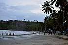 .jpg) 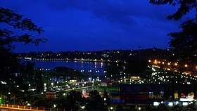 From upper left: Ariel view of Port Blair, A Beach in Port Blair, View from South Point, Port Blair at night. | |
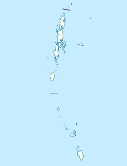 Port Blair Location in the Andaman and Nicobar Islands 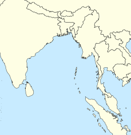 Port Blair Port Blair (Bay of Bengal) | |
| Coordinates: 11°40′06″N 92°44′16″E | |
| Country | |
| Union Territory | Andaman and Nicobar Islands |
| District | South Andaman |
| Government | |
| • Type | Mayor–Council |
| • Body | Port Blair Municipal Council (PBMC) |
| Area | |
| • Total | 94.34 km2 (36.42 sq mi) |
| Elevation | 16 m (52 ft) |
| Population (2011)[1] | |
| • Total | 100,186[1] |
| Time zone | UTC+5.30 (IST) |
| Climate | Am |
Port Blair serves as the entry point for visiting the Andaman and Nicobar Islands. Port Blair is connected with mainland India by both air and sea. It is a 2-3 hour flight from mainland India to Port Blair's Veer Savarkar International Airport, and 3–4 days by sea to reach Kolkata, Chennai or Visakhapatnam from Haddo Wharf in Port Blair. It is home to several museums and a major naval base INS Jarawa of the Indian Navy, along with sea and air bases of the Indian Coast Guard, Andaman and Nicobar Police, Andaman and Nicobar Command, the first integrated tri-command of the Indian Armed Forces and the Indian Air Force.[2]
Port Blair is also famous for the historic Cellular Jail and other small islands like Corbyn's Cove, Wandoor, Ross Island, Viper Island etc.[3] which were once home to British colonists. Port Blair has been selected as one of the cities to be developed as a smart city under the Smart Cities Mission.[4]
History
Pre-history
Since their migration out of North Africa 60,000 years ago, Andaman tribes have lived in close-knit communities.[5] Genome studies prove that Andamane tribes split from the tree of human evolution of their out of Africa ancestors 30,000 years ago, and radiocarbon dating studies of the kitchen refuse dumps from the mounds excavated by the Anthropological Survey of India at Choladari near Port Blair provide another proof that Andaman tribes have been living here at least 2,000 years.[6][7]
Modern history
In 1789 the Government of Bengal established a penal colony on Chatham Island in the southeast bay of Great Andaman, named Port Blair in the honor of Archibald Blair of the East India Company. After two years, the colony moved to the northeast part of Great Andaman and was named Port Cornwallis after Admiral William Cornwallis. However, there was much disease and death in the penal colony, and the government ceased operating it in May 1796.
In 1824 Port Cornwallis was the rendezvous of the fleet carrying the army to the First Anglo-Burmese War. In the 1830s and 1840s, shipwrecked crews who landed on the Andamans were often attacked and killed by the natives, alarming the British government. In 1855, the government proposed another settlement on the islands, including a convict establishment, but the Indian Rebellion forced a delay in its construction.
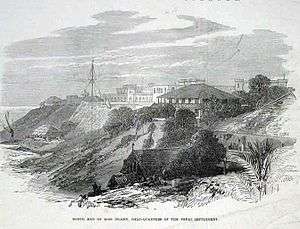
However, since the rebellion provided the British with a lot of new prisoners, it made the new Andaman settlement and prison an urgent necessity. Construction began in November 1857 at the renovated Port Blair, avoiding the vicinity of a salt swamp which seemed to have been the source of many of the old colony's problems. The penal colony was originally on Viper Island. The convicts, mostly political prisoners, suffered life imprisonment at hard labor under cruel and degrading conditions. Many were hanged, while others died of disease and starvation. Between 1864 and 1867 a penal establishment was also built with convict labour on the northern side of Ross Island.[8] These structures now lie in ruins.[9]
As the Indian freedom movement continued to grow in the late 19th century, the enormous Cellular Jail was constructed between 1896 and 1906 to house Indian convicts, mostly political prisoners, in solitary confinement. The Cellular Jail is also known as Kala Pani (translated as "Black Waters"), a name given to it due to the torture and general ill-treatment towards its Indian convicts.
The airport at Port Blair, Andaman and Nicobar's capital, has been named Veer Savarkar International Airport. The commemorative blue plaque on India House fixed by the Historic Building and Monuments Commission for England reads "Vinayak Damodar Savarkar 1883–1966 Indian patriot and philosopher lived here."
In World War II the islands were occupied by the Japanese on 23 March 1942 without opposition from the garrison. British forces returned to the islands in October 1945.[10]
From 1943–44 during World War II, Port Blair served as the headquarters of the Azad Hind government under Subhas Chandra Bose.
Although affected by the 2004 Indian Ocean earthquake and tsunami, Port Blair survived sufficiently to act as a base for relief efforts in the islands.
Climate
Port Blair has a tropical monsoon climate (Köppen climate classification Am), with little variation in average temperature and large amounts of precipitation throughout the year. All months except January, February and March receive substantial rainfall.
Climate data for Port Blair (1981–2010, extremes 1901–present) | |||||||||||||
|---|---|---|---|---|---|---|---|---|---|---|---|---|---|
| Month | Jan | Feb | Mar | Apr | May | Jun | Jul | Aug | Sep | Oct | Nov | Dec | Year |
| Record high °C (°F) | 32.7 (90.9) |
34.6 (94.3) |
35.4 (95.7) |
36.4 (97.5) |
36.4 (97.5) |
35.6 (96.1) |
32.8 (91.0) |
32.5 (90.5) |
35.4 (95.7) |
35.6 (96.1) |
34.0 (93.2) |
35.4 (95.7) |
36.4 (97.5) |
| Mean maximum °C (°F) | 30.7 (87.3) |
31.4 (88.5) |
33.1 (91.6) |
33.8 (92.8) |
33.3 (91.9) |
31.3 (88.3) |
30.8 (87.4) |
30.5 (86.9) |
30.7 (87.3) |
31.1 (88.0) |
31.2 (88.2) |
30.6 (87.1) |
34.0 (93.2) |
| Average high °C (°F) | 29.5 (85.1) |
30.2 (86.4) |
31.3 (88.3) |
32.3 (90.1) |
31.2 (88.2) |
29.8 (85.6) |
29.4 (84.9) |
29.2 (84.6) |
29.2 (84.6) |
29.7 (85.5) |
29.8 (85.6) |
29.5 (85.1) |
30.1 (86.2) |
| Daily mean °C (°F) | 26.0 (78.8) |
26.3 (79.3) |
27.2 (81.0) |
28.2 (82.8) |
27.7 (81.9) |
26.9 (80.4) |
26.6 (79.9) |
26.5 (79.7) |
26.2 (79.2) |
26.4 (79.5) |
26.8 (80.2) |
26.4 (79.5) |
26.8 (80.2) |
| Average low °C (°F) | 22.4 (72.3) |
22.1 (71.8) |
22.7 (72.9) |
24.1 (75.4) |
24.2 (75.6) |
23.9 (75.0) |
23.8 (74.8) |
23.6 (74.5) |
23.0 (73.4) |
23.0 (73.4) |
23.3 (73.9) |
23.0 (73.4) |
23.3 (73.9) |
| Mean minimum °C (°F) | 18.8 (65.8) |
19.4 (66.9) |
20.0 (68.0) |
22.2 (72.0) |
21.9 (71.4) |
20.9 (69.6) |
21.4 (70.5) |
21.1 (70.0) |
21.1 (70.0) |
21.4 (70.5) |
21.1 (70.0) |
19.6 (67.3) |
18.1 (64.6) |
| Record low °C (°F) | 14.8 (58.6) |
15.9 (60.6) |
16.2 (61.2) |
17.3 (63.1) |
17.1 (62.8) |
14.6 (58.3) |
18.0 (64.4) |
17.4 (63.3) |
16.8 (62.2) |
17.8 (64.0) |
17.3 (63.1) |
16.2 (61.2) |
14.6 (58.3) |
| Average rainfall mm (inches) | 32.1 (1.26) |
16.8 (0.66) |
32.5 (1.28) |
75.8 (2.98) |
368.8 (14.52) |
448.2 (17.65) |
442.5 (17.42) |
446.4 (17.57) |
458.3 (18.04) |
301.4 (11.87) |
242.4 (9.54) |
103.2 (4.06) |
2,968.3 (116.86) |
| Average rainy days | 1.4 | 1.0 | 1.6 | 4.1 | 15.9 | 18.8 | 18.6 | 19.1 | 18.8 | 15.5 | 11.6 | 4.5 | 130.8 |
| Average relative humidity (%) (at 17:30 IST) | 74 | 72 | 72 | 74 | 81 | 84 | 84 | 85 | 87 | 85 | 82 | 75 | 80 |
| Mean monthly sunshine hours | 266.6 | 265.6 | 266.6 | 237.0 | 158.1 | 90.0 | 102.3 | 99.2 | 117.0 | 167.4 | 189.0 | 241.8 | 2,200.6 |
| Mean daily sunshine hours | 8.6 | 9.4 | 8.6 | 7.9 | 5.1 | 3.0 | 3.3 | 3.2 | 3.9 | 5.4 | 6.3 | 7.8 | 6.0 |
| Source 1: India Meteorological Department[11][12][13][14] | |||||||||||||
| Source 2: Tokyo Climate Center (mean temperatures 1981–2010)[15] | |||||||||||||
Demographics
Population
As of 2011 India census,[16] Port Blair had a population of 100,608. Males constitute 52.92% (53,247) of the population and females 47.07% (47,361).9.3% of the population is under the age of 6 years.
Literacy
Port Blair has an average literacy rate of 89.76%, higher than the national average that is 74.04%. In Port Blair, male literacy is 92.79%, and female literacy is 86.34%.
Religion
The most common religion is Hinduism, followed by Christianity and Islam.
Language
Bengali is the most spoken language of the city, followed by Hindi, Tamil and Telugu.
Tourism
Tourism plays a big role in the economy of the Andaman and Nicobar Islands.
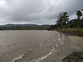 Beach Of Port Blair
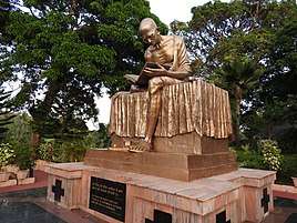 Gandhi statue, Gandhi park
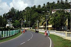 PortBlair SeasideRoad
 Cellular Jail
 Science Centre Port Blair
 Jaljeevshala-Aquarium at Port Blair
.jpg) Port Blair - Water scooter ride
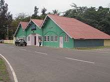
Port Blair - Water scooter ride Aberdeen clock tower
 Tsunami Memorial In Port Blair
See also
References
- "Census of India Search details". censusindia.gov.in. Retrieved 10 May 2015.
- "Andaman and Nicobar command". NIC. Retrieved 1 July 2013.
- "Places to visit in Port Blair". Andamansguide. 21 September 2016. Retrieved 13 October 2016.
- Khanna, Pretika (24 May 2016). "13 cities included in Phase 1 of Smart Cities Mission". LiveMint. Retrieved 4 January 2017.
- Beyond killing of American national: Sovereign citizens of India, India Today, 21 Nov 2018.
- Ghai, Rajat (27 November 2018). "Leave the Sentinelese alone". downtoearth.org.in. Retrieved 3 February 2019.
- US Man's Body Should Be Left Alone, As Should The Andaman Tribe: Experts, NDTV, 27 November 2018.
- "Archived copy". Archived from the original on 27 December 2008. Retrieved 27 December 2008.CS1 maint: archived copy as title (link) T. Ramakrishnan, "Notorious Once, It Stands Shrouded in Silence"
- http://www.galenfrysinger.com/ross_island.htm Archived 4 March 2016 at the Wayback Machine Ross Island
- Jayant Dasgupta (2002). Japanese in Andaman & Nicobar Islands: red sun over black water. Manas Publications. ISBN 978-81-7049-138-5.
- "Station: Port Blair Climatological Table 1981–2010" (PDF). Climatological Normals 1981–2010. India Meteorological Department. January 2015. pp. 619–620. Archived from the original (PDF) on 5 February 2020. Retrieved 10 February 2020.
- "Extremes of Temperature & Rainfall for Indian Stations (Up to 2012)" (PDF). India Meteorological Department. December 2016. p. M4. Archived from the original (PDF) on 5 February 2020. Retrieved 10 February 2020.
- "Port Blair Climatological Table 1981–2010". India Meteorological Department. Retrieved 10 February 2020.
- "Table 3 Monthly mean duration of Sun Shine (hours) at different locations in India" (PDF). Daily Normals of Global & Diffuse Radiation (1971–2000). India Meteorological Department. December 2016. p. M-3. Archived from the original (PDF) on 5 February 2020. Retrieved 10 February 2020.
- "Normals Data: Port Blair - India Latitude: 11.67°N Longitude: 92.72°E Height: 79 (m)". Japan Meteorological Agency. Archived from the original on 1 March 2020. Retrieved 1 March 2020.
- "Census of India 2001: Data from the 2001 Census, including cities, villages and towns (Provisional)". Census Commission of India. Archived from the original on 16 June 2004. Retrieved 1 November 2008.
External links

| Wikimedia Commons has media related to Port Blair. |
| Authority control |
|
|---|