Kohima
Kohima (/koʊˈhiːmə/ ![]()
Kohima | |
|---|---|
  Nightscape of Kohima(Top), P.R. Hill Junction (Bottom) | |
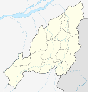 Kohima Location of Kohima in Nagaland  Kohima Kohima (India) | |
| Coordinates: 25.6701°N 94.1077°E | |
| Country | |
| State | |
| District | Kohima |
| Government | |
| • Type | Municipality |
| • Body | Kohima Municipal Council |
| • Chairman | Kovi Meyase |
| Area | |
| • Total | 20 km2 (8 sq mi) |
| Elevation | 1,444 m (4,738 ft) |
| Population (2011) | |
| • Total | 115,283[1] |
| Demonym(s) | Kohimian kewhi–mia |
| Languages | |
| • Official | English |
| • Dialects | Angami Ao Chakhesang Lotha Sumi |
| Time zone | UTC+5:30 (IST) |
| PIN | 797001 |
| Telephone code | 91 (0)370 |
| Vehicle registration | NL-01 |
| Sex ratio | 927 ♂/♀ |
| Website | kohima |
Kohima constitutes both a district and a municipality. The municipality covers 20 km2 (7.7 sq mi). Kohima lies on the foothills of Japfü range located south of the District (25.67°N 94.12°E)[5] and has an average elevation of 1,261 metres (4137 feet).[6]
Etymology
Kohima was originally known as Kewhi–ra.[7] The name, Kohima, was officially given by the British as they could not pronounce the Angami name of Kewhi–ra (Tenyidie for "the land where the flower ‘Kewhi’ grows"). It is called after the wild flowering plant ‘Kewhi’, found in the mountains. Most local people prefer to use ‘Kewhi–ra’.
History
Kohima was originally a large village named Kewhira, which is located in the northeastern part of the present day Kohima urban area. The village is divided into four Thinuos: Tsütuonuomia, Lhisemia, Dapfütsumia and Pfuchatsumia (T, L, D, and P Khel respectively).
Battle of Kohima
The British incursions into the Naga territory, beginning in the 1840s, met with stiff resistance from the independence-loving Nagas, who had never been conquered by any empire before. The stiffness of the resistance can be gauged by the fact that it took nearly four decades for the British to conquer a territory that is less than 10,000 square kilometres (the eastern region was left free). Kohima was the first seat of modern administration as the Headquarters of Naga Hills District (then under Assam) with the appointment of Guybon Henry Damant as Political Officer in 1879. When Nagaland became a full-fledged state on 1 December 1963, Kohima was christened as the state capital.
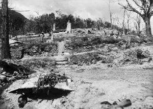
In 1944 during World War II the Battle of Kohima along with the simultaneous Battle of Imphal was the turning point in the Burma Campaign. For the first time in South-East Asia the Japanese lost the initiative to the Allies which the Allies then retained until the end of the war. This hand-to-hand battle and slaughter prevented the Japanese from gaining a high base from which they might next roll across the extensive flatlands of India.[8]
.jpeg)
Kohima has a large cemetery known as the War Cemetery in Kohima for the Allied war dead maintained by the Commonwealth War Graves Commission. The cemetery lies on the slopes of Garrison Hill, in what was once the Deputy Commissioner's tennis court which was the scene of intense fighting, the Battle of the Tennis Court. The epitaph carved on the memorial of the 2nd British Division in the cemetery has become world-famous as the Kohima poem.
When You Go Home, Tell Them Of Us And Say,
For Your Tomorrow, We Gave Our Today.
The verse is attributed to John Maxwell Edmonds (1875–1958), and is thought to have been inspired by the epitaph written by Simonides to honour the Greek who fell at the Battle of Thermopylae in 480 BC.[9]
Geography
Kohima lies north of the Japfü Barail intersection.
Climate
The city experiences the subtropical highland climate (Köppen: Cwb), with greater contrast between summer and winter than in other continents due to the monsoons and mild temperatures even for latitude and altitude. The months of June to September concentrate much of the precipitation.[10]
Kohima has cool winters with rarefied rain sometimes warm (but not hot) and very rainy summers. The coldest months are from December to February, when frost occurs and in the higher altitudes snowfall occurs occasionally. During the height of summers, from June–August, temperature ranges an average of 27–32 °C (80–90 °F). Heavy rainfall occurs during summer.
Climate data for Kohima (1961–1990, extremes 1952–2012) | |||||||||||||
|---|---|---|---|---|---|---|---|---|---|---|---|---|---|
| Month | Jan | Feb | Mar | Apr | May | Jun | Jul | Aug | Sep | Oct | Nov | Dec | Year |
| Record high °C (°F) | 24.5 (76.1) |
25.0 (77.0) |
29.1 (84.4) |
32.2 (90.0) |
33.9 (93.0) |
30.5 (86.9) |
33.1 (91.6) |
31.1 (88.0) |
31.0 (87.8) |
31.5 (88.7) |
29.5 (85.1) |
26.0 (78.8) |
33.9 (93.0) |
| Average high °C (°F) | 15.5 (59.9) |
17.7 (63.9) |
21.7 (71.1) |
23.8 (74.8) |
23.8 (74.8) |
24.7 (76.5) |
25.1 (77.2) |
25.3 (77.5) |
24.8 (76.6) |
23.7 (74.7) |
20.7 (69.3) |
17.9 (64.2) |
22.1 (71.8) |
| Daily mean °C (°F) | 11.6 (52.9) |
13.4 (56.1) |
17.3 (63.1) |
19.6 (67.3) |
20.4 (68.7) |
21.6 (70.9) |
21.5 (70.7) |
21.6 (70.9) |
21.3 (70.3) |
20.1 (68.2) |
16.6 (61.9) |
13.4 (56.1) |
18.2 (64.8) |
| Average low °C (°F) | 8.0 (46.4) |
9.3 (48.7) |
11.2 (52.2) |
15.0 (59.0) |
16.6 (61.9) |
17.8 (64.0) |
18.7 (65.7) |
18.9 (66.0) |
17.9 (64.2) |
16.7 (62.1) |
13.1 (55.6) |
9.2 (48.6) |
14.5 (58.1) |
| Record low °C (°F) | 0.6 (33.1) |
2.3 (36.1) |
4.0 (39.2) |
5.0 (41.0) |
8.3 (46.9) |
9.4 (48.9) |
7.8 (46.0) |
8.3 (46.9) |
8.9 (48.0) |
5.0 (41.0) |
3.1 (37.6) |
2.2 (36.0) |
0.6 (33.1) |
| Average rainfall mm (inches) | 9.6 (0.38) |
24.0 (0.94) |
48.4 (1.91) |
92.2 (3.63) |
133.4 (5.25) |
323.6 (12.74) |
363.3 (14.30) |
360.7 (14.20) |
228.6 (9.00) |
134.8 (5.31) |
32.5 (1.28) |
5.8 (0.23) |
1,756.9 (69.17) |
| Average rainy days | 1.2 | 2.5 | 4.5 | 8.3 | 12.2 | 19.0 | 22.1 | 19.3 | 16.4 | 9.1 | 2.3 | 0.6 | 117.5 |
| Average relative humidity (%) | 74 | 67 | 65 | 70 | 77 | 85 | 88 | 88 | 86 | 83 | 76 | 71 | 78 |
| Source: India Meteorological Department[11][12] | |||||||||||||
Administration
The Kohima Municipal Council (KMC) was established in 2005 under India's Constitution (Seventy-Fourth Amendment) Act, 1992. It has waste management, drainage and trade licensing and other responsibilities.[13][14]
Other departments of the state government, which sit in Kohima, also have a role in the administration of Kohima.[14] The "City Development Plan" for the town, for example, was written by state Urban Development Department.[15]
Greater Kohima planning area
The Greater Kohima Planning Area (GKPA) comprises the KMC plus Kohima, Meriema, Tsiesema and Thizama villages and their peripheral, cultivable and conservation areas, and the "Capital Complex Area". The total area of the GKPA is 63.36 sq km, of which municipal council's 11 sq km accounts for just over 17%.[15][16][14]
Culture and attraction
Religious sites
The Mary Help of Christians Cathedral or commonly known as the Kohima Cathedral is a prominent landmark in Kohima. The 16 feet high carved wood crucifix is one of Asia's largest crosses. It is the biggest Catholic church in Nagaland and was constructed in 1998.
There are numerous Protestant churches in Kohima. Ministers' Hill Baptist Church, one of the oldest Angami Baptist church in the city is a Baptist church affiliated with the Angami Baptist Church Council. It was established in 1966.
The Faith Harvest Church is a non-denominational church located in PWD Colony.
The Kohima Jain Temple, the oldest Jain temple in North East India was established in 1920.
Historical sites
- Kohima War Cemetery
Kohima War Cemetery is a memorial dedicated to soldiers of the 2nd British Division of the Allied Forces who died in the Second World War at Kohima in April 1944. There are 1,420 Commonwealth burials of the Second World War at this cemetery.
Parks
- Sakhrie Park
Sakhrie Park is a recreational park located at Middle A.G Ward located between the Asian Highway 1 and the A.G Road.
Events and Festivals
- NAJ Cosfest
The NAJ Cosfest is an Otaku-based cosplay festival held every year in month of July. The annual event was started in 2013 and is organized by the Nagaland Anime Junkies.
- St. Joseph's College, Jakhama Spring Fest
The Spring Fest of St. Joseph's College, Jakhama is the biggest college fest in Nagaland. The two-day festival attracts around 4000 students each year.
- Miss Kohima
Miss Kohima is a beauty pageant organized by Agathos Society. The pageant is held every year since 2017.
- Hornbill Festival
The Hornbill Festival is the biggest annual festival in North East India. The festival is held every year from 1 to 10 December with a purpose to promote the richness of the Naga heritage and traditions.
Media
Kohima is home to several television networks—Nagaland Cornerstone TV, etc. The city is also home to the local newspapers such as Capi, Ralha, etc. State-owned All India Radio has a local station in Kohima, which transmits various programs of mass interest.
Demographics
As of 2011, Kohima had a population of 99,039 of which males and females were 51,626 and 47,413 respectively. Kohima has an average literacy rate of 90.76%, higher than the national average of 79.55%.[1]
The city's population is composed of the 16 tribes of Nagaland. The population of the Angamis, Aos and Lothas are the largest in present-day Kohima urban area.
The major religion in Kohima is Christianity which is practised by 80.22% of the population. Other religions includes Hindu (16.09%), Muslim (3.06%) and Buddhist (0.45%).[1]
As of 2011 six of Kohima's nineteen wards, covering 26% of the town, have been designated as slums, within which about a third of the population was Below Poverty Line.[15]
The Greater Kohima planning area had a population of 115,283 at the 2001 census, of which the KMC area accounted for 67% and Kohima Village 16%.[15]
Transport
Airports
The nearest airport is Dimapur Airport located in Dimapur, 74 kilometres (46 miles) from the city centre of Kohima. Another airport is planned which will serve both Kohima and Dimapur.
Roadways
Kohima is connected by road with National Highways 2 and 29 passing through the city.
Highways passing through Kohima


Rail
Kohima is not connected with the rail network. The nearest railway station is at Dimapur. An extension of the railway line from Dimapur to Kohima was proposed and surveyed in 2009.[17] Due to a dispute over land acquisition the track was resurveyed and an alternative alignment was proposed in 2013 and is expected to be completed by 2020.[18] Once completed the Zubza Railway Station will serve as the main railway station of Kohima.
Education
Kohima is home to some of the most prestigious educational institutions in Nagaland.
Schools
- Ministers' Hill Baptist Higher Secondary School
- Little Flower Higher Secondary School
- Mezhür Higher Secondary School
- St. Mary's Cathedral Higher Secondary School
- Dainty Buds School
- Fernwood School
- Stella Higher Secondary School
- Mt. Sinai Higher Secondary School
- G. Rio Higher Secondary School
- Northfield Higher Secondary School
- Govt. Higher Secondary School
- Bethel Higher Secondary School
- Don Bosco Higher Secondary School
- Baptist High
- The Vineyard School
Sports
Football
Kohima is home to Kohima Komets a football club which plays in the top division Nagaland Premier League.
Gallery
 Kohima State Museum
 Welcome to Kohima Village
 War Cemetery with Kohima City in background
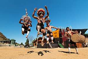 Hornbill Festival
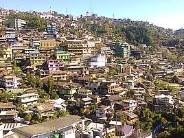 Kohima City
See also
- Tourism in North East India
References
- "Kohima City Population Census 2011 - Nagaland". 2011 Census of India. 2015.
- Dougherty 2008, p. 159.
- Ritter 2017, p. 123
- "Britain's Greatest Battles". National Army Museum. Retrieved 15 December 2015.
- "Maps, Weather, and Airports for Kohima, India". Retrieved 10 June 2015.
- "Kohima Home NIC". Retrieved 10 June 2015.
- "History". District Kohima. Retrieved 8 October 2019.
- Bert Sim, Mosstodloch, Aberdeenshire, Scotland: Pipe Major of the Gordon Highlanders at Kohima: his home is named "Kohima." -- RJWilliams, Slingerlands, NY/USA
- "Epitaph". Archived from the original on 10 May 2015. Retrieved 10 June 2015.
- "Kohima, India Köppen Climate Classification (Weatherbase)". Weatherbase. Retrieved 15 February 2019.
- "Station: Kohima Climatological Table 1961–1990" (PDF). Climatological Normals 1961–1990. India Meteorological Department. July 2010. pp. 447–448. Archived (PDF) from the original on 16 February 2020. Retrieved 16 February 2020.
- "Extremes of Temperature & Rainfall for Indian Stations (Up to 2012)" (PDF). India Meteorological Department. December 2016. p. M158. Archived from the original (PDF) on 5 February 2020. Retrieved 16 February 2020.
- "Kohima Municipal Council, Location of Kohima Municipal Council". kohimaonline.in. India Online.
- "Administration of Kohima, Kohima District Administration". kohimaonline.in. India Online.
- "Kohima CDP Revised" (PDF). Government of Nagaland. July 2006. Archived from the original (PDF) on 7 January 2012. Retrieved 11 October 2017.
- "Kohima Municipal Council". kmc.nagaland.gov.in. 31 March 2017.
- Sechü, Neidilhoutuo (26 July 2013). "Slow Train Ride to Zubza". Eastern Mirror. Archived from the original on 4 December 2014. Retrieved 23 May 2018.
- "The Sentinel". Archived from the original on 3 March 2016. Retrieved 10 June 2015.
External links
| Wikimedia Commons has media related to Kohima. |

- Official website
| States | |
|---|---|
| Cities | |
| Legislative Assemblies | |
| Protected Areas |
|
| Mountains | |
| Lakes | |
| Monasteries | |
| Others |
|