Itanagar
Itanagar (/ˌiːˈtɑːnəɡər/;![]()
Itanagar | |
|---|---|
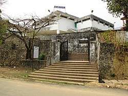 Jawaharlal Nehru Museum, Itanagar | |
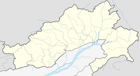 Itanagar Location of Itanagar in Arunachal Pradesh  Itanagar Itanagar (India) | |
| Coordinates: 27°06′00″N 93°37′12″E | |
| Country | |
| State | |
| District | Papum Pare |
| Government | |
| • Body | Itanagar Municipal Council |
| Elevation | 320 m (1,050 ft) |
| Population (2011) | |
| • Total | 59,490 |
| Time zone | UTC+5:30 (IST) |
| Vehicle registration | AR-01, AR-02, ARX |
| Climate | Cwa |
Geography
Itanagar is located at 27.1°N 93.62°E. It has an average elevation of 320 metres.
Climate
Itanagar features a humid subtropical climate (Köppen: Cwa), with dry, mild winters and warm, wet summers.
| Climate data for Itanagar | |||||||||||||
|---|---|---|---|---|---|---|---|---|---|---|---|---|---|
| Month | Jan | Feb | Mar | Apr | May | Jun | Jul | Aug | Sep | Oct | Nov | Dec | Year |
| Record high °C (°F) | 27.2 (81.0) |
30.0 (86.0) |
33.9 (93.0) |
33.7 (92.7) |
35.6 (96.1) |
35.8 (96.4) |
38.0 (100.4) |
36.6 (97.9) |
35.2 (95.4) |
35.6 (96.1) |
31.3 (88.3) |
28.9 (84.0) |
38.0 (100.4) |
| Average high °C (°F) | 23.4 (74.1) |
25.0 (77.0) |
27.8 (82.0) |
29.0 (84.2) |
31.0 (87.8) |
31.4 (88.5) |
31.9 (89.4) |
31.6 (88.9) |
31.5 (88.7) |
30.3 (86.5) |
28.1 (82.6) |
25.2 (77.4) |
28.8 (83.8) |
| Average low °C (°F) | 10.8 (51.4) |
11.2 (52.2) |
14.2 (57.6) |
17.8 (64.0) |
20.8 (69.4) |
22.8 (73.0) |
23.3 (73.9) |
23.6 (74.5) |
22.9 (73.2) |
20.2 (68.4) |
13.8 (56.8) |
10.7 (51.3) |
17.7 (63.9) |
| Record low °C (°F) | 6.6 (43.9) |
5.2 (41.4) |
8.8 (47.8) |
13.6 (56.5) |
18.7 (65.7) |
20.0 (68.0) |
20.5 (68.9) |
21.3 (70.3) |
17.4 (63.3) |
15.6 (60.1) |
9.8 (49.6) |
7.4 (45.3) |
5.2 (41.4) |
| Average rainfall mm (inches) | 33.7 (1.33) |
67.6 (2.66) |
106.1 (4.18) |
226.8 (8.93) |
468.7 (18.45) |
633.2 (24.93) |
577.7 (22.74) |
503.0 (19.80) |
492.3 (19.38) |
241.6 (9.51) |
19.2 (0.76) |
11.3 (0.44) |
3,381.2 (133.12) |
| Average rainy days (≥ 2.5 mm) | 2.5 | 5.3 | 6.9 | 12.2 | 14.4 | 19.7 | 20.5 | 16.4 | 16.2 | 8.5 | 1.8 | 1.0 | 125.4 |
| Average relative humidity (%) (at 17:30 IST) | 85 | 77 | 71 | 75 | 78 | 84 | 83 | 86 | 89 | 87 | 85 | 86 | 82 |
| Source: India Meteorological Department[1] | |||||||||||||
Culture
People
Itanagar is inhabited by a number of tribes viz., Nyishi, Adi, Apatani, Tagin, Galo, Nyishis are the aborigines of the city.
Places of interest

_diorama.JPG)
- Ita Fort, one of the most important historical sites in the state of Arunachal Pradesh. The name literally means "Fort of bricks"( brick being called "Ita" in the Assamese language). The Ita Fort was built as early as the 14th or the 15th century. The fort has an irregular shape, built mainly with bricks dating back to the 14th-15th Century. The total brickwork is of 16,200 cubic meter lengths which have been identified by some scholars with the Chutiya kingdom. The fort has three different entrances at three different sides, which are western, eastern, and southern sides.
- Jawaharlal Nehru Museum, Itanagar is also known for showcasing the rich tribal culture of the state.
- Gekar sinyi (Ganga Lake) is a beautiful natural lake which literally means confined lake in the Nyishi dialect. It is surrounded by a landmass of hard rock. Primeval vegetation, orchids masses on tall trees and tree ferns contribute to its popularity as a hot picnic spot and recreation hub. Boating facilities and a swimming pool are available at the site.
Demographics
As of 2011 India census,[2] Itanagar had a population of 59,490. Males constitute 53% of the population and females 47%. Itanagar has an average literacy rate of 66.95%, lower than the national average of 74.4%: male literacy is 73.69%, and female literacy is 59.57%. In Itanagar, 15% of the population is under 6 years of age.
Transportation
Air
Regular helicopter service is available from Guwahati to Naharlagun (Itanagar). Prime Minister Narendra Modi laid the foundation stone for the greenfield Itanagar Airport at Hollongi on 9 February 2019.[3]
Road
National Highway 415 connects Itanagar to Assam and the rest of the world. Regular bus and Innova services are available from Guwahati and Lokpriya Gopinath Bordoloi International Airport.
Railway
Naharlagun is the nearest railway station, which is nearly 15 km. away from the city. Taxi and bus services are easily available from the railway station to Itanagar. Donyi Polo Express can be availed which runs on all days of a week from Guwahati and Shatabdi Express is available thrice a week from Guwahati. Arunachal AC SF Express runs between Naharlagun and Anand Vihar Terminal twice a week which is the only direct train that connects Arunachal Pradesh with the Capital of Nation.[4]
Media and communications
.jpg)
Radio
- All India Radio, RadioCity Itanagar Arunachal Pradesh's first community radio and Big Fm 92.7 India's largest national radio network .
Newspapers
- The Arunachal Times
- Echo of Arunachal
- Dawnlit post
Education
- NERIST
- National Institute of Technology, Arunachal Pradesh
- Rajiv Gandhi Government polytechnic
- Rajiv Gandhi University
- Himalayan University
- Dera Natung Government college
- Don Bosco College
See also
- Tourism in North East India
References
| Wikimedia Commons has media related to Itanagar. |
- "Climate of North Eastern States" (PDF). Climatological Summaries of States Series - No. 19. India Meteorological Department. December 2013. pp. 270–274. Archived from the original (PDF) on 19 February 2020. Retrieved 8 March 2020.
- "Census of India 2011: Data from the 2011 Census, including cities, villages and towns(Provisional)". Census Commission of India. Archived from the original on 16 June 2004. Retrieved 1 November 2008.
- "PM Lays Foundation Of Airport, Inaugurates Another In Arunachal Pradesh". NDTV. 9 February 2019. Retrieved 11 February 2019.
- "Naharlagun–New Delhi AC Superfast Express", Wikipedia, 8 January 2020, retrieved 1 February 2020
External links

Places adjacent to Itanagar | |
|---|---|
| States | |
|---|---|
| Cities | |
| Legislative Assemblies | |
| Protected Areas |
|
| Mountains | |
| Lakes | |
| Monasteries | |
| Others |
|